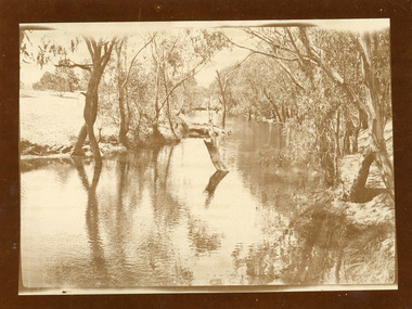
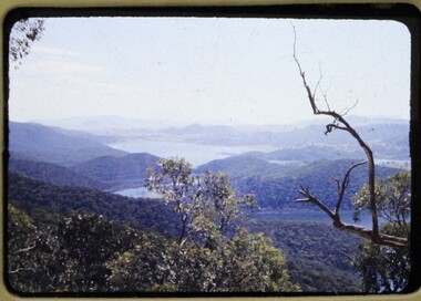
Showing 6762 items matching " rivers"
-
 Wangaratta RSL Sub Branch
Photograph, c1940
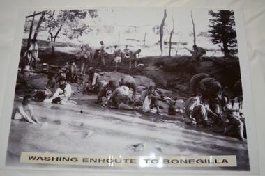
In July 1940, the 2/24th Battalion was formed in Wangaratta. On the 27th September, after weeks of hard training the Battalion marched out to Bonegilla to continue training prior to overseas deployment to the Middle East in November, 1940. This image depicts soldiers bathing and washing during the 60 mile march.The 2/24th Battalion was an infantry battalion of the Australian Army, which served during World War II .A unit of all-volunteers, it was formed in July 1940 from primarily Victorian volunteers and was known as "Wangaratta's Own" because of the time the battalion spent in the town during its formative period prior to deployment overseas. It served in North Africa in 1941–1942 as part of the 26th Brigade, which was assigned to the 7th Division, before being reassigned to the 9th Division. In early 1943, the battalion returned to Australia and later took part in campaigns against the Japanese in New Guinea in 1943–1944 and Borneo in 1945, before being disbanded in 1946. The 2/24th suffered the highest number of casualties of any 2nd AIF infantry battalion. The Unit was granted the Freedom of the City by the Rural City of Wangaratta in 1990 and one of the first, if not the first, to receive this type of honour.Reproduced black and white photograph of unknown soldiers bathing and sitting on a river bank in bush land. Washing enroute to Bonegilla2/24th battalion, wangaratta -
 Lakes Entrance Historical Society
Book, Rob Christie, Dargo Crooked River a Pictorial History 2000 edition, 1984
Short history of the Dargo Crooked River goldfield, which operated 1860 to 1900, illustrated with photographs.mines and mining -
 Lakes Entrance Historical Society
Photograph - Derrick Ruins, Rev John Flynn, 1906
This is a photograph proof on light cardBlack and white photograph of view of Deddick River north of Buchan and old Deddick ruins VictoriaDeddick Ruins P36 Johyn Flynn Postcards from Buchan -
 Lakes Entrance Historical Society
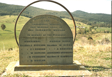
Photograph - Memorial for Pioneers of Murrindal, Roger River and Jacksons Crossing at Murrindal Victoria, Bessie Larkin, 1994 c
Colour photograph of the memorial tribute to pioneers of Murrindal Roger River and Jacksons Crossing at Murrindal Victoriahistoric site, memorials, cemeteries -
 Lakes Entrance Historical Society
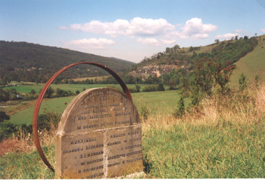
Photograph - Memorial tribute to pioneers of Murrindal, Roger River and Jacksons Crossing at Murrindal Victoria, Judy Davies, 1/03/2000 12:00:00 AM
Colour photograph of memorial tribute to pioneers of Murrindal, Roger River and Jacksons Crossing at Murrindal Victoriapioneers, mountains, settlers -
 Charlton Golden Grains Museum Inc
Photograph - Sepia Photo Avoca River 1907
Sepia Photo of the Avoca River 1907 mounted on a card backing. The photo has a black borderavoca river, charlton -
![Wal Ives & Bert [Watson] at the outlet of the Kew Main Drain](/media/collectors/550653872162f11fb04854aa/items/61593ef27608a87f688412b1/item-media/61594a5a7608a87f68848c29/item-fit-380x285.jpg) Kew Historical Society Inc
Kew Historical Society IncPhotograph - Wal Ives & Bert [Watson] at the outlet of the Kew Main Drain, c.1900
Connor's Creek is/was one of two major waterways bisecting Kew, both of which empty into the Yarra River. Connor's Creek originates near the grounds of Genazzano FCJ College, which is one of the highest points in Kew. Until the 1930s, this was an open creek until a barrel drain - the Kew Main Drain - was constructed. As the creek ran through Kew it cut across a number of roads the maintenance of which was a continuing concern for Kew Councillors. In August 1864, the Council called for tenders to erect a stone culvert and embankment over Connor's Creek, on Belford-road. This may be the embankment on which the boys are sitting.Original, small photographic positive on card of two boys, identified by the donor as 'Wal Ives and Bert' [Albert Watson] sitting on bluestone capping above an outlet of Connor's Creek. To the left of the boys is a barrel drain which at that stage was the outlet for Connor's Creek near the Yarra River. The retaining wall is constructed of brick. In ink on photo: "Wal & Bert"connors creek -- kew (vic), wal ives, albert watson, belford road, yarra river -- kew (vic.), creeks -- kew (vic.), drains -- kew (vic.) -
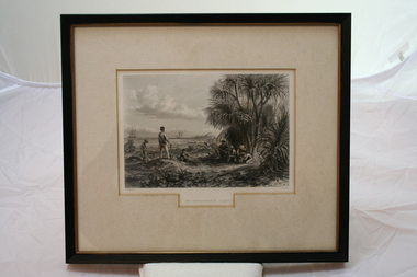 Emerald Museum & Nobelius Heritage Park
Relief prints, Thomas Baines et al, An Explorer's Camp, Circa 1875
From 'Australia' by Edwin Carton Booth. Thomas Baines joined Augustus Gregory as official artist and storekeeper, in the expedition across northern Australia between 1855-1857 sponsored by the Royal Geographical Society to evaluate the northern area of Australia for suitability as a colonial settlement. The Baines River was named after him.The item is socially and artistically significant as it is a very early image of Northern Australia.Framed black and white etching depicting a cap site located near the ocean.Artist T. Baines - J.J. Crew. From 'Australia' by Edwin Carton Booth. Thomas Baines joined Augustus Gregory as official artist and storekeeper, in the expedition across northern Australia between 1855-1857 sponsored by the Royal Geographical Society to evaluate the northern area of Australia for suitability as a colonial settlement. The Baines River was named after him.print, baines -
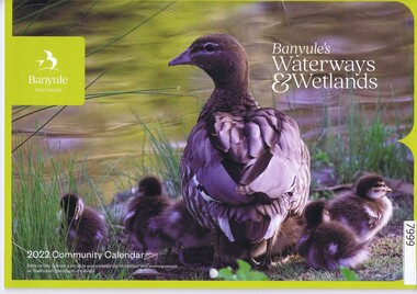 Greensborough Historical Society
Calendar, Banyule City Council, Banyule Community Calendar 2022: Banyule's Waterways & Wetlands, 2022
... rivers ...This community calendar is distributed to residents of the City of Banyule each year. Each year it focusses on an aspect of the local community. The 2022 calendar contains action photographs of local waterways and wetlands. Some council services are detailed in the back pages.The annual report is a record of the activities and services in the Banyule City Council area.30 pages. Colour illustrations. Illustrations of local waterways and wetlands. banyule city council, banyule community calendar, rivers, wetlands -
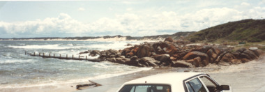 Lakes Entrance Historical Society
Photograph - Cape Conran Boat Ramp, M Fish, Cape Conran Victoria, 2000 c
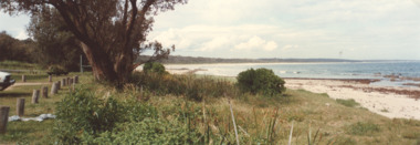
... Rivers ...Colour photograph of Cape Conran boat ramp looking west, Cape Conran Victoria.. Also a second colour photograph taken from Cape Conran boat ramp looking east waterways, boat ramp, ocean, rivers -
 Lakes Entrance Historical Society
Photograph - Car park, M Fish, Cape Conran Victoria, 2000
... Rivers ...Colour photograph of Cape Conran from car park looking eastward Cape Conran Victoria. Also a second colour photograph taken from car park at Cape Conran looking westwardwaterways, beaches, ocean, rivers -
 Orbost & District Historical Society
black and white photograph, 1920s
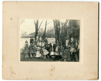
The bridge shown in the background was built in the 1920s as a road and rail bridge, and was partly washed away by flood waters in 1934. There is no known history of this item.This photograph is a contemporary record of rural life in Orbost in the early 20th century.A black / white photograph of a group of young girls dressed up and posing on the banks of a river. On the left hand side of the photograph is an older man and on the right is an older lady. In the background is a bridge - the first Snowy River bridge. The photograph is on a cream coloured buff card. orbost snowy-river -
 Flagstaff Hill Maritime Museum and Village
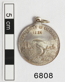
Medal - Commemorative, Centenary of Victoria, Melbourne and Portland, 1935
This commemorative medal celebrates a colonisation of two towns, now cities, in Victoria; Melbourne and Portland. The medal shows the significance placed on the colonisation of Victoria and the growth of the hundred year period. Medal, silver. with hole and ring at the top. Obverse: Sailing Ship, Coast, Boat on shore, 3 men. Reverse Colonial man on grass, river, city buildings on other river bank Medal commemorates the centenary of Victoria and Portland 1834 and Melbourne 1835. "CENTENARY OF VICTORIA 1934" & "PORTLAND 1834", "CENTENARY OF MELBOURNE 1935" & "1835" flagstaff hill, warrnambool, shipwrecked-coast, flagstaff-hill, flagstaff-hill-maritime-museum, maritime-museum, shipwreck-coast, flagstaff-hill-maritime-village, medal, centenary medal, centenary of victoria, centenary of melbourne, 1834-1934, 1835-1935, colonial, centenary of portland, colonisation of victoria -
 Bendigo Historical Society Inc.
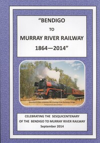
Book - BENDIGO TO MURRAY RIVER RAILWAY
Bendigo to Murray River Railway 1864 - 2014, celebrating the sesquicentenary of the Bendigo to Murray river railway September 2014. Soft cover with 198 pages with black & white and colour photos, compiled by the Historical & Genealogical Societies of Northern Victoria, edited by esma Turner.Esma Turnerbook, rural, railway, bendigo-railways-murray river railways-transport -
 Bendigo Historical Society Inc.
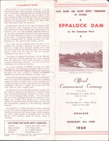
Pamphlet - Aileen and John Ellison collection: Eppalock dam
BHS CollectionState Rivers and water Supply Commission of Victoria. Eppalock Dam on the Campaspe River. Official commencement ceremony performed by the Honorable H.E. Bolte MLA Premier of Victoria and the Honorable W.J.Mibus MLA minister of water supply at Eppalock on Thursday, 9th June 1960. lake eppalock, eppalock dam -
 Lakes Entrance Historical Society
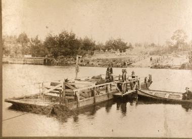
Photograph - Johnsonville Punt, Hancock, Phillip, 1920
Also black and white 10 x 15 cm copy donated by M Holding January 2012Sepia toned copy of a postcard showing the punt at the Tambo River, one man on horse, three men standing, cattle penned on punt, one man in rowing boat tied to punt. Jetty near landing on far bank of river. Johnsonville Victoria waterways, transport, animals, boating -
 Federation University Historical Collection
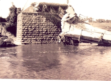
Photograph - Photographs, Richard Vincent, Washed Away Bridge at Garibaldi, c1933
Newspaper clipping documents deputations to the Minister of Public Works for grants to be made available for repairs to bridges and roads damaged by heavy flooding in 1933, in particular, the replacement of a stone and concrete bridge over the Leigh River at Garibaldi in the Buninyong Shire. The concrete slabs were still in the water in the 1960s/70s or even later. Three black and white photographs showing flood damage to the bridge over the Leigh River at Garibaldi, plus a photocopy of a newspaper clipping from The Argus December 1933 describing the extent of the flood damage. .1) shows blue stone buttress and collapsed bridge/road. .2) mirror image of above .3) unknown man waling an a girder of the Garibaldi bridge .4) photocopy of newspaper clipping about flood damage from The Argus December 1933Damage by Floods: Bridges washed away (The Argus December 1933)leigh river, garibaldi, buninyong shire, richard vincent, garibaldi bridge -
 Kew Historical Society Inc
Photograph - Yarra River, Kew, 1925
Henry Beater Christian (1886-1962) , was a descendant of one of the earliest settler families in Kew. Employed at the Kew Asylum as a 'public servant', he was a skilled amateur photographer, photographing numerous scenes in Kew and on his travels around Victoria. The majority of his photographs date from 1916 to 1929. His finest photographs are housed in two photograph albums. Digital copy of a photograph from page 3 of the 47-page photograph album containing 261 gelatinous silver images, loaned by Diane Washfold with permission given to digitise and hold a copy in our collection. The photograph is of a stretch of the Yarra River at Kew near Macauley's Boat Sheds. Of interest is the debris in the river which reminds us that the river periodically flooded, washing down trees and branches from further upriver. "Yarra Rvr / Kew / 1925"henry beater christian (1886-1962), landscape photography, kew (vic.) — yarra river, christian-washfold collection, photograph albums -
 Melbourne Legacy
Slide, Operation Firewood - Eildon Reservoir, 1960s
Colour slide of a view of Lake Eildon from Big River Road. It was during Operation Firewood. Legatees would organise collection of wood from the country and distribute it to widows in metropolitan Melbourne. Other slides show the cutting and loading of wood and delivery to widows in metropolitan Melbourne. Was with many other slides taken in the 1950s and 1960s. The slides have been photographed to make digital images and moved to archive quality sleeves. In many cases the original images were not well focussed and the digital image the best available.A record of Legacy helping widows by sourcing, supplying and delivering firewood. When open fires were the main source of heating, a load of firewood and help moving it, would have been very important to the widows.Colour slide of a view of Lake Eildon during Operation Firewood in brown Anscochrome cardboard mount.Printed on front in red ink 'Anscochrome / View from this side / Made in Australia'. Hand written on front 'Eildon Reservoir from Big River Road' in blue pen. Printed on reverse in red ink 'Processed by Verycolor photo labs. Melbourne, Victoria'.operation firewood, trees, forest -
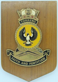 Ringwood RSL Sub-Branch
Ward Room Plaque - Torrens, C 1950
The first HMAS Torrens was a Torpedo - Boat Destroyer which served through WW1. Built at Cockatoo Dockyard in NSW she was commissioned in July 1916 and served for 10 years. In 1975 a second HMAS Torrens was in service, this time a Destroyer Escort. Ward room plaque fro the HMAS Torrens.The main symbol on the plaque is a crow confirming the ships connection to the Torrens River in South Australia. -
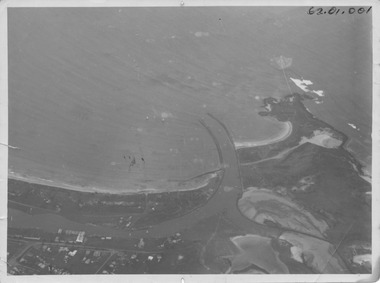 Port Fairy Historical Society Museum and Archives
Photograph, R.W.Golding, 1925
taken in 1925 by W Golding Aerial-Port Fairy Harbour 1925Black and White aerial view of Port Fairy ‘s waterways62.01.001 on front of photograph - on the back-Port Fairy Moyne River Entrance W Goldingaerial view, harbour, griffiths island, w.golding, training walls -
University of Melbourne, Burnley Campus Archives
Slide, Alan L. Mitchell
Looking across Oak Tree Lawn (showing at top of photo) towards Yarra River.alan l. mitchell, burnley gardens, oak tree lawn -
![Photograph (sub-item) - Black and White, The Wonga Park ‘swimming pool’ in the Yarra River, 1940’s – now in Jumping Creek Reserve (1985) [This may be the swimming pool in Jumping Creek Reserve or may be the swimming pool in Clifford Park in use in the 1948-9 Pan-Pacific Jamboree]](/media/collectors/5c7716e021ea6a1a60039fee/items/631b95b3d61f455ba20ef2cb/item-media/631b961fd61f455ba20ef417/item-fit-380x285.jpg) Wonga Park Community Cottage History Group
Wonga Park Community Cottage History GroupPhotograph (sub-item) - Black and White, The Wonga Park ‘swimming pool’ in the Yarra River, 1940’s – now in Jumping Creek Reserve (1985) [This may be the swimming pool in Jumping Creek Reserve or may be the swimming pool in Clifford Park in use in the 1948-9 Pan-Pacific Jamboree]
THE ROSE SERIES P. 922 SWIMMING POOL, RIVER YARRA, WONGA PARK, VIC. -
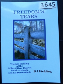 Stawell Historical Society Inc
Book, B. J. Fielding, Freedom’s Tears – Thomas Fielding - Previously Cat No 3645, 2012
Traces the life of Thomas Fielding, a farm labourer, from Sowerby in the district of Calderdale in the West Riding of Yorkshire.Light Blue card cover with colour phot of a post and rail fence.Freedom's Tears Thomas Fielding of the Gilbert River District South Australia and his Descendantsstawell -
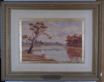 Glenelg Shire Council Cultural Collection
Painting, A.S. Murray, Scene on the River Murray, n.d
Art collection Previously located in History HouseThe painting depicts a large body of water surrounded by tree-covered riverbank. Depicted in shades of blue and grey, the water features patches of brown and blue which illustrate the reflections of riverbank trees. In the foreground to the left of the water is a large tree which extends up to cover the top left skyline of the work. Featured in the background is a dense patch of trees completed in shades of blue. To the right of the water is a dense patch of trees completed in shades of brown and black. These trees reach into a purple and blue cloud-filled sky. The work has a gilded ornate frame with cardboard and gold mount and exposed canvas.Front: A.S. Murray Plaque attached to frame: SCENE on the RIVER MURRAY Back: (no inscriptions) -
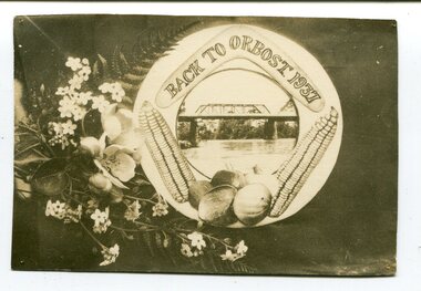 Orbost & District Historical Society
Photograph, 1937
This was a souvenir postcard made specifically for the "Back To Orbost" celebrations in 1937. The week-long celebrations were held from February 27 to March 6 in 1937 and included dances, picnics,concerts, sports, the Orbost Show and Ball. President of the organising committee was Councillor J. Perry and thesecretary was Mr M.W. Cowell.The Back To Orbost celebration in 1937 was a significant event in Orbost's history.A black / white photograph / postcard. On the left side is a collection of Australian native flowers. Net to it, inside a white circle, are two ears of corn and some pumpkins beneath a photograph of a bridge across a river (the Snowy River) with a boomerang above and "BACK TO ORBOST 1937" inside. orbost-back-to-1937 celebration postcard -
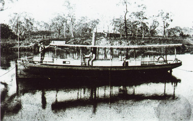 Lakes Entrance Historical Society
Photograph - SS Ariel, 1895 c
.Bairnsdale 1884 by S Erikson.Black and white photograph of SS Ariel moored in Mitchell River. Captain James Bull at wheel. Alan Anderson engineer and another man on board. High timbered bank on opposite side of river. Boat dark coloured with light coloured top. Bairnsdale Victoriaships and shipping, jetties, retail trade -
 Kew Historical Society Inc
Photograph - Victorian Canoe Club, Dight's Falls, Studley Park, 1920-30
Canoeing on the River Yarra at Melbourne was an important and widespread recreational pursuit for Melbournians, especially in the first half of the twentieth century. The Victorian Canoe Club was formed in 1912 at a meeting in Melbourne and its first committee elected in the same year. Records indicate that the Club continued into at least the 1950s .The album has historic and social significance as a record of recreational activities (as well as canoe making) in the early years of the twentieth century. It has local significance as the site of the headquarters of the Club was in Studley Park. A number of photographs in the album provide vistas of Kew on the Yarra that are otherwise unavailable.One of 24 labelled photos in part album, originating from the Victorian Canoe Club, which had its headquarters in Studley Park, Kew. The album includes a photographic record of canoe construction and also locations in Studley Park and Kew where the canoes were used. The subject of this photograph is identified as 'Dight's Falls, Studley Park'.The view shows an early trestle bridge across the Falls on which people, possibly members of the Club, are standing. The point of view would appear to be looking up river towards Fairfield."Dyghts Falls, Studley Park"victorian canoe club, river yarra, burke road -- kew (vic.), dight's falls -- fairfield (vic.), dight's falls -- kew (vic.), dight's falls -- yarra river -
 Flagstaff Hill Maritime Museum and Village
Photograph
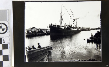
Black and White Photograph of S.S Casino arriving in port, taken 1930-1932. Decks are laden with men and women , crowd of waving people along the river bank, smoke coming from funnel. Warehouse and homes in the background. The S.S. Casino was a passenger and freight steamer built in Dundee, Scotland, in 1882 for the Newcastle and Hunter River Steam Navigation Company of N.S.W. She weighed 425 tons gross with a length of 160.4 feet, beam of 24.1 feet and depth of 10.2 feet. She had saloon accommodation for 35 people, forecabin for 25 more people, and she carried 300 tons of cargo. While on her delivery journey on May 30th 1882 the S.S. Casino called in at the Port of Warrnambool for coal ., narrowly escaping going ashore in gale force winds due to the quick action of the pilot. At that time, still at anchor, she impressed the directors of the Belfast and Koroit Steam Navigation Company so much that they bought her immediately; she was ideal for trade in along the West Coast of Victoria. (Belfast is the original name for Port Fairy, South West Victoria. The Belfast and Koroit Steam Navigation Company was first managed by Messers. Saltau and Osburne and after the passing of Mr. Osburne, by produce merchants Messers H. Sautau and Sons, whose had a hay and corn store and shipping agency was on the corner of Liebig and Koroit Streets in Warrnambool. ) The S.S. Casino became “the most famous steamer to operate in Victorian waters along the West Coast” by author Jack Loney. Captain Boyd was her first Master, followed by Captain Chapman, who stayed with her 1890 until 1924. Captain W. Robertson followed for a short term, then Captain Middleton then took command 1925 - 1932. The S.S. Casino had several mishaps during her life. One was on 3rd January 1898 when she collided with the S.S. Flinders in Apollo Bay with minor damage. Another was on 24th October 1924 when she grounded on a reef at Point Hawdon near Grey River and most of her cargo (of Christmas goods) had to be dumped into the sea. Then in February 1929 she was ‘holed’ when she struck a submerged object as she entered Lady Bay, Warrnambool. On the morning of 10th July 1932, after attempting to berth at Apollo Bay jetty in heavy seas, Captain Middleton decided to take her out into the bay and wait until the seas abated. It was not realised that the anchor used to steady her as she manoeuvred to her berth had pierced her hull. She put about and headed for the beach but sank. Captain Middleton and nine others lost their lives; nine people were rescued including the two female passengers . Captain Middleton had been in charge of the S.S. Casino for seven years. He was the first ship’s Master to lose his life through shipwreck in the West Coast trade. In the years following the turn of the century the S.S. Casino remained the only regular trader with normal passenger accommodation along the West Coast. From 1882 she had made at least 2,500 voyages on the one run. Flagstaff Hill’s collection has a photograph of a portrait of Captain Chapman, , a ship model of the S.S. Casino that shows both forms of power under which she sailed, steam and sail. The ship is painted green and flies three flags. The inscription across the case of the ship model, incorrectly dated, tells the sad story of the wreck of the ship and the loss of lives on July 10th 1932 at Apollo Bay. A print in the Collection show S.S. Casino underway in heavy sea off Point Lonsdale, another two photographs show her at the Port of Warrnambool, leaving from the Breakwater in Lady Bay and another identifies the S.S. Casino as a ship from the Belfast and Koroit Steam Navigation Company. (Belfast is the original name for the township of Port Fairy). This photograph is significant because of its association with the coastal trader S.S. Casino 1882-1932 and its significance to trade along Victoria's West Coast in the late 19th and early 20th century. The wreck of the S.S. Casino is considered an important part of Victorian and Australian cultural heritage and as such has been declared and protected as an Historic Shipwreck under State and Commonwealth Law in the Commonwealth Historic Shipwrecks Act (1976). Black and White Photograph of S.S Casino arriving in port, taken 1930-1932. Decks are laden with men and women , crowd of waving people along the river bank, smoke coming from funnel. Warehouse and homes in the background. flagstaff hill, warrnambool, shipwrecked coast, flagstaff hill maritime museum, maritime museum, shipwreck coast, flagstaff hill maritime village, great ocean road, newcastle and hunter river steam navigation company, belfast and koroit steam navigation company, h. sautau and sons, s.s. casino, west coast trader s.s. casino, victorian coastal trader, captain boyd, captain w. robertson, captain chapman, captain middleton, apollo bay shipwreck, s.s. casino at lady bay warrnambool, saltau and osburne -
 Kew Historical Society Inc
Photograph - Flooding of the Yarra Valley at Kew East, 1974
Flooding of the Yarra Valley, including that section of the Yarra bordering Kew and Kew East in the north and west of the municipality, was a regular occurrence. Extreme flood events of the Yarra River are recorded to have occurred in 1891, 1901, 1916, 1923 and 1934. The Municipality of Kew's response to these floods was to enact planning decisions restricting residential development in flood prone areas following the floods of 1916, 1921 and 1934. While floods continued after the development of the Upper Yarra Reservoir (construction 1948-57), the regularity and extent of these inundations diminished. During the nineteenth century, the land abutting the south side of the Yarra in Kew was devoted to dairy farming. In the twentieth century, before and after the construction of the Eastern Freeway, much of this low-lying area was used as golf courses and public parks.Late example of the capacity of the Yarra Valley at Kew to flood, even though drainage works and the Upper Yarra Reservoir had reduced their regularity.Original black and white print photograph of the low-lying land at East Kew under floodwater on 16 May 1974. The vantage point of the photographer is Lister Street. In the photo, the fences of the Kilby Farm can be seen. Flooding was caused by overflowing water in Glass' Creek and the River Yarra. Annotation verso: "Hay's Paddock op No.30 Lister Street / 16 May 1974 11.50am / R.L. 46.04"hays paddock, floods, yarra river, glass' creek, lister street