Showing 5706 items
matching eltham road district
-
 Eltham District Historical Society Inc
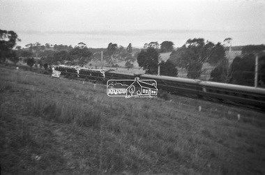
Photograph, George Burton Coop, The Royal Train enroute to Lilydale, near Croydon, 6 Mar. 1954
Believed to have been taken bewteen Croydon Railway Station and the Dorset Road bridge. Taken late afternnon by George Coop's father. There is a Landrover parked on the grass with a person standing on it - believed to be Security. George recalls originally being located closer to the fence and being ushered up the hill where it was 'safer' to stand. In 1954 at age 27, Queen Elizabeth II was the first reigning British monarch to visit Australia.. She visited Victoria between March 1-10. Where to see the Queen (1954, January 21). Fern Tree Gully and District Times (Boronia, Vic. : 1953-1954), p. 5. Retrieved October 25, 2021, from http://nla.gov.au/nla.news-article264220429 “The Lilydale Shire President, Cr. Burgi, stated that the Royal train en route for Warburton on Saturday, March 6th, would slow down at Croydon and Lilydale. There was little possibility that it would stop at either of these towns. The train would pass through Lilydale at 5.52 p.m. Council had appointed a sub-committee to arrange matters, and had allocated £400 towards expenses. It was suggested that the train slow down between the railway station and Dorset Rd. bridge at Croydon, and between the Cave Hill Quarry and railway station at Lilydale.” An album of images of the Queen's visit to Victoria is available on the PROV Flickr account at https://www.flickr.com/photos/public-record-office-victoria/7252885616Digital TIFF file Scan of Kopdak 620 black and white negative transparencygeorge coop collection, croydon, royal train -
 Eltham District Historical Society Inc
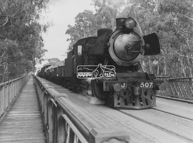
Photograph, George Coop, Steam locomotive J-507 hauling a goods train from Echuca (Vic.), Aug. 1963, Aug. 1963
Steam locomotive J-507 hauling a goods train from Echuca (Vic.) crosses the Iron Bridge over the Murray River bound for Moama (NSW), August 1963Digital TIFF file Scan of black and white print Enlargement prints on textured paper (15.5 x 20.5 cm)george coop collection, echuca, echuca-moama road rail bridge, j-507, j-class steam locomotive (vulcan foundry) -
 Eltham District Historical Society Inc
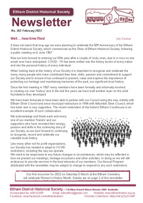
Journal - Newsletter, Newsletter, No. 262 Februray 2022, Feb 2022
Contents: • Well…..how time flies! By Jim Connor • Heritage Excursion – Eltham Cemetery – Saturday 5 March 2022, Women’s History Month • Park On Hill Crest (The Herald 5 Feb 1925) • Eltham Licensing Meeting (The Argus 17 December 1883) • That was then …. By Liz Pidgeon • Local Road and Street Names by Russell Yeoman • Eltham Races (The Argus 15 December 1855) • A 1863 halfpenny! By Calum Ryan • Frederick Edward Falkiner (1820-1881) by Peter Pidgeon • Contacts for the Eltham District Historical Society The Shire of Eltham Historical Society was formed in October 1967. The first newsletter of the Society was issued May 1978 and has been published continuously ever since on a bi-monthly basis. With the cessation of the Shire of Eltham in late 1994, the Society's name was revised to Eltham District Historical Society and this name first appeared with issue No. 103, July 1995. The collection of the Society's newsletters provides a valuable resource on the history of the Society's activities, office bearers and committee members, guest speakers and subjects of historical interest pertinent to the former Shire of Eltham and the Eltham District.A4 newsletter distributed to members (Digital and A4 photocopy)newsletter, eltham district historical society, covid-19, coronavirus pandemic -
 Eltham District Historical Society Inc
Photograph, Parsons Road Bridge over Maroondah Aqueduct near Margaret Street, Eltham, 1991
Colour photographmaroondah aqueduct, aqueduct, bridge, eltham, parsons road, margaret street -
 Eltham District Historical Society Inc
Photograph, Charles and Annie Cockcroft in front of their grocer shop and attached house, cnr of York Street and Main Road, Eltham, c.1935
Charles Cockcroft born Bundanoon, NSW, 1885, died 1966 and Annie Cockcroft (nee Green) born Lismore, NSW, 1881, died 1943. They are buried together in Eltham Cemetery. On 28 Nov 1931 C.R. Nicholls offered for auction the General Store and attached house he had built on the corner of York Street and Main Road in late 1925. The property was purchased by Charles and Annie Cockcroft from which they lived and ran their grocery business. Following the death of Annie in 1943, and prior to 1949, Charles sold the business and moved farming at Jeeralang North near Traralgon in Gippsland. References: • 1931, 1943 and 1949 Electoral Rolls (Ancestry.com) • Eltham. (1926, January 15). Advertiser (Hurstbridge, Vic. : 1922 - 1939), p. 2 (AFTERNOON). Retrieved February 23, 2022, from http://nla.gov.au/nla.news-article56659270 • Auction Sale at Eltham (1931, November 20). Advertiser (Hurstbridge, Vic. : 1922 - 1939), p. 5. Retrieved February 23, 2022, from http://nla.gov.au/nla.news-article56736611Black and white print also negative copy of print (roll of 35mm black and white negative film, 3 strips Ilford FP4)Details inscribed in blue ink on back of photoannie florence cockcroft (nee green), car, charles burgess cockroft, feed store, general store, grocer, grocers, main road, shops, vehicles, york street -
 Eltham District Historical Society Inc
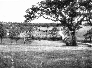
Negative - Photograph, Coghill & Haughton, On the banks of the Plenty, c.1924
Negative copy and associated print of detail from original Sales Brochure: Plenty Township Estate and Bryn Teg Hill's Estate, Coghill & Haughton, Melbourne (c.1924)Roll of 35mm Black and White negative film, 3 strips, (1 of 14 frames) Print 10 x 15 cmFilm - Agfa Ortho 25bridge, bryn teg, bryn teg hill's estate, coghill & haughton, heidelberg golf club hotel, houses, lower plenty, lower plenty bridge, lower plenty road, main road, mrs m thomas, plenty river, plenty township estate, real estate agent, sales brochure -
 Eltham District Historical Society Inc
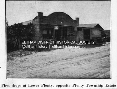
Negative - Photograph, Coghill & Haughton, First shops at Lower Plenty opposite Plenty Township Estate, c.1924
Negative copy and associated print of detail from original Sales Brochure: Plenty Township Estate and Bryn Teg Hill's Estate, Coghill & Haughton, Melbourne (c.1924)Roll of 35mm Black and White negative film, 3 strips, (1 of 14 frames) Print 10 x 15 cmFilm - Agfa Ortho 25lower plenty, bryn teg hill's estate, coghill & haughton, sales brochure, main road, plenty-township-estate, shops -
 Eltham District Historical Society Inc
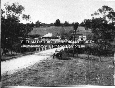
Negative - Photograph, Coghill & Haughton, Old bridge over the Plenty River near Plenty Hotel, c.1924
Negative copy and associated print of detail from original Sales Brochure: Plenty Township Estate and Bryn Teg Hill's Estate, Coghill & Haughton, Melbourne (c.1924)Roll of 35mm Black and White negative film, 3 strips, (1 of 14 frames) Print 10 x 15 cmFilm - Agfa Ortho 25bryn teg hill's estate, coghill & haughton, sales brochure, lower plenty, bridge, hotels, lower-plenty-road, plenty-hotel, plenty-river -
 Eltham District Historical Society Inc
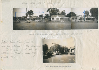
Document - Photograph, Ian McDonald (Shire of Eltham), Main Road, between Arthur Street and Dudley Street, Eltham, 1968-1970
Original document produced by Ian McDonald (Eltham Shire Council) 1970. During the period 1969-1971 photos were being collected for a proposed publication on the history of the Shire of Eltham as part of its centenary celebrations in 1971 (managed by the Shire of Eltham Historical Society and Alan Marshall). The publication was Pioneers & Painters (1971), edited by Alan Marshall. The document titled "Shows area sold to Woolworths" consisted of a panorama of three B&W photo prints creating a panorama of the frontage along Main Road (SEPP_0744) and a single B&W photo print of the Shire of Eltham offices and Hall on the corner of Arthur Street and Main Road (SEPP_0737) along with typed and hand written notes by Ian McDonald. The panorama (SEPP_0744) was captioned in typewritten text "Old Shire Office and Hall, etc - Frontage of 285 feet along Main Road" and in pencil the date "4-1-68" The single image of the shire offices (SEPP_0737) was captioned in typewritten text "Main Road and Arthur Street Corner" In addition, the following handwritten notes in pencil: " I took these photos from the new fire station - the building in the middle is the old fire station - Moved to Research for the Scouts 1970" and signed "IMcD"This photo forms part of a collection of photographs gathered by the Shire of Eltham for their centenary project book,"Pioneers and Painters: 100 years of the Shire of Eltham" by Alan Marshall (1971). The collection of over 500 images is held in partnership between Eltham District Historical Society and Yarra Plenty Regional Library (Eltham Library) and is now formally known as the 'The Shire of Eltham Pioneers Photograph Collection.' It is significant in being the first community sourced collection representing the places and people of the Shire's first one hundred years.Paper with four photos adhered in two groups with notes in typewritten text and handwritten in pencilsepp, shire of eltham pioneers photograph collection, eltham, main road, arthur street, dudley street, barber shop, cinema, commercial bank of australia, eltham fire brigade, eltham hall, eltham shire hall, eltham shire office, fire station, hardware shop, municipal offices, photographer shop, pph, produce paint and hardware centre, shire hall, shire offices, woolworths -
 Eltham District Historical Society Inc
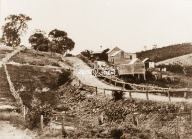
Photograph, Albert Jones, 'Golden Glen', home of photographer, Albert Jones, c.1910
The property 'Golden Glen', home of photographer, Albert Jones. At the right of the photo is an apple orchard over the other side of Watery Gully creek. The middle building in the photo is still standing, located on Wattle Glen - Kangaroo Ground Road between Pretty Hill Lane and Millers Road (Melway 271 A6) but on the opposite side of the road.Photo printalbert jones, golden glen, shops, wattle glen -
 Eltham District Historical Society Inc
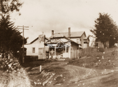
Photograph, Albert Jones, General Store, Wattle Glen, c.1910
The Wattle Glen General Store in this photo was located at the same intersection as the present Wattle Glen General Store (cnr of Reynolds Road and Kangaroo Ground Road) but on the diagonally opposite corner. [Comment from Valda via Victorian Collections June 11, 2018] "The addition to the store on the left, and the building at the back, were not part of the store/post office owned by the Keenan's. They were added by Mr and Mrs Alan (Janet) Frencham's in the ?mid-1950s."Photo printalbert jones, golden glen, shops, wattle glen -
 Eltham District Historical Society Inc
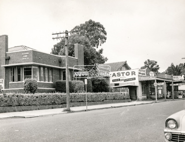
Negative - Photograph, Peter Bassett-Smith (poss), Shire of Eltham Office and Hall and adjacent shops, Main Road, Eltham, c.1961
Eltham Shire Offices 1941-1965, were located at the Corner of Arthur Street and Main Road, Eltham. The Building also incuded a community hall.Negative black and white film 120 6x6 format [Missing] One of six frames (sectioned: three continuous, two single frames and one frame missing), and Associated black and white photo printeltham, main road, arthur street, council, eltham hall, eltham shire office, shire of eltham, astor radio & tv, eltham shire council, eltham shire hall, municipal offices, shire offices, shops -
 Eltham District Historical Society Inc
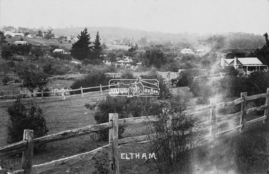
Photograph (item), J.H. Clark, View of Eltham from Main Road, c.1907
An F-class 2-4-0 steam locomotive and tender hauls a train of two open wagons, a guards van and a single Tait passenger car over the Eltham Railway Trestle Bridge, heading for Melbourne. This type of steam locomotive was replaced by the F-Class 2-4-2. The house on the right, originally known as 'Derril' was purchased in the early 1920s by Walter Ernest and Alice Miriam Gahan. On the western side of Main Road near the present-day site of Shillinglaw Cottage, they remained till about 1960 when Walter died. The house was demolished in 1968 during the widening of Main Road. In the distance beyond the trestle bridge on what would become Central Park appears to be an orchard of fruit trees. A young man with waist coat, jacket and hat stands beside an older man wearing suspenders without jacket and bare headed, sitting on the post fence. Photographer: J.H. Clark John Henry Clark was the youngest of three boys born to William Henry Clark (1823-1877) and Maria White (1843-1914). He and his brothers, William Charles Clark (1872-1945), Clement Kent Clark (1874-1912) operated a photography business (Clark Bros.) from 25 Thomas Street, Windsor near Prahran during the period c.1894 to 1914. Following death of Clement in September 1912 and their mother in 1914, the Clark Bros business appears to have dissolved, the premises demolished, and a new house was under construction in 1915. John set up business independently in 1914 operating out of 29 Moor Street, Fitzroy where he is registered in the 1914 and 1915 Electoral Rolls. By 1916 John had relocated to Eltham where he continued his practice as a photographer and took many of the early images around the district of Little Eltham. Around 1930 John changed professions and opened a small cobbler's shop in 1931 near the pond opposite Dalton Street adjacent to the Jarrold family cottage. He never married and continued his profession as a bootmaker from this little shop, maintaining a close relationship with Mrs Jarrold for the rest of their lives. His bootmaker shop remains today beside the Whitecloud cottage and is one of only three remaining shops in the area from the early 20th century. There are a couple of images of Eltham taken by Clark Bros. in the Eltham District Historical Society collection, one such example being Hunniford’s Post Office with Miss Anne Hunniford out front (EDHS_00140 - marked on the back of the print, Clark Bros., 25 Thomas St. Windsor), which would date this image between c.1894 and 1914. Other early images of Eltham taken by John Henry Clark are marked on the face “J. H. Clark Photo” and it is assumed these are dated between 1914 and 1930. It is noted that the Grant of Probate for John H Clark of Eltham South dated 5 April !957 (513/387) records his occupation as "X Photographer".derril, eltham railway trestle bridge, f-class 2-4-0 steam locomotive, gahan house, j.h. clark photo, main road, orchards, postcards, steam train, tait train, victorian railways -
 Eltham District Historical Society Inc
Photograph (item), J.H. Clark (poss), View of Eltham across Bridge Street, c.1907
The view is looking southeast from near Eltham Road (present-day Sherbourne Road) across Bolton and Bridge streets towards the village of Little Eltham running down the main road (Maria Street) . On the immediate right is Mrs Mary Jane Smart's family home located on the north side of Bridge Street at the intersection with Bolton Street, facing Bolton Street (now part of present day Brisbane Street and occupied by the Kitchen Design Centre). An original early settler's cottage, it was built by Mary Jane Smart's parents, Edwin Bailey and Jane (nee Matthews). Mary Jane Smart was born in the cottage. She married an Englishman, Alexander Wilson Smart who disappeared to Western Australia in the early 1900s in search of gold. He ultimately married again in W.A., committing bigamy and then committed murder and was hung in 1911. Visible att the top left are Watson's (two-storey) Eltham Hotel at the corner of Pitt Street and Maria Street and the Evelyn Hotel directly opposite. The photo was possibly taken by John Henry Clark of Clark Bros Photographers who operated from 25 Thompson Street, Windsor near Prahan 1894-1914.bridge street, clark bros. photo, early settlers, eltham, evelyn hotel, fountain of friendship hotel, j.h. clark photo, mary jane smart (nee bailey), smart family home, smart home, watsons hotel -
 Eltham District Historical Society Inc
Photograph, Tess Justine (Nillumbik Shire Council), Murray's Bridge over the Diamond Creek, Eltham North, 19 Feb 2022
Murray's Bridge over the Diamond Creek on the Diamond Creek Trail just prior to demolition and replacement with a new steel bridge. Heritage advice obtained by Nillumbik Shire Council, following a suggestion by the Eltham District Historical Society (EDHS), is that the original bridge appears to have been a simplified version of the Country Roads Board’s (CRB) standard timber bridge design of the early-to-mid 1920s. In c1990 Murray’s bridge was renovated with three recycled steel girders as part of a bike/pedestrian path in the reserve. During these alterations many parts of the bridge were removed, and some were replaced. Heritage advice indicates the condition of Murray’s bridge is poor. The remaining original parts are all in poor condition, with severe weathering, splitting and rot, especially to the stringers retained on the bridge. Heritage advice is that Murray’s Bridge does not have sufficient significance in the cultural history of the Nillumbik area to warrant inclusion in the Nillumbik Shire Heritage Overlay and also does not have sufficient significance as a rare survivor to warrant inclusion in the Nillumbik Shire Heritage Overlay. There are no indications in the historical record that this site was individually important to the cultural history of this area. EDHS is comfortable with the heritage advice provided to Council and has worked closely on this project with Council. EDHS has suggested some of the removed timbers be used in the vicinity of the bridge for landscaping and possibly seating, so as to retain these remnants close to the site of the original bridge, which is the last old timber bridge along the lower reaches of the Diamond Creek. Mary (Sweeney) Murray and John Wright Murray selected 80 acres, Lot C Section 16 and Lot 5 Section 17 Parish of Nillumbik, under an occupation license in 1866. John died in 1867 and freehold was granted to his son John in 1873. The farm was known as ‘Laurel Hill’. John Junior was an Eltham Shire councillor and sometime president from 1887 up until 1897. He added Lot A Section 16 to the farm in ca1888. John and his younger brother James arranged to rent/purchase Lot B Section 17, across Diamond Creek to the west, in ca1900. It appears that John and James farmed separately for a few years, with a new homestead built for James ad family on the high point of Lot B Section 17 in ca1910. John sold off Lot 5 Section 17 in 1912. When John died in 1912 James took over the land on both sides of the Diamond Creek. The old homestead on the west side of the Creek disappeared. A farm bridge over Diamond Creek from this period may have been located close to the northern boundary of the farm. John Langlands, owner of the farm known as ‘Ihurst’ on the west side of Diamond Creek to the south of the Murray’s land, died in 1907. In 1909 his land was then subdivided into 100 lots to become the ‘Glen Park Estate’. Other similar subdivisions of nineteenth century farms around Eltham in this period included the ‘Franktonia (or Beard’s) Estate’ to the northeast and ‘Bonsack’s Estate’ between Eltham and Greensborough. Soon after the opening of the railway extension line from Eltham to Hurstbridge in 1912, Glen Park and nearby residents including James Murray agitated for a railway station or siding to be located half-way between Eltham and Hurstbridge, so that the Glen Park residents who used the railway daily did not have to walk into the Eltham or Hurstbridge stations. Some believed Coleman’s Corner (opposite Edendale Farm) was an appropriate spot for the platform. James Murray was among those who thought the railway should be located on his land, closer to half-way between Eltham and Hurstbridge stations. The Railways Commissioners warned that the locals would have to fund these works themselves. The Glen Park Estate residents initially had difficulty accessing Eltham by road, with only an old low-level bridge over Diamond Creek at the south end of their estate. A new timber trestle bridge across the creek, now on Wattletree Road, was opened in 1915. Road access to the north was gained in 1927 when the new Murray’s Road, which crossed the Murray’s land, was built. Residents continued to agitate for a Glen Park station. By 1926 the Railways Commissioners’ preferred site was on the Murray’s land. They arranged an estimate of cost of a full-length platform. The estimate was too much for the locals, who in 1928 argued unsuccessfully for a shorter and hence cheaper platform. By 1929 Murray had agreed to donate the land, but the locals would still have to fund the works. Murray decided, unilaterally it would appear, to commence work on a timber trestle road bridge over Diamond Creek to link the new Murray Road to the proposed station. Late in 1929 he stopped work on the bridge, for reasons unknown, but started work again and completed the bridge in 1931. There is no further newspaper evidence of the campaign for the Glen Park station until 1939, when Murray and another local, Mr Maxwell, met the Railways Commissioner. The Glen Park locale now included 45 homes on the west side of the creek and 20 on the Eltham side. Most of the residents used the train every day. The Commissioner remained adamant that only a full-length platform could be built for safety reasons. It appears the campaign dissolved at this point. The increasing move to cars may have had an impact. There is no evidence of Murray’s bridge ever being connected to Murray’s Road, or of it having wide use for any purpose by locals. James Murray died in 1947 and the farm was taken over by his son James (Jim). Jim started to sell off parts of the farm in the 1980s, retaining a few acres around the ca1910 homestead and building a new house there. Recreation reserves were established along the creek. In ca1990 Murray’s bridge was renovated with steel girders as part of a bike/pedestrian path in the reserve. The old farmhouse was demolished in ca2014. * * * A theory posted on local community Facebook groups was that the bridge was built in the 1860s and was built to be more robust than was necessary for the movement of cows from one side of the creek to the other. It was suggested the robustness was necessary to support the weight of gold ore being transferred from a mine on Murray’s land to a railway siding near Murrays Bridge (presumably for transfer and processing at Diamond Creek). Perhaps this may have been one of the motivators for Murray, who really knows? Knowing when mining operations ceased on his land and how that fits the overall timeline would be useful but at the time the bridge was built, local gold production was minimal at best. The known facts are: • The railway line came to Eltham in 1902. • The extension of the railway from Eltham to Hurstbridge was constructed in 1912 so no railway line even existed through Murray's property until 1912 and the Victorian Railways maps at the time show no such siding on Murray’s property. • In 1923 a new company was formed in anticipation of the old Diamond Creek Gold Mine being re-opened. The mine had been previously closed and flooded. It was noted in the press at the time that the mine was within a mile of the railway. Nothing really came of this. • Construction of Murrays Bridge was commenced by James Murray in early 1929 in anticipation of a proposed flag station being nominated on his land, but work ceased shortly afterwards. The proposed flag station was commonly referred to as Glen Park as the residents of the Glen Park Estate wanted Option 1, located near them with the platform adjacent to Colemans corner. This was probably never going to fly as it was virtually in eyesight of Eltham station. Allandale Road was the third option, but the Commissioners' preferred option was No. 2 - on Murray's property. • The Railway Commissioners were not going to finance any such station and the works had to be funded by private landowners and residents, hence Murray investing in this himself. • Murray recommenced work two years later and finished his bridge in 1931 but unfortunately for him, the proposed flag station never eventuated. The bluestone siding you reference may well have been built by Murray as part of the proposed station platform. • Up until then, apart from the Main Road bridge, which was washed away in 1924, virtually all local crossings over the Diamond Creek were low lying bridges – Kaylocks Bridge at Brougham Street, Diamond Street bridge, Glen Park Road bridge. It is expected that Murray also had a low-lying bridge to connect his land either side of the creek. These were all washed away or severely damaged multiple times in the 1920s. Lessons were learnt, and Murrays Bridge appears to have been built in accordance with Country Road Board standards of the time. Flood damage was ongoing, and even more recently constructed raised bridges kept getting washed away, e.g., the new Wattle Tree Road bridge in 1958 just months after completion. Murray’s bridge was reinforced with steel some 30 years ago presumably to provide additional floodwater resistance, given the history of bridges disappearing in floodwaters. • In March 1932 it was reported in the Advertiser that there were still some prospectors operating around Eltham North who apart from further scarring the face of the earth over the previous two years had gained significant experience but little gold - hardly a driving factor for constructing a dedicated railway siding and bridge to transfer gold ore. It is far more probable that James Murray was hoping to have the railway station located on his property and invested his money by building the bridge to lead to it as well as a station platform. Had the station eventuated, it may well have driven up the value of his land for subdivision and new housing estates like the Glen Park Estate. That did not eventuate. Whilst the bridge was indeed old (90 years), the core structure being completed in 1931, it had been modified substantially from original and hence had no significant historic value – i.e., it was not a representative example of its type, construction, and age. Given that the bridge was not worthy of saving, the Eltham District Historical Society with Council’s support, and the Eltham Woodworkers group endeavoured to see what suitable sized timbers were salvageable to fabricate a commemorative seat. Unfortunately, the experts at the Woodworkers group were unable to salvage any suitable length/width timbers to fabricate the seat due to the presence of rot. Last remaining wooden trestle bridge on the Diamond Creek Trail just prior to demolition and replacementBorn digital image (27)diamond creek (creek), diamond creek trail, murrays bridge, ‘laurel hill’, john wright murray, mary (sweeney) murra, john murray jnr, james murray, john langlands, ‘ihurst’, ‘glen park estate’, beard's estate, franktonia, bonsack's estate, glen park estate, glen park railway station -
 Eltham District Historical Society Inc
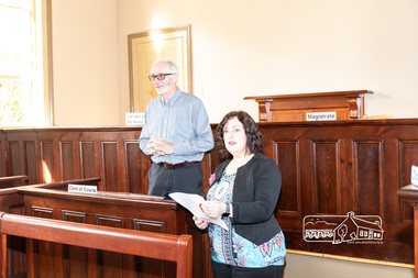
Photograph, Peter Pidgeon, Official opening of the restored Eltham Courthouse, 730 Main Road, Eltham, 23 Mar 2022
Eltham Courthouse Officially Reopened (Jim Connor, EDHS Newsletter No. 263 April 2022) In the Conservation Management Plan prepared in 2006 for the Eltham Justice Precinct there is mention that more than 350 court houses have been built by the Public Works Department since 1856, when the Department was established. It also states Eltham was in an early group of 'Victorian Free Classical' structures, featuring a projecting entry porch and gabled roof. Characteristically, this group shares a simple, rectangular shape, central placement of the court room with smaller-scale offices set back at the sides or rear of the court room, arched openings, and decorative string courses. The Statement of Significance listed in the Victorian Heritage Register states: ‘The Eltham Court House dates from the time when the town was largely self-contained. It was initiated in response to itinerant gold prospectors who turned to crime when their quest was unsuccessful. This type of localised solution is characteristic of the self reliance preserved in Eltham today. The court house is an important symbol of the spirit which makes Eltham distinctive as a community.’ It also states: ‘The Eltham Court House, built in 1860, is one of only two intact examples in the state of this simple design with projecting entry.’ So with this background it is most appropriate this valued historic building has recently been the subject of a total restoration, as detailed in previous newsletters. This was a major project undertaken by Nillumbik Shire Council. At a small function in the Eltham Courthouse, on 23rd March 2022, Nillumbik Shire Council Mayor Fran Eyre declared the fully restored building officially reopened. In doing so the Mayor spoke about the earlier law and order function of the court and the importance of this building to the Eltham community. Wingrove Ward Councillor Geoff Paine then highlighted the importance of historical societies and groups within the shire and their valued activities in recording and preserving their local history. EDHS president Jim Connor thanked everyone involved with the project and provided an overview of the history of the courthouse. Michael Ioannides, Council’s project manager, spoke about how the restoration process proceeded and those involved in undertaking the works required. Cr. Natalie Duffy, various council officers, EDHS executive committee members, as well as representatives of the head contractor Ducon Building Services and the heritage advisors, RBA architects and Conservation Consultants, were also in attendance, as was a representative of Nillumbik U3A. After the formal part there was some light hearted interpretation of how past legal proceedings may, or may not have, occurred within this courthouse, before some refreshments were shared in the former second courthouse at the rear, which is now utilised by Nillumbik U3A. This was a successful celebration of a very worthwhile project.Born digital image (38)conservation consultants, cr. geoff paine, cr. natalie duffy, ducon building services, eltham courthouse, eltham district historical society, eltham justice precinct, jim connor, mayor cr. fran eyre, michael ioannides, nillumbik shire council, nillumbik u3a, opening ceremony, rba architects, restoration project -
 Eltham District Historical Society Inc
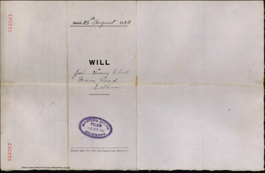
Document - Will, J.H. Clark, John Henry Clark, Main Road, Eltham, 25 Aug 1953
Last will and testament of John Henry Clark, photographer and bootmaker of Main Road, Eltham South. Appointed Executor John Francis Carrucan of Dalton Street, Eltham.bootmakers, j.h. clark photo, john francis carrucan, john henry clark, photographer, probate, prov, will -
 Eltham District Historical Society Inc
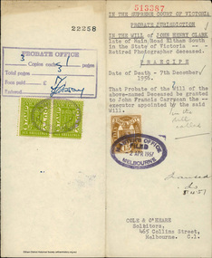
Document - Grant of Probate, Supreme Court of Victoria et al, In the Will of John Henry Clark, Main Road, Eltham South, 5 Apr 1957
Probate of the Will of John Henry Clark, photographer and bootmaker of Main Road, Eltham South granted to John Francis Carrucan of Dalton Street, Eltham, the Executor of the Will.bootmakers, j.h. clark photo, john francis carrucan, john henry clark, photographer, probate, prov, will -
 Eltham District Historical Society Inc
Document - News Clipping, Auction - Part of Eltham history
Copy of undated article headed "Auction part of Eltham history" regarding sale of property at 816 Main Road, Eltham (In March 2020 the site of Goodstart Early Learning Eltham) on the corner of John Street owned by the Burgoyne Family.1 page A4 photocopyHG Booklet 37816 main road, burgoyne, h. burgoyne, harry burgoyne, harry gilham collection, hawthorns, john james thomas neville burgoyne -
 Eltham District Historical Society Inc
Document - News Clipping, The News, Big Crowd Sees Eltham P.O. Opening, 31 Jan 1958
Copy of newspaper article: "Big crowd sees Eltham P.O.Opening "The News" dated January 31, 19581 page A4 photocopyHG Booklet 37burgoyne, eltham post office, harry gilham collection, main road, eltham -
 Eltham District Historical Society Inc
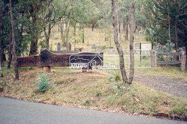
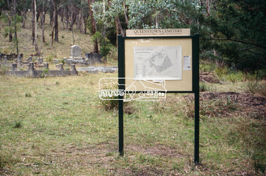
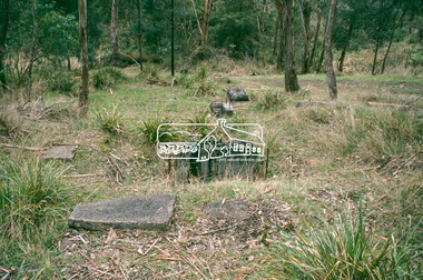
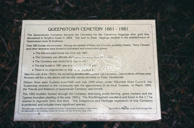
Slide - Photograph, Queenstown Cemetery, Smiths Gully Road, St Andrews, c.2004
The discovery of gold in Smyth's Creek in 1854 and subsequent gold rush to the Caledonia diggings led to the establishment of Queenstown (present day St Andrews). The first recorded burial was July 31st, 1861 and it was officially declared a Cemetery Reserve in 1866. Many graves are unmarked and unrecorded including many Chinese and other itinerant miners. The cemetery was closed for new burials in 1851. The last recorded burial was in 1981 in an existing family grave.35mm colour positive transparency Mount - white 7 dots (Technodia Italy)queenstown cemetery, smiths gully road, st andrews -
 Eltham District Historical Society Inc
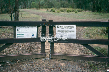
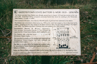
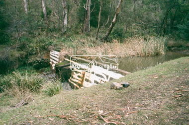
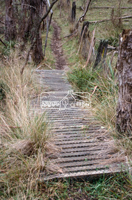
Slide - Photograph, Smiths Gully to St Andrews, Nature History Trail, c.2004
Situated opposite Queenstown Cemetery35mm colour positive transparency Mount - white 7 dots (Technodia Italy)smiths gully road, st andrews, nature history trail, smiths gully -
 Eltham District Historical Society Inc
Slide - Photograph, Smiths Gully to St Andrews, Nature History Trail, c.2004
Situated opposite Queenstown Cemetery35mm colour positive transparency Mount - white 7 dots (Technodia Italy)smiths gully road, st andrews, nature history trail, smiths gully -
 Eltham District Historical Society Inc
Slide - Photograph, Smiths Gully to St Andrews, Nature History Trail, c.2004
Situated opposite Queenstown Cemetery35mm colour positive transparency Mount - white 7 dots (Technodia Italy)smiths gully road, st andrews, nature history trail, smiths gully -
 Eltham District Historical Society Inc
Slide - Photograph, Smiths Gully to St Andrews, Nature History Trail, c.2004
Situated opposite Queenstown Cemetery35mm colour positive transparency Mount - white 7 dots (Technodia Italy)smiths gully road, st andrews, nature history trail, smiths gully -
 Eltham District Historical Society Inc
Slide - Photograph, Smiths Gully to St Andrews, Nature History Trail, c.2004
Situated opposite Queenstown Cemetery35mm colour positive transparency Mount - white 7 dots (Technodia Italy)smiths gully road, st andrews, nature history trail, smiths gully