Showing 12334 items
matching reserves
-
 Bendigo Historical Society Inc.
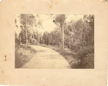
Photograph - BOTANICAL GARDENS
sepia photograph on cream board. Driveway/pathway, gravelled, eucalypt and conifer trees, uncut grass, wire fence middle distance. Pathway curving to left from front of photo. Written in blue pen on rear of photo : Botanical Gardens or early path in Fortuna. English trees planted, e.g. cypress. Holdsworth Road, adj. White Hills Cemetery Reserve. Crowned road grade. Heavy intermediate fence posts.unknownplace, land, botanical gardens, fortuna ? -
 Bendigo Historical Society Inc.
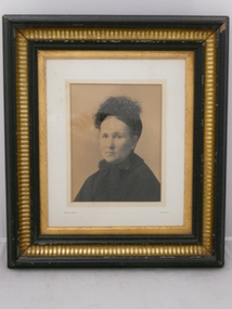
Photograph - MRS PIEPER, 1880
Black and white photo of Mrs Pieper. She is wearing a high neck dress and a small ostrich feather hair decoration. On back.. Dorothy Pieper of Piepers Hill. Atho? Pieper. Gilt frame. D1 533. Bartlett Bros. Sandhurst. From W.H.Brown. Practical Picture Frame Maker. Carver and gilder. Plush worker wtc. View street. Bendigo. Opposite Sports Ground. Upper reserve. Tram pass the door.Bartlett Bros, Sandhurstperson, individual, portrait female, pieper, pieper's hill, woman, hat -
 Bendigo Historical Society Inc.
Document - NEW CHUM & VICTORIA LINES OF REEF - NOTES ON VICTORIA HILL FOR TOURIST ATTRACTION
Handwritten notes outlining a plan for Victoria Hill, Central Nell Gwynne and New Chum Hill to be the focal position for a tourist attraction. Outlines steps to be taken to do the work and a mining museum at the Central Nell Gwynne. On the back of the page is a sketch of Victoria & New Chum Hills. On the plan is the Battery, Rae, Rae's House, Rae's Open Cut, Wittscheibe, Midway, Victoria Quartz, Lansell's 180 Shaft and the Recreation Reserve.document, gold, new chum & victoria lines of reef, new chum & victoria lines of reef, notes on victoria hill for tourist attraction, central nell gwynne, new chum hill, bendigo and district tourist development association, victoria hill, lansell's big 180, victoria quartz, rae, rae's house, rae's open cut -
 Bendigo Historical Society Inc.
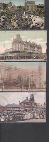
Postcard - BENDIGO POSTCARDS
Eleven postcard featuring 1907-9 views of Bendigo. 1. Returned Soldiers Monument. 2. Gold Jubilee Statue, 3. Lake & Picnic Pavilion, 4. State School Eaglehawk, 5. School of Mines 6. Entrance to Eaglehawk Gardens, 7. View Point & Fountain, 8. The Shamrock Hotel, 9. Mitchell St View, 10. Easter Fair Procession. 11. Lake Scene Upper Reserve.bendigo, parks and gardens -
 Whitehorse Historical Society Inc.
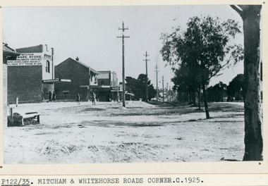
Photograph, Whitehorse Road, Mitcham, C1925
Black and white photo of Whitehorse Road, Mitcham looking west -1925. Note the Mitcham Hardware Store (Ironmongery), the Post Office and Drake & Co. Section shown is further west than actual corner. Monty Gray's ironmongery was approximately half way down the block between Mitcham Road and Station Street. Horse trough later moved to front of Reserve Hotel. Drake and Co. shown on one of their several locations.whitehorse road, mitcham, mitcham post office, drake & co, mitcham hardware store, ironmongery -
 Bendigo Military Museum
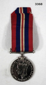
Award - MEDAL, c.1939 - 1945
Sidney Charles ROUSE enlisted in the 2nd AIF on 5.12.1942 Regt No VX119373 age 28 years. He was discharged from the Army on 24.10.1945 with the rank of WO2 in the 2nd Aust Supply Reserve Depot AASC.The War Medal 1939 - 45 with ribbon attached.On front in Latin around outside edge: GEORGIVS VII GBR:OMN:REX ET INDIAE. IMP On back: 1939 - 1945 On outer edge: VX119373 S C ROUSEmedals, military, history -
Phillip Island and District Historical Society Inc.
Newspaper clippings
Article on dangers to native animals and birds on Phillip Island due to tourism and need for greater State and Federal Government finance to protect them. Includes photographs of Ventnor Koala Reserve and debris in Penguin nest.Article on dangers to native animals and birds due to tourism on Phillip Island.local history, documents, newspapers, newspaper clipping, phillip island wildlife, black & white newspaper clipping, phillip island wildlife, tourism -
 Greensborough Historical Society
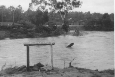
Photograph - Digital image, Plenty River in flood 1972 at Rand Street crossing (3), 1972_
Plenty River in flood Greensborough 1972. There were two major floods in Greensborough at the time, 1972 and 1974. Poulter Reserve was created after the 1972 flood and had to be re-established following the 1974 flood.Digital copy of black and white photograph.plenty river, floods -
 Eltham District Historical Society Inc
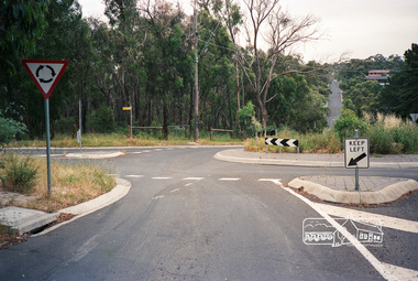
Photograph, Eucalyptus Road and Pitt Street/Nyora Road roundabout, Eltham
Looking north along Eucalyptus Road, showing roundabout at intersection of Pitt Street and Nyora Road, Eltham. Parks Victoria owns and manages the Pauline Toner Eltham Copper Butterfly Reserve on the left of the image. Colour photographeucalyptus road, pitt street, nyora road, roundabouts, eltham, pauline toner eltham copper butterfly reserve, pauline toner butterfly nature conservation reserve -
 Eltham District Historical Society Inc
Photograph, Eucalyptus Road and Pitt Street/Nyora Road roundabout, Eltham
Looking north along Eucalyptus Road, showing roundabout at intersection of Pitt Street and Nyora Road, Eltham. Parks Victoria owns and manages the Pauline Toner Eltham Copper Butterfly Reserve on the left of the image.Roll of 35mm colour negative film, 4 stripsFuji 100eltham, eucalyptus road, nyora road, pitt street, roundabouts, pauline toner eltham copper butterfly reserve, pauline toner buttefly nature conservation reserve -
 National Vietnam Veterans Museum (NVVM)
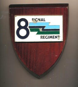
Plaque - 8 Signal Regiment plaque
8th Signals Regiment (8 Sig Regt) is an Army Reserve Signal Regiment of the Royal Australian Corps of Signals (RA Sigs) and is a direct command unit of the 2nd Division, Randwick Barracks in Sydney, NSW.Shield-shaped wooden plaque with white rectangular moulded metal attachment, bearing number 8 and a flash shape in green and blue.8 Signal Regiment8 signal regiment, plaque, signal -
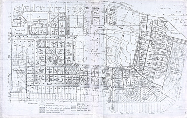 Robin Boyd Foundation
Document, Plan
Plan of Eastlakes development NSW (north of Botany) with home units, housing commission, shopping centre and public reserve between Gardeners RD, Universal Street, Grafton Street, Florence Street and Maloney Street.Photocopy, double page taped on reverse. Handwritten and typewritten. -
 Bendigo Military Museum
Headwear - HELMET, UNITED NATIONS
Helmet belonged to "Gordon Bruce Bearman". Served in the Citizen Military Forces - Nov 1965 to April 1979. Army Reserve Aug 1980 - Oct 1984. Part of this time was spent in Cyprus with United Nations Peacekeeping. Blue painted helmet with United Nations insignia on front. Initials "UN" on right hand side. Inside of helmet is brown in colour. Adjustable webbing is attached with rivets to inside to fit wearer's head. Chin strap missing.On transfer on right hand side "UN" , united nations peacekeeping, uniform, helmet, gordon bruce bearman -
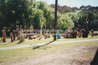 Eltham District Historical Society Inc
Photograph, Fay Bridge, Leigh Conkie's chainsaw sculptures, Main Road, Eltham, 21 October 2000
These chainsaw sculptures were created by Leigh Conkie at his home in Main Road. There were so many at times it would be a regular sight to see them sprawled across the public reserve adjacent to his home.fay bridge collection, 1305 main road, 2000-10-21, chainsaw sculpture, eltham, leigh conkie, main road -
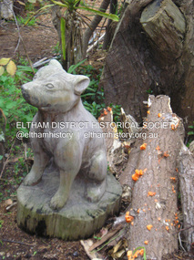 Eltham District Historical Society Inc
Photograph, Fay Bridge, Leigh Conkie's chainsaw sculptures, Main Road, Eltham, n.d
These chainsaw sculptures were created by Leigh Conkie at his home in Main Road. There were so many at times it would be a regular sight to see them sprawled across the public reserve adjacent to his home.fay bridge collection, 1305 main road, chainsaw sculpture, eltham, leigh conkie, main road -
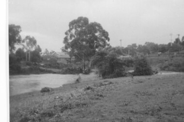 Greensborough Historical Society
Photograph - Digital Image, Plenty River in flood 1972, view at the Rand Street Crossing, 1972_
Plenty River in flood at the Rand Street Crossing. There were two major floods in Greensborough at the time, 1972 and 1974. Poulter Reserve was created after the 1972 flood and had to be re-established following the 1974 flood.Digital copy of black and white photograph.plenty river, floods -
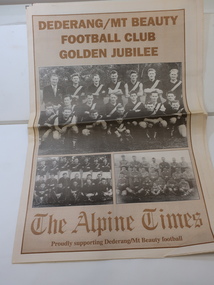 Kiewa Valley Historical Society
Newspaper Supplement - Dederang/Mt Beauty Football Club, Dederang/Mt Beauty Football Club Golden Jubilee
The Dederang/Mt Beauty Football Club held a golden anniversary reunion at the Dederang Recreation Reserve to celebrate 50 years of football and affiliation with the Tallangatta League. Celebrations also included the Bogong and Tawonga football clubs.The Alpine Times 8 page Special Feature Supplement titled the 'Dederang/Mt Beauty Football Club / Golden Jubilee Celebrations' published July 29, 1998. Includes articles and photos.dederang/mt beauty football club, kiewa valley football, bogong and tawonga football clubs, tallangatta football league -
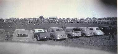 Lake Bolac & District Historical Society
black & white photograph, Football Grand Final at Lake Bolac, 1951
Football Grand Final between Willaura and Streatham teams at the original Recreation Reserve at Lake Bolac, 1951. On the hill in the centre background are the original weatherboard football clubrooms, which were later replaced by a brick building.lake bolac, football grand final, 1951, willaura, streatham -
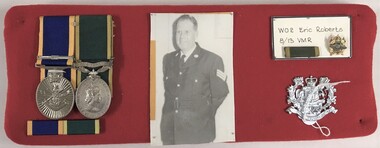 8th/13th Victorian Mounted Rifles Regimental Collection
Medal - WO2 E Roberts
Eric Roberts was an Albury resident who joined 8/13 Victorian Mounted Rifles as a trooper and rose through the ranks to Warrant Officer Class Two. He was awarded the Efficiency Medal and the Reserve Forces Medal.Fabric covered board with two medals, ribbon bar, photograph and 8/13 Victorian Mounted Rifles badge relating to Warrant Officer Class Two Eric Roberts RFM EM.em, rfm, roberts -
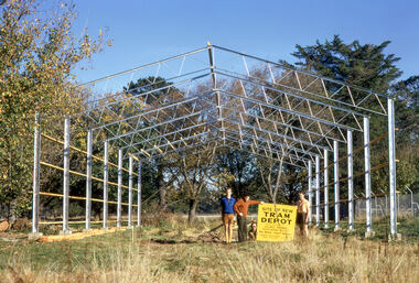 Ballarat Tramway Museum
Photograph - Digital Image - BTPS Depot under construction, Paul Nicholson, 6/5/1972
Photo taken during the work construct the Ballarat Tramway Preservation Society depot in the South Gardens Reserve on 6 May 1972. From left - Paul Nicholson, Bill Jessup, Neville Gower and John Fitzsimons.Yield information about early BTPS activities and the depot construction.Digital image of five BTPS members holding a sign about the work being undertaken.btps, btps depot, construction, ballarat, tramways, tramway museum -
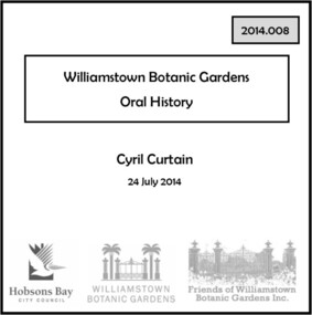 Williamstown Botanic Gardens- Hobsons Bay City Council
Oral History - Williamstown Botanic Gardens - Cyril Curtain, 24 July 2014
The interview is one of a series recorded in 2013-2014 to document memories and experiences of the Williamstown Botanic Gardens Cyril Curtain was born in Williamstown in 1928. He attended North Williamstown Primary School and Williamstown High School. Shortly after marrying he purchased a house on the Esplanade, where he still lives and in which this interview took place. Cyril’s work in conservation of the natural and built heritage is highly regarded. The recently developed Cyril Curtain Reserve in Williamstown is named in his honour. In this interview Cyril discusses the Gardens and the foreshore area including the beach and L A Parker Reserve A primary source of information on memories of the Gardens.CD and transcript of interview with Cyril Curtain and his memories of the Gardens and surrounding environs.fish pond, curator, cannons, williamstown botanic gardens, hobsons bay city council, aviary, pinetum, centennial reserve, midsummers night dream, cable tram car seats, infrared photography, , rotunda, gloucester reserve, 1934 storm, national trust, bateman house, clarke statue -
 Ringwood and District Historical Society
Photograph, Ringwood Reserve, East Corner, Looking south to the "Mail" office, mid 1960's
4 copies of same photograph with various inscriptionsTyped below one photograph, "Ringwood Reserve, 1963. Looking south Rusty Roof is "Ringwood Mail". 1966. Another has "Ringwood Oval Looking South. Rusty Roof is "Mail"Office in Adelaide St. Area No Eastland. 1965 on reverse. Another two have dates of 1962. -
 Ringwood and District Historical Society
Flyer, Subdivisional Land Auction Sale Brochure, Grand Central Estate, Ringwood, Vic. - 1925
Douglas Street shown in the estate plan did not eventuate, but was developed as a public reserve. Refer also to Reg. No. 5149 for 1924 auction sale of land also titled Grand View Estate situated further north in Ringwood.Double sided multi-folded page advertising public auction sale on Saturday, 31st October, 1925, of residential allotments highlighting local facilities, services and layout of the estate. Includes panoramic view of Ringwood and other local photographic images.Subdivision includes Great Ryrie Street, Heathmont Road, Douglas Street, Garden Street, and Bellevue Avenue. Agents - Knight & Harwood, 315 Collins Street, Melbourne, Phone 10615, 10616 Central, in conjunction with J.B. McAlpin, Opposite Railway Station, Ringwood. Phone Ringwood 7. -
 Greensborough Historical Society
Photograph - Digital image, Old orchard at Partington Flat, 1930c
Remnants of the Partington orchard at Greensborough on land that is now the Partingtons Flat reserve in Greensborough. Charles Partington and family came to Melbourne in the 1840s and moved to Greensborough where they farmed along the Plenty River. This dog belonged to Jessie Partington.Digital copy of black and white photograph.partingtons flat, partington family -
 Sunbury Family History and Heritage Society Inc.
Photograph, Sunbury News Office, c1892
The building is the first Sunbury News Office that was owned by Arthur Boardman. In 1892 he began publishing the' Sunbury News' in this printing office which was on railway reserve near the station, which today is the bus terminal at Sunbury Station. The 'Sunbury News' was distributed throughout the Shire of Bulla and surrounding areas for almost 7 decades.A faded sepia non-digital photograph backed onto fawn coloured cardboard of a shop building with five people standing outside. sunbury news, arthur boardman -
 Ringwood and District Historical Society
Photograph - (Multiple), Maroondah City Council Award to Ringwood Historical Society 26 January 2019 - Community Event of the Year - 60th Birthday Open Day, 26/1/2019
This award is in recognition for the Society's 60th Birthday Open Day ExhibitionRDHS was nominated for an award for our Ringwood and District Heritage Open Day, held on 27 October 2018. The Society was announced as the winner at the Maroondah City Council Australia Day Awards Ceremony held at Ringwood Lake Reserve on 26th January 2019. It was accepted by RDHS President Russ Haines. This catalogue item consists of 4 photographs taken on the day by Ken Briscoe. (Edited/Cropped). See Item 11000 for the actual award certificates and BookletNone -
4th/19th Prince of Wales's Light Horse Regiment Unit History Room
Slide Plate, Cinema Advertising, 1980 (estimated)
Glass Plate, 80 x 80 mm, cinema advertising. Orange background. In black borderded 40 x 25 mm rectangle - black print on yellow fill - "Join up 4/19 Prince of Wales Light Horse George Street FITZROY". Next to this message is a picture of M113A1 Armoured Personnel Carrier, under which is "Army Reserve The Ready Men" Note incorrect spelling of unit title: "Wales" instead of "Wales's"advertising, army recruiting, cinema, glass slide, advertising, army recruiting, cinema, glass slide -
 Ringwood and District Historical Society
Photographs, 1979-80 MMBW pipe line project at Hubbard Reserve, North Ringwood � Compressor unit in backyard
Part of a 43-photo record of the MMBW�s engineering feat in drilling a 12 inch pipe line up to 40 feet deep through rock hardened by volcanic action associated with geological fault that occurs along the line. The work took place from October 1979 to May 1980 on the southern boundary of Hubbard Reserve, North Ringwood. The collection was presented to the Ringwood Historical Research Group by J Clarke on 9th June 1980.E560 N23 Jan 1980 A43 Compressor unit in backyard of 39 Burlock Avenue -
 Ringwood and District Historical Society
Photographs, 1979-80 MMBW pipe line project at Hubbard Reserve, North Ringwood � Work on boring mole pit
Part of a 43-photo record of the MMBW�s engineering feat in drilling a 12 inch pipe line up to 40 feet deep through rock hardened by volcanic action associated with geological fault that occurs along the line. The work took place from October 1979 to May 1980 on the southern boundary of Hubbard Reserve, North Ringwood. The collection was presented to the Ringwood Historical Research Group by J Clarke on 9th June 1980.E560 N22Jan 1980 A43 Work on mole boring pit in 39 Burlock Avenue backyard -
 Ringwood and District Historical Society
Photographs, 1979-80 MMBW pipe line project at Hubbard Reserve, North Ringwood � Filling at 29 Burlock Avenue
Part of a 43-photo record of the MMBW�s engineering feat in drilling a 12 inch pipe line up to 40 feet deep through rock hardened by volcanic action associated with geological fault that occurs along the line. The work took place from October 1979 to May 1980 on the southern boundary of Hubbard Reserve, North Ringwood. The collection was presented to the Ringwood Historical Research Group by J Clarke on 9th June 1980.E560 N10 Dec 1979 A43 Filling at 29 Burlock Avenue