Showing 11285 items
matching tea-tree
-
 Marysville & District Historical Society
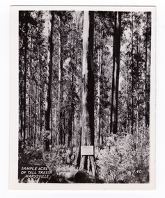
Photograph (item) - Black and white photograph, Valentine Publishing Co. Pty. Ltd, Sample Acre of Tall Trees, Marysville. V. 40, 1923-1963
An early black and white photograph of a sample acre of tall trees near Marysville in Victoria.An early black and white photograph of a sample acre of tall trees near Marysville in Victoria. After the devastating 1939 ‘Black Friday’ bushfires, Victoria’s tallest known trees were to be found in the Cumberland scenic reserve, 20 km north-east of Marysville. This stand of trees was set aside in the 1920s to preserve a ‘sample acre’ of tall trees. It originally contained 27 trees, the tallest of which was said to be 92 m, whilst the average height was 81 m. A severe wind storm in 1959 blew down 13 trees and left the ‘tall tree’ at a reduced 84 m (Munro 1992). An examination of the crown of this tree by arborist Tom Greenwood (Tom Greenwood pers. comm. 2001) suggested that it was unlikely that it ever reached the original figure of 92 m; the current height is 81.5 m, a figure used as the starting point for this search for Victoria’s tallest trees. This photograph was published by the Valentine Publishing Co. Pty. Ltd. as a souvenir of Marysville.sample acre, tall trees, marysville, victoria, cumberland valley, valentine publishing co, photograph, souvenir, 1939 bushfires, cumberland scenic reserve -
 Marysville & District Historical Society
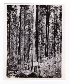
Photograph (item) - Black and white photograph, Valentine Publishing Co. Pty. Ltd, Sample Acre of Tall Trees, Marysville. V. 40, 1923-1963
An early black and white photograph of a sample acre of tall trees near Marysville in Victoria.An early black and white photograph of a sample acre of tall trees near Marysville in Victoria. After the devastating 1939 ‘Black Friday’ bushfires, Victoria’s tallest known trees were to be found in the Cumberland scenic reserve, 20 km north-east of Marysville. This stand of trees was set aside in the 1920s to preserve a ‘sample acre’ of tall trees. It originally contained 27 trees, the tallest of which was said to be 92 m, whilst the average height was 81 m. A severe wind storm in 1959 blew down 13 trees and left the ‘tall tree’ at a reduced 84 m (Munro 1992). An examination of the crown of this tree by arborist Tom Greenwood (Tom Greenwood pers. comm. 2001) suggested that it was unlikely that it ever reached the original figure of 92 m; the current height is 81.5 m, a figure used as the starting point for this search for Victoria’s tallest trees. This photograph was published by the Valentine Publishing Co. Pty. Ltd. as a souvenir of Marysville.sample acre, tall trees, marysville, victoria, cumberland valley, valentine publishing co, photograph, souvenir, 1939 bushfires, cumberland scenic reserve -
 Lakes Entrance Historical Society
Photograph - Eucalyptus Tree Mallacoota, 2005 c
Also a second colour photograph of same tree 05127.1 15 x 10 cmColour photograph of unique eucalyptus tree, eucalyptus globulus ssp pseudoglobulus eucalyptus cypella carpic. A rare localised distribution with aesthetic significance Mallacoota Victoriatrees -
 Kew Historical Society Inc
Photograph - Tree in St Anthony's Place, Kew, c.2009
St Anthony's Place in Kew was a late 20th century urban development on the site previously occupied by the early Kew mansion 'Elm Place' (later 'Madford', then 'St Anthony's Home for Babies'.) The donor of the photograph believed that the tree dated from the nineteenth century garden of 'Elm Place'.Colour photo of a tree behind a house on site of St Anthony's Home for Babies.trees -- kew (vic), st anthony's place -- kew (vic.) -
 Stawell Historical Society Inc
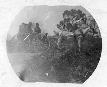
Photograph, Possibly Smith Family Photo -- on an Outing
Horse drawn hooded carriage with people in rural area, trees in the background. Possibly the Smith family from Pleasant Creek Court House. The horse and buggy both look the same as in photograph 144.Small oval photograph on white paper of a horse drawn buggy with people on board. Trees in the background and foreground.stawell transport -
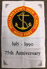 Williamstown High School
Tea towel
White linen tea towel, printed with Williamstown High School logo. This tea towel commemorates the 75th anniversary of the school.See image above.williamstown high school, 1990, tea towel -
 Stawell Historical Society Inc
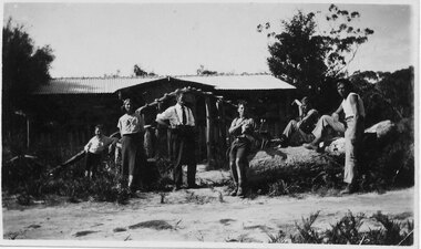
Photograph - Collection of Photos, Fisher Street: Family circa end of WW1
End of WW1 1917 -1918 - Family lived in Fisher Street. copies of 18 B/W Photos taken in yard near fence line of Path some have Peppercorn Tree. Family with pet dogs. Most men have Poppy on lapels. Geoff Bullock purchased Glass Slide Photos in garage sale in Fisher Street Stawell in early 2000'sA male standing on the grass, in front of a tree, with a wooden fence behind. -
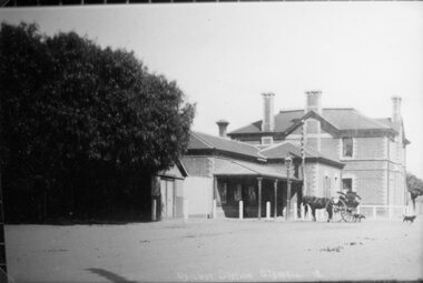 Stawell Historical Society Inc
Photograph, Railway Station Stawell
Stawell railway Station with horse and buggy in front. Large trees to left of photo. Engraved "Railway Station Stawell 12.B/W/ Photgraph of the Stawell Railway Station. form the front, A large tree to the left of the station, also a Horse and Trap, also a Gaslight.stawell railways transport, mark dadswell -
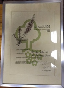 Kew Historical Society Inc
Award, State of Victoria, The Pink Heath Innovative Award: Kew Garden Club, 1979
The Pink Heath is an award by the Government of Victoria. It was awarded to Kew Garden Club in 1979 in recognition of its tree naming project.Victoria: The Garden State - The Pink Heath Innovative Award 1979. Certificate awarded to the Kew Garden Club in recognition of The Tree Naming project. Signed Rupert J. Hamerkew garden club, victoria: the garden state, pink heath award -
 Greensborough Historical Society
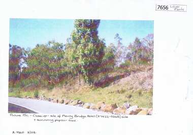
Photograph - Photograph (Copy), Anne Paul, Plenty Bridge Hotel site, 2003_03
21st century photograph of heritage site: former Plenty bridge Hotel and Tollhouse, situated on the eastern side of Old Lower Plenty Road, near the Old Lower Plenty Road Bridge on the east bank of the Plenty River. Although the Hotel burnt down, poplar trees still exist on the site.3 pages, 1 x colour photograph printed on paper, 1 x Heritage Inventory (text) and 1 historic black and white photo.On colour photograph: Close-up site of Plenty Bridge Hotel (H7922-0265) and surviving poplar tree. A. Paul 3/03plenty bridge hotel, lower plenty, plenty river -
 Halls Gap & Grampians Historical Society
Photograph - B/W, C 1930s
The people in the photo are: Mr & Mrs Gus Knight and Ray Knight (on the right). The names of the other three people are not known. The site of the house is where a later monument would stand (see inscription).Photo shows six people; three seated on a large log, two standing and one leaning on a tree stump; in front of a house."Mr & Mrs Gus Knight, Ray on right. -Where Monument will go. Ray just cut down tree - so it would not fall on house." written in biro on rear of photo. "Wannon" written in pencil on rear of photo.people, knight, buildings, tea rooms -
 Stawell Historical Society Inc
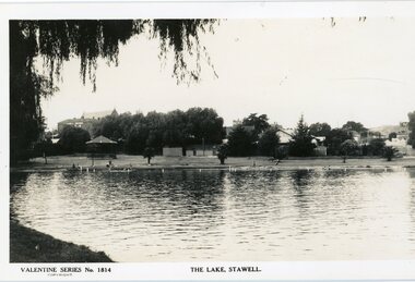
Photograph, Cato Lake looking North Pre c 1930 -- Postcard
Post Card Valentine Series pre 1930. "The Lake" Stawell. The lake has been renamed and now called Cato Lake. This view is looking north and shows distant buildings of Stawell behind a line of trees. People can be seen enjoying the lake walking and swimming with a rotunda between the trees and the lake. Valentine Series post card of The Lake, Stawell looking north pre 1930's. The back of the Coffee Palace can be seen on the left back and the roof of the Anglican church can be seen above the trees. The other side to the right are houses in Florence Street. Along the lake are people walking and enjoying the waters edge swimming. A rotunda is to the left and the post card is framed by an overhanging willow tree. Valentine Series No 1814 The Lake, Stawell. Valentine Publishing Co. Melbourne & Sydney.stawell -
 Mt Dandenong & District Historical Society Inc.
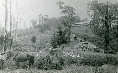
Photograph, The Busy Corner, 1907
View of Kalorama gap taken in 1907 showing Eliza Hand outside Beulah Tea Rooms, Briartys Coach, Dodd's Grocery cart and Meat Cutting cart. In foreground Fred Jeeves is standing and Theo Hand on hay. Mountjoy is in the background.This photograph has a detailed inscription on the back handwritten by John Lundy-Clarke in 1974.The Kalorama Gap in 1907. The coach road comes from right behind old stump. The shop was Hand's Beulah Tea Rooms soon to become the Mt Dandenong North Post Office. Big woman in black was Mrs Hand. wagon was Dodd's Grocery cart. "Mountjoy" on hilltop. The wagon with man was the first coach on the mount (Briartys). Small cart was Dodd's meat cutting cart. Horse at sledge was "Blossom" boy at her head was Fred Jeeves. Boy on sledge was Theo hand. Elm trees in centre of picture with Prices sign advertising shop and newsagency above them.mountjoy, beulah tea rooms, fred jeeves, theo hand, dodd's grocery cart, cart, coach, briartys -
 Marysville & District Historical Society
Photograph (item) - Black and white photograph, 10-1947
An early black and white photograph of a sample acre of tall trees near Marysville in Victoria.An early black and white photograph of a sample acre of tall trees near Marysville in Victoria. After the devastating 1939 ‘Black Friday’ bushfires, Victoria’s tallest known trees were to be found in the Cumberland scenic reserve, 20 km north-east of Marysville. This stand of trees was set aside in the 1920s to preserve a ‘sample acre’ of tall trees. It originally contained 27 trees, the tallest of which was said to be 92 m, whilst the average height was 81 m. A severe wind storm in 1959 blew down 13 trees and left the ‘tall tree’ at a reduced 84 m (Munro 1992). An examination of the crown of this tree by arborist Tom Greenwood (Tom Greenwood pers. comm. 2001) suggested that it was unlikely that it ever reached the original figure of 92 m; the current height is 81.5 m, a figure used as the starting point for this search for Victoria’s tallest trees. This postcard was published by the Valentine Publishing Co. Pty. Ltd. as a souvenir of Marysville.Tall Timber at Cumberland/ Valley. Oct. 47. 39sample acre, tall trees, marysville, victoria, cumberland valley, postcard, valentine publishing co, souvenir, 1939 bushfires, cumberland scenic reserve -
 Stawell Historical Society Inc
Photograph, Cato Lake -- with palms & trees -- Coloured
Coloured Postcard Murray Views No. 7. Cato Park Stawell Victoria. The three black and white photos are missing the larger palm tree on the right in the foreground. The view is of the lake surrounded by trees and bench seating. One colour post card Murray View No 7 Cato Park Stawell Victoria plus two similar black & white photos one smaller the other an enlargement. Also a small B&W photograph in Album 14, p28. The post card is a view of a section of the lake surrounded by willows, 2 tall pine trees and one large palm tree on the right. The lake is also surrounded by 3 concrete & wood bench seats with maybe a 4th in the distance. Murray View No 7 Cato Park Stawell Vic. On the back "Post Card Real Photograph produced in Australia by Murray View, Gympie, Q".stawell -
Hume City Civic Collection
Pamphlet, Shire of Bulla: Free Trees for Ratepayers, PlantingHints, 16th May 1992
These leaflets were distributed free of charge to residents in the former Shire of Bulla. They listed thirty-one Australian native trees that were suitable to plant in gardens in the area as well as planting hintsThe purpose of giving out free trees was to make residents aware of the importance of planting native flora in the area to encourage wild life.A four page printed leaflet containing a list of suitable trees available to ratepayers living in the former Shire of Bulla.bulla shire council, native trees, garden hints -
 The Beechworth Burke Museum
Photograph, 2000
Woolshed is a small area about five kilometres north west of Beechworth, and almost about 225km north east of Melbourne. When gold was discovered at the nearby Spring Creek in February 1852, Woolshed was one of three settlements set up to house miners and their families. At its peak in 1857, Woolshed was also populated by 29 storekeepers and 14 hotels, as well as the Woolshed State School, which stood near where this photograph was taken. The school often played host to public meetings, as well as a public dance in 1897. The school was subject to some controversy in 1874 when one parent complained about the head of the school in the local newspaper, the Owens and Murray Advertiser, and at least three letters to the editor were exchanged between the two. According to the parent, C. O'Donoghue was not providing enough amusement for the children and was disrespectful to parents and staff. When the State Governor, Sir Reginald Talbot, visited Beechworth in 1906, the school organised a celebratory welcome. The Woolshed State School was ultimately closed in 1922 as miners had exhausted the Spring Creek gold supply and were moving elsewhere. This photograph, taken in about 2000, shows the trees that grew on or near the site of the original school. The Woolshed State School Honour Roll, with a list of the men from the school who served in the First World War, also still exists. It is stored in the Beechworth RSL as of 2015.This photograph is significant for its connection to an important site in Beechworth's gold mining history. Woolshed served a significant community of miners, with a population of at least 138 according to the 1911 census, with families that needed the school site to ensure their children's education. The image is also useful for prompting discussion about how Beechworth has changed over time, with the photograph taken 78 years after the school closed down.A colour rectangular photograph printed on glossy photographic paper.Woolshed State. / School site / 2000 / - remnant trees / / cobeechworth, burke museum, school, education, trees, nature, state school, woolshed, gold mining, teachers, over time, owens and murray advertiser, public meetings, public dance, c. o'donoghue, spring creek, state governor, sir reginald talbot, miners, honour roll, world war 1 -
 Lakes Entrance Historical Society
Photograph - Esplanade Lakes Entrance Victoria 2006, Lakes Post Newspaper, 2006
west side of Myers Street from traffic island at highway intersection looking north, Queensland brush box trees in centre island Lakes Entrance Victoria 2006. The Queensland brush box trees later removed and parking bays modifiedColour photograph of west side of Myers Street from traffic island at highway intersection looking north, Queensland brush box trees in centre island Lakes Entrance Victoria 2006businesses, roads and streets -
 Marysville & District Historical Society
Photograph (item) - Black and white photograph, Unknown
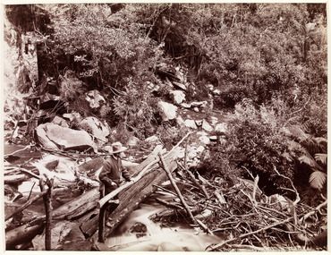
An early black and white photograph of a man attempting to repair the tree bridge which once traversed the Steavenson River at the base of Steavenson Falls.An early black and white photograph of a man attempting to repair the tree bridge which once traversed the Steavenson River at the base of Steavenson Falls. The Steavenson Falls is named after the Victorian Assistant Commissioner of Roads and Bridges, John Steavenson who arrived in Victoria in the early 1860s.steavenson falls, steavenson river, marysville, victoria, waterfalls, john steavenson -
 Bendigo Historical Society Inc.
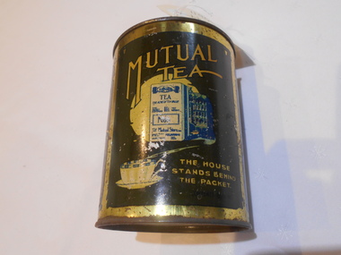
Container - MUTUAL TEA CADDY
Metal tin, dark green, gold writing. On side of tin 'Mutual Tea, the house stands behind the packet. Mutual Tea, pure economical delightful flavor' Mutual Tea was a Melbourne Company. See research tab. -
 Uniting Church Archives - Synod of Victoria
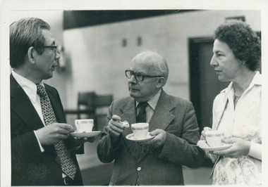
Photograph, Rev. L. Farquhar Gunn, 07/1986
Gunn was Stated Clerk of the Victorian Presbyterian Assembly until 1976. In 1986 he had been ordained 50 years. Gunn was ordained on February 12, 1936 in New Zealand. He served in three parishes before chaplaincy with the 20th Armoured Regiment in WW2. He was awarded the MBE for devotion to duty and recovering wounded soldiers across a minefield under mortar fire. He was called to St Andrew's Gardiner in 1955 and became the Stated Clerk of the Assembly in 1969, and in 1970 was also Stated Clerk of the General Assembly of Australia. He was Moderator of Victoria in 1965 and 1967. He chaired the Joint Constituional Council and the commission set up to prepare the interim constituion of the Uniting Church. He presided over the inaugural assembly of the UCA on June 22 1977 and made the declaration of inauguration.Gunn holding tea cup and talking to two people also holding tea cups, at the celebration of his 50 years of ordination.Name.gunn, l. farquhar, victorian presbyterian assembly, general assembly of australia -
Dutch Australian Heritage Centre Victoria
Set of 3 Kitchen Canisters, DRU Holland (Diepenbrock & Reigers of Ulft, Holland), 20th century
Ulft consists of three hamlets: Ulft, Oer and De Pol. Oer is the northern part of Ulft and is called Oer because of the iron in the earth, which is called IJzeroer in Dutch. The DRU, an iron foundry, was located in Ulft. DRU moved to Duiven in 1999 and may be found at the Rijksweg A12. The Ulft site is still called "De Smeltkroes", a reference to the historic foundry, but is being converted to residential accommodation on top of a shopping centrum.Such sets of 3 canisters (coffee, tea and sugar) were commonly to be found on a shelf in Dutch kitchens. 5874 (a,b,c,d,e,f) Three (3) near-identical lidded enamelled steel cylindrical canisters, green on the outside and white on the inside. The lids are of black bakelite.KOFFIE, THEE, SUIKER (coffee, tea, sugar)kitchen, coffee, tea, sugar -
 Yarrawonga and Mulwala Pioneer Museum
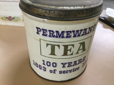
Tea Caddy
This tin was made to celebrate 100 yrs of service by the local General Store Permewans100 years celebration Round tin with lid celebrating 100 yrs of Permewans General StoreWords TEA. PERMEWANS. 100 years. service -
 Bendigo Historical Society Inc.
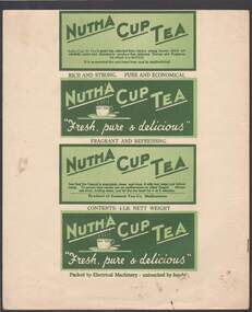
Document - CAMBRIDGE PRESS COLLECTION: LABEL - NUTHA CUP TEA
Nutha Cup Tea . Sheet with the four side labels for a packet of tea. Printed in dark green and light green on a white background. The first side has dark green printing with a dark green border and a light green background and refers to the tea. The second and fourth are the same with the colours reversed. The third is the same as the first but has Product of Eastern Tea Co., Melbourne and the weight. It also has instructions to make the cup of tea.business, printers, cambridge press, cambridge press collection, nutha cup tea, eastern tea co melbourne -
 Stawell Historical Society Inc
Photograph, Stawell Shire Hall -- Before and After trees were removed 2011 -- 3 Photos -- Coloured
Three photos showing Stawell Shire Hall after trees removed in 2011. The building is painted a brown colour and in all 3 photos the Australian flag is flying on the flag post out the front. The three photos show different views of the building. One of the photos on page 29 Album 14 shows a deciduous tree also planted on the right side of the building. Three colour photos of Stawell Shire Hall taken in 2011 showing the building without the Norfolk Island Hibiscus trees. The Shire Hall is painted a brown colour and show the brick veneer addition on the left. The three photos are in Album 14 pages 26 & 29 showing the new deciduous tree planted out the front and the brick veneer addition on the left of the Shire Hall. stawell -
 Stawell Historical Society Inc
Photograph - Collection of Photos, Fisher Street: Family circa end of WW1
End of WW1 1917 -1918 - Family lived in Fisher Street. copies of 18 B/W Photos taken in yard near fence line of Path some have Peppercorn Tree. Family with pet dogs. Most men have Poppy on lapels. Geoff Bullock purchased Glass Slide Photos in garage sale in Fisher Street Stawell in early 2000'sTwo Men Standing either side of a female, tree and fence in the background. -
University of Melbourne, Burnley Campus Archives
Newspaper - Newspaper Cutting, The Age, Behind These Hallowed Walls, 2011
Article about John Fordham's (President Friends of Burnley Gardens) involvement with the trees in the Melbourne Club garden.Article in the "Saturday Age" 12.02.2011 gardening section by Denise Gadd about John Fordham's (President Friends of Burnley Gardens) involvement with the trees in the Melbourne Club garden.the age, denise gadd, john fordham, fobg, friends of burnley gardens, melbourne club -
 Mt Dandenong & District Historical Society Inc.
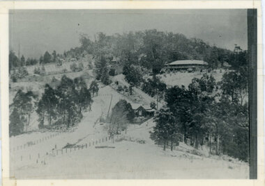
Photograph, Kalorama Gap Under Snow 1921, 1921
View of Kalorama Gap under snow taken in 1921. Mountjoy Guest House is at top right and Beulah Tea Rooms is in the centre. This photograph has a detailed inscription on the back handwritten by John Lundy-Clarke in 1974.Kalorama Gap under snow 1921 The leafless elm trees are low in the centre and the dual nature of the nearer one can be clearly seen, two small suckers of the older farther tree being twisted together in 1898 by Fred Jeeves. The older tree was planted 1880. Mrs Hands shop can be clearly seen, which was the Mount Dandenong North Post Office. The old Main Road runs up the centre of the picture and turns to the right and disappears behind “Mountjoy” the big guest house built by Paynters in 1905 and sold to Ellis Jeeves 1908, whose family ran it till 1943. At the bend of the road behind the big pine tree and the dark blackwood can be seen faintly the gable of Price’s house that contained the first shop on the mount. Above it is H Walker’s cottage on Ridge Road that still exists, his homestead is on the left of the picture on the same level. Below this house and to the left can be seen Ted Prices hay and corn store. The present estate agency lies between these two buildings, on the road which had recently been built. This can be seen winding from the lower left corner of picture to the left of the elms. The CRB had recently fenced the road and this is clearly seen as it circles behind trees in the left centre. Barber’s Road crosses CRB Road to the left of the dray under the leafless elm and the Coach Road dives down to the right just behind the pair of blackwoods to right of the elms. The picture was taken from just above the boundary of Isaac Jeeves’s selection Crown Allotment “C” (Jeeves Saddle) which stretched across the Gap to the other side of Mrs Hand’s shop, monopolising the gap from 1871 to 1879. Price’s house remains partly as the small house – “Mirra Laken”. kalorama gap, fiveways, post office, mountjoy, guest house, snow -
Tatura Irrigation & Wartime Camps Museum
Spoon - teaspoon
Issued by Department of DefenceBronze coloured metal tea spoonC of A Grosvenor plate EPNS A1department of defence, camp cutlery