Showing 112671 items
matching tracks/roads
-
 Glenelg Shire Council Cultural Collection
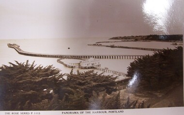
Postcard - Postcard - Panorama of Portland Harbour, n.d
Black and white photographic image of a harbour with two long piers running into it and a shorter jetty with a building on it and circular jetty protruding from it. In the foreground are trees, a dirt road to the foreground right and a railway track visible between the trees.Front: THE ROSE SERIES P. 1113/ COPYRIGHT (typed, lower left) PANORAMA OF THE HARBOUR, PORTLAND (typed, lower centre) Back: (no incriptions) -
 Ballarat Tramway Museum
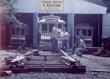
Photograph - Digital image Set of 2, Warren Doubleday, 5/01/1974 12:00:00 AM
Set of 2 digital images of: .1 - Track construction of No. 2 road at the BTPS Depot, 5-1-1974 - Gavin Young, Richard Gilbert (sitting), Geoff Cargeeg, Tony Smith and Barry McCandlish. .3 - dittotrams, tramways, btps, depot, trackwork, tram 27 -
 Ballarat Tramway Museum
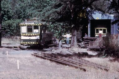
Photograph - Digital image Set of 3, Warren Doubleday, 1/01/1973 12:00:00 AM
Set of 3 digital images of: .1 - No. 27 at the end of the track so far constructed probably 1-1-1973 .2 and .3 - No. 26 and 27 out on No. 2 road, during a New Year construction push.trams, tramways, btps, depot, trackwork, tram 27 -
 Ballarat Tramway Museum
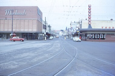
Slide - 35mm slide/s, Feb. 1963
View looking down Bridge St. from east end of Sturt St. Photographer standing before junction of tracks, looking east. No trams in photo, two or three cars on the roads. With Morseheads and Dickins stores on the corner.'Ballarat Feb. 1963, Bridge St in blue inktramways, trams, bridge st., grenville st -
 Eltham District Historical Society Inc
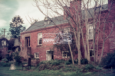
Photograph, Bismark Arms, Caledonia Street, St Andrews, c.1970, 1970c
The Bismark Arms was situated on the Heidelberg-Kinglake Road opposite the intersection of Buttermans Track. It burnt down in the late 1980s35mm colour positive transparency blue Agfacolour Service plastic mountbismark arms, buttermans track, caledonia street, heidelberg-kinglake road, st andrews -
 Eltham District Historical Society Inc
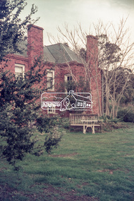
Photograph, Bismark Arms, Caledonia Street, St Andrews, c.1970, 1970c
The Bismark Arms was situated on the Heidelberg-Kinglake Road opposite the intersection of Buttermans Track. It burnt down in the late 1980s35mm colour positive transparency blue Agfacolour Service plastic mountbismark arms, buttermans track, caledonia street, heidelberg-kinglake road, st andrews -
 Greensborough Historical Society
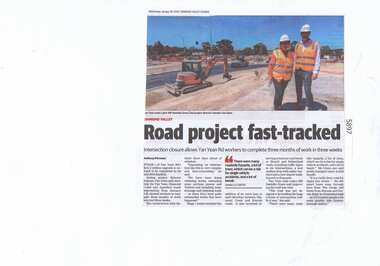
Newspaper Clipping, Diamond Valley Leader, Road project fast-tracked, 30/01/2019
Stage 1 of Yan Yean Road's $131.2 million upgrade is on track to be completed by its mid 2019 deadline.News article 1 page, black text.yan yean road, yan yean, traffic, roadworks -
 Eltham District Historical Society Inc
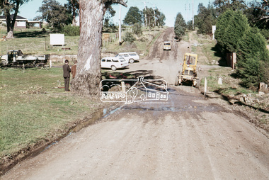
Slide, Looking south along Bonds Road towards intersection of Montpelier Drive, Lower Plenty, 18 July 1972, 1972
Water drainage work undertaken by Eltham Shire Council in Bonds Road, Lower Plenty outside the Martin property opposite Montpelier Drive, July 1972 Note blocked table drains.35 mm colour positive transparency Mount - Agfacolor Service (Blue)Bonds Road (Martin property) 12.10 pm 18.7.72bonds road, drainage works, eltham shire council, infrastructure, lower plenty, martin property, montpelier drive -
 Melbourne Tram Museum
Photograph - W2 495 at Burwood terminus Toorak Road, Doug Colquhoun, 18-3-1959
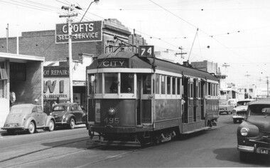
Photo shows W2 495 (Route 74, City) arriving at the Burwood terminus in Toorak Road, just before Warragul Road. The tram line was extended to Burwood East in July 1978. In the background is a Crofts Self Service store. Photo by Doug Colquhoun, 18.3.59Yield information about the Burwood tram terminus in 1959.Black and white photograph of W2 495 at Burwood terminus Toorak RoadHas details and dates on rear in ink.trams, tramways, w2 class, toorak road, tram 495, burwood, route 74 -
 Melbourne Tram Museum
Photograph - Trackwork High St St Kilda, Keith Kings, 17-3-1974
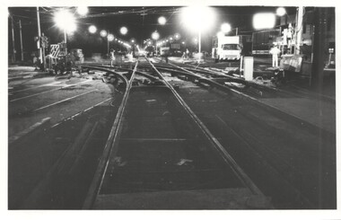
Photo shows the installation of new special work or junction at High St and Brighton Road at Carlisle St St Kilda 17/3/1974. The work was part of the major road widening project of High Street between St Kilda Junction and Carlisle St with the trams relocated into their own reservation. The track was raised 18 inches or about 450mm above the previous road level. The track was brought into use on Monday 18/3/1974.Yields information about the installation of a new junction in 1974 and the methods used.Photograph - Trackwork High St St KildaDetailed description on rear. K S Kings stamp and photo number 130-20. tramways, high st, carlisle st, trackwork, brighton road, junctions -
 Melbourne Tram Museum
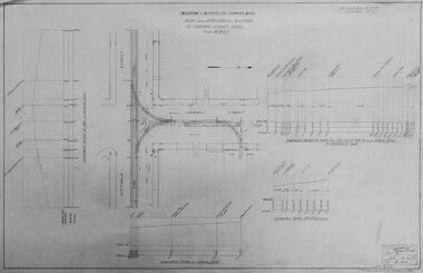
Drawing - Digtial image, Melbourne & Metropolitan Tramways Board (MMTB), "Plan and Longitudinal sections of Howard Street Siding", 2/1925
Digital image of a drawing for the access tracks to the Howard St car house or cable tram depot from Victoria St. Shows the plan and longitudinal sections. Prepared 23/2/1925 and signed by Mr Strickland Chief Engineer on 25/2/1925. This depot was made necessary by the construction of electric tram tracks in Flemington Road in 1925 which resulted in the closure of the Flemington Road car house near Racecourse Road North Melbourne.Yields information about the access track from Victoria St to the Howard St car house. Digital image of drawing P1613, "Plan and Longitudinal sections of Howard Street Siding".m&mtb, drawings, howard st, cable trams, car houses, depots -
 Geelong Cycling Club
Trophy
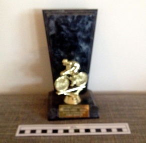
The summer aggregate road races have been conducted from the 1930s at the Geelong Cycling Club. The award is made up from points accumulated for road races during the summer season.This award provides an incentive for cyclists to perform at their best on club race days. It is interesting to note that over time awards have changed with the fashion of the time. Cycling trophies have ranged from badges in the early 1900s, to sashes in the mid 1900s, then to shields and to individual trophies.Trophy with a square base and rectangular background in grey coloured imitation marble. A figure of a cyclist in gold colour is placed on the base and there is a plaque at the front of the base."Geelong Cycling Club/Summer Series - 2007-08/Road Aggregate/John Burtt"geelong cycling club; summer series - 2007/08; road aggregate; john burtt; -
 Glen Eira Historical Society
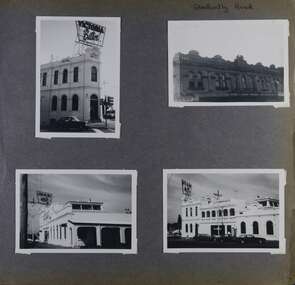
Album - Album page, Glen Huntly Road, Circa 1972
This photograph is part of the Caulfield Historical Album 1972. This album was created in approximately 1972 as part of a project by the Caulfield Historical Society to assist in identifying buildings worthy of preservation. The album is related to a Survey the Caulfield Historical Society developed in collaboration with the National Trust of Australia (Victoria) and Caulfield City Council to identify historic buildings within the City of Caulfield that warranted the protection of a National Trust Classification. Principal photographer thought to be Trevor Hart, member of Caulfield Historical Society. Most photographs were taken between 1966-1972 with a small number of photographs being older and from unknown sources. All photographs are black and white except where stated, with 386 photographs over 198 pages.Page 62 of Photograph Album with three photographs (one landscape and two portrait) of the Elsternwick Hotel exterior (front, rear and side); plus one of the first floor exteriors for 5 adjacent shops on Glen Huntly Road.Hand written: Glen Huntly Road [top right] / 62 [bottom right] trevor hart, caulfield north, glen huntly road, elsternwick, hotels, elsternwick hotel, shops, glenhuntly road -
 Ballarat Tramway Museum
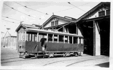
Photograph - Black & White Photograph/s, Keith Kings, 7/03/1954 12:00:00 AM
Black and White photograph contained with Reg. Item 1902 - Photo Album from Keith Kings to Les Denmead 1970. Photograph of SEC Bendigo - 2nd track cleaning tramcar (ex 17) at the depot, Easter Monday 7/3/1954. Photographed outside the depot.. Keith Kings No. I(y)(5) Scanning: i - image file, p - presentation file, b - back of photograph.Stamp in top left hand corner and handwritten number with "K.S. Kings No. I(y)(5) Copyright reserved". In blue ink "Bendigo / The second track cleaning car / Depot / Easter Monday 7/3/54".trams, tramways, bendigo, sprinkler tram, track cleaner, scrubber tram, depot, tram scrubber -
 Bendigo Military Museum
Weapon - BREN GUN CARRIER, C.1939 - 45
This item is on display in the gardens of the Bendigo District RSL Sub Branch Havilah Road. Refer photo .1) for details re manufacture, history and use..1) Plaque metal black on a stand with white text re details of the item. .2) Bren Gun Carrier or Carrier Universal Model MG No 2A, in camouflage colours, tracked vehicle.“3” - “3820”brsl, smirsl, bdrslinc, carrier, bren gun -
 Marysville & District Historical Society
Photograph (Item) - Colour photograph, Unknown
A colour photograph taken looking across Pack Road in Marysville in Victoria.A colour photograph taken looking across Pack Road in Marysville in Victoria.pack road, marysville, victoria, photograph -
 Marysville & District Historical Society
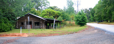
Photograph (Item) - Colour photograph, Travel Victoria, Unknown
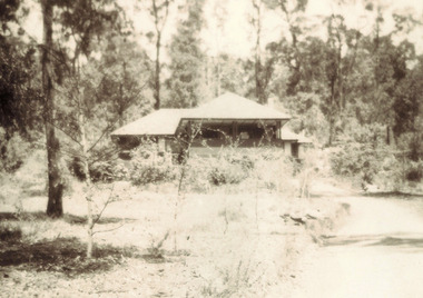
A colour photograph of the Log Cabin that was situated on Pack Road in Marysville in Victoria.A colour photograph of the Log Cabin that was situated on Pack Road in Marysville in Victoria. This was a well known business in Marysville that sold tourist related items until it was destroyed in the 2009 Black Saturday bushfires.log cabin, marysville, pack road, victoria, 2009 black saturday bushfires, photograph -
 Marysville & District Historical Society
Photograph (Item) - Colour photograph, Unknown
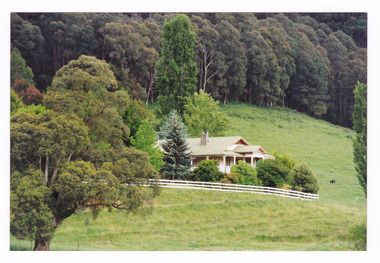
A colour photograph of a house on the Marysville-Buxton Road near Marysville in Victoria.A colour photograph of a house on the Marysville-Buxton Road near Marysville in Victoria.marysville-buxton road, marysville, buxton, victoria, photograph -
 Marysville & District Historical Society
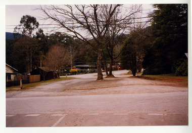
Photograph (Item) - Colour photograph, Unknown
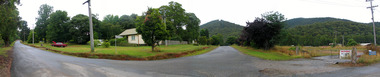
A digital copy of a colour photograph taken in Racecourse Road in Marysville in Victoria.A digital copy of a colour photograph taken in Racecourse Road in Marysville in Victoria.racecourse road, marysville, victoria, photograph -
 Whitehorse Historical Society Inc.
Article, Crash Capital of Australia, 2017
Springvale Road is the nation's worst for insurance claims for the fifth year in a row.Springvale Road is the nation's worst for insurance claims for the fifth year in a row.Springvale Road is the nation's worst for insurance claims for the fifth year in a row.whitehorse road, traffic, accidents, maroondah highway -
 Marysville & District Historical Society
Photograph (item) - Black and white photograph, 1957
A black and white photograph of Somerled Road House in Marysville that was taken in 1957.A black and white photograph of Somerled Road House in Marysville that was taken in 1957.marysville, victoria, australia, somerled holiday home, j.c. greatorex, r. greatorex, mrs d. ivey, photograph -
 City of Kingston
Photograph - Black and white, c. 1950
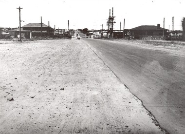
This image shows a sealed road running along South Road, although with a wide gravel shoulder. The railway crossing gates were hand operated. This image is one of many in the collections that focuses on the railway. The development of the railway was crucial to the ongoing development of the area. Community life often sprang up along and beside the railway.Black and white photograph of the railway crossing at South Road, Moorabbin, viewed from Nepean Highway. Handwritten in blue ink on reverse: 217 Handwritten in red ink on reverse: 80%moorabbin, railway, railway crossing -
 Whitehorse Historical Society Inc.
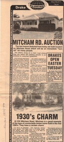
Newspaper, Mitcham Road auction, 01/04/1984,Nunawading
Advertisement for the sale of two homesAdvertisement for the sale of two homes, 265 Mitcham Road, Mitcham and 534 Mitcham road, Mitcham a 1930s timber home. Agent, drakes real estate. Photographs. Cutting from Nunawading Gazette, 18th April, 1984.Advertisement for the sale of two homesmitcham road, mitcham, no. 534, mitcham road, mitcham, no. 265, houses, drake & co. -
 Whitehorse Historical Society Inc.
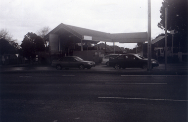
Photograph, The Railway Crossing from Corner of Springvale Road & Station, 1/06/2009
One of a collection of photographs taken of the Nunawading Railway Station prior to the lowering of the railway line and building of the new railway station on the western side of Springvale Road so that the Springvale Road Rail Crossing can be eliminated.Black & white photograph of he precinct surrounding the Nunawading Station and the Springvale Road Railway crossing. This photograph is of the Railway Crossing from corner of Springvale Road & Station. See NP 3545 to NP3567for the complete set of photographsnunawading railway station, springvale road, nunawading, redevelopment of railway line/springvale road., station street nunawading -
 Whitehorse Historical Society Inc.
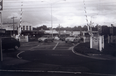
Photograph, Railway Crossing from the north, 1/06/2009
One of a collection of photographs taken of the Nunawading Railway Station prior to the lowering of the railway line and building of the new railway station on the western side of Springvale Road so that the Springvale Road Rail Crossing can be eliminated.Black & white photograph of the precinct surrounding the Nunawading Station and the Springvale Road Railway crossing. This photograph is of the railway crossing of Springvale Road, Nunawading, looking to the south of the shops. See NP 3545 to NP3567 for the complete set of photographsnunawading railway station, springvale road nunawading, redevelopment of railway line/springvale road. -
 Eltham District Historical Society Inc
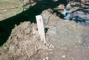
Slide, Pit on east side of Bonds Road, Lower Plenty, 18 July 1972, 1972
Water drainage work undertaken by Eltham Shire Council in Bonds Road, Lower Plenty outside the Martin property opposite Montpelier Drive, July 1972 Note rubbish excavated from pit.35 mm colour positive transparency Mount - Agfacolor Service (Blue)Bonds Road (Martin property) 12.10 pm 18.7.72bonds road, drainage works, eltham shire council, infrastructure, lower plenty, martin property, montpelier drive -
 Melton City Libraries
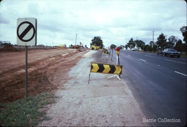
Photograph, Western Highway, 1983
Construction of service road in front of the former Ann Dowling (Miers) 1866 Crown Grant, Title dated October 1870. She married Henri Miers in 1867.Their house was located on the site near the Myers Gully part of Ryans Creek. Built in 1867 and later named “Burnbank” by Martha Myers after the Street in Ballarat were she lived before arriving in Melton in 1907. She married Frederick Myers in 1908. He died in 1963, and Martha moved to a new home at 5 McKenzie Street Melton in 1968. Attempts made by the family to retain the historic cottage were unsuccessful. A demolition order imposed by the Housing Commission and it was pulled down by the family. It was the home of the family and stood for over 100 years.East of Reserve Road towards Ferris Roadlandscapes of significance, misc. -
 Running Rabbits Military Museum operated by the Upwey Belgrave RSL Sub Branch
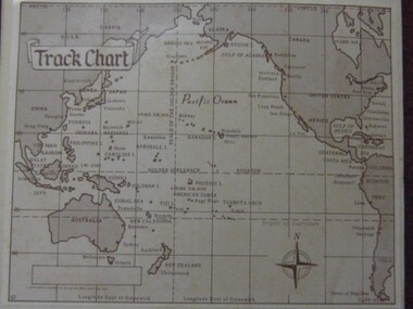
Photo
Track Chart, Pacific Ops. Areaphoto, ww2, ran -
 Running Rabbits Military Museum operated by the Upwey Belgrave RSL Sub Branch
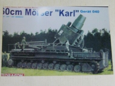
Photo
Large mobile Artillery Piece on tracksphoto, ww2, army -
Bialik College
Mixed media - Music cds for teaching and events at Bialik College
Cds created for events, as soundtrack or backing, as well as music lessons at Bialik College Please contact [email protected] to request access to this record. Multiple cds for teaching and events tracking2000s, bialik college, lessons