Showing 123777 items matching "main-road"
-
 Whitehorse Historical Society Inc.
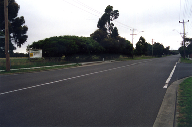
Photograph, Narmara Primary School, 13/01/1994 12:00:00 AM
Coloured photo of Narmara Primary School, looking West along Highbury Road. School on North side of Highbury Road between Middleborough and Blackburn Roads. Since demolished and site developed for housing.narmara primary school, warner, philip -
 Whitehorse Historical Society Inc.
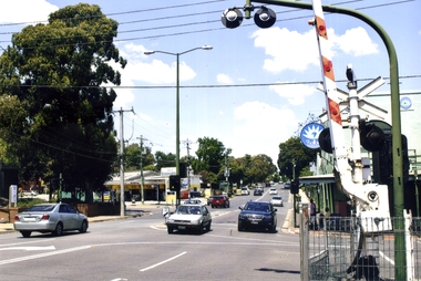
Photograph - Coloured Photograph, Blackburn Railway Crossing, 2012
See NP3400Coloured photograph of Blackburn Railway crossing on Blackburn Road. South Parade is to the right and Central Road to the left, Blackburn Library is also on the left. The photograph is looking south towards Canterbury Road - 2012blackburn railway crossing, blackburn road -
 Whitehorse Historical Society Inc.
Article, East Burwood Tram Line, 27/05/1992 12:00:00 AM
The $6.5 million stage 1 extension to East Burwood tramline will start next month.The $6.5 million stage 1 extension to East Burwood tramline will start next month. The extension will be from Middleborough to Blackburn Road and the track construction will begin February 1993. The initial plan is to extend right to Knox City. Construction will be by a combination of VicRoads, MET and private contractors.The $6.5 million stage 1 extension to East Burwood tramline will start next month. tram services, victoria. ministry of transport, vicroads, met, burwood east -
 Eltham District Historical Society Inc
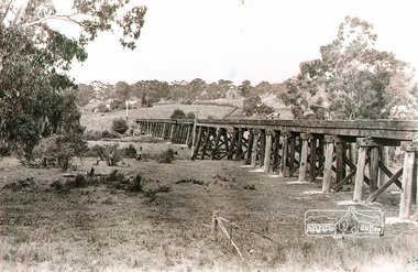
Photograph, Rural view of trestle Bridge, Eltham, c.1912
The railway was commenced in 1900 and passed through the middle of the Shillinglaw farm. The line to Eltham opened in 1902. This view shows the the new Catholic Church, St Mary's in Henry Street (near Main Road, then Maria Street) and Shillinglaw Cottage visible in background past where Eltham Town Park and later the Eltham library (1994) was built. The church site had been relocated from further south along Main Road (near Wingrove Cottage) in order to be more central to the congregation following the shifting of the township away from Little Eltham and closer to the railway station. It was subsequently destroyed by fire in 1961.Black and white photographeltham, trestle bridge, bridges, catholic church, henry street, bridge, shillinglaw cottage, shillinglaw trees, shillinglaw farm -
 Eltham District Historical Society Inc
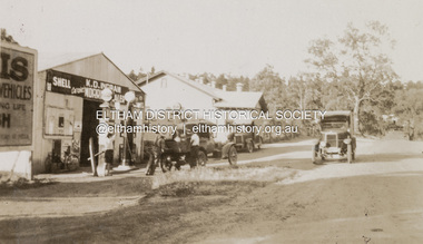
Photograph, K.D. Ingram's Shell Garage, Research, Vic, c.1930
The inscription on the back of the photo incorrectly states the garage is at Anglesea. It is in fact at Research, Victoria. Kenneth Douglas Ingram moved from Research to his holiday home at 9 Minifie Avenue, Anglesea between 1943-1949. He established a new garage at Anglesea which was a concrete block design building, not a tin shed as this at Research. This garage was located between the family home and the public hall at Research on the original line of Main Road. The public hall site is now the site of the Eltham Little Theatre. The family home, a red brick building still stands today (2023) at 1591 Main Road, ResearchOn reverse "Garage, Anglesea"k.d. ingram shell garage, kenneth douglas ingram, main road, pam thoonen (nee ingram) collection, research (vic.), research garage -
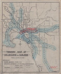 Melbourne Tram Museum
Drawing, H. S McComb, "Tramway Map of Melbourne & Suburbs", mid 1930's
Set of 19 drawings showing the development of the Melbourne tramway system between 1885 and 1921. Based on MMTB drawing "Tramway Map of Melbourne & Suburbs" P4609, 18 sheets showing year by year development of the cable and electric tram system, printed on off white paper. Mr. McComb had intended it would appear to do further work - with some 20 sheets printed on brown card paper but not used (.19 - same drawing) Each sheet has the year in red at the bottom right hand corner of the sheet. .1 - 1885 - with the Richmond line and main rail lines coloured in showing a catchment area. .2 - 1886 - shows the new cable line in Collins St and has a note that no suburban line constructed in 1886 .3 - 1887 - Bourke and northern lines and Brighton Beach to Sandringham and Hawthorn to Kew .4 - 1888 - Swanston St, Domain Road, Chapel and inner circle and towards Hurstbridge.\ .5 - 1889 - Rathdown St and Toorak Road .6 - 1890 - South and Port Melbourne, North Melbourne and Northcote. Rail lines - Ashburton and parts of the outer circle to Oakleigh. .7 - 1891 - St Kilda Esplanade and northern section of the outer circle. .8 - 1906 - NMETL .9 - 1910 - PMTT - High St and Wattletree Road .10 - 1911 - PMTT Dandenong Road .11 - 1913 - Glenferrie Road, Cotham Road, Balaclava and Glenhuntly Road .12 - 1914 - small extension in High St .13 - 1915 - Malvern Road and High St Kew .14 - 1916 - HTT and MBCTT lines and Whitehorse Road .15 - 1917 - Burke Road .16 - 1918 - Burke Road north of Camberwell station .17 - 1920 - FNPTT - St Georges Road and Plenty Road .18 - 1921 - Footscray lines .19 - base drawing only. Does not show the VR tramlines. See Reg Item 2154 for associated notes.See individual sheets.trams, tramways, times, cable trams, railways, tramways, melbourne, maps -
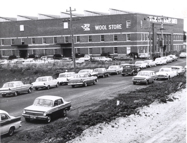 Glenelg Shire Council Cultural Collection
Photograph, Portland Wool Brokers Limited, Wool Store, n.d
Port of Portland AuthorityFront: (no inscriptions) Back: 177 (top right, pencil) -
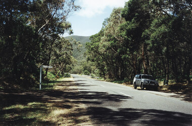 Halls Gap & Grampians Historical Society
Photograph - Coloured, 1998
Photo shows car parked at side of the road at Wannon Campground, looking north on the Halls Gap - Dunkeld Road.access routes, chalets -
Port Melbourne Historical & Preservation Society
Plan - Proposed tramway for Williamstown Road, Port Melbourne, 5 May 1887
Detailed drawings of improved steel tramway broad plate system for ordinary road, proposed for Williamstown Road 1887local government - borough of port melbourne, engineering department - borough of port melbourne -
Tatura Irrigation & Wartime Camps Museum
Photograph, 1989
Camp 1 was occupied by German and Italian internees. Coloured photograph of the entrance to Camp 1. View of camp road with a low stone wall between road and trees.camp 1, tatura victoria, german inernees, italian internees -
Whitehorse Historical Society Inc.
Article, Mirama Court, 1958
A description of the building of 'Mirama Court' on the east corner of Whitehorse Road And Mitcham Road in 1958. also a history of this site.A description of the building of 'Mirama Court' on the east corner of Whitehorse Road And Mitcham Road in 1958. also a history of this site.A description of the building of 'Mirama Court' on the east corner of Whitehorse Road And Mitcham Road in 1958. also a history of this site.shops, mirama court mitcham, mitcham shopping centre, nicholson's milk bar, mirama court fruit palace, blackburn dry cleaning service, margo rae -
Whitehorse Historical Society Inc.
Document, The Milk Bar Report
School assignment on the history of a milk bar on the corner of Beddoe Road and Centre Road, Vermont written by Douglas Nash.School assignment on the history of a milk bar on the corner of Beddoe Road and Centre Road, Vermont written by Douglas Nash.School assignment on the history of a milk bar on the corner of Beddoe Road and Centre Road, Vermont written by Douglas Nash.milk bars, beddoe road, vermont, centre road -
Whitehorse Historical Society Inc.
Article, The Drill to protect valley, 2005
First of four road-headers started drilling at Mitcham Road end of Mullum Mullum Valley tunnel, with photo.First of four road-headers started drilling at Mitcham Road end of Mullum Mullum Valley tunnel, with photo.First of four road-headers started drilling at Mitcham Road end of Mullum Mullum Valley tunnel, with photo.mitcham road, mitcham, eastlink, mullum mullum valley, aubrey, chris, batchelor, peter -
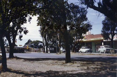 Whitehorse Historical Society Inc.
Photograph, Vermont Shops C.1967, C.1967
Part of Tim Shambrook's Collection for 'This is Vermont'. Not used.Coloured photo of Vermont Shops on corner of Canterbury and Boronia Roads, Vermont, in 1967. Looking south to Boronia Road.canterbury road, vermont, boronia road, shambrook, tim -
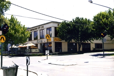 Whitehorse Historical Society Inc.
Photograph, Enrik's Restaurant, Blackburn, 2012
Coloured photograph of Enrik's Restaurant, corner of Surrey Road and Railway road, Blackburn. 3 Umbrellas in front - 2012enrik's restaurant, blackburn, restaurants, station street, railway road -
Canterbury History Group
Photograph - Street view of the Canterbury Post Office, Stuart Warmington, 1995
Coloured photograph of street view of the Canterbury Post Office on the corner of maling and Canterbury Roads at 206 Canterbury Roadcanterbury, maling road, shops, edwardian architectural design -
Canterbury History Group
Photograph - Street view from Maling Road of the Canterbury Post Office at No. 206 Canterbury Road, Canterbury, Stuart Warmington, 1995
Coloured photograph of street view from Maling Road of the Canterbury Post Office at No. 206 Canterbury Road, Canterburycanterbury, maling road, shops, edwardian architectural design -
Canterbury History Group
Photograph - Street view from Canterbury Road of the Canterbury Post Office at No. 206 Canterbury Road, Canterbury, Stuart Warmington, 1995
Coloured photograph of street view from Canterbury Road of the Canterbury Post Office at No. 206 Canterbury Road, Canterburycanterbury, maling road, shops, edwardian architectural design -
Canterbury History Group
Photograph - Street view from Maling Road of the Canterbury Post Office at No. 206 Canterbury Road, Canterbury, Stuart Warmington, 1995
Coloured photograph of street view from Maling Road of the Canterbury Post Office at No. 206 Canterbury Road, Canterburycanterbury, maling road, shops, edwar, edwardian architectural design -
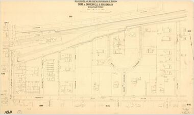 Camberwell Historical Society
Map (Item) - MMBW map, Melbourne and Metropolitan Board of Works, Melbourne and Metropolitan Board of Works - Shire of Boroondara and Camberwell - Detail Plan no. 1860, August 1904
Lithographer E.H.H., Exd J.W.D, June 1904, No. 70. 40P.15W.melbourne and metropolitan board of works, map, camberwell, cartography -
Canterbury History Group
Photograph - Streetscape along Maling road outside No. 88 Maling Road, Jan Pigot, 27/03/1993 12:00:00 AM
Coloured photograph of the streetscape outside No.88 Maling Road showing people sitting outside the Maling Road Patisserie.canterbury, maling road, shops, streetscapes, wunderlite ceilings -
Canterbury History Group
Photograph - Street view of the position of the bronze footpath plaque at the Canterbury Road and Maling Road junction, Jan Pigot, 2004
Coloured photograph of thes treet view of the position of the bronze footpath plaque at the Canterbury Road and Maling Road junction.canterbury, maling road, shops, signs, plaques -
Canterbury History Group
Photograph - Group of Maling Road traders posing for a photograph in period costume in Maling Road with the photogrpaher in view, Jan Pigot, 27/03/1993 12:00:00 AM
Coloured photograph of a group of Maling Road traders posing for a photograph in period costume in Maling Road with the photogrpaher in viewcanterbury, maling road, shops, fashion -
Canterbury History Group
Photograph - Group of Maling Road traders posing for a photograph in period costume with the photographer in view in Maling Road, Jan Pigot, 27/03/1993 12:00:00 AM
Coloured photograph of a group of Maling Road traders posing for a photograph in period costume with the photographer in view in Maling Roadcanterbury, maling road, shops, fashion -
Canterbury History Group
Photograph - Photograph of the enamel picture plaque for Maling Road in the 1920s, Jan Pigot, 2004
Coloured photograph of the enamel picture plaque for Maling Road in the 1920s on the brick wall of 80 Maling Road, Canterburycanterbury, maling road, shops, signs, plaques -
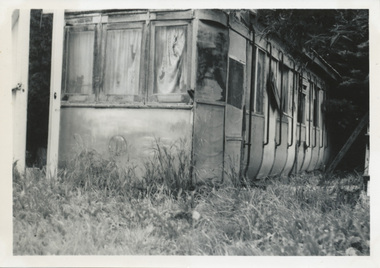 Ballarat Tramway Museum
Photograph - Digital image, Wal Jack, 23/11/1963 12:00:00 AM
Yields information how the body of a former tram was sold and use by the purchaser. Tram body later recovered by the BTM.Digital image from the Wal Jack Ballarat Album of the body after sale of ESCo 22, Sebastopol type car on a farm in Ross Creek Road, photograph on 23/11/1963. Wal Jack Photo. See image i2 for rear of photograph. See image i3 for hi res scan of print. See image i4 for hi res scan of negativeOn rear of photograph in ink "SEC Ballarat / Old No. 22 Sebastopol body in Ross Creek Road, half mile beyond Sebastopol 23/11/63" and W. Jack stamp with number "T1277"trams, tramways, sebastopol type, esco, disposal, sale of trams, tram 22 -
Whitehorse Historical Society Inc.
Article, People before profit - land sale opponent, 1992
A community group has criticised Nunawading Council's move to rezone and sell the Vermont South site it uses.A community group has criticised Nunawading Council's move to rezone and sell the Vermont South site it uses. The land is on the corner of Burwood Highway and Livingstone Road which is zoned D 'Public Open Space'. Council has deferred the decision to rezone until after a public meeting.A community group has criticised Nunawading Council's move to rezone and sell the Vermont South site it uses.town planning, city of nunawading, burwood highway, vermont south, livingstone road, vermont south, vermont south -
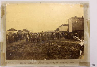 Flagstaff Hill Maritime Museum and Village
Photograph - Military group, Warrnambool First Volunteer Corps 1860, Taken May 24th, 1860, presented to Mayor in 1887
This Photograph is one of a number of photographs of the Warrnambool Militia. The photograph entitled "Warrnambool First Volunteer Corps" is dated 24th May 1860. (The First Volunteer Corps began in 1855.) It was presented by James Astley Bromfield (former Mayor of Warrnambool) to Major Walter Helpmann, head of Warrnambool’s 1st Volunteer Corps in 1887. The photograph shows the Corps lined up for inspection in Timor Street, Warrnambool. The location is outside what is now the Archie Graham Centre and the camera is looking west towards Liebig Street. The town band is in the right rear corner and spectators surround the Corps. The names listed on the back of the photograph are "1. R.Bushe (Captain in command), 2. Basil Spence, 3. Thomas Mickle, 4. Alfred Davies (Sergeant), 5. Cawthray, 6. Andrew Kerr, 7. Charles Scoborio, 8. Lacy, 9. James Hider, 10. D. O’Mullane, 11. William Norman, 12. Crouthers (or Cowthers ?), 13. Francis Breckon, 14. Russ, 15. Benjamin Wycherley, 16. C. A. Cramer (Sergeant), 17. James Coulstock, 18. Robert Newton (Sergeant), 19. J.A. Bromfield, 20. Singleton (supernumery), 21. Mostyn (Drill Instructor)," On the left of the picture is Billy Adams, Barnes (road contractor) and James Mason (Bootmaker). On the right of the picture is The Band. This is one of a collection of photographs showing the development of the Warrnambool Militia from its inception as the First Volunteer Corps in 1855. The collection is of local significance as it parallels the development of the town and includes images of significant local people. A number of Warrnambool streets are named after members of the Militia. It is also historically significant because of its connection to the unrest that was taking place in Europe at this time. Photograph of Warrnambool First Volunteer Corps 1860, sepia coloured, mounted on cream card. The photograph shows the Corps lined up for inspection in Timor Street Warrnambool. The location is outside what is now the Archie Graham Centre and the camera is looking west towards Liebig Street. The town band is in the right rear corner and spectators surround the Corps. Photograph taken 24th May 1860. Has names listed on reverse side. The protograph was presented to Mayor Helpman, by Bromfield, May 1887. Title printed below base of photo on the mounting board "May. 24. WARRNAMBOOL First VOLUNTEER CORPS. 1860" On the back of the photograph is a numbered list of names, handwritten in ink. Also on the back are presentation details "Presented to Mayor Helpman, by Bromfield, May 1887". warrnambool, wolunteer corps, militia, helpmann, bromfield, flagstaff hill, shipwrecked coast, flagstaff hill maritime museum, maritime museum, shipwreck coast, flagstaff hill maritime village, great ocean road -
Glen Eira Historical Society
Document - CAULFIELD RSL
This file contains two items pertaining to the property housing the Caulfield RSL: 1/A photocopy (2 pages) of an assessment of the property, dated 01/1997, by Andrew Ward, for purposes of ascertaining its historical significance. The assessment describes the architectural features of the property, offers a brief history of it, specifies why it should be considered significant, and recommends that it be added to the National Estate Register. Included is a black-and-white photograph of the exterior of the building. 2/An assessment (17 long pages plus appendix) of the car parking issues procured as a result of the decision to refurbish the Caulfield RSL. Prepared by Grogan Richards Pty Ltd, dated 13/11/2002, reviewed by Joanna Gauetty, and authorised by Rody Jude. Included is a description of the Club’s location and surrounding motorways as they existed at the time, a description of the Club itself (eg its opening hours and rate of patronage as per each opening hour), occupancy surveys, descriptions of other recent car parking construction within the same area, a description of the extensions the RSL is aiming to construct, and descriptions of the considerations any new construction must take into account. Included is a black-and-white map of Caulfield noting the RSL’s location, and two black-and-white photographs showing the view to the north and south of St. George’s Road, respectively.caulfield, caulfield returned servicemen league (rsl), exservice organisations, clubs and associations, ward andrew, glen eira heritage management plan, historic buildings, architectural, styles, national trust company, st. leonard’s, elsternwick club, grogan richards pty ltd, returned servicepeople, armed forces, soldiers, aged people, senior citizens centres, st. george’s road, elsternwick, english domestic revival style, moderne style, brick houses, bay windows, architectural features, prendergast ellen mrs., ford grylis, dl design group, gauetty joanna, jude rody, parking, glen eira planning scheme -
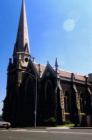 St Kilda Historical Society
Photograph, St Kilda Presbyterian Church exterior - images collection, c 1970s
The St Kilda Presbyterian Church is now part of the St Kilda & Balaclava Presbyterian Church. Its first service was inaugurated by the Free Church Synod of Victoria in May 1855, in a building at the corner of High Street and Alma Road. In October 1855 the congregation moved to a wooden building in Inkerman Street, purchased from the Independent (Congregational) Church. The present church site was purchased and the first church opened in 1860. The foundation stone for the present church building, the second to be built on the site, was laid by the Governor of Victoria, Sir Henry Brougham Loch, on 27 January 1885. The building was opened on 30 May 1886. Wilson and Beswicke were the architects. Ralph Wilson designed the Methodist church on the corner of Princes and Fitzroy Streets and lived diagonally opposite the Presbyterian church. Charles Beswicke had toured Britain and the Continent in 1886 armed with a camera and returned to Australia with photographs of what he considered the greatest examples of architecture. He was responsible for the town halls in Brighton, Malvern, Hawthorn and Essendon and Wesleyan churches in Camberwell and Dandenong. Thomas Corley was the builder. The lofty spire was ‘a landmark to the mariner’ used by sea captains sailing up Port Phillip Bay. On a prominent position, the highest point in St Kilda, the church attracted wealthy people with legal, merchant and pastoral backgrounds.colour photographst kilda, churches, presbyterian church, balaclava