Showing 7305 items
matching d
-
 Moorabbin Air Museum
Book - History notes, descriptions and photos of such vessels, grouped in sections per nations, BEFORE THE AIRCRAFT CARRIER The Development of Aviation Vessels 1849-1922, R D LAYMAN, BEFORE THE AIRCRAFT CARRIER The Development of Aviation Vessels 1849-1922, 1989
History notes, descriptions and photos of such vessels, grouped in sections per nations, BEFORE THE AIRCRAFT CARRIER The Development of Aviation Vessels 1849-1922Cover jacket showing colour painting of in flight bi-plane/seaplane with warships in backgroundnon-fictionHistory notes, descriptions and photos of such vessels, grouped in sections per nations, BEFORE THE AIRCRAFT CARRIER The Development of Aviation Vessels 1849-1922 -
Lakes Entrance Regional Historical Society (operating as Lakes Entrance History Centre & Museum)
Postcard, H D Bulmer, 1/01/1939 12:00:00 AM
Black and white postcard of Bulmers shop taken during the Black Friday bushfires showing businesses almost hidden in dense smoke from nearby fires Esplanade Lakes Entrance Victoriabusinesses, township, bushfires -
 Melbourne Tram Museum
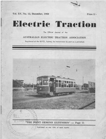
Magazine, D. R. Keenan - Managing Editor, "Electric Traction", Dec 1960 and Jan 1961
Two issues of "Electric Traction", published by the Australian Electric Traction Association, both 16 pages printed on off white paper, centre stapled. Gives details of the AETA on the rear cover. Inside the covers is a sheet of paper indicating a distribution list within the MMTB. Vol XV, No. 12 - December 1960 with a photo of 218 at Point Ormond on the front cover. Has an article by Keith Kings, Jack Stranger, Wal Jack and Ken McCarthy on Cable Tramways in Australia (continued from a previous issue), closure of Hobart, Point Ormond and general news on Melbourne and Sydney electric railways. Vol XVI, No. 1 - January 1961. Concluding article on Cable Tramways in Australia, news from Brisbane, Melbourne, Hobart, Sydney and letters to editor, book reviews.trams, tramways, electric traction, aeta, melbourne, point ormond, cable trams, hobart, sydney -
 Melbourne Tram Museum
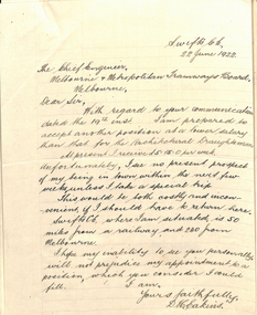
Document - Memorandum, D. H. Eakins, David Eakins appointment, Jun. 1922
Memorandum consisting of 11 quarto type and handwritten sheet or letters, appointing David Eakins as a assistant to Mr Lormer for the preparation of the General Scheme. Includes references, letter of application, and other reference material supplied by Mr. Eakins and signed by the Chief Engineer Mr Strickland. Memo to the Chairman dated 26/6/1922. Mr Eakins was to become the Chief Engineer in the 1950's. Includes a reference from Mr. Maurice Kernot chief Engineer for Railway Construction.trams, tramways, chief engineer, personnel, staff, engineers, general scheme -
Lakes Entrance Regional Historical Society (operating as Lakes Entrance History Centre & Museum)
Book, Morrissey D W and Morrissey E W, Lakes Entrance a Short History and Tourist Guide
A short history of lakes Entrance from early settlement, including references to forest survey, land sales, shipping, fishing industry and development of the town and tourist industry A short history of lakes Entrance from early settlement, including references to forest survey, land sales, shipping, fishing industry and development of the town and tourist industrysettlers, land settlement -
 Glenelg Shire Council Cultural Collection
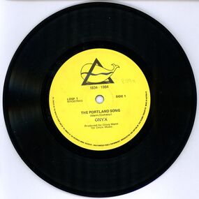
Functional object - Record - The Portland Song / Irish Melody, n.d
45rpm record. Side 1 - 'The Portland Song' and side 2 - 'Irish Medley' Record, 45 rpm, black vinyl, yellow label, Portland's 150th logo on label. Produced for Portland's 150th anniversary. Record is in a white paper sleeve.Back: a. 17.5 diameter b. 18.3 x 18.3portland 150th anniversary, record, 45rpm, music -
 Glenelg Shire Council Cultural Collection
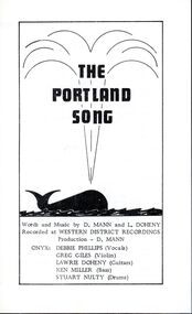
Pamphlet - Pamphlet - 'The Portland Song', c. 1984
White single fold leaflet, containing the words to 'The Portland Song'. Black print, illustration of whale on front. -
Linton Mechanics Institute and Free Library Collection
Book - Short stories, Johnson, Dorothy M, The hanging tree, 1959
American frontier stories.267 p. : plain brown cover, title and author's name in gold on spine.fictionAmerican frontier stories.fiction, historical fiction, dorothy m. johnson -
 Darebin Art Collection
Artwork, other, D Harding, white collared, 2017
queensland -
 Lakes Entrance Regional Historical Society (operating as Lakes Entrance History Centre & Museum)
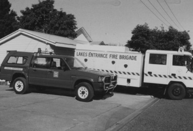
Photograph, D Mathey, 1994
Sepia toned photograph of Mobile Equipment Van purchased by Fire Brigade from Grants and Charities Fundraising, with 4WD Dual Cab utility. Lakes Entrance Victoriafire brigade, volunteering, vehicles -
 National Vietnam Veterans Museum (NVVM)
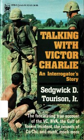
Book, Sedgwick, D.,Torison, Jr, Talking with Victor Charlie: an Interrogator's Story, 1991
The fascinating true accoint of the VC, NVA, the Golf of Tonkin Incident, the tunnels of Cu Chi, and much, much more.The fascinating true accoint of the VC, NVA, the Golf of Tonkin Incident, the tunnels of Cu Chi, and much, much more. 1961-1975 - military intelligence, vietnam war, 1961-1975 - personal narratives, american, vc, nva, golf of tonkin, cu chi, tunnels of cu chi -
 National Vietnam Veterans Museum (NVVM)
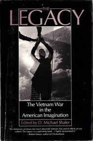
Book, Shafer, D. Michael ed, The Legacy: The Vietnam War in the American imagination
No American can know too much about the Vietnam War and its effects on our culture.No American can know too much about the Vietnam War and its effects on our culture.vietnamese conflict, 1961-1975 - united states -
 Lakes Entrance Regional Historical Society (operating as Lakes Entrance History Centre & Museum)
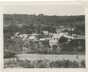
Postcard, H D Bulmer, 1945c
Lakes Entrance Oil Shaft complex which was in production c 1943 to 1952 situated in low terrain north of the town between Myers Street and Palmers Road Lakes Entrance VictoriaBlack and white postcard of Lakes Entrance Oil Shaft complex Lakes Entrance Victoriaoil, exploration -
 Lakes Entrance Regional Historical Society (operating as Lakes Entrance History Centre & Museum)
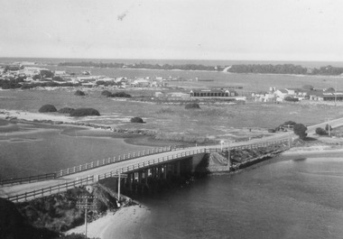
Postcard, Bulmer, H D, 1940c
Black and white postcard of bridge across North Arm, showing post and rail fences on abutments; low tide in North Arm; town buildings and Club Hotel, Cunninghame Arm and sand hummocks with ocean in far distance. Lakes Entrance Victoriabridges, township -
 Lakes Entrance Regional Historical Society (operating as Lakes Entrance History Centre & Museum)
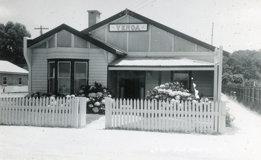
Postcard, Bulmer H D, 1945c
Enlargement of same photo 28 cm x 35 cmBlack and white postcard of Venga Guest House, Lakes Entrance, Victoria, showing weatherboard clad building, gable roof, veranda across half front, picket fence on Esplanade boundary.guesthouses, architecture, fences -
 Lakes Entrance Regional Historical Society (operating as Lakes Entrance History Centre & Museum)
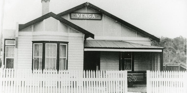
Postcard, Bulmer H D, 1940c
Black and white photo of Venga Guest House, Lakes Entrance, Victoria, showing front of guest house with signage, fenced garden, small veranda over front door, front bay window, side lane.Miss B M Hansen's Guest Houseguesthouses, architecture, fences -
 Lakes Entrance Regional Historical Society (operating as Lakes Entrance History Centre & Museum)
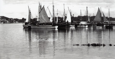
Photograph - Western Harbour, Bulmer H D, 1940c
Black and white photograph of the western harbour. It shows a variety of vessels, including auxilliary yachts and motor launches. In the background, part of the New Works area on the south shore includes Signal Flagstaff, Harbour Engineers House and Pilots House. In foreground part of rock groyne built originally to control sand buildup. Lakes Entrance VictoriaThe Boat Haventownship, waterfront, boats and boating -
 Lakes Entrance Regional Historical Society (operating as Lakes Entrance History Centre & Museum)
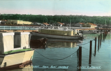
Postcard - Boat Harbour, Bulmer H D, 1940c
Colour postcard of Esplanade. It shows the boat harbour at the western end of Cunninghame Arm. Launches pictured at moorings, residential houses shown on Esplanade. Thick vegetation on Kalimna Heights escarpment in background, with glimpse of Holiday Inn. Lakes Entrance VictoriaEsplanade from Boat Harbour Lakes Entrancehouses, waterfront, boats and boating -
 Lakes Entrance Regional Historical Society (operating as Lakes Entrance History Centre & Museum)
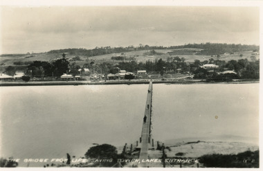
Postcard - Footbridge, Bulmer H D, 1940c
Black and white small format postcard of the footbridge over Cunninghame Arm, taken from the Royal lifesaving tower. Three people on footbridge, town beyond North Shore. Lakes Entrance VictoriaThe bridge from lifesaving tower Lakes Entrancebridges, waterways, township -
 Lakes Entrance Regional Historical Society (operating as Lakes Entrance History Centre & Museum)
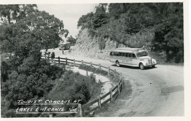
Postcard - Transport, Bulmer H D, 1960c
1 other copyBlack and white postcard of a bend in the Princes Highway at Jemmys Point. It shows two tourist coaches on the road between the steep road cutting and the post and rail fence, gravel footpath on road side of fence. Man directing traffic. Lakes Entrance VictoriaTourist coaches at Lakes Entrance, Victourism, transport, roads and streets -
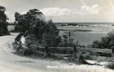 Lakes Entrance Regional Historical Society (operating as Lakes Entrance History Centre & Museum)
Postcard, Bulmer H D, 1920c
Black and white copy same sizeTinted postcard of a bend in the Princes Highway, Jemmys Point. It shows the road between the steep cutting and post and rail fence. Glimpse of footbridge to Bullock Island, entrance and hummocks. Lakes Entrance VictoriaPrinces Highway, Lakes Entrance topography, waterways, roads and streets -
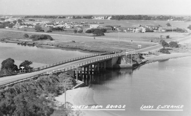 Lakes Entrance Regional Historical Society (operating as Lakes Entrance History Centre & Museum)
Photograph, Bulmer H D, 1945c
Notes: Club Hotel spit has not yet been formed. Also Postcard 8.5 x 13.5Black and white photograph of the North Arm Bridge, It shows the reinforced concrete bridge over the North Arm, and a rear view of other notable buildings. In the background sand hummocks. Lakes Entrance Victoriabridges, topography, township -
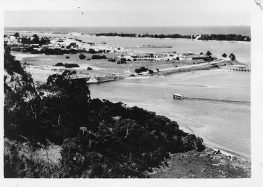
 Lakes Entrance Regional Historical Society (operating as Lakes Entrance History Centre & Museum)
Postcard, Bulmer, H D, 1940c
One Black and White Photograph 6.5 x 11|Two Postcard 8.5 x 14|Two Small format postcard 6 x 9|This is the before paired photograph used in the 150 year, Lakes Entrance 1858-2008 display.|The after paired photograph number is 01156.1 Also one 12 x 16 framed photograph used in room display.Black and white photographic card of a series of miniature cards used for souvenirs other subject, west side of township, Kalimna Hill, trees, sand hummock views. North Arm bridge and the continuing sealed highway leading around to town. Lying in the distance is the Southern Ocean. Lakes Entrance Victoriatownship, bridges, room display -
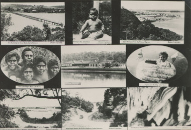 Lakes Entrance Regional Historical Society (operating as Lakes Entrance History Centre & Museum)
Postcard - Scenes from around Lakes Entrance and Lake Tyers, H D Bulmer, 1930c
Includes Club Hotel, Jemmys Point , Footbridge , Buchan Caves Black and white collage postcard showing views of Lakes Entrance, Buchan and Lake Tyers Station residents to advertise local area East Gippsland Victoriasettlement, buildings, community facilities, aboriginal history -
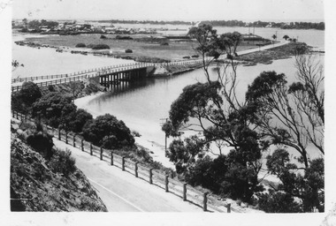
 Lakes Entrance Regional Historical Society (operating as Lakes Entrance History Centre & Museum)
Postcard, Bulmer H D, 1950c
3 Identical small format postcards 9 x 14Black and white small format postcard showing the town, North Arm bridge, Cunninghame Arm, sand hummocks, boat harbour, tourist launch approaching North Arm, power poles on lower side of road cutting. Lakes Entrance VictoriaLakes Entrance from Jemmys Pointbridges, township -
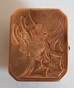 Linton and District Historical Society Inc
Cuff Link, W 15 D on reverse side
Cuff link owned and worn by Colin Kerr.Small, rectangular, brass cuff link with leaf pattern, inscribed with initials "GLS", two links of a chain attached to a ring at the back.colin kerr, cuff links, jewellery -
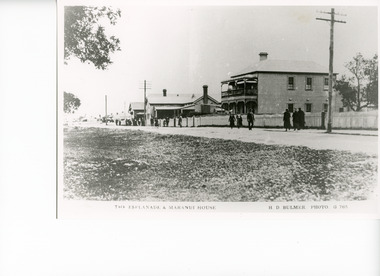 Lakes Entrance Regional Historical Society (operating as Lakes Entrance History Centre & Museum)
Photograph, Bulmer H D, 1920c
Copied from photographic copy purchaed from East Gippsland Historical SocietyBlack and white photograph of the Esplanade, showing Maranui House, a double storied weatherboard building with hipped roof, balcony over veranda at front. Picket fence across front, men and women in winter fashion on footpath. Other buildings in photo are Police Station and Bellevue Guest House. Lakes Entrance VictoriaThe Esplanade and Maranui Houseguesthouses, township, architecture, clothing, fences -
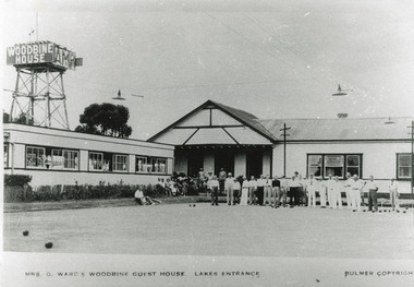 Lakes Entrance Regional Historical Society (operating as Lakes Entrance History Centre & Museum)
Photograph, Bulmer H D, 1950c
Also enlargement 28 x 35|This is the paired before paired photograph used in the 150 year, Lakes Entrance 1858-2008 display.|The after paired photograph number is 01230.1|Also one 12 x 16 framed photograph used in room displayBlack and white photograph water tank stand with signage 'Woodbine House', showing lawn used as original, bowling green. Several male bowlers and lady onlookers. Lights above green. Games room on west of main building. Lakes Entrance VictoriaMrs G Ward's Woodbine Guesthouse, Lakes Entrance. Bulmer Copyrightguesthouses, recreation, room display -
 Lakes Entrance Regional Historical Society (operating as Lakes Entrance History Centre & Museum)
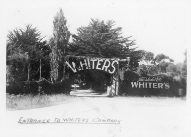
Postcard, Bulmer H D, 1945c
One of a set of eight small format postcardsBlack and white small format postcard taken from road, showing entrance, treed with signage above double gated driveway at Whiters Camp Park. Sign on fence at eastern side of gateway, Still Australia's Best. Lakes Entrance VictoriaEntrance to Whiters Camp Parkresort, tourism, recreation -
 Lakes Entrance Regional Historical Society (operating as Lakes Entrance History Centre & Museum)
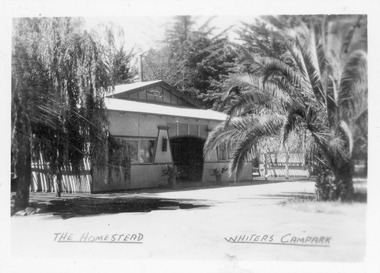
Postcard, Bulmer H D, 1945c
One of a set of eight small format postcardsBlack and white small format postcard of the Homestead at Whiters Camp Park. A fibro cement sheet clad residence of the proprietors family, palm tree at the right hand side. Lakes Entrance VictoriaThe Homestead, Whiters Camp Parkresort, recreation, tourism