Showing 2474 items matching " township"
-
 Lakes Entrance Historical Society
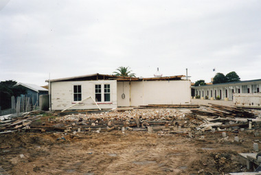
Photograph - Glenara development, Holding M, 2002c
Colour photograph showing area that will become rear carpark facing Marine Parade of Glenara Motel, Lakes Entrance, Victoriamotels, township, tourism, rsl clubs -
 Clunes Museum
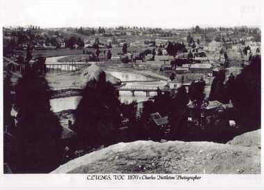
Photograph - PHOTOGRAPH CLUNES 1870, C. NETTLETON
BLACK AND WHITE PANORAMIC VIEW OF CLUNES 1870local history, clunes landscape, township, photograph clunes -
 Lakes Entrance Historical Society
Photograph - Businesses Esplanade Lakes Entrance 1960, 1960c
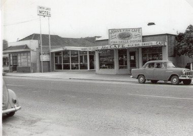
There was Billiard parlour down that end of town in the early 50’s. in Carstairs Ave. Rosmary Kavadis father (John Kostantinidis) owned it and it held 2 big tables 12 x 6 and the main games played were snooker and billiards. On the corner of Cairstairs Ave opposite Robin Hood Inn. The cafe Duckin, Mr and Mrs Kostantinidis bought it and on the side of that cafe down a verandah was the Billiard Room. It was very popular and a lot of the locals would play there. Rosemary was about 5 - 7 years old and had to stand on a fish box to play. It was very popular and next door was the Bamboo Coffee Shop run by Mr and Mrs Varney The'Duckin' became Peels bait shop Dot and Con Coucoulas took over the Bamboo and turned it into a motel not sure on the year and then bought the Duckin and demolished it. It was after Tween Lakes was built in 1959, as that was the first motel in town .The first 20 units and restaurant were built in 1959 with firsts guests on Dec. 22nd.1959. The units 21-27 plus the front residence and office were built in 1962.Black and white photograph of a short section of the Esplanade, which shows a bait shop, Bamboo Cafe, Tween Lakes Motel and John's Fish Cafe. A 1950c Holden sedan parked in front of fish shop. Rear of Volkswagon Beetle car lower lefthand corner of photo. Lakes Entrance Victoriatownship, transport, tourism, restaurant -
 Lakes Entrance Historical Society
Photograph - Whiter's Camp Park, 1928c
Also postcard size black and white same scene but larger view with two vehicles, with inscription-General view Lakes camping park showing homestead.|Larger copy has the inscription Beautiful view of park from Whiters Lookout Tower.Black and white photograph of Whiters Park, showing residence and office, gardens, tennis court, early model car by the petrol bowser, electric lights on tall poles. Opposite park entry is Aults Motor Engineer, scattered cottages. In distance is Cunninghame Arm, sand hummocks and ocean. Lakes Entrance Victoriaresort, township, transport, recreation -
 Lakes Entrance Historical Society
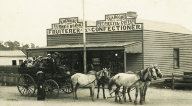
Postcard - Hennings Tea Room, 1910c
Horse drawn wagon in front of Hennings Tea RoomsBlack and white postcard showing R Hennings Tea Rooms Fruitier and Confectioner Lakes Entrance Victoria township, roads and streets, businesses, transport -
 Lakes Entrance Historical Society
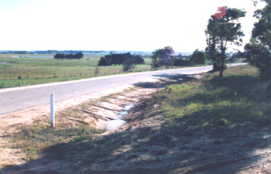
Photograph, Punt Road Metung Victoria, 1/06/1999 12:00:00 AM
Also a colour photograph looking South from Punt Road Metung 04460.1 10 x 15 cmColour photograph looking Northwest from Punt Road Metung Victoria. Also a colour photograph looking South from Punt Road Metung township, waterways, boats and boating, boardwalk -
 Lakes Entrance Historical Society
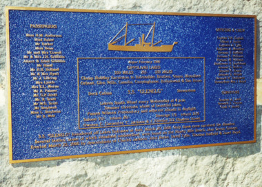
Photograph - The "Glenelg" Lakes Entrance, 25/3/2000
The "Glenelg" sank off the coast of 90 mile beach after leaving Lakes Entrance with the loss of 37 lives, only three survived. The passengers had embarked on a cruise to the lakes. It was announced on the Evening News when the wreck of the Glenelg was found 100 years later. LERHS has reference material on the inquest collected and donated by Ian Boyd whose grandmother was Stewardess aboard the GlenelgHistoricalColour photograph of memorial plaque on bluestone plinth on walkway beside Cunninghame Arm in memory of the lives lost on the wreck of the SS Glenelg Lakes Entrance Victoria. Also colour photographs taken at the unveiling of the memorial plaque by descendants of those lost on the "Glenelg" which sank on 25th March 1900. Named: Phyllis and Ian Boyd; Jeanne Davidson great granddaughter of Hilda Anderson; Aileen Knox, Ian Boyd, Elinor Boyd, Janet Gilbert, great grandchildren of Janet Boyd (Stewardess )who was lost on the Glenelg. Also two colour photographs taken when the Glenelg wreck was discovered off 90 mile beach 100 years after it was lost, showing divers who found the wreck, and announcer from TV News making the announcement. township, waterfront, shipwrecks, memorials -
 Lakes Entrance Historical Society
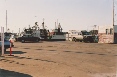
Photograph - Eastern Wharf Lakes Entrance, M Holding, 2006
Unloading area Eastern Wharf showing boats moored and vehicles parked on loading bay Lakes Entrance Victoria. Also a colour postcard of fishing boats moored at eastern extension of Eastern Wharf Cunninghame Arm footbridge in background Inscription Some of the Fishing fleet at the Fish Wharf Lakes Entrance Vic 04262.1 10 x 15 cmColour photograph of unloading area Eastern Wharf showing boats moored and vehicles parked on loading bay Lakes Entrance Victoria. Also a colour postcard of fishing boats moored at eastern extension of Eastern Wharf Cunninghame Arm footbridge in background Inscription Some of the Fishing fleet at the Fish Wharf Lakes Entrance Victoria,.boats and boating, boardwalk, township, waterways -
 Lakes Entrance Historical Society
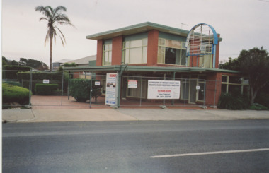
Photograph - Pelican Motel, M Holding, Esplanade Lakes Entrance Victoria, 1/06/2014 12:00:00 AM
Motel originally known as Tween Lakes started by Johnny Kostantinidis, Rosemary Kavadis' fatherColour photograph of a brick building on Esplanade recently in business as Pelican Motel showing it closed surrounded by security fence with two large notices seeking expression of interest from tenants or investors Lakes Entrance Victoria roads and streets, township, motels, businesses -
 Lakes Entrance Historical Society
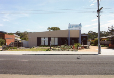
Photograph - Kiora Guest House Site, 2008
The pharmacy building has since been removed from this site, it is now vacant. The pharmacy is now situated in the Safeway Arcade.Colour photograph of the pharmacy situated in a temporary building on Esplanade. This site was originally the Kiora Guesthouse. Lakes Entrance Victoriaarchitecture, township, tourism, room display -
 Lakes Entrance Historical Society
Photograph, 1979
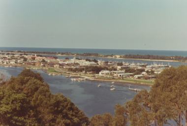
. Boats moored in North Arm and at jetties, .Taken during King of the Straits power boat race April 1979Colour photograph taken from Kalimna Heights of town between North Arm and Cunninghame Arm. Boats moored in North Arm and at jetties. Also two colour photographs of boats competing in King of Straits Power boat race, Lakes Entrance Victoria waterways, boat ramp, boats and boating, township -
 Lakes Entrance Historical Society
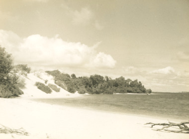
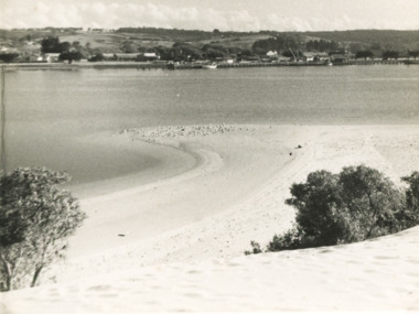
Photograph - Sand hummocks Lakes Entrance Victoria c1952, L Carpenter, 1952 c
Black and white photograph of an area of the sand hummocks known locally as Hill 60 Sandy beach and lake in foreground Lakes Entrance Victoria. Also two black and white photographs taken from sand hummocks looking west down Cunninghame Arm c1952 township, topography, gippsland lakes, sand dunes -
 Lakes Entrance Historical Society
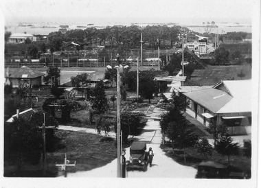
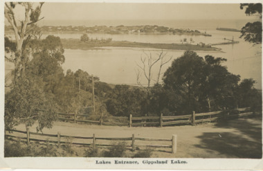
Photograph - Sand hummocks Lakes Entrance c1950
Black and white photograph taken from the sand hummocks looking across Cunninghame Arm waterway to jetties and buildings along Esplanade Lakes Entrance c1950 . Also three photographs taken from similar location looking over waterway waterways, vegetation, houses, township -
 Lakes Entrance Historical Society
Book, LERHS, Articles from Vagabond Country, 2010
Folder of publication Vagabond Country by Michael Cannon focusing on East Gippsland Victoriatownship, timber industry, tourism, waterways -
 Lakes Entrance Historical Society
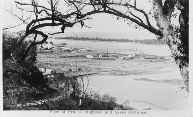
Postcard, H D Bulmer, Princes Highway Lakes Entrance Victoria, c1930
Black and white postcard showing part of Princes Highway below Jemmys Point, undeveloped Bullock Island New Works area and Entrance in distance Lakes Entrance VictoriaLakes Entrance Gippsland Lakesroads and streets, transport, township, waterways -
 Lakes Entrance Historical Society
Postcard - Views of Lakes Entrance c1972, 1972 c
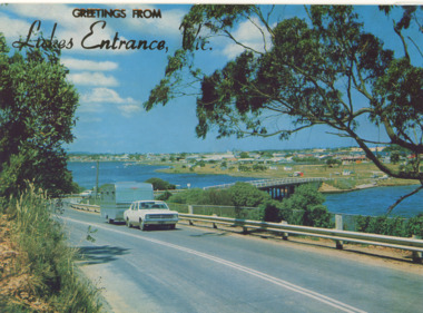
Princes Highway looking down to North Arm bridge with town in distance, people camped on North Arm foreshore and car towing caravan in foreground Lakes Entrance VictoriaColour postcard taken from Princes Highway looking down to North Arm bridge with town in distance, people camped on North Arm foreshore and car towing caravan in foreground Lakes Entrance VictoriaGreetings from Lakes Entrancebridges, roads and streets, township, vehicles -
 Port of Echuca
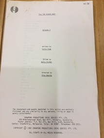
Document - Television script, Crawford Productions, All the Rivers Run Episode 3, 1982
This original script was from a television mini series titled 'All The Rivers Run' that was filmed in Echuca in 1982. The production took over the township for many months and was often filmed on board the Port of Echuca's paddle steamers.This original script from the mini series 'All the Rivers Run' is of social significance as it was filmed on location at the Port of Echuca and surrounding Echuca township. There are very few remaining scripts in existence. 70 page printed script of Episode 3 All the Rivers Run mini series 'All the Rivers Run' Episode 3 Written by Colin Free, Edited by Betty Archer, Directed by Pino Amenta. Copyright 1982 Crawford Productions Pty Ltd script, paper, miniseries, echuca, river, crawford productions, port of echuca -
 Kiewa Valley Historical Society
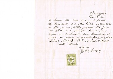
Letter Commerce, Confirmation of Payment, 02/12/1911
This document (dated 1911), is a receipt covering the compensation for the three acres of land required to establish the Tawonga School from its original site (since 1880) to a more central site (since 1911), within the township. This receipt clearly shows the era in which the community involvement and social commitment of landholders was at a higher level, in the early 20th century, than at the latter part. Matters involving community welfare in relatively isolated rural regions was of high priority to every person whether town folk or grazier/farmer or miner. The letter of acceptance of the amount of twenty one pounds for three acres was signed by John Cooper on behalf of Ada Ryder (parent at the school), did not require State Government Compulsory Acquisition process (as it may have, had it been in the latter part of the century and if it were in a city or large town. This social benevolency was part of the period (up to the late 1900's) of the rural Australian environment. This was well before international land investments changed the picture of the socio-economics of country towns.A4 letter of confirmation of payment on pre-lined paper and with a margin. Both margin and lines are coloured in light grey. The page has been folded four times and shows faintly, horizontal lines, of manufacture. The letter is framed with a glass front.This receipt for the compensation of money is hand written in ink and reads: "Tawonga Dec 2 1911, I have this Day Received from the Residents and other People interested in the new State School the Sum of (Pounds sign) 21-0-0 twentyone Pounds being value of compensation for three Acres of land on which is erected the new State School No.2282 Paid by Cash & Cheques with thanks 2/12/11 (Signed) John Cooper" Below this is affixed a Victoria 1 pence stamp duty stamp, on which is written(freehand) Paid 2/12/11 Initialed J Cfinancial letters, receipts, school acquisitons, stamp duty -
 Hume City Civic Collection
Photograph, Mill Falls
The photograph is of the Jacksons Creek taken in the vicinity of Mill Falls, near the former 'Springvale' winery, which was downstream from the Sunbury township. In 1971 the Shire of Bulla purchased 'Springvale' site and established the town's sewerage plant.The former 'Springvale' winery was one of a number of wineries that were established in Sunbury in the 19th century.A scanned coloured photograph with rounded corners of a valley with a meandering stream with a small dammed section in the foreground. There is a line of trees across the distant hilltops. mill falls, springvale winery, jacksons creek -
 Sunbury Family History and Heritage Society Inc.
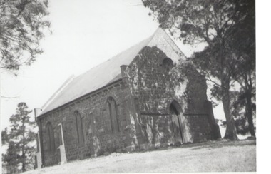
Photograph, Rosa McCall, St. Paul's Church of England, Westmeadows, 1950
The small church is St. Paul's Church of England built and opened in December 1850 in the former old Broadmeadows township, now part of Westmeadows. The original roof was built from shingles but was replaced with slate at a later date. St. Paul's Church in Westmeadows is one of the oldest original churches in Victoria.A non-digital black and white print of a small blue stone church with a slate roof set on a rise and surrounded by pine trees.st. paul's church of england, westmeadows, old broadmeadows township, churches -
Bendigo Historical Society Inc.
Map - CROSBIE : COUNTY OF BENDIGO, 1970
Map. Crosbie, County of Bendigo, County of Rodney, Toolleen, Weston, Dargile, Knowsley East, Redcastle, Township of Toolleen, Northern Highway, Mt.Pleasant Creek. By Authority R.H. Rixon, Government Printer, Melbourne. Drawn and reproduced at the Department of Lands and Survey, Melbourne. 1970. Price $1.00. (number 114 in map cupboard 1)R.H. Rixon, Government Printer, Melbourne.map, bendigo, crosbie -
 Whitehorse Historical Society Inc.
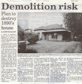
Article, Demolition risk, 28/01/1998 12:00:00 AM
Article in Whitehorse Gazette regarding a development application to replace a house in Blackburn Road built about 1890 as part of the Blackburn Model Township designed by architect Arthur Clarke. Bernadette Cahill who lives next door is interviewed as is Whitehorse City Council's acting Statutory and Development Manager, John Lupins. Photograph.blackburn road, blackburn, cahill, bernadette, blackburn model township, clarke, arthur, lupin, john, city of whitehorse, residential development -
 Ballarat Tramway Museum
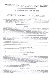
Document - Photocopy, "Town of Ballaarat East / to Contractors and Others / Construction of Tramways", 2008
Details the conditions of a tender for the construction of tramways in the town of East Ballarat - a possibility that did not occur.Three page photocopy of a tender document titled ""Town of Ballaarat East / to Contractors and Others / Construction of Tramways", in the Town of Ballaarat East, dated 7 September 1888. Gives and terms and conditions of any agreement for the construction and operation of trams in the township. Second copy added 31/5/2011 - see History of Object. trams, tramways, ballarat east, construction, tramways, tenders -
 Bacchus Marsh & District Historical Society
Map, Balliang Parish Map, County of Grant c.1907
A single page paper map showing parish plan map for Balliang. This parish area contains the localities of Balliang and Balliang East and is located south of the township of Bacchus Marsh. The map is pasted into a bound volume containing 76 maps or plans in total. High resolution digital image stored on BMDHS computer network. balliang victoria maps, balliang parish maps -
 Lakes Entrance Historical Society
Postcard - View from Jemmys Point, 1920c
Also 1x Miniature postcard 6cmx8.5cm ' A Glimpse of Lakes Entrance' 01153-4Black and white miniature photographic postcard showing the North Arm Bridge prior 1937; post and rail fence around Kalimna road; township, Club Hotel and stables; jetties in Cunninghame Arm, Methodist Church; and sand hummocks. Telegraph line around hill and across sand flat. Lakes Entrance Victoriabridges, hotels, fences, public utilities -
 Eltham District Historical Society Inc
Photograph, Margaret Ball, Stebbing's Cottage, 88 Pitt Street, Eltham, June 1999
One of the oldest houses in Eltham, the cottage was built around 1861 by pioneer builder George Stebbing whose family lived in it until the 1900s. It’s plain and simple style reflects the functional design of the house. George Stebbing was responsible for the construction of some of Eltham's principal township buildings, including the Uniting (former Methodist) church, St. Margaret's Anglican church (1861) and Shillinglaw Cottage (1879). The house is historically and aesthetically significant because it is a rare surviving example of the modest homes constructed for and by artisans within the early Eltham township and is a significant feature of the streetscape In the 1960s Albert Downing owned this propertyThe Margaret Ball (Pre 1960s Houses) Collection was a personal project initiated to mark the year 2000 and arose as a result of the disappearance of many pre-1960s parts of Eltham due to development. Approximately 200 pre-1960s style houses that were left in Eltham between Main Road and east to Bible Street, between Cecil Street to the north and south to Dalton Street were photographed in late 1999. Not all of the houses could be photographed; some because the garden or trees blocked the view of the house, others because of rubbish or cars were in the way, some because people were working on the house or in the gardens at the time.Colour photographic print eltham, houses, streets, margaret ball (pre 1960s houses) collection, pitt street, stebbing's cottage, downing -
 Warrnambool and District Historical Society Inc.
Book, Book Certificate of Titles A-Z Index, C 1890
This book contains certificates of title and Crown grants which record local changes of ownership.many are in the township of Warrnambool while others relate to areas such as Nullawarre, Purnim and Framlingham.These documents come under the Transfer of lands act of 1890.This book has many local names and properties and is an historic link for the district.Brown heavy card cover with red fabric binding. It has an alphabetical index at the front followed by 200 pages of certificates of title.Descriptions of the land is written at the top of the pages with drawn and coloured diagrams below. The dates range from C 1878 to to C 1966. Some are certificate of title and others are Crown Grant. warrnambool, certificate of titles warrnambool 1900 -
 Warrnambool and District Historical Society Inc.
Book, Description & plans of title & grants
This book contains certificates of title and Crown grants which record local changes of ownership.many are in the township of Warrnambool while others relate to areas such as Nullawarre, Purnim and Framlingham. These documents come under the Transfer of lands act of 1890.The significance of this book lies in the many names and the land to which they were connected. Deep maroon paper over card cover with dark green fabric binding.Alphabetical index at the front followed by 200 pages which record details of the Certificates of title and Crown Grants from around the period of warrnambool, warrnambool history, certificate of title, crown grant warrnambool -
 Marysville & District Historical Society
Map (Item) - Tourist map, Murrindindi Shire Council, VISITOR INFORMATION & MAP LAKE MOUNTAIN, MARYSVILLE & TRIANGLE, 02-2010
A visitor information map for Lake Mountain, Marysville and the local district produced by the Murrindindi Shire Council in February 2010. This information guide and map was produced after the 2009 Black Saturday bushfires destroyed most of the township of Marysville.A visitor information map for Lake Mountain, Marysville and the local district produced by the Murrindindi Shire Council in February 2010.Murrindindi Shire Council has made every effort to ensure the information provided at the time/ of printing is correct, but accepts no responsibility for an inaccuracies or omissions.lake mountain, marysville, victoria, australia, visitor information & map, murrindindi shire council, big 4 holiday park taggerty, black spur inn, black spur motel & caravan park, bush creek buddha, buxton hotel motel, cathedral valley farm, chestnut glade, crossways historic country inn, delderfield luxury b&b, kingbilli country estate, marapana agistment park & farm stay b&b, maryton park b&b, pinjarra gardens, sarsens rest, silverstream b&b, tower motel, willowbank at taggerty, wombat cottage, woodlands rainforest retreat, buxton general store and post office, buxton zoo nursery, cathedral view natural therapies, country touch, cross country ski hire, foodworks, highwood health retreat, lake mountain ski hire, lit & beyond, lj hooker, maroondah outdoor equipment/bait & tackle, marysville medical centre, marysville patisserie, marysville ski centre, marysville triangle real estate, marysville visitor information centre, mystic mountains ski hire/outdoors, pat's hairdressing, penni lanes country wares, plant's by shelian -
 Trentham and District Historical Society
Book - Log book, Observers Log - Volunteer Air Observers Corps
Used during WW2. Trentham Air Observers Corps logbook of plane traffic spotted from Cranney's Hill lookout. The lookout was located one mile east of Trentham township. The Observers were volunteers, mainly women.Foolscap sized book with brown paper cover. Hand-written entries.trentham, volunteer air observers corps, spotters, cranney's hill, shirley trewella, gamble, world war 2, home front, log-book