Showing 6018 items
matching 21
-
 Ballarat Tramway Museum
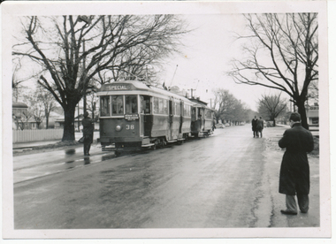
Photograph - Digital image, Keith Kings, 20/08/1955 12:00:00 AM
Yields information about the trams used by the AETA for a Ballarat tour to celebrate the Golden Jubilee of electric trams.Digital image from the Wal Jack Ballarat Album of the AETA Ballarat Golden Jubilee tour of 20/8/1955, of Specials 21 and 38, in Ripon St at near Sturt St, on View Point line. Photograph by Keith Kings. See image i2 for rear of photograph. i3 - hi res scan of print i4 - cleaned image by PCW - 22-9-2022On rear of photograph in ink "Ballarat Golden Jubilee of electric trams, Specials 21 & 38, in Ripon St at Sturt ST on View Point line. 20/8/1955" and Keith Kings stamp in top right hand corner with number "P(c)(4)" written in.trams, tramways, aeta, tours, golden jubilee of trams, ripon st, view point, tram 21, tram 38 -
 Phillip Island and District Historical Society Inc.
book, Portrait of Elmbury, 1946
hardback, 21 x 15 x 2 mm, dull red cloth binding.Himmer Bequest ; formerly Cowes Municipal Public Library -
 Kew Historical Society Inc
Book, Pharmaceutical Society of Great Britain, British Pharmaceutical Codex, 1963
xxxvi, 1433 p. : ill. ; 23 cm. + booklet ([16] p. ; 21 cmnon-fictiondispensatories., pharmacology -
University of Melbourne, Burnley Campus Archives
Newspaper - Newspaper Cutting, The Victorian Farmers Journal and Gardeners Chronicle, The New Gardens of the Horticultural Society, 1862
Advises lithograph of the new gardens is included. They had hoped to open the gardens on 1st january, 1862 but had insufficient funds to complete the work. Description of grounds.Photocopy of article in "The Victorian Farmers Journal and Gardeners Chronicle" 21 June, 1862 p13. the victorian farmers journal and gardeners chronicle, lithograph, gardens -
University of Melbourne, Burnley Campus Archives
Album - Black and white prints and negatives, Burnley Open Garden, 1991
21 photographs of people at the Burnley Open Garden 1991. Probably taken by a staff memberburnley, open garden, 1991 -
Koorie Heritage Trust
Book, Beauglehole, A. C, The distribution and conservation of vascular plants in the Murray Valley area, Victoria, 1986
ii, 81 p. : ill., maps ; 21 x 30 cm. + col. map.botany -- murray river valley (n.s.w.-s.a.) -
Koorie Heritage Trust
Book, Beauglehole, A. C, The distribution and conservation of vascular plants in the south west area, Victoria, 1984
iv, 124 p. : ill., maps (some col.) ; 21 x 29 cm.botany -- victoria, southwestern. -
University of Melbourne, Burnley Campus Archives
Album - 35mm Colour slides, High Altitude Trees
21 slides of trees at high altitudes. 1,100-2,500m. Possibly China trip. No date.trees, high altitudes, arboriculture -
 Kew Historical Society Inc
Book, Herald & Weekly Times, One Hundred Years: the romance of the Victorian people, 1934
Originally written as series of articles in connection with the Centenary of Victoria.Melbourne : Herald & Weekly Times, 1934 432 p. : ill., ports. ; 21 cm. non-fictionOriginally written as series of articles in connection with the Centenary of Victoria. victoria - history -
 Eltham District Historical Society Inc
Slide - Photograph, Unidentified artwork; stained glass leadlight
Unidentified artworks35mm colour positive transparency (21) Mount - Kodak Ektachrome Blue Verycolour MelbourneIn a box marked Set B Norm. LHS RHSleadlight, stained glass, artwork -
 Eltham District Historical Society Inc
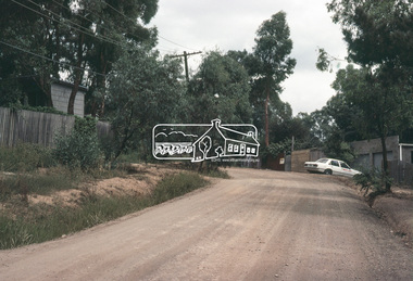
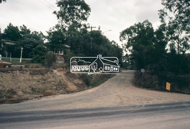
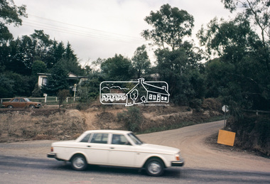
Slide, Adam Crescent, Montmorency, c. Feb. 1981
One of a series of images of road infrastructure focussed on Adam Crescent in Montmorency taken by Eltham Shire Council Planning and Engineering officers. They provide perspective of the changes in housing styles and road development that began sweeping in from the mid 1970s with increasing urbanisation of what was once more outlying suburbs and regions. All images have been identified with GPS though house numbers have changed35 mm colour positive transparency (1 of 21) Mount - Kodak Kodachrome CardProcessed Feb 1981adam crescent, infrastructure, montmorency, roads -
 Eltham District Historical Society Inc
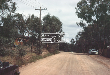
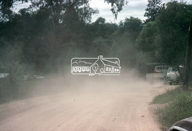
Slide, Adam Crescent, Montmorency, c. Feb. 1981
One of a series of images of road infrastructure focussed on Adam Crescent in Montmorency taken by Eltham Shire Council Planning and Engineering officers. They provide perspective of the changes in housing styles and road development that began sweeping in from the mid 1970s with increasing urbanisation of what was once more outlying suburbs and regions. All images have been identified with GPS though house numbers have changed35 mm colour positive transparency (1 of 21) Mount - Kodak Kodachrome CardProcessed Feb 1981adam crescent, infrastructure, montmorency, roads, gordon grove -
 Eltham District Historical Society Inc
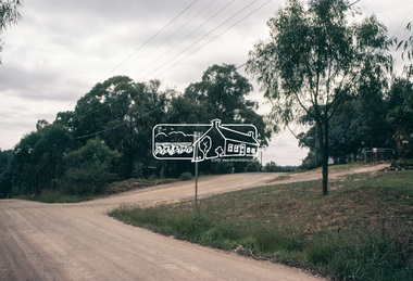
Slide, Adam Crescent, Montmorency, c. Feb. 1981
One of a series of images of road infrastructure focussed on Adam Crescent in Montmorency taken by Eltham Shire Council Planning and Engineering officers. They provide perspective of the changes in housing styles and road development that began sweeping in from the mid 1970s with increasing urbanisation of what was once more outlying suburbs and regions. All images have been identified with GPS though house numbers have changed35 mm colour positive transparency (1 of 21) Mount - Kodak Kodachrome CardProcessed Feb 1981adam crescent, infrastructure, montmorency, roads -
 Eltham District Historical Society Inc
Slide, Adam Crescent, Montmorency, c. Feb. 1981
One of a series of images of road infrastructure focussed on Adam Crescent in Montmorency taken by Eltham Shire Council Planning and Engineering officers. They provide perspective of the changes in housing styles and road development that began sweeping in from the mid 1970s with increasing urbanisation of what was once more outlying suburbs and regions. All images have been identified with GPS though house numbers have changed35 mm colour positive transparency (1 of 21) Mount - Kodak Kodachrome CardProcessed Feb 1981adam crescent, infrastructure, montmorency, roads, gordon grove -
 Eltham District Historical Society Inc
Slide, Adam Crescent, Montmorency, c. Feb. 1981
One of a series of images of road infrastructure focussed on Adam Crescent in Montmorency taken by Eltham Shire Council Planning and Engineering officers. They provide perspective of the changes in housing styles and road development that began sweeping in from the mid 1970s with increasing urbanisation of what was once more outlying suburbs and regions. All images have been identified with GPS though house numbers have changed35 mm colour positive transparency (1 of 21) Mount - Kodak Kodachrome CardProcessed Feb 1981adam crescent, infrastructure, montmorency, roads -
 Eltham District Historical Society Inc
Slide, Adam Crescent, Montmorency, c. Feb. 1981
One of a series of images of road infrastructure focussed on Adam Crescent in Montmorency taken by Eltham Shire Council Planning and Engineering officers. They provide perspective of the changes in housing styles and road development that began sweeping in from the mid 1970s with increasing urbanisation of what was once more outlying suburbs and regions. All images have been identified with GPS though house numbers have changed35 mm colour positive transparency (1 of 21) Mount - Kodak Kodachrome CardProcessed Feb 1981adam crescent, infrastructure, montmorency, roads, gordon grove -
 Eltham District Historical Society Inc
Slide, Adam Crescent, Montmorency, c. Feb. 1981
One of a series of images of road infrastructure focussed on Adam Crescent in Montmorency taken by Eltham Shire Council Planning and Engineering officers. They provide perspective of the changes in housing styles and road development that began sweeping in from the mid 1970s with increasing urbanisation of what was once more outlying suburbs and regions. All images have been identified with GPS though house numbers have changed35 mm colour positive transparency (1 of 21) Mount - Kodak Kodachrome CardProcessed Feb 1981adam crescent, infrastructure, montmorency, roads -
 Eltham District Historical Society Inc
Slide, Adam Crescent, Montmorency, c. Feb. 1981
One of a series of images of road infrastructure focussed on Adam Crescent in Montmorency taken by Eltham Shire Council Planning and Engineering officers. They provide perspective of the changes in housing styles and road development that began sweeping in from the mid 1970s with increasing urbanisation of what was once more outlying suburbs and regions. All images have been identified with GPS though house numbers have changed35 mm colour positive transparency (1 of 21) Mount - Kodak Kodachrome CardProcessed Feb 1981adam crescent, infrastructure, montmorency, roads, gordon grove -
 Eltham District Historical Society Inc
Slide, Adam Crescent, Montmorency, c. Feb. 1981
One of a series of images of road infrastructure focussed on Adam Crescent in Montmorency taken by Eltham Shire Council Planning and Engineering officers. They provide perspective of the changes in housing styles and road development that began sweeping in from the mid 1970s with increasing urbanisation of what was once more outlying suburbs and regions. All images have been identified with GPS though house numbers have changed35 mm colour positive transparency (1 of 21) Mount - Kodak Kodachrome CardProcessed Feb 1981adam crescent, infrastructure, montmorency, roads, sherbourne road -
 Eltham District Historical Society Inc
Slide, Adam Crescent, Montmorency, c. Feb. 1981
One of a series of images of road infrastructure focussed on Adam Crescent in Montmorency taken by Eltham Shire Council Planning and Engineering officers. They provide perspective of the changes in housing styles and road development that began sweeping in from the mid 1970s with increasing urbanisation of what was once more outlying suburbs and regions. All images have been identified with GPS though house numbers have changed35 mm colour positive transparency (1 of 21) Mount - Kodak Kodachrome CardProcessed Feb 1981adam crescent, infrastructure, montmorency, roads, sherbourne road