Showing 1945 items
matching 66
-
 Flagstaff Hill Maritime Museum and Village
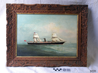
Painting - Vessel, C.K.M. (artist), S.S. Warrnambool, 1883
This oil painting is in a handmade, carved frame, dates back to the period of the old Warrnambool Museum and Art Gallery. The two-masted, sail-and-steam-powered ship has the sails and bow shape of a tall clipper ship plus the extra power of steam. It dates to the transition between the clipper ships with their billowing sails and the steam-powered ships, which happened in the late 19th to early 20th century. The flag flown from the stern is that of the British Merchant Navy that traded around the world to transport cargo, and later passengers, from one destination to another. The painting was originally catalogued as the "S.S. Warrnambool" although it has a different design. It was also attributed to the ship portrait painter, the renowned C.K.M. - Charles Keith Miller - but differs from his style. Further research is being carried out at this time. In 1966, between the closure of the old Warrnambool Museum and Art Gallery and the distribution of the painting to Flagstaff Hill, this painting was repaired by David Heysen, son of the German-born artist Hans Heysen OBE. David was born in Hahndorf (called Ambleside for a short period of time), South Australia, married Lyly Refshauge from Melbourne, and they raised a family on their property in Kalangadoo, near Penola, in South Australia.The painting's frame is an example of handmade carving and joinery created in the late 19th century. The artist has depicted the image of a historical sail-and-steam ship of the type in which cargo was traded across the world, including to and from Australia. Vessels such as this also brought migrants to Australia.Painting, oil on board, in hand carved wooden frame with floral and geometric pattern, inner border painted gold. Image of a two-masted sail and steam ship, sails raised, black funnel emitting smoke. Hull is black with white horizontal stripe and white trim around sides of deck. Three lifeboats are visible. Bow is ‘clipper shape’ with what appears to be a figurehead. A red ensign flag flies at the stern and a blue and red flag is attached to the mainmast. The frame has been assembled using Mortice and Tenon joints, one of which is exposed on the back, lower right corner. Chandelier chain has been attached for hanging. There is no visible signature, date or title on the front of the painting. The back board has empty holes spaced around the edge and is held in place by staples. The visible surface has remnants of adhesive from two rectangular attachment s. There are two small white stickers attached, one with a hand written inscription. There are pencil and pen inscriptions. The painting is protected by cardboard with inscriptions in marking pen.On back board, written in the style used by the Warrnambool Museum and Art Gallery: - On white sticker, in pen “A-P31/1-74” - Pencil “A27/1883 / Artist CKM 1883 / Title SS Warrnambool / oil on board” Written in pen by the repairer - “Repaired & re-drilled – cleaned etc. / David Heysen 11/66” Written by Flagstaff Hill’s Cataloguer - Pencil “3031” On cardboard wrapper, in marking pen: - “S.S. Warrnambool / by / C.K.M. 1883” - “A-P/31/1-74” - “3031”flagstaff hill, warrnambool, shipwrecked coast, maritime museum, shipwreck coast, flagstaff hill maritime village, great ocean road, s s warrnambool, charles keith miller, charles miller, steam and sail ship, british merchant navy, slipper shaped bow, 19th century sea trade, warrnambool museum and art gallery, old warrnambool art gallery, hand carved picture frame, mortice and tennon picture frame, migrants, c.k.m. -
 Wodonga & District Historical Society Inc
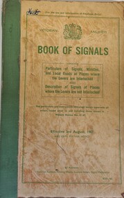
Manual - Victorian Railways Book of Signals, Victorian Railways Printing Works, 1967
This manual was issued by Victorian Railways in 1967 to explain all of the railway signals used throughout Victoria. It included a detailed outline of the signals used at every railway station, including small depots and sidings throughout Victoria. Illustrations of the different signal systems are included in the text. Every driver, fireman, guard, shunter, and every other employee designated by the Head of the Branch concerned, had to be supplied by his superior officer with a copy of this book. They were required to become thoroughly acquainted with the particulars which related to their duties. The included informations was effective from 3rd August, 1967 until further notice.A beige coloured book with green binding. The cover includes the Royal Coat of Arms, a summary of the purpose and contents of the manual, and the date the instructions become effective, all printed in green ink. This information is enclosed by a green border. non-fictionThis manual was issued by Victorian Railways in 1967 to explain all of the railway signals used throughout Victoria. It included a detailed outline of the signals used at every railway station, including small depots and sidings throughout Victoria. Illustrations of the different signal systems are included in the text. Every driver, fireman, guard, shunter, and every other employee designated by the Head of the Branch concerned, had to be supplied by his superior officer with a copy of this book. They were required to become thoroughly acquainted with the particulars which related to their duties. The included informations was effective from 3rd August, 1967 until further notice.victorian railways, victorian railways -- rules and practice., railway signals -
 Melbourne Tram Museum
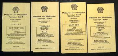
Ephemera - Timetables - MMTB trams - set of 10, Melbourne & Metropolitan Tramways Board (MMTB), 1973
MMTB Timetables - providing information on ticketing, fares, and timing points, with a description of the route and a map. Includes routes via William St - in the 30s 1 - East Malvern - City - route 3, bus route on Sundays only - June 1973 2 - Malvern Burke Road - City - route 5 and 35, - June 1973 3 - Glen Iris - City - route 6 and 36 - Sept. 1973 4 - Toorak - City - route 8 and 38 - June 1973 5 - South Melbourne and St Kilda Beach - City - routes 10, 12, and 17 - June 1973 6 - St Kilda Beach - South Melbourne Beach - City - routes 15, 16, 53, 55, 1, 2 and 4 - Sept. 1973 7 - Moreland - East Coburg - City - routes 1, 21, 15 and 22 - August 1973 8 - East Brighton - City - routes 64, 65, 62 and 61 - June 1973 9 - Carnegie - City routes 67, 37 and 66 - June 1973 10 - Kew Cotham Road - St Kilda Beach - route 69 - June 1973Yields information about MMTB tram services during 1973Set of 10 MMTB tram timetables - multifolded printed on yellow paper.timetable, mmtb, glen iris, malvern town hall, toorak, route 36, route 8, route 38, route 10, route 12, route 17, route 3, route 5, route 35, route 6, route 1, route 2, route 4, route 21, route 15, route 22, route 64, route 65, route 61, route 62, route 67, route 37, route 66, route 69 -
 Melbourne Tram Museum
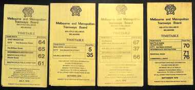
Ephemera - Timetables - MMTB trams - set of 8, Melbourne & Metropolitan Tramways Board (MMTB), 1976
Timetables - provide information on ticketing, fares, and timing points, with a description of the route and a map. Not all services had been allocated a route number at the time. 1 - East Brighton - City and via William St - routes 64, 65, 62 and 61 - July 1976 2 - Malvern (Burke Rd) to City and via Wiliam St - routes 5 and 35 - Oct. 1976 3 - Carnegie - City and via William St - routes 67, 37, and 66 - July 1976 4 - Wattle Parke - City and Camberwell depot - routes 70, 71 and 76 - Sept. 1976 5 - Kew - Cotham Road to St Kilda Beach - route 69 - August 1976 6 - East Preston - via Bourke or La Trobe, and East Brunswick - routes 88, 14, 89. 90, 96, 95, and 97 - Feb. 1976 7 - Toorak - City and via William St - routes 8 and 38 - August 1976 8 - St Kilda Beach and South Melbourne Beach and via William St - routes 15, 16, 53, 55, 1, 2 and 4 - Sept. 1976 Yields information about MMTB tram services during the 1970s. Set of 8 MMTB tram timetables - multifolded printed on yellow paper.timetable, mmtb, wattle park, east brighton, malvern, carnegie, kew, east brunswick, toorak, st kilda beach, south melbourne beach, route 64, route 65, route 62, route 61, roure 5, route 35, route 67, route 37, route 66, route 70, route 71, route 76, route 69, route 88, route 96, route 8, route 38, route 15, route 1, route 2, route 55, route 53 -
 Federation University Historical Collection
Book - Ledger, Ballarat School of Mines Minute Book, 1942-1946, 03/03/1942-20/03/1946
The Ballarat School of Mines was established in 1870 and was the first School of Mines in Australasia. Blue hard covered book with brown leather spine and corners. pg 4 - Farewell for Albert W. Steane pg 9 - Instruction in Electrical Engineering pg 30 - The late Cr M. Martin pg 38 - Caretakers Duties pg 40 - The late Cr F. Barrow pg 43 - John Brittain Telescope pg 43 - Martha Pinkerton Bequest pg 66 - Resignation of Albert E. Williams pg 85 - N. Whiteside and Civil Engineering Course pg 128-130 - Technical Education pg 193 - Proposed new buildings pg 272 - Retirement of J.M. Sutherland pg 280 - Proposed change of name to school pg 297 - Woolclassing Room pg. 342 - pg 353 - D. Taylor Kellock pg 353 - Resignatin of Miss Grigg pg 367 - Dr Pern's Collections of Aboriginal Artefacts pg 377 - Inmates of Ballarat Orphanage pg 356 - Ballarat School of Mines Museum contents Loose - Resolutions Passed by Technical Schools' Association of Victoria, October, 1942, with the Minister's Replies.Pg 367 - "Dr Pern's Collection Cr Lederman reported on the proceedings of the special committee meeting held on the 19th February. At that meeting it was suggested that the Ballarat Historical Society might consider transferring their collection to the Museum. It was decided that any expert from Melbourne be invited to come to Ballarat for the purpose of inspecting the mounted birds, which in many instances were falling to pieces, and recommending the best way of dealing with them."m. grigg, t.h. trengrove, building plans, john brittain telescope, new workshops, t. barrow, a.w. steane, martha pinkerton, ballarat school of mines museum, sydney pern, pern collection, ballarat orphanage, thomas aggett, william aggett, sebastian fumberger, peter hogg, ronald irving, eric jackson, ray lear, ken mason, john birch, william gleeson, robert gleeson, robert guyas, ronald holmes, albert king, stuart smith, alan snell, martha pinkerton scholarship, frank pinkerton scholarship, thomas trengrove, d. taylor kellock, architecture course -
 Ballarat Tramway Museum
Document - Research Notes, Alan Bradley, Fare changes in Ballarat in November 1955 and August 1966, 2003
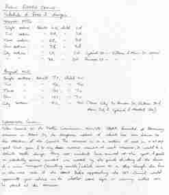
Yields information about the various fare increases in Ballarat, how they were applied and about the problems of the tram cross over in Albert St Sebastopol.1. Photocopy of handwritten notes prepared by Alan Bradley, c2002/3 on fare changes in Ballarat in November 1955 and August 1966. Gives the fares for the various sections. 1 x A4 sheet. Copy of a note from the Borough of Sebastopol to Traffic Commission 15/10/1958 about the problem of the tramline crossing Albert St, Sebastopol at and angle and the lack of appropriate warning signage. 2. E-mail from Alan Bradley, - 2 x A4 sheets dated 26/4/2003 detailing fares/sections for 11/55, 3/63, 9/66 and 1/69, other changes to fares, eg city sections and pensioners. Sheets stapled in top left hand corner. 3. E-mail from Alan Bradley - 2 x A4 sheets dated 29/5/2003 re ESCo fares, SEC tram fares in 1937, 1938, overlapping sections, 1949 fare increase, and other notes that formed the basis of the fares appendix in the Tramways of the Golden City. Sheets stapled in top left hand corner.trams, tramways, albert st, fares, tickets, sebastopol, sec, esco -
 Eltham District Historical Society Inc
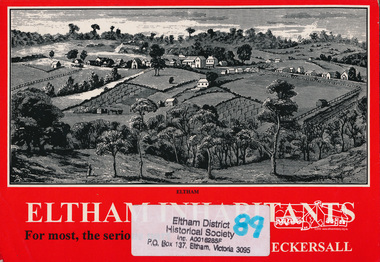
Book, Kenneth Eric Eckersall, Eltham inhabitants : for most, the serious part : church in community 1850-2000 / Kenneth Eric Eckersall, 2000
ArtStreams: Arts in Banyule, Darebin, Manningham, Nillumbik, Whittlesea & Yarra Vol. 5 No. 6 Summer Issue, 2000 Book Review "Ken Eckersall has been a member of the Eltham community for 40 years. He has been a member of the Methodist / Uniting Church for all of his 66 years. Having moved from being a compositer in the printing trade to a teacher and lecturer, in his retirement he has become an historian. Eltham Inhabitants is ostensibly a history of the Eltham Uniting Church, written to celebrate its 150th anniversary. The book is considerably broader than the commission suggests. This is hinted at in Eckersalls reference to the Eltham Wesleyan/Methodist/Uniting Church. Eckersall writes on the history and philosophy of the church from its beginnings in the 18th century to the present and places it in the context of the sociology and history of the period. Recognising the nexus between church and community, the author has in large part written a history of the Eltham community including the churches of other denomination(s). There are very few artists, academics or other interesting characters from the district who don't get a mention. Despite a plethora of information about the church, Eltham Inhabitants is a fund of historical information on many other fronts."Paperback; viii, 175 p. : ill. ; 21 cm. 2 copieseltham, churches, uniting church, eltham uniting church -
 Bendigo Military Museum
Uniform - SHIRT, TROUSERS - COMBAT DRESS ARMY, Australian Defence Industries, 2018
AMCU (Australia Multi Camouflage Uniform) Combat Dress colours - light to dark green through to mid to dark brown. Cotton/polyester fabric. Green colour plastic buttons. Nylon and metal zippers. 1. Shirt - polo style, with collar, long sleeves with adjustable velcro and strap at cuff. Two large sleeve pockets with hook and pile closure flaps, one small pocket left sleeve. Half zipper closure. Front and back of shirt - plain khaki colour knit fabric. No manufacturers label. 2. Trousers - waist band with belt loops, two front pockets, two large side pockets with zipper closure, two small pockets with hook and pile flap closure, zipper fly. White colour polyester fabric manufacturers label on right pocket lining. Green cotton fabric pocket lining. At ankle - elastic drawstring with plastic lock clip.Manufacturers information on label - black ink print. 2. "ADA/ MADE IN AUSTRALIA/ NOV 2018/ PO: CC36LD/ NSN:8415 66 161 6292/ SIZE: 34l/ 84-89 cm/^/ NAME/ PM KEYS NO:/ MAIN:/ 75% COTON/ 25% POLYESTER/ STRETCH/ 91% NYLON 9% ELASTANE/ KNEE PADS MUST BE REMOVED BEFORE/ CLEANING. HOT MACHINE/WASH. NO BLEACH/ NO FABRIC SOFTENERS/ MAY BE TUMBLE DRIED HOT/ DO NOT IRON OVER/ STRETCH PANELS OR HOOK AND PILE" .uniform, army, combat dress, amcu -
 Shepparton RSL Sub Branch
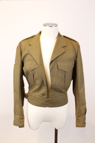
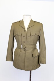
Uniform, Jacket, E.W. PTY/LTD, 1968
This jacket is part of a Royal Australian Army Ordnance Corps uniform. The Royal Australian Army Ordnance Corps (RAAOC) is responsible for various logistics and organisational operations, such as maintenance of parachutes, fuel distribution, personnel administration, exlosive disposal and laundy operations. The jacket was manufactured in 1968 and was worn by an unknown RAAOC serviceman. The patches on his sleeves denote that he had earned qualifications as a parachuter and a marksman and that he was a Warrant Officer 1. Due to the period of manufacture it can be presumed that the serviceman whom this uniform belonged to served Vietnam War.As an historic military uniform dating to 1968, it is presumed that this item would have been used in service during the Vietnam War. The wearer of the uniform is unknown, however the patches and flashes attached signify that the serviceman worked for the Royal Australian Army Ordnance Corps, earned qualifications as a parachuter and marksman and ranked highly as a Warrant Officer 1. The item is representative of a type of uniform worn by high ranking RAAOC servicemen during the 1960’s. It is also in very good condition for its age.A khaki coloured waist length jacket which is composed of a heavy fabric. The jacket fastens with five buttons down the front and a buckle. The buttons are composed of brown plastic and the buckle is a dark grey metal. The buckle is attached to a waistband on the right-hand side which loops around to a strip of fabric on the left-hand side which passes through the buckle. There are two breast pockets, one on each side of the chest. The right breast pocket is fastened with a brown plastic button and the left breast pocket is missing its button. Each pocket has a flap of fabric which covers the button area. The jacket has a collar and an epaulette on each shoulder which are each fastened with one brown plastic button. There is a ribbon of fabric on the interior of the collar with no inscriptions. There are identical crescent shaped red patches on each shoulder, each showing the words in navy blue stitching "Royal Australian Army Ordinance Corps". The upper right sleeve has a khaki coloured parachuting qualification patch, which depicts an air balloon in white stitching, with wings on either side in light blue stitching. The lower section of each sleeve has a Warrant Officer First Class khaki coloured patch. This depicts a shield in red, black, white, blue and gold stitching in the centre which sits beneath a gold and blue striped line and a gold star. There is a gold kangaroo to the left of these motifs and a gold emu to the right. Beneath these motifs there is a ribbon in white, blue and gold stitching with the word "Australia". In addition there are curvilinear green decorative elements with yellow flowers on their ends. The left-hand sleeve also has a brown marksmen qualification patch. This depicts two crossed rifles in white and brown stitching. There is a white label with printed inscriptions on the interior of the left breast pocket. There is also a band of fabric on the interior back waist band which has three button holes.Printed in black inscriptions on the white label: E.W. PTY/LTD. SOUTH AUSTRALIA 1968 (a broad arrow) Class 8405-66-025-641 Batch A.W... Mill (the ‘A.W...’ is in stamped purple ink and there are some other purple inscriptions that are difficult to decipher) SIZE OF CHEST 39/49PR MATCHING TROUSERS 37 PR DRY CLEAN ONLY CREASE UPPER HALF OF LAPELS ONLY NAME..... ARMY No..... (the number 40 is also wrtten in faded black ink in the top right corner of the label)military, jacket, army, raaoc, royal australian army ordnance corps, parachuting, marksman, warrant officer, uniform -
 Eltham District Historical Society Inc
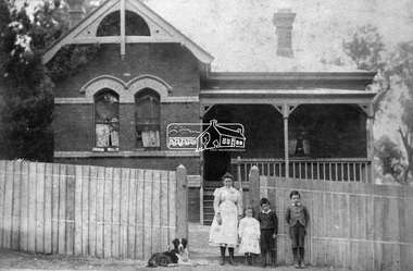
Negative - Photograph, Wall Bros, State School Residence, Dalton Street, Eltham, c.1902
Shows Mrs J. Brown, one of her four daughtrers and her two sons who died in World War One with their dog posing in front of fence of Headmaster's house, at Eltham State School, Dalton Street. Date circa 1902. The building still stands. Reproduced p66 of Pioneers & Painters Mrs Jane Elizabeth Brown (nee Staines) and three children of her large family who left the Headmaster's residence when John Brown (Headmaster 1889-1906) died (on the job) in 1906. John and Jane had ten children eight girls and two boys. Their two sons both died in the 1914-1918 War; George Stewart Brown (1885-1916) and John Leonard Brown (1887-1918). The young girl may be Elsie Maria Brown (1889-1917) which would date the photo around 1902. Wall Bros operated at St Kilda from around 1889 to 1903. John Brown died 23 Sept 1906 after a short severe illness at age 55 and is buried in Box Hill Cemetery (Evelyn Observer 28 Sep 1906 p2). The book "We did open a school in Little Eltham" incorrectly states his date of death as 16/12/1906. Title The Evelyn Observer. (1906, September 28). Evelyn Observer and Bourke East Record (Vic. : 1902 - 1917), p. 2 (MORNING.) Url http://nla.gov.au/nla.news-article61129880 Description It is with sincere regret we record the death of Mr. John Brown, State school teacher, Eltham, which sad event took place at his residence, "Pine Brae," on Sunday night last, 23rd inst. after a severe illness of some few weeks' duration. The deceased gentleman was highly respected, and always took a lively and active interest in promoting the progress and prosperity of the district, and his loss will be much felt, He was only 55 years of age, and leaves a wife and large family to mourn their loss, and much sympathy is felt for them. The remains of the deceased were interred in the Box Hill cemetery on Wednesday afternoon last. This photo forms part of a collection of photographs gathered by the Shire of Eltham for their centenary project book,"Pioneers and Painters: 100 years of the Shire of Eltham" by Alan Marshall (1971). The collection of over 500 images is held in partnership between Eltham District Historical Society and Yarra Plenty Regional Library (Eltham Library) and is now formally known as 'The Shire of Eltham Pioneers Photograph Collection.' It is significant in being the first community sourced collection representing the places and people of the Shire's first one hundred years.Digital image 4 x 5 inch B&W Neg Sepia photo B&W printSepia photo reverse: Miss Tonkinson Used Pioneers and Painters p66 Could be Miss Brown and part of her family who left the Headmaster's residence when John Brown (Headmaster 1889-1906) died (on the job) in 1906. Then 2 sons both died in the 1914-1918 War Between 1888 and prior to 1906. Also Wall Bros. St Kilda stamp B&W print: 66 and 9 7/16" x 5 5/8" deep (for publication on p66 of Pioneers & Painters)sepp, shire of eltham pioneers photograph collection, state school residence, eltham state school, state school no. 209, dalton street, eltham primary school, teacher residence, eltham, headmaster, houses, main road, pioneers and painters, school, school residence, schools, george stewart brown (1885-1916), elsie maria brown (1889-1917), john leonard brown (1887-1918), jane elizabeth brown (nee staines) -
 Beechworth RSL Sub-Branch
Uniform - Jacket, Dress Uniform size 38 short, Jacket Service Dress Army, C. 1968
Standard dress uniform jacket for soldiers.Khaki coloured single breasted jacket fastened with four centre plastic buttons and a belt. Belt attached to jacket on back via two leather loops buttoned around a fabric loop. Jacket carries two breast pockets on exterior with flap, each fastened with single plastic button and two metal press studs. Two hip pockets with flaps, unfastened. Interior is lined with synthetic fabric; one interior chest pocket on the left hand side underneath which is a manufacturers label (transcribed below). Small square paper tag sewn into left jacket interior (transcribed below).Interior label reads "E.W. P/LTD./SOUTH AUSTRALIA/1968/[broad arrow symbol]/SIZE 36 SHORT/CLASS 8406/66-019-8479/ARMY No./NAME/DRY CLEAN ONLY./REPRESS USING IRON AND DAMP CLOTH OR MEDIUM TO HOT STEAM IRON./CREASE UPPER HALF OF LAPELS ONLY." Written on the label is handwritten text "J.V." And "12/0L/0/67." Stamped in purple ink "BATCH No./385." Paper tag reads "62000/LOT 12 36S/GLOBE6/67."military, uniform, vietnam war, 1960s, dress uniform, beechworth, returned services league -
 Bendigo Military Museum
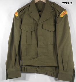
Uniform - JACKET, TROUSERS, BATTLE DRESS, ARMY, 1978-80
Name on label - uniform issued to; 1. "GITTINS" 331103" 2. "J.J. SMITH"1. Jacket - khaki colour wool serge fabric. battle dress style, belted at waist with metal buckle. Dark green plastic buttons. Collar, shoulder epaulettes, two front pockets with concealed button down flap and sleeve cuffs. Shoulder sleeve insignia, red cotton embroidered lettering on yellow colour fabric - "FIRST ARMOURED REGIMENT". Green colour cotton fabric lining to waistband. White cotton manufacturers label inside left pocket. 2. Trousers - Khaki colour wool serge fabric. Battle dress style with fob pocket, two side pockets, one back pocket with button down flap. Green colour polyester fabric lining to pockets, cotton fabric lining to waistband. Metal zipper fly,Manufacturers information on labels - black ink print. 1. "A.G.C.F."/VIC. 1980/^ /8405.66.025.6406/SIZE OF CHEST/ SIZE 89/91R/ AWM 87/ BATCH 15/ DRY CLEAN ONLY/ CREASE UPPER/ HALF OF LAPELS ONLY/ NO./ NAME" Handwritten - black ink pen "331103/GITTINS". 2. A.G.C.F./VIC 1978/^/8405-66--025-6187/ AWM 1969/ BATCH 18/ SIZE WAIST 76s/ DRY CLEAN ONLY/ CREASES SET/ BY SIRO SET/ MENDING PATCH ATTACHED" Handwritten = black ink pen "J.J. SMITH".uniform, army, battle dress, gittins, smith -
 Lara RSL Sub Branch
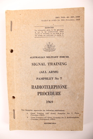
Pamphlet, Signal training pamphlet
A brown cardboard pamphlet. Used by all arms, the pamphlet provides the radiotelephone procedures. DSN 7610-66-029-1400 Australian Military Forces Signal Training (All arms) pamphlet no 7: radiotelephone procedure 1969 Restricted The information given in this document is not to be communicated, either directly or indirectly, to the Press or to any person not authorised. Australian Military Forces Signal training All arms Pamphlet no 7 Radiotelephone procedure 1969 This pamphlet supersedes the following publications: A. Signal training (all arms), pamphlet no 7, voice procedure 1963 B. Signal training (all arms), pamphlet no 7, radiotelephone procedure (provisional) (1968) pamphlet, instructions, training, signal training, radiotelephone, 1969, restricted, australian military forces -
 Warrnambool RSL Sub Branch
Trousers, Australian Defence Apparel, 2015
These trousers are part of a Disruptive Pattern Combat Uniform issued by the Australian Airforce to Bernard Farley during service. This uniform type was used in base and field activities and was replaced in 2014 by the General Purpose Uniform as the uniform worn during general base duties and in non-warlike environments.This item has social significance, as an item of uniform worn by Warrnambool RSL community member and Secretary (2019), Bernard Farley during service with the Australian Airforce. The item is a representative example of previously standard issue Airforce uniform and is in excellent condition. As a set, the uniform has aesthetic significance in it’s design, incorporating the Disruptive Pattern style of camouflage which has its roots in the 1980s and continues to be adapted into uniform design by the Defence Force.Disruptive Pattern trousers in five colours of green and brown. Long pants with elasticised drawstring fastener at ankle and velcro adjustment fasteners at the waist. Pants take a straight leg style and bears several pockets: two thigh level pockets with zippered horizontal opening, two open hip pockets on the front, one open pocket on the reverse right hand side with blue plastic button fastener. Five large belt loops encircle the waist and there is a zippered fly, secured at the top with a blue plastic button.Label on interior front right of trousers reads: “A13/ADA/VICTORIA 2008/(broad arrow)/SPECIFICATION ARMY (AUST)6542/NSN: 8415 66 152 1059/SIZE: 95 S/NAME/SERVICE NO/75% COTTON 25% POLYESTER/WARM MACHINE WASH 40*C/RINSE WELL, WARM IRON/DO NOT IRON OVER HOOK AND PILE/DO NOT BLEACH/DO NOT STARCH/MAY BE TUMBLE DRY 40*C/MADE IN AUSTRALIA” The name “FARLEY” is also handwritten on the back interior waist band of the trousers. camouflage, general purpose uniform, airforce, uniform, australian defence force -
 Eltham District Historical Society Inc
Photograph, Liz Pidgeon, Heritage Excursion; Maroondah Aqueduct, 3 September 2016, 3 September 2016
Newsletter No., 229, August 2016 Heritage Excursion - Maroondah Aqueduct Walk - Saturday 3rd September The Maroondah Aqueduct was once a major link in Melbourne’s water supply system. It was built between 1886 and 1891 to transfer water from the Watts River near Healesville to the Preston Reservoir. It was 66 km in length, made up of 41 km of open channel, 10 km of tunnel through hills and 15 km of pipeline across stream valleys known as inverted siphons. The section of the aqueduct through the Eltham area has been abandoned since the 1980s but the open channel has largely been retained. A recreational path follows the aqueduct reserve. For our excursion on 3rd September we intend to walk along the section of the aqueduct adjacent to Allendale Road. This is a section not visited on previous excursions and includes the transition from open channel to the inverted siphon across the Diamond Creek valley. Apart from the aqueduct itself the main feature of the walk is the extensive views across Eltham North and Diamond Creek. Along the way we will talk about the history of the aqueduct and the area. This easy walk is about 3 km return and will take 2 to 2.5 hours. It will start at 2pm at the junction of Allendale Road with Godber Road and Zig Zag Road North, officially Diamond Creek, but on the northern boundary of Eltham. (Melway ref.12 B10). Born Digitalmaroondah aqueduct, eltham north, activities, eltham district historical society, heritage excursion, acqueduct trail, sign -
 Eltham District Historical Society Inc
Photograph, Liz Pidgeon, Heritage Excursion; Maroondah Aqueduct, 3 September 2016, 3 September 2016
Newsletter No., 229, August 2016 Heritage Excursion - Maroondah Aqueduct Walk - Saturday 3rd September The Maroondah Aqueduct was once a major link in Melbourne’s water supply system. It was built between 1886 and 1891 to transfer water from the Watts River near Healesville to the Preston Reservoir. It was 66 km in length, made up of 41 km of open channel, 10 km of tunnel through hills and 15 km of pipeline across stream valleys known as inverted siphons. The section of the aqueduct through the Eltham area has been abandoned since the 1980s but the open channel has largely been retained. A recreational path follows the aqueduct reserve. For our excursion on 3rd September we intend to walk along the section of the aqueduct adjacent to Allendale Road. This is a section not visited on previous excursions and includes the transition from open channel to the inverted siphon across the Diamond Creek valley. Apart from the aqueduct itself the main feature of the walk is the extensive views across Eltham North and Diamond Creek. Along the way we will talk about the history of the aqueduct and the area. This easy walk is about 3 km return and will take 2 to 2.5 hours. It will start at 2pm at the junction of Allendale Road with Godber Road and Zig Zag Road North, officially Diamond Creek, but on the northern boundary of Eltham. (Melway ref.12 B10). Born Digitalmaroondah aqueduct, eltham north, activities, eltham district historical society, heritage excursion, acqueduct trail, diamond creek -
 Eltham District Historical Society Inc
Photograph, Liz Pidgeon, Heritage Excursion; Maroondah Aqueduct, 3 September 2016, 3 September 2016
Newsletter No., 229, August 2016 Heritage Excursion - Maroondah Aqueduct Walk - Saturday 3rd September The Maroondah Aqueduct was once a major link in Melbourne’s water supply system. It was built between 1886 and 1891 to transfer water from the Watts River near Healesville to the Preston Reservoir. It was 66 km in length, made up of 41 km of open channel, 10 km of tunnel through hills and 15 km of pipeline across stream valleys known as inverted siphons. The section of the aqueduct through the Eltham area has been abandoned since the 1980s but the open channel has largely been retained. A recreational path follows the aqueduct reserve. For our excursion on 3rd September we intend to walk along the section of the aqueduct adjacent to Allendale Road. This is a section not visited on previous excursions and includes the transition from open channel to the inverted siphon across the Diamond Creek valley. Apart from the aqueduct itself the main feature of the walk is the extensive views across Eltham North and Diamond Creek. Along the way we will talk about the history of the aqueduct and the area. This easy walk is about 3 km return and will take 2 to 2.5 hours. It will start at 2pm at the junction of Allendale Road with Godber Road and Zig Zag Road North, officially Diamond Creek, but on the northern boundary of Eltham. (Melway ref.12 B10). Born Digitalmaroondah aqueduct, eltham north, activities, eltham district historical society, heritage excursion, acqueduct trail, sign -
 Eltham District Historical Society Inc
Photograph, Liz Pidgeon, Heritage Excursion; Maroondah Aqueduct, 3 September 2016, 3 September 2016
Newsletter No., 229, August 2016 Heritage Excursion - Maroondah Aqueduct Walk - Saturday 3rd September The Maroondah Aqueduct was once a major link in Melbourne’s water supply system. It was built between 1886 and 1891 to transfer water from the Watts River near Healesville to the Preston Reservoir. It was 66 km in length, made up of 41 km of open channel, 10 km of tunnel through hills and 15 km of pipeline across stream valleys known as inverted siphons. The section of the aqueduct through the Eltham area has been abandoned since the 1980s but the open channel has largely been retained. A recreational path follows the aqueduct reserve. For our excursion on 3rd September we intend to walk along the section of the aqueduct adjacent to Allendale Road. This is a section not visited on previous excursions and includes the transition from open channel to the inverted siphon across the Diamond Creek valley. Apart from the aqueduct itself the main feature of the walk is the extensive views across Eltham North and Diamond Creek. Along the way we will talk about the history of the aqueduct and the area. This easy walk is about 3 km return and will take 2 to 2.5 hours. It will start at 2pm at the junction of Allendale Road with Godber Road and Zig Zag Road North, officially Diamond Creek, but on the northern boundary of Eltham. (Melway ref.12 B10). Born Digitalmaroondah aqueduct, eltham north, activities, eltham district historical society, heritage excursion, acqueduct trail -
 Eltham District Historical Society Inc
Photograph, Liz Pidgeon, Heritage Excursion; Maroondah Aqueduct, 3 September 2016, 3 September 2016
Intersection with local Street signs Newsletter No., 229, August 2016 Heritage Excursion - Maroondah Aqueduct Walk - Saturday 3rd September The Maroondah Aqueduct was once a major link in Melbourne’s water supply system. It was built between 1886 and 1891 to transfer water from the Watts River near Healesville to the Preston Reservoir. It was 66 km in length, made up of 41 km of open channel, 10 km of tunnel through hills and 15 km of pipeline across stream valleys known as inverted siphons. The section of the aqueduct through the Eltham area has been abandoned since the 1980s but the open channel has largely been retained. A recreational path follows the aqueduct reserve. For our excursion on 3rd September we intend to walk along the section of the aqueduct adjacent to Allendale Road. This is a section not visited on previous excursions and includes the transition from open channel to the inverted siphon across the Diamond Creek valley. Apart from the aqueduct itself the main feature of the walk is the extensive views across Eltham North and Diamond Creek. Along the way we will talk about the history of the aqueduct and the area. This easy walk is about 3 km return and will take 2 to 2.5 hours. It will start at 2pm at the junction of Allendale Road with Godber Road and Zig Zag Road North, officially Diamond Creek, but on the northern boundary of Eltham. (Melway ref.12 B10). Born Digitalmaroondah aqueduct, eltham north, activities, eltham district historical society, heritage excursion, street signs, acqueduct trail, allendale rd, godber rd, zig zag road, intersection -
 Eltham District Historical Society Inc
Photograph, Liz Pidgeon, Heritage Excursion; Maroondah Aqueduct, 3 September 2016, 3 September 2016
Newsletter No., 229, August 2016 Heritage Excursion - Maroondah Aqueduct Walk - Saturday 3rd September The Maroondah Aqueduct was once a major link in Melbourne’s water supply system. It was built between 1886 and 1891 to transfer water from the Watts River near Healesville to the Preston Reservoir. It was 66 km in length, made up of 41 km of open channel, 10 km of tunnel through hills and 15 km of pipeline across stream valleys known as inverted siphons. The section of the aqueduct through the Eltham area has been abandoned since the 1980s but the open channel has largely been retained. A recreational path follows the aqueduct reserve. For our excursion on 3rd September we intend to walk along the section of the aqueduct adjacent to Allendale Road. This is a section not visited on previous excursions and includes the transition from open channel to the inverted siphon across the Diamond Creek valley. Apart from the aqueduct itself the main feature of the walk is the extensive views across Eltham North and Diamond Creek. Along the way we will talk about the history of the aqueduct and the area. This easy walk is about 3 km return and will take 2 to 2.5 hours. It will start at 2pm at the junction of Allendale Road with Godber Road and Zig Zag Road North, officially Diamond Creek, but on the northern boundary of Eltham. (Melway ref.12 B10). Born Digitalmaroondah aqueduct, eltham north, activities, eltham district historical society, heritage excursion, acqueduct trail -
 Eltham District Historical Society Inc
Photograph, Liz Pidgeon, Heritage Excursion; Maroondah Aqueduct, 3 September 2016, 3 September 2016
Property related to Yarra Valley Water, Diamond Creek Newsletter No., 229, August 2016 Heritage Excursion - Maroondah Aqueduct Walk - Saturday 3rd September The Maroondah Aqueduct was once a major link in Melbourne’s water supply system. It was built between 1886 and 1891 to transfer water from the Watts River near Healesville to the Preston Reservoir. It was 66 km in length, made up of 41 km of open channel, 10 km of tunnel through hills and 15 km of pipeline across stream valleys known as inverted siphons. The section of the aqueduct through the Eltham area has been abandoned since the 1980s but the open channel has largely been retained. A recreational path follows the aqueduct reserve. For our excursion on 3rd September we intend to walk along the section of the aqueduct adjacent to Allendale Road. This is a section not visited on previous excursions and includes the transition from open channel to the inverted siphon across the Diamond Creek valley. Apart from the aqueduct itself the main feature of the walk is the extensive views across Eltham North and Diamond Creek. Along the way we will talk about the history of the aqueduct and the area. This easy walk is about 3 km return and will take 2 to 2.5 hours. It will start at 2pm at the junction of Allendale Road with Godber Road and Zig Zag Road North, officially Diamond Creek, but on the northern boundary of Eltham. (Melway ref.12 B10). Born Digitalmaroondah aqueduct, eltham north, activities, eltham district historical society, heritage excursion, yarra valley water, diamond creek -
 Eltham District Historical Society Inc
Photograph, Liz Pidgeon, Heritage Excursion; Maroondah Aqueduct, 3 September 2016, 3 September 2016
Sign for Yarra Valley Water at Diamond Creek property Newsletter No., 229, August 2016 Heritage Excursion - Maroondah Aqueduct Walk - Saturday 3rd September The Maroondah Aqueduct was once a major link in Melbourne’s water supply system. It was built between 1886 and 1891 to transfer water from the Watts River near Healesville to the Preston Reservoir. It was 66 km in length, made up of 41 km of open channel, 10 km of tunnel through hills and 15 km of pipeline across stream valleys known as inverted siphons. The section of the aqueduct through the Eltham area has been abandoned since the 1980s but the open channel has largely been retained. A recreational path follows the aqueduct reserve. For our excursion on 3rd September we intend to walk along the section of the aqueduct adjacent to Allendale Road. This is a section not visited on previous excursions and includes the transition from open channel to the inverted siphon across the Diamond Creek valley. Apart from the aqueduct itself the main feature of the walk is the extensive views across Eltham North and Diamond Creek. Along the way we will talk about the history of the aqueduct and the area. This easy walk is about 3 km return and will take 2 to 2.5 hours. It will start at 2pm at the junction of Allendale Road with Godber Road and Zig Zag Road North, officially Diamond Creek, but on the northern boundary of Eltham. (Melway ref.12 B10). Born Digitalmaroondah aqueduct, eltham north, activities, eltham district historical society, heritage excursion, diamond creek, yarra valley water, sign -
 Eltham District Historical Society Inc
Photograph, Liz Pidgeon, Heritage Excursion; Maroondah Aqueduct, 3 September 2016, 3 September 2016
Newsletter No., 229, August 2016 Heritage Excursion - Maroondah Aqueduct Walk - Saturday 3rd September The Maroondah Aqueduct was once a major link in Melbourne’s water supply system. It was built between 1886 and 1891 to transfer water from the Watts River near Healesville to the Preston Reservoir. It was 66 km in length, made up of 41 km of open channel, 10 km of tunnel through hills and 15 km of pipeline across stream valleys known as inverted siphons. The section of the aqueduct through the Eltham area has been abandoned since the 1980s but the open channel has largely been retained. A recreational path follows the aqueduct reserve. For our excursion on 3rd September we intend to walk along the section of the aqueduct adjacent to Allendale Road. This is a section not visited on previous excursions and includes the transition from open channel to the inverted siphon across the Diamond Creek valley. Apart from the aqueduct itself the main feature of the walk is the extensive views across Eltham North and Diamond Creek. Along the way we will talk about the history of the aqueduct and the area. This easy walk is about 3 km return and will take 2 to 2.5 hours. It will start at 2pm at the junction of Allendale Road with Godber Road and Zig Zag Road North, officially Diamond Creek, but on the northern boundary of Eltham. (Melway ref.12 B10). Born Digitalmaroondah aqueduct, eltham north, activities, eltham district historical society, heritage excursion, acqueduct trail -
 Eltham District Historical Society Inc
Photograph, Liz Pidgeon, Heritage Excursion; Maroondah Aqueduct, 3 September 2016, 3 September 2016
View of Diamond Creek Newsletter No., 229, August 2016 Heritage Excursion - Maroondah Aqueduct Walk - Saturday 3rd September The Maroondah Aqueduct was once a major link in Melbourne’s water supply system. It was built between 1886 and 1891 to transfer water from the Watts River near Healesville to the Preston Reservoir. It was 66 km in length, made up of 41 km of open channel, 10 km of tunnel through hills and 15 km of pipeline across stream valleys known as inverted siphons. The section of the aqueduct through the Eltham area has been abandoned since the 1980s but the open channel has largely been retained. A recreational path follows the aqueduct reserve. For our excursion on 3rd September we intend to walk along the section of the aqueduct adjacent to Allendale Road. This is a section not visited on previous excursions and includes the transition from open channel to the inverted siphon across the Diamond Creek valley. Apart from the aqueduct itself the main feature of the walk is the extensive views across Eltham North and Diamond Creek. Along the way we will talk about the history of the aqueduct and the area. This easy walk is about 3 km return and will take 2 to 2.5 hours. It will start at 2pm at the junction of Allendale Road with Godber Road and Zig Zag Road North, officially Diamond Creek, but on the northern boundary of Eltham. (Melway ref.12 B10). Born Digitalmaroondah aqueduct, eltham north, activities, eltham district historical society, heritage excursion, diamond creek, acqueduct trail -
 Eltham District Historical Society Inc
Photograph, Liz Pidgeon, Heritage Excursion; Maroondah Aqueduct, 3 September 2016, 3 September 2016
Russell Yeomann provides historical information on the heritage excursion From the Newsletter No., 229, August 2016 Heritage Excursion - Maroondah Aqueduct Walk - Saturday 3rd September The Maroondah Aqueduct was once a major link in Melbourne’s water supply system. It was built between 1886 and 1891 to transfer water from the Watts River near Healesville to the Preston Reservoir. It was 66 km in length, made up of 41 km of open channel, 10 km of tunnel through hills and 15 km of pipeline across stream valleys known as inverted siphons. The section of the aqueduct through the Eltham area has been abandoned since the 1980s but the open channel has largely been retained. A recreational path follows the aqueduct reserve. For our excursion on 3rd September we intend to walk along the section of the aqueduct adjacent to Allendale Road. This is a section not visited on previous excursions and includes the transition from open channel to the inverted siphon across the Diamond Creek valley. Apart from the aqueduct itself the main feature of the walk is the extensive views across Eltham North and Diamond Creek. Along the way we will talk about the history of the aqueduct and the area. This easy walk is about 3 km return and will take 2 to 2.5 hours. It will start at 2pm at the junction of Allendale Road with Godber Road and Zig Zag Road North, officially Diamond Creek, but on the northern boundary of Eltham. (Melway ref.12 B10). Born Digitalmaroondah aqueduct, eltham north, activities, eltham district historical society, heritage excursion, russell yeoman, aqueduct trail -
 Eltham District Historical Society Inc
Photograph, Liz Pidgeon, Heritage Excursion; Maroondah Aqueduct, 3 September 2016, 3 September 2016
Newsletter No., 229, August 2016 Heritage Excursion - Maroondah Aqueduct Walk - Saturday 3rd September The Maroondah Aqueduct was once a major link in Melbourne’s water supply system. It was built between 1886 and 1891 to transfer water from the Watts River near Healesville to the Preston Reservoir. It was 66 km in length, made up of 41 km of open channel, 10 km of tunnel through hills and 15 km of pipeline across stream valleys known as inverted siphons. The section of the aqueduct through the Eltham area has been abandoned since the 1980s but the open channel has largely been retained. A recreational path follows the aqueduct reserve. For our excursion on 3rd September we intend to walk along the section of the aqueduct adjacent to Allendale Road. This is a section not visited on previous excursions and includes the transition from open channel to the inverted siphon across the Diamond Creek valley. Apart from the aqueduct itself the main feature of the walk is the extensive views across Eltham North and Diamond Creek. Along the way we will talk about the history of the aqueduct and the area. This easy walk is about 3 km return and will take 2 to 2.5 hours. It will start at 2pm at the junction of Allendale Road with Godber Road and Zig Zag Road North, officially Diamond Creek, but on the northern boundary of Eltham. (Melway ref.12 B10). Born Digitalmaroondah aqueduct, eltham north, activities, eltham district historical society, heritage excursion, water-pipes, pipes, cattle yard, aqueduct trail -
 Eltham District Historical Society Inc
Photograph, Liz Pidgeon, Heritage Excursion; Maroondah Aqueduct, 3 September 2016, 3 September 2016
Newsletter No., 229, August 2016 Heritage Excursion - Maroondah Aqueduct Walk - Saturday 3rd September The Maroondah Aqueduct was once a major link in Melbourne’s water supply system. It was built between 1886 and 1891 to transfer water from the Watts River near Healesville to the Preston Reservoir. It was 66 km in length, made up of 41 km of open channel, 10 km of tunnel through hills and 15 km of pipeline across stream valleys known as inverted siphons. The section of the aqueduct through the Eltham area has been abandoned since the 1980s but the open channel has largely been retained. A recreational path follows the aqueduct reserve. For our excursion on 3rd September we intend to walk along the section of the aqueduct adjacent to Allendale Road. This is a section not visited on previous excursions and includes the transition from open channel to the inverted siphon across the Diamond Creek valley. Apart from the aqueduct itself the main feature of the walk is the extensive views across Eltham North and Diamond Creek. Along the way we will talk about the history of the aqueduct and the area. This easy walk is about 3 km return and will take 2 to 2.5 hours. It will start at 2pm at the junction of Allendale Road with Godber Road and Zig Zag Road North, officially Diamond Creek, but on the northern boundary of Eltham. (Melway ref.12 B10). Born Digitalmaroondah aqueduct, eltham north, activities, eltham district historical society, heritage excursion, aqueduct trail, cattle yard -
 Eltham District Historical Society Inc
Photograph, Liz Pidgeon, Heritage Excursion; Maroondah Aqueduct, 3 September 2016, 3 September 2016
Newsletter No., 229, August 2016 Heritage Excursion - Maroondah Aqueduct Walk - Saturday 3rd September The Maroondah Aqueduct was once a major link in Melbourne’s water supply system. It was built between 1886 and 1891 to transfer water from the Watts River near Healesville to the Preston Reservoir. It was 66 km in length, made up of 41 km of open channel, 10 km of tunnel through hills and 15 km of pipeline across stream valleys known as inverted siphons. The section of the aqueduct through the Eltham area has been abandoned since the 1980s but the open channel has largely been retained. A recreational path follows the aqueduct reserve. For our excursion on 3rd September we intend to walk along the section of the aqueduct adjacent to Allendale Road. This is a section not visited on previous excursions and includes the transition from open channel to the inverted siphon across the Diamond Creek valley. Apart from the aqueduct itself the main feature of the walk is the extensive views across Eltham North and Diamond Creek. Along the way we will talk about the history of the aqueduct and the area. This easy walk is about 3 km return and will take 2 to 2.5 hours. It will start at 2pm at the junction of Allendale Road with Godber Road and Zig Zag Road North, officially Diamond Creek, but on the northern boundary of Eltham. (Melway ref.12 B10). Born Digitalmaroondah aqueduct, eltham north, activities, eltham district historical society, heritage excursion, aqueduct trail, water-pipe, pipe -
 Eltham District Historical Society Inc
Photograph, Liz Pidgeon, Heritage Excursion; Maroondah Aqueduct, 3 September 2016, 3 September 2016
Newsletter No., 229, August 2016 Heritage Excursion - Maroondah Aqueduct Walk - Saturday 3rd September The Maroondah Aqueduct was once a major link in Melbourne’s water supply system. It was built between 1886 and 1891 to transfer water from the Watts River near Healesville to the Preston Reservoir. It was 66 km in length, made up of 41 km of open channel, 10 km of tunnel through hills and 15 km of pipeline across stream valleys known as inverted siphons. The section of the aqueduct through the Eltham area has been abandoned since the 1980s but the open channel has largely been retained. A recreational path follows the aqueduct reserve. For our excursion on 3rd September we intend to walk along the section of the aqueduct adjacent to Allendale Road. This is a section not visited on previous excursions and includes the transition from open channel to the inverted siphon across the Diamond Creek valley. Apart from the aqueduct itself the main feature of the walk is the extensive views across Eltham North and Diamond Creek. Along the way we will talk about the history of the aqueduct and the area. This easy walk is about 3 km return and will take 2 to 2.5 hours. It will start at 2pm at the junction of Allendale Road with Godber Road and Zig Zag Road North, officially Diamond Creek, but on the northern boundary of Eltham. (Melway ref.12 B10). Born Digitalmaroondah aqueduct, eltham north, activities, eltham district historical society, heritage excursion, aqueduct trail, cattle yards -
 Eltham District Historical Society Inc
Photograph, Liz Pidgeon, Heritage Excursion; Maroondah Aqueduct, 3 September 2016, 3 September 2016
Heritage Excursion - Maroondah Aqueduct Walk - Saturday 3rd September The Maroondah Aqueduct was once a major link in Melbourne’s water supply system. It was built between 1886 and 1891 to transfer water from the Watts River near Healesville to the Preston Reservoir. It was 66 km in length, made up of 41 km of open channel, 10 km of tunnel through hills and 15 km of pipeline across stream valleys known as inverted siphons. The section of the aqueduct through the Eltham area has been abandoned since the 1980s but the open channel has largely been retained. A recreational path follows the aqueduct reserve. For our excursion on 3rd September we intend to walk along the section of the aqueduct adjacent to Allendale Road. This is a section not visited on previous excursions and includes the transition from open channel to the inverted siphon across the Diamond Creek valley. Apart from the aqueduct itself the main feature of the walk is the extensive views across Eltham North and Diamond Creek. Along the way we will talk about the history of the aqueduct and the area. This easy walk is about 3 km return and will take 2 to 2.5 hours. It will start at 2pm at the junction of Allendale Road with Godber Road and Zig Zag Road North, officially Diamond Creek, but on the northern boundary of Eltham. (Melway ref.12 B10). From Newsletter No., 229, August 2016 Born Digitalmaroondah aqueduct, eltham north, activities, eltham district historical society, heritage excursion, aqueduct trail, water-pipe, pipe