Showing 14572 items matching "bridge-playing"
-
 The Beechworth Burke Museum Research Collection
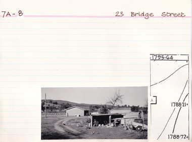
Card (Series) - Index Card, George Tibbits, 23 Bridge Street, Beechworth, 1976
George Tibbits, University of Melbourne. Faculty of Architecture, Building and Town & Regional PlanningIndex system that support the research for Beechworth : historical reconstruction / [by] George Tibbits ... [et al]Arranged by street names of BeechworthEach index card includes: street name and number of property, image of property, allotment and section number, property owners and dates of ownership, description of the property according to rate records, property floor plan with dimensions.beechworth, george tibbitsbeechworth, george tibbits -
 The Beechworth Burke Museum Research Collection
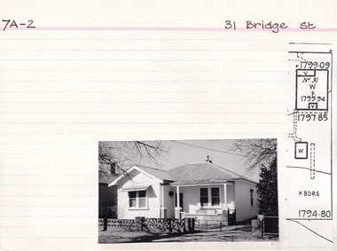
Card (Series) - Index Card, George Tibbits, 31 Bridge Street, Beechworth, 1976
George Tibbits, University of Melbourne. Faculty of Architecture, Building and Town & Regional PlanningIndex system that support the research for Beechworth : historical reconstruction / [by] George Tibbits ... [et al]Arranged by street names of BeechworthEach index card includes: street name and number of property, image of property, allotment and section number, property owners and dates of ownership, description of the property according to rate records, property floor plan with dimensions.beechworth, george tibbitsbeechworth, george tibbits -
 The Beechworth Burke Museum Research Collection
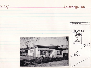
Card (Series) - Index Card, George Tibbits, 37 Bridge Street, Beechworth, 1976
George Tibbits, University of Melbourne. Faculty of Architecture, Building and Town & Regional PlanningIndex system that support the research for Beechworth : historical reconstruction / [by] George Tibbits ... [et al]Arranged by street names of BeechworthEach index card includes: street name and number of property, image of property, allotment and section number, property owners and dates of ownership, description of the property according to rate records, property floor plan with dimensions.beechworth, george tibbitsbeechworth, george tibbits -
 The Beechworth Burke Museum Research Collection
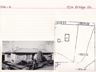
Card (Series) - Index Card, George Tibbits, 37A Bridge Street, Beechworth, 1976
George Tibbits, University of Melbourne. Faculty of Architecture, Building and Town & Regional PlanningIndex system that support the research for Beechworth : historical reconstruction / [by] George Tibbits ... [et al]Arranged by street names of BeechworthEach index card includes: street name and number of property, image of property, allotment and section number, property owners and dates of ownership, description of the property according to rate records, property floor plan with dimensions.beechworth, george tibbitsbeechworth, george tibbits -
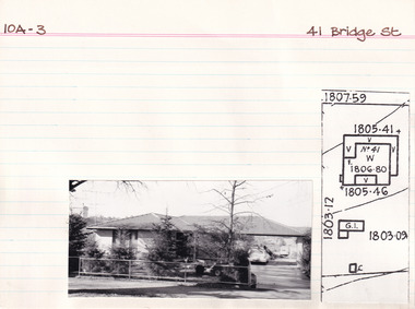 The Beechworth Burke Museum Research Collection
Card (Series) - Index Card, George Tibbits, 41 Bridge Street, Beechworth, 1976
George Tibbits, University of Melbourne. Faculty of Architecture, Building and Town & Regional PlanningIndex system that support the research for Beechworth : historical reconstruction / [by] George Tibbits ... [et al]Arranged by street names of BeechworthEach index card includes: street name and number of property, image of property, allotment and section number, property owners and dates of ownership, description of the property according to rate records, property floor plan with dimensions.beechworth, george tibbitsbeechworth, george tibbits -
 The Beechworth Burke Museum Research Collection
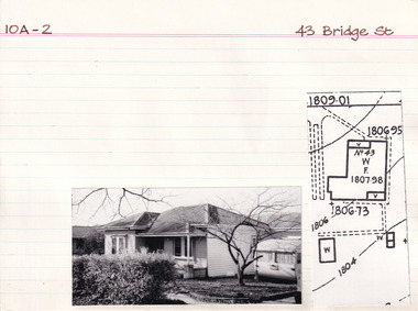
Card - Index Card, George Tibbits, 43 Bridge Street, Beechworth, 1976
Property - 43 Bridge Street, Beechworth - Section 10A, Town Allotment 2 - 100' x 440' Ownership details and history - 6 Jan 1871 - J. Reeve Architectural Index Card - Brian Pump and Tony Dugan - Photographers beechworth, george tibbits -
 Ringwood and District Historical Society
Envelope, Packet: Ringwood Area Hotels - Coach and Horses, Empress India, Burnt Bridge. Also Antimony Mine Hotel Proclaimed 1878
Hotels list; Coach and Horses Hotel; Club Hotel Sept-1887 Wiggin sold to Lindsey; Empress India Hotel; Antimony Mine Hotel, East Ringwood, Cnr Main & Pratt St proclaimed 21-Jan-1878 owing to increase in mining population, 4 licences in locality; Burnt Bridge Hotel; "Duke of York" -
 Melbourne Tram Museum
Document - Research Notes, H. S. McComb, Details of Richmond line - Spencer St, Flinders St and Bridge Road, c1930
Notes, 9 pages, has been pinned together, giving details, opening dates, terminals, depot entries, sheave pits, curves, for the Richmond line - Spencer St, Flinders St and Bridge Road. Items 2064 to 2075 within box 72.3 in a brown folder marked "MT&O Co." red pencil on the front cover.trams, tramways, mto co, cable trams, drawings, reports, surveys, richmond, spencer st, flinders st, bridge rd -
 Melbourne Tram Museum
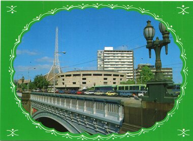
Postcard, Biscay Greetings, Princes Bridge from Batman Ave, mid to late 1980's
Colour postcard divided back - Biscay Greetings, series of featuring Princes Bridge from Batman Ave with the Arts Centre in the background. Image contained within a decorative oval. Back has space for name and address, stamp and a message and details of the postcard. Produced by Biscay Greetings, possibly mid to late 1980's. Card No. BG216trams, tramways, princes bridge -
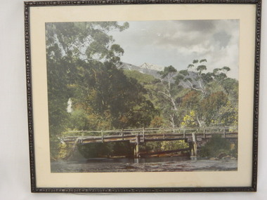
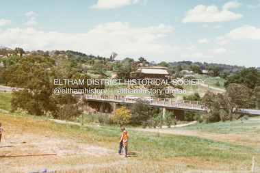 Eltham District Historical Society Inc
Photograph - Colour Print, Lewis Tulk, Bridge Street, Eltham District Scout Camp, Eltham Town Park, c.1982
View looking southeast from Eltham Town Park (present-day Al;istair Knox Park) across Bridge Street towards the new Eltham Community Centre. Donated by Lewis Tulk, former Scout Area Training Commisioner for Leaders.scouts victoria, scout leader training, lewis tulk collection, yarra batman area, alistair knox park, bridge street, eltham community centre, eltham district scout camp, eltham town park -
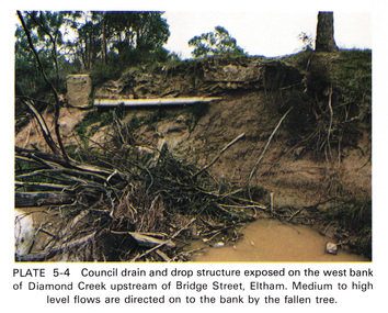 Eltham District Historical Society Inc
Work on paper (Sub-Item) - Photograph, Council drain and drop structure exposed on the west bank of Diamond Creek upstream of Bridge Street, Eltham
Colour photograph of a muddy creek (probably after a downpour) showing council drain and drop structure exposed on the west bank of Diamond Creek upstream of Bridge Street, Eltham. Mediun to high level water flows are directed on to the bank by the fallen tree.eltham, creek, diamond creek, bridge street, drainage, waterflow, vegetation -
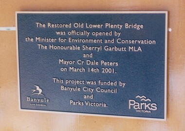 Greensborough Historical Society
Photograph - Digital Image, Anne Paul, Plaque: Opening of restored Old Lower Plenty Bridge 2001, 14/03/2001
This plaque commemorates the opening of the restored Old Lower Plenty Bridge, opened on 14/03/2001 by the Minister for Environment and Conservation Sherryl Garbutt MLA and Mayor of Banyule Cr Dale Peters. The project was jointly funded by Banyule Council and Parks Victoria.Digital copy of colour photograph of memorial plaquelower plenty, lower plenty bridge, sherryl garbutt, dale peters, banyule council, parks victoria -
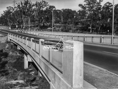 Eltham District Historical Society Inc
Photograph, Shire of Eltham, New bridge over the Plenty River, Lower Plenty, Nov. 1966
Newly constructed single span bridge on Main Road (now Lower Plenty Road) crossing the Plenty River at Lower Plenty. Site of Heidelberg Golf Club and Lower Plenty Hotel in the background. This was the boundary between the Shire of Eltham and the City of Heidelberg.This photo forms part of a collection of photographs gathered by the Shire of Eltham for their centenary project book ,"Pioneers and Painters: 100 years of the Shire of Eltham" by Alan Marshall (1971). The collection of over 500 images is held in partnership between Eltham District Historical Society and Yarra Plenty Regional Library (Eltham Library) and is now formally known as 'The Shire of Eltham Pioneers Photograph Collection.' It is significant in being the first community sourced collection representing the places and people of the Shire's first one hundred years.Digital imagesepp, shire of eltham pioneers photograph collection, lower plenty, bridge -
 Kiewa Valley Historical Society
Photo Framed - Broken Bridge, c1940's
The Tawonga Bridge over the East Kiewa River linked Mt Beauty with Tawonga. It was broken during Vera Hore's lifetime, 1909 - 2000. The bridge over the East Kiewa River enabled people to travel between Mt Beauty and Tawonga. Vera Hore (nee Ryder), the publican of the Tawonga Hotel, took this photo as she was a keen amateur photographer. Vera lived from Nov. 1909 to July 2000.Colored photo of 'Broken Bridge' over the East Kiewa River on Damm's Road with Mt Bogong, with snow, in the background of centre top. Framed with 2 cm wide cream cardboard surrounded by a metal decorated frame. The back has a flap for displaying the photo on a bench or table. On the back, a white sticker inscribed:- "Broken Bridge" / Old Timber Bridge / over East Kiewa River / on Damm's Rd." On the back top left corner hand written:- "Vera Hore"tawonga bridge; vera hore; east kiewa river; tawonga hotel -
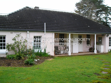
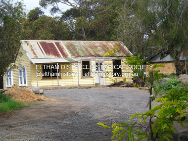
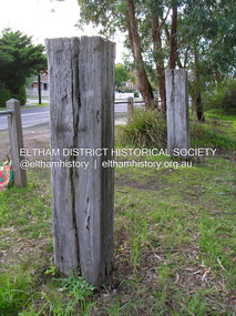 Eltham District Historical Society Inc
Photograph, Fay Bridge, Old posts, location TBC, 11 June 2019
fay bridge collection, 2019-06-11 -
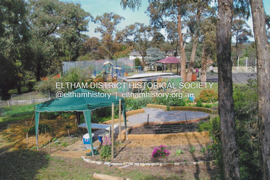
 Eltham District Historical Society Inc
Photograph, Fay Bridge, Rosehill Homestead, EDHS Heritage Excursion, 6 July 2019
July Excursion July 6, 2019 - Exploring Lower Plenty The predominant feature of this walk in the Bonds Road area, Lower Plenty is the large number of magnificent old River Red Gums that line the route. These trees are of the spreading woodland form of this species indicating that they must have been originally growing in a reasonably open setting. The walk also includes parts of the historic Cleveland Estate and the homestead “Rosehill” established by pioneer farmer Henry Stooke. This area was the site of the first recorded European settlement in what was to become the Shire of Eltham when the Willis brothers arrived in the late 1830s. From the southern part of Cleveland Avenue there are extensive views across and along the Yarra Valley. An article on the history of this area was contained in Newsletter edition 201, November 2011. The walk will start at the at the corner of Bonds and Stawell Roads, Lower Plenty - EDHS Newsletter No. 246 June 2019fay bridge collection, 2019-07-06, blackburn bricks, eltham district historical society, heritage excursion, rosehill homestead, lower plenty -
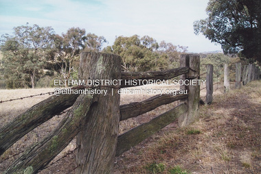
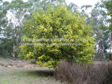 Eltham District Historical Society Inc
Photograph, Fay Bridge, Wattle tree, Sweeneys Flats, Eltham, 26 August 2019
fay bridge collection, sweeneys flats, wattle tree, 2019-08-26 -
 Eltham District Historical Society Inc
Photograph, Fay Bridge, United Service Station, Main Road, Eltham, 26 August 2019
fay bridge collection, 2019-08-26, cockatoos, diamond street, eltham, luck street, main road, united service station -
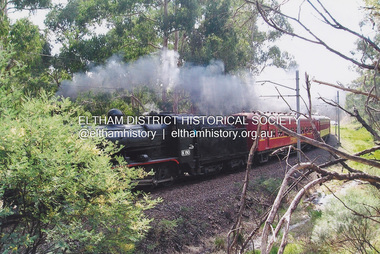 Eltham District Historical Society Inc
Photograph, Fay Bridge, United Service Station, Main Road, Eltham, 26 August 2019
fay bridge collection, 2019-08-26, hurstbridge wattle festival, k-153, k-class steam locomotive (vr newport workshops), steam locomotive, steamrail victoria -
 Eltham District Historical Society Inc
Photograph, Fay Bridge, EDHS Heritage Excursion, Culla Hill, Sweeneys Lane, Eltham, 7 September 2019
September Excursion - Culla Hill Walk Pioneer Eltham farmer Thomas Sweeney (1803 - 1867) named his house, “Culla Hill” after the area in Ireland that he came from. His house, now called “Sweeneys”, remains on a ridge line overlooking the Yarra River. It is recorded that Thomas Sweeney did well out of carting potatoes and other supplies to the various gold fields such as Bendigo, McIvor (Heathcote), Mount Alexander and Beechworth. Culla Hill is now the name of the road providing access to subdivided lots of the former Sweeney property. The Culla Hill walk will start at the corner of Kent Hughes and Lavender Park Roads, Eltham (Melway ref. 22 A9) at 2.00pm on Saturday 7th September. - EDHS Newsletter No. 247 August 20192019-09-07, activities, culla hill, eltham, eltham district historical society, fay bridge collection, heritage excursion, sweeneys lane -
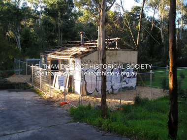 Eltham District Historical Society Inc
Photograph, Fay Bridge, Warrandyte cool store, 9 September 2019
Remains of the old Warrandyte Dairy — Originally constructed to store milk for delivery from Mapleoak Dairies, delivered by the Bellinger family, up until the early 1970s. The Warrandyte Dairy closed in 1987 before the land and building was purchased by Melbourne Water in 1988 to reduce flood risk to the community and preserve riverside land from development on the site which sits on the Yarra River flood plain. In 2017, through a partnership with Manningham City Council, Warrandyte Historical Society and the Warrandyte Community Association, Melbourne Water renovated the 73-year-old site and installed interpretive signs detailing its history for the community.2019-09-09, fay bridge collection, warrandyte cool store, warrandyte dairy -
 Eltham District Historical Society Inc
Photograph, Fay Bridge, Allwood House, Hurstbridge, 9 September 2019
fay bridge collection, 2019-09-09, allwood house, hurstbridge -
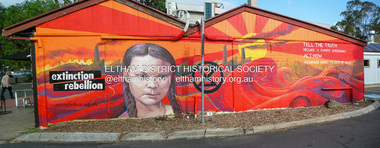 Eltham District Historical Society Inc
Photograph, Fay Bridge, Extinction Rebellion protest mural, Platform 3095, 965 Main Road, Eltham, 29 January 2020
Extinction Rebellion protest mural painted on the western wall of Platform 3095 cafe facing the railway station Prior to September 2016 a grouping of five trees were planted in the small garden bed on the western end of the cafe in two groups either side of the traffic sign which at that stage was the taller By October 2017 the five trees had doubled in height to about 1m above the roof line By April 2018 the trees were all about 2m above the roof line By August 2019 all five trees had been cut down and the wall was a mixture of paint patches from ongoing graffitti attacks By January 2020 the wall had been adorned with this mural which appears to have discouraged ongoing graffitti attacks but its message is tinged with irony that five healthy young trees were removed fay bridge collection, 2020-01-29, eltham, platform 3095, extinction rebellion -
 Eltham District Historical Society Inc
Photograph, Fay Bridge, Former cottage of Tom Ellis, 230 Kangaroo Ground-St Andrews Road, Kangaroo Ground, 13 November 2021
Tom Ellis was the great grandson of pioneer William Ellisfay bridge collection, 2021-11-13, kangaroo ground, kangaroo ground-st andrews road, tom ellis house -
 Eltham District Historical Society Inc
Photograph, Fay Bridge, Briar Hill Primary School, n.d
fay bridge collection, briar hill primary school -
 Eltham District Historical Society Inc
Photograph, Fay Bridge, Looking north towards Diamond Creek from the high point of Allendale Road, Diamond Creek, n.d
Situated opposite the driveway of 170 Allendale Road, Research, just east of where the Maroondah Aqueduct Trail crosses the roadfay bridge collection, allendale road, diamond creek, fences, research (vic.) -
 Eltham District Historical Society Inc
Photograph, Fay Bridge, Footbridge, Fort Knox Self Storage, 197 Sherbourne Road, Eltham, n.d
The footbridge which extended from the facility to the landscaped garden and water features is now gone. The footbridge and garden were previously part of a former hat factory in Sherbourne Road Eltham which has in the past been used for various purposes and presently a self storage business. The Karingal Yallock Creek passes through the front of the land and the creek environs are the subject of significant and unusual landscaping works, including some cascading water channels. Some of the landscaping was damaged by the Christmas Day floods of 2011, but the main elements remain intact. The landscaped area (as distinct from the factory itself) is the subject of a Heritage Overlay under the Nillumbik Planning Scheme. The basis of this overlay is a Heritage Report by Graeme Butler and Associates in 2006. As well as an assessment of the landscaped area, it includes one background information on the history of the site (although a complete history would require more research). The site was part of Crown Portion 3 of the Parish of Nillumbik that remained as the Montmorency Farm until early in the twentieth century. The 1911 subdivision of this farm created Lot 7 of some seven acres, which is the site of this factory. The Heritage Report lists the various owners of the site. From the rate records and aerial photos it is concluded that the site was used as an orchard and farmland until the 1940s. William F Crellin, orchardist, owned the site from 1912 to 1923. Then Edmund Williams owned it until 1951. In 1955 the site was owned by Rupert V. Kirsch and this is the name anecdotally associated with the hat factory, where the well-known brand of Fayrefield Hats were manufactured. There is some belief that this was built about the time of the Second World War and that hats for the armed forces were made there.fay bridge collection, eltham, fayrefield hat factory, foot bridge, sherbourne road, footbridge, fort knox eltham -
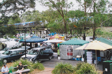 Eltham District Historical Society Inc
Photograph, Fay Bridge, Eltham Craft & Produce Market, Library Place, Eltham, n.d
fay bridge collection, eltham, eltham craft & produce market, eltham market, eltham railway trestle bridge, library place -
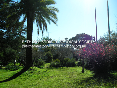
 Eltham District Historical Society Inc
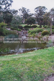
Photograph, Fay Bridge, Lake, Eltham Cemetery, 40 Mount Pleasant Road, Eltham, c.2009
Robert Boyle Landscape Design created the original design and construction of the lake in 1993. They are renowned local landscape designers and have carried out numerous projects at the Cemetery, including the major upgrades to the lakeside design in 2020. Title Lakeside Maintenance and Improvement Works Url https://www.elthamcemetery.com/item/25-lakeside-maintenance-and-improvement-works Description Improvement works to the lake and surrounding area July to October 2020.fay bridge collection, 2009, eltham, eltham cemetery, lake, mount pleasant road -
 Eltham District Historical Society Inc
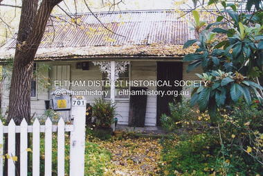
Photograph, Fay Bridge, Former Jarrold Cottage and Bootmaker's Shop, 701 Main Road, Eltham, n.d
Situated originally on the corner of the Dalton Street road reserve west of Main Road (now present-day Wingrove Park Trail), the former Jarrold Cottage (White Cloud) was purchased by Lena Skipper following Thekla Jarrold's death in 1943. It was built by William Jarrold in the early 1850s and was here that he married Hannah Coleman in 1856. The Bootmaker's shop was built by Thekla Jarrold in 1930 for use by her friend, John Clark, a local photographer who had boarded with the Jarrold family since about 1910. In 1930 he changed profession to a bootmaker and leather worker. The shop is one of only three remaining early 20th century shops in what was Little Eltham, the others being present-day San Antionio Barber Shop at 820 Main Road and Cafe Zen Den at 736 Main Road.fay bridge collection, bootmaker's shop, eltham, jarrold cottage, main road, shops, white cloud cottage, wingrove park trail