Showing 13428 items
matching golden-gate-bridge
-
 Ringwood and District Historical Society
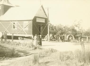
Photographs, 1979-80 MMBW pipe line project at Hubbard Reserve, North Ringwood � Track down to creek bridge
Part of a 43-photo record of the MMBW�s engineering feat in drilling a 12 inch pipe line up to 40 feet deep through rock hardened by volcanic action associated with geological fault that occurs along the line. The work took place from October 1979 to May 1980 on the southern boundary of Hubbard Reserve, North Ringwood. The collection was presented to the Ringwood Historical Research Group by J Clarke on 9th June 1980.E565 N12 13 May 1980 A43 My old track down to the bridge over the creek. The pipe line went to the right of the big tree 40-foot down. -
 Ringwood and District Historical Society
Photograph, Church of England relocation: About to cross bridge over Mullum Creek, Warrandyte Rd (undated)
Smaller photograph that appears to be the original from which this photograph was taken reads, "About to cross bridge over Mullum Creek, Warrandyte Rd. English Church" Appears to be Church of England. -
 Greensborough Historical Society
Photograph, Railway Gates at Grimshaw Street Greensborough, 1930c
Two women are standing at the railway crossing gates, ready to open or close the gates [Possibly Iredale family?]. Originally thought to be the rail crossing at Grimshaw Street and Old Greensborough Road. In 2023, there is doubt that this is the case due to the double rail line and building in background. Please contact the Society if you have any idea where this is located.Copy of photo of railway gates. Sepia.On back: "Godwill from Val Wilson"railway gates, rail crossing, iredale -
 Eltham District Historical Society Inc
Photograph - Digital Photograph, Monash Bridge, Hurstbridge, 23 January 2008
Monash Bridge spans the Diamond Creek at Hurstbridge. It was built in 1917 for the Shires of Heidelberg, Eltham and Whittlesea. It is considered Nillumbik Shire's finest engineered bridge and was construced by the engineering company of Sir John Monash. Covered under Heritage Overlay, Nillumbik Planning Scheme. Published: Nillumbik Now and Then / Marguerite Marshall 2008; photographs Alan King with Marguerite Marshall.; p117This collection of almost 130 photos about places and people within the Shire of Nillumbik, an urban and rural municipality in Melbourne's north, contributes to an understanding of the history of the Shire. Published in 2008 immediately prior to the Black Saturday bushfires of February 7, 2009, it documents sites that were impacted, and in some cases destroyed by the fires. It includes photographs taken especially for the publication, creating a unique time capsule representing the Shire in the early 21st century. It remains the most recent comprehenesive publication devoted to the Shire's history connecting local residents to the past. nillumbik now and then (marshall-king) collection, hurstbridge, monash bridge -
 Eltham District Historical Society Inc
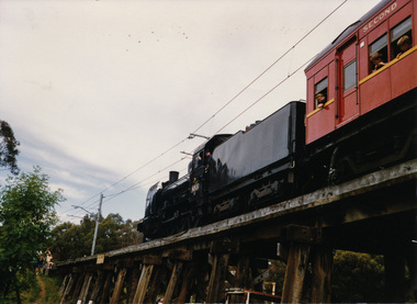
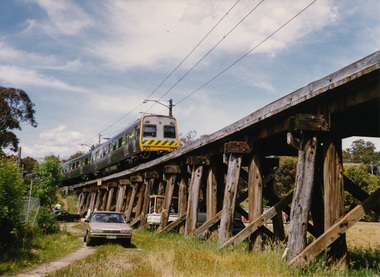
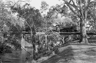
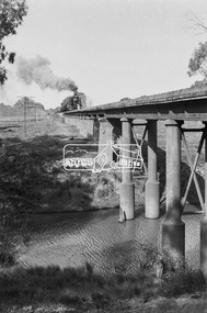
Photograph, Steam and electric trains on the the Trestle Bridge at Eltham, Nov 1992, 1992
Three colour photographs; one featuring an Hitachi electric commuter train and two of the Steamrail steam train which participated in the Shire of Eltham 1992 18th Community Festival as they crossed the Eltham Trestle Bridge. See also Photo 564.shire of eltham, festivals, trestle bridge, eltham, bridges, steamrail, steam train, hitachi electric train -
 Eltham District Historical Society Inc
Photograph, Steam and electric trains on the the Trestle Bridge at Eltham, Nov 1992, 1992
Three colour photographs; one featuring an Hitachi electric commuter train and two of the Steamrail steam train which participated in the Shire of Eltham 1992 18th Community Festival as they crossed the Eltham Trestle Bridge. See also Photo 564.shire of eltham, festivals, trestle bridge, eltham, bridges, steamrail, steam train, hitachi electric train -
 Bay Steamers Maritime Museum
Framed photograph, Lindsay Rex, S. T. Wattle on low loader passing under Bolte bridge, 22/10/2009
Photogtoraph taken during the removal of Wattle from the River Yarra to its temporary storage and restoration site at No 24 South Wharf, Port Melbourne. A very significant moment in the life of the Wattle as this was the first day of the major restoration project that continues from 2009 through 2012 aiming to finish in mid 2013. Prior to this restoration project there was a long lead up to find funding and resources to restore the Wattle and ensure that Wattle was not scrapped. The majority of this preparation and restoration work was and continues to be completed by volunteers.Gilded wooden frame around a colour photograph. Steam Tug Wattle facing aft on a low loader which is passing under the Bolte Bridge. This was towards the end of the tug's land journey from Victoria Harbour to 24 South Wharf.wattle, bolte bridge, river yarra, steam tug, restoration, low loader, port melbourne -
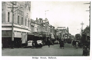
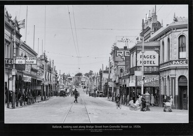 Ballarat Tramway Museum
Photograph - Black & White copy photograph, Rose Stereograph Co, "Ballarat looking east along Bridge St from Grenville St c1920s"
Original photograph by Rose Series Postcard P1711 with the original image held by the State Library of Victoria. Edited by Richard Conn. Purchased by the Museum.Provides information about the appearance of Bridge St during the 1920's, shows the tram tracks and overhead. Has in the view a number of road signs, shops, Super Spirit, Shell, Junction Service Station, motor vehicles, cyclists, Bon Marche, ladies with prams, a post box and Page's Bucks Head Hotel.Black & White copy photograph view A4 size, titled "Ballarat looking east along Bridge St from Grenville St c1920s", from a Rose Series Postcard, P1711. Original image held by the State Library of Victoria.ballarat, grenville st, bucks head hotel, bridge st, road signs, bon marche, tramways -
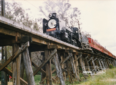
 Eltham District Historical Society Inc
Photograph, Steam locomotive K-158 crossing the railway bridge over the Campaspe River at Rochester, Victoria, c.November 1963, 1963
It is the railway bridge over the Campaspe River at Rochester, Vic. original to the construction of the line. It was taken late on a Saturday morning and shows the regular goods train of that period approaching, then crossing the bridge. I originally planned to take just one view. The approaching train was first then it was a rapid run back along the raised river bank to get the broadside shot. I had little time to steady myself or properly check camera settings, hence the slightly soft focus etc. The train would eventually continue over the Echuca Iron Bridge into NSW. I think its ultimate destination was Deniliquin but not sure.Digital TIFF file Scan of 35mm Ilford FP3 black and white negative transparencygeorge coop collection, k-158, k-class steam locomotive (vr newport workshops), railway bridge, campaspe river, rochester -
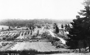 Eltham District Historical Society Inc
Negative - Photograph, Bridge Street, Eltham, c.1910
View from Maria Street (Main Road) along Bridge Street, Eltham, looking towards Montmorency. The house on the right at the corner of Susan and Bridge streets was owned for many years by the Hill family until Council bought it in the early 1960s. The house was built in the 1850s or 60s. The house on the left stood on what is now the southwest corner of Susan and Bridge Streets. The Braithwaite family was associated with this house. Orchards in the foreground either side of the Diamond Creek. The line of trees running up the hill to the left represents the Bolton street alignment. Based on hand writing of title on image compared with others, date is estimated at c.1910.This photo forms part of a collection of photographs gathered by the Shire of Eltham for their centenary project book,"Pioneers and Painters: 100 years of the Shire of Eltham" by Alan Marshall (1971). The collection of over 500 images is held in partnership between Eltham District Historical Society and Yarra Plenty Regional Library (Eltham Library) and is now formally known as the 'The Shire of Eltham Pioneers Photograph Collection.' It is significant in being the first community sourced collection representing the places and people of the Shire's first one hundred years.Digital image 4 x 5 inch B&W Negshire of eltham pioneers photograph collection, bolton steet, braithwaite, bridge, bridge street, bridge street bridge, eltham, hill family home, susan street, orchards -
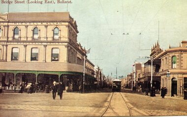 Ballarat Tramway Museum
Postcard, Bridge St (Looking East), Ballarat, c1905
Image is an ESCo tram leaving the intersection of Grenville St. and Bridge St. and proceeding east along Bridge St. Photo taken behind junction points. Has the Nicholl & Allan building on the left side of the photo and the Bucks Head Hotel on the right. Numerous people walking around the street. Shows overhead construction in the area. Title in top left-hand corner "Bridge St. (Looking East), Ballarat. On the rear is places for stamp, address and manufacturer's name in a fancy motif "WTP". Photo taken soon after opening, no roof-mounted destination boxes. See item 9010 for a printed version. yields information of Bridge St at Grenville St, c1905B&W print, laser print and scanned images of a coloured postcard lent to the BTM by Mr. Norm DePomeroy, August 1998 and Sovereign Hill reproduction of this card contained within a scrap book. See Notes for various image holdings and history.trams, tramways, esco, sturt st, postcards, bridge st., grenville st -
 Eltham District Historical Society Inc
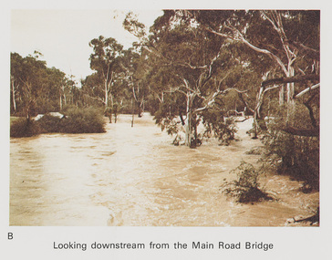
Work on paper (Sub-Item) - Photograph, Flooding, looking downstream from Main Road Bridge, Eltham 8 April 1977
Colour photograph. Looking downstream on the Diamond Creek from Main Road Bridge, Eltham , 8 April 1977. flood, diamond creek, flooding, main road, eltham -
 Malmsbury Historical Society
Photograph (Item), B/W Bridge Or Water Race Over A River, Malmsbury c1900
Associated with - Malmsbury Or Coolgardie? Buildings - "Bridge, Water Race" People - "Ellis, Florence Sarah; Ellis Godfrey William" -
 Clunes Museum
Photograph, CIRCA 1960
BLACK AND WHITE PHOTOGRAPH OF JUBILEE BRIDGE.JUBILEE OR QUEENS BRIDGE PRIOR TO 1960local history, photographs, bridges, jubilee bridge -
 Greensborough Historical Society
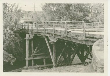
Article, Anne Paul, History of Maroondah Aqueduct Pipe Bridge over the Plenty River at Greensborough, by Anne Paul, 2012_03
The Maroondah Aqueduct pipe bridge, opened in 1891, was an important part of the system carrying water from the Maroondah Reservoir near Healesville to Melbourne. Most of the original system has been replaced by stainless steel pipes, the Greensborough section now running under the Plenty River since 1977. The original pipe bridge can still be seen over the Plenty River at Greensborough.2 p. typescriptaqueduct pipe bridge greensborough, maroondah aqueduct, melbourne water supply, anne paul -
 The Beechworth Burke Museum Research Collection
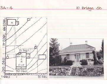
Card (Series) - Index Card, 10 Bridge Street, Beechworth, 1976
George Tibbits, University of Melbourne. Faculty of Architecture, Building and Town & Regional PlanningIndex system that support the research for Beechworth : historical reconstruction / [by] George Tibbits ... [et al]Arranged by street names of BeechworthEach index card includes: street name and number of property, image of property, allotment and section number, property owners and dates of ownership, description of the property according to rate records, property floor plan with dimensions.beechworth, george tibbitsbeechworth, george tibbits -
 Eltham District Historical Society Inc
Photograph, Tess Justine (Nillumbik Shire Council), Murray's Bridge over the Diamond Creek, Eltham North, 19 Feb 2022
Murray's Bridge over the Diamond Creek on the Diamond Creek Trail just prior to demolition and replacement with a new steel bridge. Heritage advice obtained by Nillumbik Shire Council, following a suggestion by the Eltham District Historical Society (EDHS), is that the original bridge appears to have been a simplified version of the Country Roads Board’s (CRB) standard timber bridge design of the early-to-mid 1920s. In c1990 Murray’s bridge was renovated with three recycled steel girders as part of a bike/pedestrian path in the reserve. During these alterations many parts of the bridge were removed, and some were replaced. Heritage advice indicates the condition of Murray’s bridge is poor. The remaining original parts are all in poor condition, with severe weathering, splitting and rot, especially to the stringers retained on the bridge. Heritage advice is that Murray’s Bridge does not have sufficient significance in the cultural history of the Nillumbik area to warrant inclusion in the Nillumbik Shire Heritage Overlay and also does not have sufficient significance as a rare survivor to warrant inclusion in the Nillumbik Shire Heritage Overlay. There are no indications in the historical record that this site was individually important to the cultural history of this area. EDHS is comfortable with the heritage advice provided to Council and has worked closely on this project with Council. EDHS has suggested some of the removed timbers be used in the vicinity of the bridge for landscaping and possibly seating, so as to retain these remnants close to the site of the original bridge, which is the last old timber bridge along the lower reaches of the Diamond Creek. Mary (Sweeney) Murray and John Wright Murray selected 80 acres, Lot C Section 16 and Lot 5 Section 17 Parish of Nillumbik, under an occupation license in 1866. John died in 1867 and freehold was granted to his son John in 1873. The farm was known as ‘Laurel Hill’. John Junior was an Eltham Shire councillor and sometime president from 1887 up until 1897. He added Lot A Section 16 to the farm in ca1888. John and his younger brother James arranged to rent/purchase Lot B Section 17, across Diamond Creek to the west, in ca1900. It appears that John and James farmed separately for a few years, with a new homestead built for James ad family on the high point of Lot B Section 17 in ca1910. John sold off Lot 5 Section 17 in 1912. When John died in 1912 James took over the land on both sides of the Diamond Creek. The old homestead on the west side of the Creek disappeared. A farm bridge over Diamond Creek from this period may have been located close to the northern boundary of the farm. John Langlands, owner of the farm known as ‘Ihurst’ on the west side of Diamond Creek to the south of the Murray’s land, died in 1907. In 1909 his land was then subdivided into 100 lots to become the ‘Glen Park Estate’. Other similar subdivisions of nineteenth century farms around Eltham in this period included the ‘Franktonia (or Beard’s) Estate’ to the northeast and ‘Bonsack’s Estate’ between Eltham and Greensborough. Soon after the opening of the railway extension line from Eltham to Hurstbridge in 1912, Glen Park and nearby residents including James Murray agitated for a railway station or siding to be located half-way between Eltham and Hurstbridge, so that the Glen Park residents who used the railway daily did not have to walk into the Eltham or Hurstbridge stations. Some believed Coleman’s Corner (opposite Edendale Farm) was an appropriate spot for the platform. James Murray was among those who thought the railway should be located on his land, closer to half-way between Eltham and Hurstbridge stations. The Railways Commissioners warned that the locals would have to fund these works themselves. The Glen Park Estate residents initially had difficulty accessing Eltham by road, with only an old low-level bridge over Diamond Creek at the south end of their estate. A new timber trestle bridge across the creek, now on Wattletree Road, was opened in 1915. Road access to the north was gained in 1927 when the new Murray’s Road, which crossed the Murray’s land, was built. Residents continued to agitate for a Glen Park station. By 1926 the Railways Commissioners’ preferred site was on the Murray’s land. They arranged an estimate of cost of a full-length platform. The estimate was too much for the locals, who in 1928 argued unsuccessfully for a shorter and hence cheaper platform. By 1929 Murray had agreed to donate the land, but the locals would still have to fund the works. Murray decided, unilaterally it would appear, to commence work on a timber trestle road bridge over Diamond Creek to link the new Murray Road to the proposed station. Late in 1929 he stopped work on the bridge, for reasons unknown, but started work again and completed the bridge in 1931. There is no further newspaper evidence of the campaign for the Glen Park station until 1939, when Murray and another local, Mr Maxwell, met the Railways Commissioner. The Glen Park locale now included 45 homes on the west side of the creek and 20 on the Eltham side. Most of the residents used the train every day. The Commissioner remained adamant that only a full-length platform could be built for safety reasons. It appears the campaign dissolved at this point. The increasing move to cars may have had an impact. There is no evidence of Murray’s bridge ever being connected to Murray’s Road, or of it having wide use for any purpose by locals. James Murray died in 1947 and the farm was taken over by his son James (Jim). Jim started to sell off parts of the farm in the 1980s, retaining a few acres around the ca1910 homestead and building a new house there. Recreation reserves were established along the creek. In ca1990 Murray’s bridge was renovated with steel girders as part of a bike/pedestrian path in the reserve. The old farmhouse was demolished in ca2014. * * * A theory posted on local community Facebook groups was that the bridge was built in the 1860s and was built to be more robust than was necessary for the movement of cows from one side of the creek to the other. It was suggested the robustness was necessary to support the weight of gold ore being transferred from a mine on Murray’s land to a railway siding near Murrays Bridge (presumably for transfer and processing at Diamond Creek). Perhaps this may have been one of the motivators for Murray, who really knows? Knowing when mining operations ceased on his land and how that fits the overall timeline would be useful but at the time the bridge was built, local gold production was minimal at best. The known facts are: • The railway line came to Eltham in 1902. • The extension of the railway from Eltham to Hurstbridge was constructed in 1912 so no railway line even existed through Murray's property until 1912 and the Victorian Railways maps at the time show no such siding on Murray’s property. • In 1923 a new company was formed in anticipation of the old Diamond Creek Gold Mine being re-opened. The mine had been previously closed and flooded. It was noted in the press at the time that the mine was within a mile of the railway. Nothing really came of this. • Construction of Murrays Bridge was commenced by James Murray in early 1929 in anticipation of a proposed flag station being nominated on his land, but work ceased shortly afterwards. The proposed flag station was commonly referred to as Glen Park as the residents of the Glen Park Estate wanted Option 1, located near them with the platform adjacent to Colemans corner. This was probably never going to fly as it was virtually in eyesight of Eltham station. Allandale Road was the third option, but the Commissioners' preferred option was No. 2 - on Murray's property. • The Railway Commissioners were not going to finance any such station and the works had to be funded by private landowners and residents, hence Murray investing in this himself. • Murray recommenced work two years later and finished his bridge in 1931 but unfortunately for him, the proposed flag station never eventuated. The bluestone siding you reference may well have been built by Murray as part of the proposed station platform. • Up until then, apart from the Main Road bridge, which was washed away in 1924, virtually all local crossings over the Diamond Creek were low lying bridges – Kaylocks Bridge at Brougham Street, Diamond Street bridge, Glen Park Road bridge. It is expected that Murray also had a low-lying bridge to connect his land either side of the creek. These were all washed away or severely damaged multiple times in the 1920s. Lessons were learnt, and Murrays Bridge appears to have been built in accordance with Country Road Board standards of the time. Flood damage was ongoing, and even more recently constructed raised bridges kept getting washed away, e.g., the new Wattle Tree Road bridge in 1958 just months after completion. Murray’s bridge was reinforced with steel some 30 years ago presumably to provide additional floodwater resistance, given the history of bridges disappearing in floodwaters. • In March 1932 it was reported in the Advertiser that there were still some prospectors operating around Eltham North who apart from further scarring the face of the earth over the previous two years had gained significant experience but little gold - hardly a driving factor for constructing a dedicated railway siding and bridge to transfer gold ore. It is far more probable that James Murray was hoping to have the railway station located on his property and invested his money by building the bridge to lead to it as well as a station platform. Had the station eventuated, it may well have driven up the value of his land for subdivision and new housing estates like the Glen Park Estate. That did not eventuate. Whilst the bridge was indeed old (90 years), the core structure being completed in 1931, it had been modified substantially from original and hence had no significant historic value – i.e., it was not a representative example of its type, construction, and age. Given that the bridge was not worthy of saving, the Eltham District Historical Society with Council’s support, and the Eltham Woodworkers group endeavoured to see what suitable sized timbers were salvageable to fabricate a commemorative seat. Unfortunately, the experts at the Woodworkers group were unable to salvage any suitable length/width timbers to fabricate the seat due to the presence of rot. Last remaining wooden trestle bridge on the Diamond Creek Trail just prior to demolition and replacementBorn digital image (27)diamond creek (creek), diamond creek trail, murrays bridge, ‘laurel hill’, john wright murray, mary (sweeney) murra, john murray jnr, james murray, john langlands, ‘ihurst’, ‘glen park estate’, beard's estate, franktonia, bonsack's estate, glen park estate, glen park railway station -
 Orbost & District Historical Society
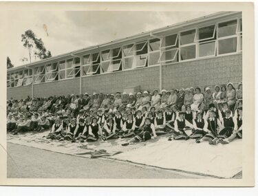
black and white photograph, 13 March 1962
This photograph was taken at the Golden Jubilee of Orbost High School in 1962.Orbost High School / Orbost Secondary College has played a significant part in the education of senior students in the Orbost district . It is the sole senior educational institution. This item is representative of its historyA black / white photograph of uniformed students and others sitting in front of the Orbost High School.on back - "Orbost H.S. Golden Jubilee 1962"orbost-high-school-jubilee -
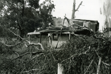 Ringwood and District Historical Society
Photograph-B&W, Wantirna Road Shack next to Dandenong Creek on East Side of Wantirna Road (near the bridge), 6/07/1989
Wantirna Road Shack next to Dandenong Creek on East Side of Wantirna Road (near the bridge). Has been there many years - maybe 40 and it is still there (18.9.1989). (Note this is NOT part of Hill's dairy but was in the same series of photographs so kept together).A shack next to Dandenong Creek / East side of Wantirna Road / Has been there many years - maybe 40 / It is still there (18.9.89) -
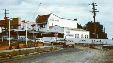
 Ballarat Tramway Museum
Postcard, "Bridge Street Ballarat", Original 1930's copy 2016
Yields information about the appearance of Bridge St in the late 1930's.Copy of black and white photograph of Bridge St, late 1930's with a single truck, possibly 12, in the viewpoint. Has a number of motor cars parked, looks west. In the view is a shop possibly with a sign "Grazers Butchers" and a "Join ANA Today". trams, tramways, bridge st, tram 671 -
 Eltham District Historical Society Inc
Photograph, Sketch of man on bridge over creek, 1971
Sketch of a man with a fishing pole standing on a bridge over a creek, stream or river in a bush setting. Unidentified artist and location.This photo forms part of a collection of photographs gathered by the Shire of Eltham for their centenary project book, "Pioneers and Painters: 100 years of the Shire of Eltham" by Alan Marshall (1971). The collection of over 500 images is held in partnership between Eltham District Historical Society and Yarra Plenty Regional Library (Eltham Library) and is now formally known as 'The Shire of Eltham Pioneers Photograph Collection.' It is significant in being the first community sourced collection representing the places and people of the Shire's first one hundred years.Digital imagesepp, shire of eltham pioneers photograph collection, fishing, creek, sketch, tranquil, unidentified, other areas, bush, outdoors, country life -
 Greensborough Historical Society
Slide, Fred Harris, Main Street, old river bridge Greensborough, 1949c
Taken about 1949, this colour slide shows Main Street Greensborough crossing the Plenty River via the 'old' bridge.1 photographic slide in yellow Kodak packet.Name of donor and title of slide written on outside of packetmain street greensborough, plenty river, main street bridge -
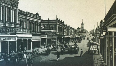 City of Ballarat Libraries
Photograph, Bridge Street, Ballarat
Bridge Street looking west Circa 1870-1880 from the Premier Album of Ballarat Views.. Pittard's Shoe Warehouse.bridge street, pittard's shoe warehouse, streetscape, commerical, ballarat, premier album of ballarat views -
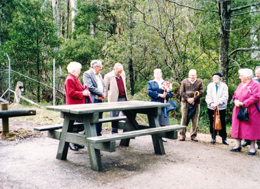 Eltham District Historical Society Inc
Photograph, Dedication of picnic table at Wilks Creek Bridge, Marysville by Marysville Historical Society, 13 October 1993, 13/10/1993
Wilks Creek Bridge was built in 1870. It was last used for heavy vehicle traffic in 1980 and left to decay until it was demolished in 2008. The last remnants of the timber structure were destroyed in the Black Saturday bushfire of 7 February 2009. [from EDHS Newsletter No. 93, November 1993:] OTHER NEWS A small group of members represented the Society at the opening of the picnic ground at the historic Wilks Creek Bridge at Marysville. The event included the launching of a booklet by our friend Ann Thomas on the history of the bridge which was located on the old Yarra Track coaching route between Eltham and Woods Point. Ann has donated a copy of the booklet to our Society.Two colour photographsactivities, marysville, wilks creek bridge -
 Eltham District Historical Society Inc
Photograph, Construction of new bridge over the Plenty River, Main Road, Lower Plenty, c.Aug. 1966
Construction of the Main Road bridge over the Plenty River. Includes structural members, construction personnel, vehicles and a Clarke mobile crane.Local significanceBlack and white printlower plenty, main road, plenty river, bridge, bridge construction, civil engineering, cranes, mobile cranes -
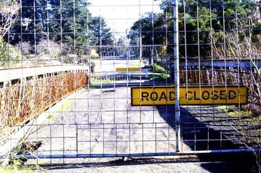 Greensborough Historical Society
Slide - Photograph, John Ramsdale, Old bridge at Lower Plenty under reconstruction: Slide 83, 1990s
Photograph shows a road construction area with "Road Closed" sign and temporary fencing. This is the old bridge at Lower Plenty under reconstruction.Part of the John Ramsdale collection of slides and audio visual material.Colour photograph scanned from slide.No maker's marks. No caption on slide.old lower plenty bridge, lower plenty bridge -
 Greensborough Historical Society
Photograph - Photograph - Digital Image, Main Street bridge Greensborough 1970s, 1970s
A colour photograph of the corner of Para Road and Main Street Greensborough in the 1970s, during the duplication and construction of the bridge over the Plenty River.Digital copy of colour photograph.main street greensborough, para road greensborough, plenty river bridge -
![Newspaper Clipping, Bridge is rail big effort [Rosanna], 11/04/2018](/media/collectors/4f729f5697f83e03086015b8/items/5aed3a8221ea670268548c06/item-media/5b4ad49921ea670f143ddf21/item-fit-380x285.jpg) Greensborough Historical Society
Greensborough Historical SocietyNewspaper Clipping, Bridge is rail big effort [Rosanna], 11/04/2018
The mammoth rail bridge has been installed across Lower Plenty Road in Rosanna by Level Crossing Removal Authority contractors.News article 1 page, black text and colour image .level crossing removal project, rail bridge, lower plenty road rosanna, rosanna station, hurstbridge rail line