Showing 12620 items
matching government-act
-
 Bendigo Historical Society Inc.
Map - JANIEMBER WEST : COUNTY OF BENDIGO, September 1955
Map. Janiember West, County of Bendigo. Loddon River, Janiember East, Powlett, Kinypanial, Jarklan. Welsh's Lagoon. By authority W.M. Houston, Government Printer, Melbourne. Drawn and reproduced at the Department of Lands and Survey, Melbourne, September 1955, Price 5/-. (number 66 in map cupboard 1)W.M. Houston, Government Printer, Melbourne.map, bendigo, janiember west -
Bendigo Historical Society Inc.
Map - TARNAGULLA : COUNTY OF BENDIGO, 1959
Map. Tarnagulla, County of Bendigo, Sheet 3, Kingower, Glenalbyn, Inglewood, Loddon River, Derby, Gladstone. Drawn and reproduced at the Department of Lands and Survey, Melbourne, 1959. Price 5/- per sheet. By authority A.C. Brooks, Government Printer, Melbourne. (number 35 in map cupboard 1)A.C. Brooks Government Printer, Melbourne.map, bendigo, tarnagulla -
Bendigo Historical Society Inc.
Map - KIMBOLTON : COUNTY OF BENDIGO, 1966
Map. Kimbolton, County of Bendigo. Eppalock, Lyell, Knowsley, Langwornor, Redesdale, County of Dalhouse, County of Rodney, Campaspe River, Coliban River,By authority A.C.Brooks, Government Printer, Melbourne. Drawn and reproduced at the Department of Lands and Survey, Melbourne, 1966, Price $1.00 (number 65 in map cupboard 1)A.C. Brooks, Government Printer, Melbourne.map, bendigo, kimbolton -
Bendigo Historical Society Inc.
Map - BAGSHOT : COUNTY OF BENDIGO, November 1948
Map. Bagshot. County of Bendigo, Huntly, Whirrakee, Egerton, Goornong, Ellesmere, Wellsford. Reedy Creek, Sandy Creek. Drawn and reproduced at the Department of Lands and Survey, Melbourne, Victoria. November 1948, Price 2/-. By authority J.J. Gourley, Government Printer, Melbourne. (number 46 in map cupboard 1)J.J. Gourley, Government Printer, Melbourne.map, bendigo, bagshot -
Bendigo Historical Society Inc.
Map - GOORNONG : COUNTY OF BENDIGO, September 1943
Map. Goornong, County of Bendigo, Egerton, Bagshot, Ellesmere, Muskerry, Campaspe, Nolan, Campaspe River, Town of Goornong. By authority : H.E. Daw, Government Printer, Melbourne. Drawn and reproduced at the Department of Lands and Survey, Melbourne, Victoria. September 1943, Price 2/-. (number 44 in map cupboard 1)H.E. Daw, Government Printer, Melbourne.map, bendigo, goornong -
 Flagstaff Hill Maritime Museum and Village
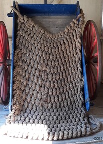
Equipment - Beach cart cover, Government of Victoria, 1860s
The load of heavy beach apparatus life saving equipment was held in place on the beach cart by the hand worked rope net cover. It would be stored in the Rocket House packed and ready to use for practice or rescue. Beach apparatus equipment - In the mid-1800s the equipment could include a line throwing set, coiled line in wooden carrying case, rockets, cartridges, breeches buoy, hawser and traveller block, line-throwing pistol, beach cart, hand barrow, sand anchor, crotch pole, and tools such as spade, pick, mallet and hawser cutter. Around the 1860s Warrnambool had a Rocket House installed beside the Harbour. Saving lives in Warrnambool – The coastline of South West Victoria is the site of over 600 shipwrecks and many lost lives; even in Warrnambool’s Lady Bay there were around 16 known shipwrecks between 1850 and 1905, with eight lives lost. Victoria’s Government responded to the need for lifesaving equipment and, in 1858, the provision of rocket and mortar apparatus was approved for the lifeboat stations. In 1859 the first Government-built lifeboat arrived at Warrnambool Harbour and a shed was soon built for it on the Tramway Jetty, followed by a rocket house in 1864 to safely store the rocket rescue equipment. In 1878 the buildings were moved to the Breakwater (constructed from 1874-1890), and in 1910 the new Lifeboat Warrnambool arrived with its ‘self-righting’ design. For almost a hundred years the lifesaving and rescue crews, mostly local volunteers, trained regularly to rehearse and maintain their rescue skills. They were summoned when needed by alarms, gunshots, ringing bells and foghorns. In July 1873 a brass bell was erected at Flagstaff Hill specifically to call the rescue crew upon news of a shipwreck. Some crew members became local heroes but all served an important role. Rocket apparatus was used as recently as the 1950s. This cover was used with the beach cart. The cart is significant for its connection with local history, maritime history and marine technology. Lifesaving has been an important part of the services performed from Warrnambool's very early days, supported by State and Local Government, and based on the methods and experience of Great Britain. Hundreds of shipwrecks along the coast are evidence of the rough weather and rugged coastline. Ordinary citizens, the Harbour employees, and the volunteer boat and rescue crew, saved lives in adverse circumstances. Some were recognised as heroes, others went unrecognised. In Lady Bay, Warrnambool, there were around 16 known shipwrecks between 1850 and 1905. Many lives were saved but tragically, eight lives were lost.Rectangular rope cover, hand worked for the purpose of covering the beach cart. The cover is made from heavy rope in a pattern that looks similar to crochet. A loop has been worked into each corner.flagstaff hill, warrnambool, maritime village, maritime museum, shipwreck coast, great ocean road, flagstaff hill maritime museum and village, lady bay, warrnambool harbour, port of warrnambool, shipwreck, life-saving, lifesaving, rescue crew, rescue, rocket rescue, rocket crew, beach rescue, rescue equipment, rocket rescue equipment, marine technology, lifeboat, volunteer lifesavers, volunteer crew, lifesaving rescue crew, rocket apparatus, stranded vessel, rocket rescue apparatus, beach apparatus, life jacket, rocket shed, rocket line, beach rescue set, rocket set, beach cart, hand barrow, welsh hand barrow, harbour board, government of victoria, harbour master, l.s.r.c., lsrc, rocket house -
 Whitehorse Historical Society Inc.
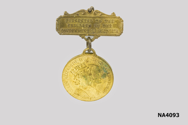
Medal, 1954
Donated by Margaret ScarlettGilt Medal on gilt bar & pin. Medal is of the Royal Visit to Victoria in 1954 & was presented to the children by the Government.(MEDAL) Queen Elizabeth 11 Duke of Edinburgh|E11R Royal Visit Victoria|(BAR) Presented to the Children by the Government of Victorianumismatics, medals - commemorative -
 Bendigo Historical Society Inc.
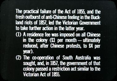
Slide - DIGGERS & MINING. THE CHINESE ON THE GOLD FIELDS, c1857
Diggers & Mining. The Chinese on the Gold Fields. Slide: The practical failure of the Act of 1856, and the fresh outburst of anti-Chinese feeling in the Buckland riots of 1857, led to Victorian Government to take further action in the latter year. (1) A residence fee was imposed on all Chinese in the colony (one pound per month - ultimately reduced, after Chinese protests, to four pound per year). (2) The co-operation of South Australia was sought, and , in 1857, the government of that colony passed a restriction act similar to the Victorian Act of 1855. Markings: 21. Used as a teaching aid.hanimounteducation, tertiary, goldfields -
 National Wool Museum
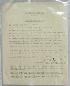
Letter
Authority from Rupert Vance Moon, licenced Real Estate Agent of Dennys Lascelles, for Norman George Cooper of Cobden to act as his sub-agent.Authority from Rupert Vance Moon, licenced Real Estate Agent of Dennys Lascelles, for Norman George Cooper of Cobden to act as his sub-agent.wool sales - auction system, dennys, lascelles limited, moon, mr rupert vance - dennys lascelles limited wilson, mr norman george -
Bendigo Historical Society Inc.
Map - COSTERFIELD : COUNTY OF BENDIGO, 29-10-29
Map. Costerfield, County of Bendigo, Counties of Dalhousie & Rodney, Dargile, Moormbool West, Warrowitue, Heathcote, Town of Costerfield, Dalhousie. By Authority H.J. Green, Government Printer, Melbourne. Drawn and reproduced at the Department of Lands and Survey, Melbourne. 29-10-29. Price 2/-. (number 92 in map cupboard 1)H.J. Green, Government Printer, Melbourne.map, bendigo, costerfield -
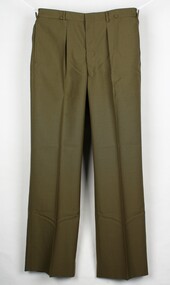 Montmorency/Eltham RSL Sub Branch
Uniform - Trousers, Khaki, Summer Dress, 1989
Wool and polyester khaki dress trousers. Two pleats at the front. Fob pocket on the right front. Front zip with metal closure and button tag.. Pockets on the left and right hips. Pocket on the back right side with hidden button and button hole.Seven belt loops on waist band. Four small horizontal loops on the waist band, two at the front and two at the back. Label on the inside on the lining of the back pocket states - A.G.C.F. (Australian Government Clothing Factory) Vic 1989. 8405.66.018.5545. Macquarie 89. Batch U. Size 87.5L W.87.5 IL.82 Army No. Name. Dry clean only. re press on original creases use damp cloth or medium to hot steam iron. White tag on the waist band on the right back stating - Size 87.5L. Tag on the right hand side on the back above the pocket stating - This tag is for identification only. Please remove before wearing. Docket No. 1106512 Order No. 29743836 Size 87.5L Garment No. 20851A Remarks 6I11Manufacturer - A.G.C.F. VIC 1989polyesters, dress trousers, wool polyester -
Bendigo Historical Society Inc.
Map - MARONG : COUNTY OF BENDIGO, June 1953
Map> Marong, County of Bendigo, Nerring, Sandhurst, Lockwood, Shelbourne, Woodstock, Leichardt, Bullock Creek, Fletcher Creek, Township of Marong, Bendigo Railway Line, Marong Railway Station, Crusoe Aqueduct. Drawn and reproduced at the Dept. of Lands and Survey, Melbourne, Victoria. June 1953. Price 2/-. By authority W.M. Houston, Government Printer. (number 74 in map cupboard 1)W.M. Houston, Government Printer.map, bendigo, marong -
Bendigo Historical Society Inc.
Map - DIGGORRA PARISH : COUNTY OF BENDIGO, 6-9-21
Map. Parish of Diggorra, County of Bendigo, Parish of Bamawm, Rochester West, Pannoomilloo, Warragamba, Minto, Egerton, Elmore, Northern Railway, Parish of Ballendella. Elmore /Cohuna Railway. Photo-Lithographed at the Department of Lands and Survey, Melbourne by W.J. Butson, 6-9-21, Price 1/-.. By authority A.J. Mullett, Government Printer. (number 57 in map cupboard 1)A.J. Mullett, Government Printer.map, bendigo, diggorra -
Bendigo Historical Society Inc.
Map - DERBY : COUNTY OF BENDIGO, 1959
Map. Derby, County of Bendigo, Inglewood, Tarnagulla, Woodstock, Leichardt, Bridgewater, Loddon River, Bendigo Railway, Calder Highway, Maldon to Bridgewater Road.By authority A.C. Brooks, Government Printer, Melbourne. Drawn and reproduced at the Department of Lands and Survey, Melbourne, 1959. Price 5/-. (number 59 in map cupboard 1)A.C. Brooks, Government Printer, Melbourne.map, bendigo, derby -
Bendigo Historical Society Inc.
Map - CALIVIL : COUNTY OF BENDIGO, 12-12-22
Map. Calivil, County of Bendigo, Mologa, Jarklan, Pompapiel, Talambe, Hayanmi. Calivil Creek, Seven Months Creek. Photo-Lithographed at the Department of Lands and Survey, Melbourne by W.J. Butson,12-12-22, Price 1/-. By authority A.J. Mullett, Government Printer, Melbourne. (number 56 in map cupboard 1)A.J. Mullett, Government Printer, Melbourne.map, bendigo, calivil -
Bendigo Historical Society Inc.
Map - EGERTON : COUNTY OF BENDIGO, 29-5-23
Map. Egerton, County of Bendigo, Minto, Giggorra, Elmore, Nolan, Goornong, Bagshot, Whirrakee, Bendigo Creek, Round Creek. By authority A.J. Mullett, Government Printer, Melbourne.Photo-Lithographed at the Department of Lands and Survey, Melbourne by W.J. Butson, 29-5-23. Price 1/-. (number 48 in map cupboard 1)A.J. Mullett, Government Printer, Melbourne.map, bendigo, egerton -
Bendigo Historical Society Inc.
Map - CROSBIE : COUNTY OF BENDIGO, 1970
Map. Crosbie, County of Bendigo, County of Rodney, Toolleen, Weston, Dargile, Knowsley East, Redcastle, Township of Toolleen, Northern Highway, Mt.Pleasant Creek. By Authority R.H. Rixon, Government Printer, Melbourne. Drawn and reproduced at the Department of Lands and Survey, Melbourne. 1970. Price $1.00. (number 114 in map cupboard 1)R.H. Rixon, Government Printer, Melbourne.map, bendigo, crosbie -
Bendigo Historical Society Inc.
Map - WESTON : COUNTY OF BENDIGO : COUNTY OF RODNEY, 4-5-21
Map. Weston, County of Bendigo, County of Rodney, Muskerry, Crosbie, Knowsley East, Knowsley, Axedale. Back Creek. By authority A.J. Mullett, Government Printer, Melbourne. Photo-Lithographed at the Department of Lands and Survey, Melbourne by W.J. Butson 4-5-21. Price 1/-. (number 108 in map cupboard 1)A.J. Mullett, Government Printer, Melbourne.map, bendigo, weston -
Bendigo Historical Society Inc.
Map - SALISBURY WEST : COUNTY OF BENDIGO, 3-3-1944
Map. Salisbury, County of Bendigo, County of Gladstone, Powlett, Yarrayne, Bridgewater, Inglewood, River Loddon, Bullabul Creek, Glenalbyn, Kurting. By Authority H.E. Daw, Government Printer, Melbourne. Drawn and reproduced at the Department of Lands and Survey, Melbourne., 3-3-1944. Price 5/-. (number 94 in map cupboard 1)H.E. Daw, Government Printer, Melbourne.map, bendigo, salisbury west -
Bendigo Historical Society Inc.
Map - SEDGWICK : COUNTY OF BENDIGO, 18-12-20
Map. Sedgwick, County of Bendigo,Strathfieldsaye, Mandurang, Sutton Grange, Lyell, Eppalock. Photo-Lithographed at the Department of Lands and Survey, Melbourne by W.j. Butson 18-12-20, Price 1/-. By authority A.J.Mullett, Government Printer, Melbourne. (number 29 in map cupboard 1)A.J. Mullett, Government Printer,Me;bourne.map, bendigo, sedgwick -
Whitehorse Historical Society Inc.
Document, Electoral handbook 1949 federal election, 1949
Electoral handbook for the 1949 federal election.Electoral handbook for the 1949 federal election. This book contains the main provisions of the Commonwealth Electoral Act 1918 - 1949 for the use of endorsed candidates, party members, organizers and canvassers.Electoral handbook for the 1949 federal election. politics and government, australian government, elections -
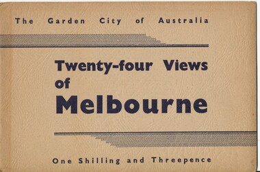 Melbourne Tram Museum
Book, Victorian Government Information Bureau?, "The Garden City of Australia / Twenty-four views of Melbourne", c1950
Book, brown cover patterned (Deer skin?), titled "The Garden City of Australia / Twenty-four views of Melbourne" with 24 pages (smaller than cover) printed pages stapled inside. Inside front cover is a map of Melbourne, with specific buildings marked, inside rear cover - Where to go in Melbourne, General Information and Sight seeing tours. On rear cover is printer details. Page Photo details by 1 Skyline of the City of Melbourne from Yarra Bank Victorian Railways 2 Collins St from Spring St (with trams) ditto 3 Princes Bridge, River Yarra ditto 4 St Kilda Rd from Flinders St Station ditto 5 St Pauls Cathedral ditto 6 Bourke St Shopping Centre - with double deck buses no details of photographer 7 Elizabeth St - with trams and buses Victorian Railways 8 Swanston St with modern skyscrapers (Collins) ditto 9 Aerial view, city of Melbourne ditto 10 Parliament House ditto 11 Public Library, Museum and Art Gallery ditto 12 St Kilda Rd, Looking towards the City trams 772 and W2 ditto 13 Kings Domain - Pioneer Monument ditto 14 Royal Melbourne Hospital - with back view inset ditto 15 Alexandra Gardens and the Shrine of Remembrance ditto 16 Alexandra Gardens and Government House ditto 17 Captain Cook's House - Fitzroy Gardens ditto 18 Albert Park Lake no details of photographer 19 Melbourne Boys School, MacRobertson's Girls High School and Melbourne Uni - no details of photographer 20 Scene in the Botanical Gardens Victorian Railways 21 Aerial view of St Kilda with Brighton in background Victorian Railways 22 Melbourne Cricket ground, taken during the testimonial match to Sir Donald Bradman - no details 23 Queen Victoria Memorial Hospital and Exhibition Buildings and Aquarium - Victorian Railways 24 Dandenong - Showing Silvan Dam Victorian Railways The testimonial match took place in Melbourne during December 1948 (Reference Sir Donald Bradman Museum). Possibly arranged by the Victorian Government Information Bureau given the number of Victorian Railways photographs.trams, tramways, melbourne, st kilda rd, swanston st, bourke st, victorian railways, flinders st station, gardens -
Bendigo Historical Society Inc.
Map - CAMPASPE : COUNTY OF BENDIGO, 1964
Map. Campaspe, County of Bendigo, County of Rodney, Runnymede, Nolan, Muskerry, Toolleen, Colbinabbin, Campaspe River, Goornong, Mount Pleasant Creek. By authority A.C. Brooks, Government Printer, Melbourne. Drawn and reproduced at the Department of Lands and Survey, Melbourne. 1964. Price 10/- per sheet. (number 112 in map cupboard 1)A.C. Brooks, Government Printer, Melbourne.map, bendigo, campaspe -
Bendigo Historical Society Inc.
Map - PARISH OF SHELBOURNE : COUNTY OF BENDIGO, 11-12-15
Map. Parish of Shelbourne, County of Bendigo, Marong, Lockwood, Ravenswood, Bradford, Laanecoorie, Woodstock. Photographed at the Department of Lands and Survey, Melbourne by W.J.Butson, 11-12-15. Price 1/-. By authority Albert J. Mullett, Government Printer, Melbourne. (number 32 in map cupboard 1)Albert J. Mullett, Government Printer, Melbourne.map, bendigo, shelbourne -
Bendigo Historical Society Inc.
Map - MARONG : COUNTY OF BENDIGO, June 1953
Map. Marong, County of Bendigo, Nerring, Sandhurst, Lockwood, Shelbourne, Woodstock, Leichardt, Fletcher Creek, Bullock Creek, Township of Marong, Marong Railway Station, Bendigo Railway Line, Spring Creek, Crusoe Aqueduct. By authority W.M. Houston, Government Printer. Drawn and reproduced at the Department of Lands and Survey, Melbourne, Victoria. June 1953. Price 2/-. (number 73 in map cupboard 1)W.M. Houston, Government Printermap, bendigo, marong -
 Bendigo Historical Society Inc.
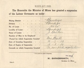
Document - MCCOLL, RANKIN AND STANISTREET COLLECTION: SUSPENSION OF LABOUR COVENANTS
18 large forms (form 5) headed: Mines Act 1928, The Honorable the Minister of Mines has granted a Suspension of the Labour Covenants as under - . These were granted to various companies for a period of 1 to 3 months, some of the reasons being - to complete negotiations, to raise capital, to re-organise, and the lease is held on behalf of a London Company. Items date range from 1941 to 1942. Some of the places to which these apply are; Bendigo, South Wattle Gully Coy N.L. Castlemaine Vic 3450, Central Wattle Gully Coy N.L., North Hustlers G. M. Coy N.L., Elphinstone, Chewton, South Wattle GullyCoy N.L.,Sandhurst, Forbes Carshalton Gold Mining Coy N.L., Gold Dumps Pty Ltd, Huntly & Nerring.Government Printergold, mining, suspension of labour covenants, gold mining, suspension of labour covenants -
Bendigo Historical Society Inc.
Map - PANNOOBAMAWM : COUNTY OF BENDIGO, 1957
Map. Pannoobamawm, County of Bendigo, Turrumberry, Terrick Terrick East, Wanurp, Pannoomilloo, Bamawm, Elmore to Cohuna Railway, McColl Station Ground, Lockington Station Ground. By authority W.M. Houston, Government Printer, Melbourne. Drawn and reproduced at the Department of Lands and Survey, Melbourne 1957. Price 2/-. (number 80 in map cupboard 1)W.M. Houston, Government Printer, Melbourne.map, bendigo, pannoobamawm -
Bendigo Historical Society Inc.
Map - MARONG : COUNTY OF BENDIGO, 25-6-25
Map. Marong, County of Bendigo, Nerring, Sandhurst, Lockwood, Shelbourne, Woodstock, Leichardt, Kangaroo Flat Rifle Range, Crusoe Aqueduct. By authority H.J. Green, Government Printer, Melbourne. Photo-Lithographed at the Department of Lands and Survey, Melbourne by W.J. Butson 25-6-25.Price 1/-. (number 75 in map cupboard 1)H.J. Green, Government Printer, Melbourne.map, bendigo, marong -
Bendigo Historical Society Inc.
Map - SALISBURY WEST : COUNTY OF BENDIGO, 24-6-24
Map. Salisbury, County of Bendigo, County of Gladstone, Powlett, Yarrayne, Bridgewater, Inglewood, Glenalbyn, Kurting, River Loddon, Bulabul Creek. By authority A.J. Mullett, Government Printer, Melbourne. Photo-Lithographed at the Department of Lands and Survey, Melbourne by W.J. Butson, 24-6-24. Price 1/-. (number 116 in map cupboard 1)A.J. Mullett, Government Printer, Melbourne.map, bendigo, salisbury west -
Bendigo Historical Society Inc.
Map - MUSKERRY : COUNTY OF BENDIGO, 1962
Map. Muskerry, County of Bendigo, County of Rodney, Goornong, Ellesmere, Axedale, Weston, Crosbie, Toolleen, Campaspe, Forest or Mannering Creek, Back Creek, Campaspe River. By authority A.C. Brooks, Government Printer, Melbourne. Drawn and reproduced at the Department of Lands and Survey, Melbourne, 1962. Price 2/-. (number 110 in map cupboard 1)A.C. Brooks, Government Printer, Melbourne.map, bendigo, muskerry