Showing 1604 items
matching off road
-
 Running Rabbits Military Museum operated by the Upwey Belgrave RSL Sub Branch
Lid
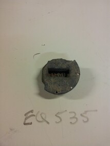
Lid off 44 gal drum - Banka Banka Staging Camp, Alice Springs,equipment, ww2, army -
 Running Rabbits Military Museum operated by the Upwey Belgrave RSL Sub Branch
Dust Off
"Dust Off" Army Aeromedical Evaquation In Vietnamdocuments, vietnam, general -
 Queenscliffe Maritime Museum
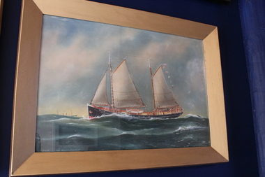
Painting - Water colour painting of the ketch Falie, Falie, 1934
Arthur V Gregory b.1867, d.1957 worked from studio at 326 Albert Road South Melbourne established by his father G F Gregory in 1852. FALIE operated for many years as a cargo ship, largely around South Australia where it formed a strong regional association. During World War II, FALIE was requisitioned by the Royal Australian Navy for service, and was on patrol off Sydney Heads during the mini-submarine raid on Sydney Harbour in May 1942. After the war it returned to commercial service and was retired in 1982. It was then the last working ship representing the South Australian ketch fleet, and along with NELCEBEE ( HV000419) one of the last two working sail powered cargo vessels in South Australia.Water colour painting in painted gilt frameFalie off Cape Schank A.V. Gregory 1934falie, a.v. gregory, water colour, painting -
 Queenscliffe Maritime Museum
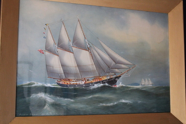
Painting - Water colour painting of the schooner Argosy Lemal, Argosy Lemal, c. 1930's
Arthur V Gregory b.1867, d.1957 worked from studio at 326 Albert Road South Melbourne established by his father G F Gregory in 1852. As Argosy Lemal the ship served as one of the early United States Army communications ships from 1942–1949.Water colour painting in painted gilt frameArgosy Lemal off Cape Otway A.V. Gregorya.v. gregory, water colour, argosy lemal -
 Bendigo Historical Society Inc.
Document - Marong racecourse
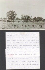
Copied from a copy of an original photo loaned to me by Mrs. Jean Grimson. The photo shows patrons arriving at a race meeting being held at the racecourse fronting the Loddon Valley Highway opposite where Mrs. Grimson was living in 1985. The photo was thought to be taken around 1920? The Swan Hill train used to slow down for race patrons to jump off and enter the course from the "rear". The course was later transferred to land fronting the Myers Flat - Marong Road & Williams Road and with a railway siding on the Bendigo side of the railway crossing Myers flat (behind the Allies Hotel). Fron Q. C. Binks 29/01/2001.historic referenceHistoric photo circa 1920.race goers entering marong racecourse circa 1920, races -
 Ballarat Tramway Museum
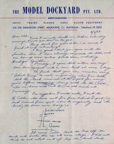
Letter - from Peter Duckett to Wal Jack re Ballarat Sprinkler car tank, Peter Duckett, 8/3/1958
Wal Jack had an extensive range of correspondents throughout Australia and the world who often prepared extensive notes and records for him. This letter from Peter Duckett, the owner and proprietor of the Model Dockyard, dated 8/3/1955 discusses the water tank on the Ballarat ESCo sprinkler tram and its disposal history, First sold to a Mr Colters of Forest St and then sold to a lady in Invermay. Also compares the Ballarat tank to that of Bendigo. Finishes off with a discussion about his visit to Ballarat the previous weekend and the traffic on the road.Demonstrates some of the correspondence that Wal Jack received from around the world and that of Peter DuckettLetter on The Model Dockyard letterhead, printed quarto sheet, hand written by Peter Duckett dated 8/3/1955 - two sheets.letters, wal jack, peter duckett, sprinkler tram, water tanks, ballarat, bendigo, model dockyard -
 Kew Historical Society Inc
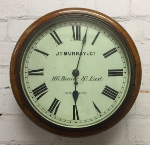
Functional object, Jas Murray & Co, Wall Clock & Key, 1860s
The clock was purchased from Jas Murray & Co. of 107 Bourke Street East, Melbourne by Francis Barnard. James Murray & Co were well known clock and watchmakers operating from premises in London with branches in Calcutta and Melbourne. They were watchmakers and jewellers in Melbourne from 1860 to 1888. Francis Barnard established Barnard’s Pharmacy on the corner of Bulleen Road (later renamed High Street) and Cotham Road in 1857. In the early 1860s, after purchasing the clock, he placed it in his pharmacy where it could be seen by passers by. When he relocated across the road to 49 Bulleen Road (now 167 High St.) in 1880 he took the clock to the new premises. He maintained the accuracy of the clock so that local residents consulted it for the correct time, even after the Post Office building with its clock tower was opened in 1888. When Francis Barnard retired, his son took over the pharmacy. In 1925, the Barnard Pharmacy was sold to David Paton. The Paton’s were at first puzzled why people constantly peered in the door until they realised that the timepiece was the drawcard. When David Paton died in 1941, his widow sold the pharmacy but took the clock with her to her new florist shop at 145 High Street. When Mrs Paton retired in 1953, she took the clock to her home in Boronia. In 1973 her daughter donated the clock to the Kew Historical Society.Significant locally to Kew as an example of a timepiece that was used by the local community during the 19th century to tell the time.Barnard’s clock is a typical wall clock of the nineteenth century, variants of which could be seen in shops, offices, public buildings and stations. It has a mahogany case with a moulded wooden bezel encasing a hinged brass bezel housing the glass face which protects the dial and hands when working. The clock face has an off-white hand painted tin dial with black painted Roman numerals. The hands are black painted metal; the hour hand has a wide spade shaped point whilst the minute hand is much thinner. ‘Jas Murray & Co’ is painted above the centre, with ‘107 Bourke Street East’ and ‘Melbourne’ below, with the key hole in between. The clock movement is a fuse chain attached to a brass mainspring barrel which powers the pendulum for eight days. This is housed within a rectangular wooden casing with a convex curved base housing a hinged door giving access to the pendulum which is attached to the back of the clock by four wooden pegs.Jas Murray & Co / 107 Bourke St East / Melbournefrancis barnard, f g a barnard, high street - kew (vic), pharmacies - kew (vic), clocks, paton's pharmacy --- kew (vic.), bulleen road -- kew (vic.) -
 Kew Historical Society Inc
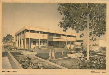
Drawing, AK Lines, Macfarlane & Marshall, Kew Civic Centre, c.1970
The Kew Civic Centre (A K Lines, MacFarlane & Marshall, 1972) was built next to the Kew Civic Hall (A C Leith & Bartlett, 1960) on the site of the former mansion Ordsall (later renamed South Esk). Whereas the entrance to the Civic Hall was positioned off Civic Drive, the main entrance to the Civic Centre faced Cotham Road, as shown in the undated perspective drawing of the proposed building. The Civic Hall was used for public functions and performances, while the Civic Centre was used for civic offices. It also contained the Council Chamber. The building opened in 1972, following the relocation of the councillors and council officers from the former Town Hall in Walpole Street (now a Woolworth's supermarket). Following the amalgamation of the former City of Kew into the City of Boroondara in 1994, the Civic Centre was sold to Trinity Grammar School. The exterior of the Centre has been modified by Trinity Grammar.A report for Heritage Victoria (date) describes how two architectural firms dominated the designs for new civic buildings in Victoria during the post war period. The report claims that: "An interesting sub-theme in the erection of post-war municipal offices in Victoria is that a considerable proportion were designed by the same three or four Melbourne-based architectural firms, who established themselves as the leading specialists in this type of work. The two most prolific firms in this regard were A K Lines, MacFarlane & Marshall, and A C Leith & Bartlett; both, in fact, had made names for themselves as designers of local government offices prior to the Second World War. Lines' office, for example had designed the Eltham Shire Offices in 1941, while Leith's firm had been responsible for the celebrated Heidelberg Town Hall in 1937). Both practices parleyed this early experience into a lucrative post-war career, designing numerous municipals offices well into the 1970s." (Survey of Post-War Built Heritage in Victoria, Built Heritage Pty Ltd, 2010.) The perspective drawing importantly captures the original design and function of the exterior of the building and its public entrance.Hand-coloured perspective sketch of the new Kew Civic Centre, completed in 1972 to designs by A K Lines, MacFarlane & Marshall; and located on the corner of Charles Street and Cotham Road, Kew. The sketch represents the front elevation of the building and its relation to the preexisting Kew Civic Hall at right. The three storey building features strong vertical concrete buttresses that extend across the three levels. KEW CIVIC CENTRE / A K LINES, MACFARLANE & MARSHALLkew civic centre, a.k. lines, macfarlane & marshall, architectural drawings, civic buildings -- kew (vic.), town hall -- kew (vic) -
 Kew Historical Society Inc
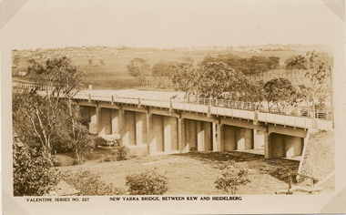
Postcard, Valentine Publishing Co Pty Ltd, New Yarra Bridge, Between Kew and Heidelberg, 1926-1930
Without bridges, Kew remained cut off from the City of Melbourne, only being accessible by Punt. Private and public bridges were constructed from the 1850s, beginning with the Hawthorn Bridge linking Bridge and Burwood Roads. A bridge across the Yarra at Burke Road was created as early as 1873. Since that first wooden bridge, a number of later bridges, typically on concrete pylons have been built, in 1926 and again during the 1970s.Angle view of the new Yarra bridge [ie. The Burke Road bridge] taken from the Kew side, showing the bridge’s structure. Trees line the river’s edge. In the distance can be seen a distant line of houses stretching to the horizon. The river appears to have an S-shaped bend beyond the bridge. The postcard, No. 227, was produced by the Valentine Publishing Co. Pty Ltd., of Queen Street, Melbourne.burke road bridge - kew (vic), bridges - kew (vic) -
 Kew Historical Society Inc
Photograph, J F C Farquhar, The Yarra in Hyde Park, 1891
At the beginning of the 1890s, the Kew businessman and Town Councillor, Henry Kellett, commissioned J.F.C. Farquhar to photograph scenes of Kew. These scenes included panoramas as well as pastoral scenes. The resulting set of twelve photographs was assembled in an album, Kew Where We Live, from which customers could select images for purchase.The preamble to the album describes that the photographs used the ‘argentic bromide’ process, now more commonly known as the gelatine silver process. This form of dry plate photography allowed for the negatives to be kept for weeks before processing, hence its value in landscape photography. The resulting images were considered to be finely grained and everlasting. Evidence of the success of Henry Kellett’s venture can be seen today, in that some of the photographs are held in national collections.It is believed that the Kew Historical Society’s copy of the Kellett album is unique and that the photographs in the book were the first copies taken from the original plates. It is the first and most important series of images produced about Kew. The individual images have proved essential in identifying buildings and places of heritage value in the district.Hyde Park is now a small recreation reserve bordered by Willsmere and Kilby Roads and White Avenue. In 1982, Hyde Park was cut off from the Yarra River by the construction of the Eastern Freeway. The building of the latter was to transform the natural landscape, including the Yarra, as well as Hyde Park. The construction of the Freeway makes it difficult to view the scene with the photographer’s eye. Today’s Hyde Park is located on land purchased in 1847 by John Cowell, and in 1851 Catherine Cowell, yet the scene selected by the photographer may well have been located on farmland owned by the Wills family. Farquhar’s point-of-view emphasises both the pastoral and recreational elements of the scene: the grazing cows, three boys, and in the distance two figures, seated on the bank with a parasol. By 1891, an environmental consequence of human activity, including farming, was deforestation, leading to the erosion of the south bank of the Yarra. In contrast, the land on the Alphington side of the river in 1891 included remnant bushland.The Yarra in Hyde Parkkew illustrated, kew where we live, photographic books, henry kellett, yarra river -
Kew Historical Society Inc
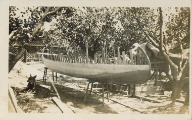
Album - Victorian Canoe Club : Album 2, 1920-30
Canoeing on the River Yarra at Melbourne was an important and widespread recreational pursuit for Melbournians, especially in the first half of the twentieth century. The Victorian Canoe Club was formed in 1912 at a meeting in Melbourne and its first committee elected in the same year. Records indicate that the Club continued into at least the 1950s .The album has historic and social significance as a record of recreational activities (as well as canoe making) in the early years of the twentieth century. It has local significance as the site of the headquarters of the Club was in Studley park. A number of photographs in the album provide vistas of Kew on the Yarra that are otherwise unavailable.24 labelled photos in part album, originating from the Victorian Canoe Club, which had its headquarters in Studley Park, Kew. The album includes a photographic record of canoe construction and also locations in Studley Park and Kew where the canoes were used. Descriptive titles in the album include (sometimes referring to two photos): Steaming gear / Mould for racer / Ribs bent on mould / Planking [3] / Planking racer / Planking Nagha / Planking completed / Off mould / Built-up ends and deck frames / Racer completed (Retriever) / Nagha & Dnapna completed / V.C.C. Studley Park / On the Yarra / Through the rapids / Yarra near Bourke [sic] Rd [2] / Camp site near Bourke [sic] Rd / Dyghts [sic] Falls, Studley Park [2] / V.C.C. site, Studley Park / Y.M.C.A. Camp, Mornington.Each photograph is labelled in white inkvictorian canoe club, canoe making, river yarra, burke road, mornington, studley park, kew -
 Kew Historical Society Inc
Photograph - Victorian Canoe Club, Off mould, 1920-30
Canoeing on the River Yarra at Melbourne was an important and widespread recreational pursuit for Melbournians, especially in the first half of the twentieth century. The Victorian Canoe Club was formed in 1912 at a meeting in Melbourne and its first committee elected in the same year. Records indicate that the Club continued into at least the 1950s .The album has historic and social significance as a record of recreational activities (as well as canoe making) in the early years of the twentieth century. It has local significance as the site of the headquarters of the Club was in Studley park. A number of photographs in the album provide vistas of Kew on the Yarra that are otherwise unavailable.One of 24 labelled photos in part album, originating from the Victorian Canoe Club, which had its headquarters in Studley Park, Kew. The album includes a photographic record of canoe construction and also locations in Studley Park and Kew where the canoes were used. The subject of this photograph is identified as 'Off mould' where, following the completion of the hull, the boat is 'righted' to allow for the finishing of the canoe.."Off mould"victorian canoe club, canoe making, river yarra, burke road, mornington, studley park, kew, steaming gear, canoe construction -
 Kew Historical Society Inc
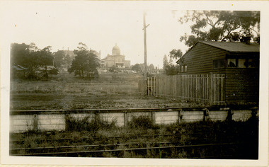
Photograph - The last train at Barker Station, 1952
The Kew railway was opened in 1887, and diverged from the main (Box Hill–Lilydale) line about half-way between Hawthorn and Glenferrie. From the point of divergence the line was slightly less than one mile long, and it had only one intermediate station — Barker. There were four road over-bridges and two level crossings, including one over the busy Barkers Road. The line supported a passenger and goods service, and was electrified in December 1922, at the same time as the main line to Box Hill. There were a number of peak hour services which ran from Flinders Street station (Melbourne) to Kew, but in 1938 all but one of these were diverted to the Ashburton line, where traffic was growing. This had an adverse effect on Kew traffic, as passengers from Kew needed to cross over a footbridge at Hawthorn to change trains, and the main line trains were usually already crowded by the time they reached Hawthorn. At about the same time the off-peak trains were replaced by road buses. In 1952 all passenger trains were withdrawn, but the road bus service continued for many years. Goods trains were finally withdrawn in 1957, and the railway was dismantled in 1958-59. (Source: Frank Stamford, 'The Hawthorn - Kew Railway')Small black and white snapshot of the last passenger train at Barker Railway Station in 1952. The photograph, one of 12, is part of a larger album of newspaper clippings, timetables, tickets and photos relating to the Kew Railway Line, taken and compiled by Lachlan Richardson, while a resident of Kew. The album dates from the 1950s. The album is part of a larger subject file on the Kew Line, compiled over time by members of the Kew Historical Society."Last train at Barker Station / 1 August 1952"kew railway line, transport -- railways -- kew (vic.), barker railway station, kew branch line -
 Kew Historical Society Inc
Photograph - Barker Station, August 1952, 1952
The Kew railway was opened in 1887, and diverged from the main (Box Hill–Lilydale) line about half-way between Hawthorn and Glenferrie. From the point of divergence the line was slightly less than one mile long, and it had only one intermediate station — Barker. There were four road over-bridges and two level crossings, including one over the busy Barkers Road. The line supported a passenger and goods service, and was electrified in December 1922, at the same time as the main line to Box Hill. There were a number of peak hour services which ran from Flinders Street station (Melbourne) to Kew, but in 1938 all but one of these were diverted to the Ashburton line, where traffic was growing. This had an adverse effect on Kew traffic, as passengers from Kew needed to cross over a footbridge at Hawthorn to change trains, and the main line trains were usually already crowded by the time they reached Hawthorn. At about the same time the off-peak trains were replaced by road buses. In 1952 all passenger trains were withdrawn, but the road bus service continued for many years. Goods trains were finally withdrawn in 1957, and the railway was dismantled in 1958-59. (Source: Frank Stamford, 'The Hawthorn - Kew Railway')Small black and white snapshot of the last passenger train at Barker Railway Station in 1952. The photograph, one of 12, is part of a larger album of newspaper clippings, timetables, tickets and photos relating to the Kew Railway Line, taken and compiled by Lachlan Richardson, while a resident of Kew. The album dates from the 1950s. The album is part of a larger subject file on the Kew Line, compiled over time by members of the Kew Historical Society."Barker Station / August 1952"kew railway line, transport -- railways -- kew (vic.), barker railway station, kew branch line -
 Kew Historical Society Inc
Photograph - Kew Railway Station: Denmark Street entrance, 1952, 1952
The Kew railway was opened in 1887, and diverged from the main (Box Hill–Lilydale) line about half-way between Hawthorn and Glenferrie. From the point of divergence the line was slightly less than one mile long, and it had only one intermediate station — Barker. There were four road over-bridges and two level crossings, including one over the busy Barkers Road. The line supported a passenger and goods service, and was electrified in December 1922, at the same time as the main line to Box Hill. There were a number of peak hour services which ran from Flinders Street station (Melbourne) to Kew, but in 1938 all but one of these were diverted to the Ashburton line, where traffic was growing. This had an adverse effect on Kew traffic, as passengers from Kew needed to cross over a footbridge at Hawthorn to change trains, and the main line trains were usually already crowded by the time they reached Hawthorn. At about the same time the off-peak trains were replaced by road buses. In 1952 all passenger trains were withdrawn, but the road bus service continued for many years. Goods trains were finally withdrawn in 1957, and the railway was dismantled in 1958-59. (Source: Frank Stamford, 'The Hawthorn - Kew Railway')Small black and white snapshot of the entrance to Kew Station from Denmark Street in 1952. The photograph, one of 12, is part of a larger album of newspaper clippings, timetables, tickets and photos relating to the Kew Railway Line, taken and compiled by Lachlan Richardson, while a resident of Kew. The album dates from the 1950s. The album is part of a larger subject file on the Kew Line, compiled over time by members of the Kew Historical Society.kew railway line, transport -- railways -- kew (vic.), kew branch line, kew railway station -
 Kew Historical Society Inc
Photograph - Kew Station 22/4/51, F3, 1952
The Kew railway was opened in 1887, and diverged from the main (Box Hill–Lilydale) line about half-way between Hawthorn and Glenferrie. From the point of divergence the line was slightly less than one mile long, and it had only one intermediate station — Barker. There were four road over-bridges and two level crossings, including one over the busy Barkers Road. The line supported a passenger and goods service, and was electrified in December 1922, at the same time as the main line to Box Hill. There were a number of peak hour services which ran from Flinders Street station (Melbourne) to Kew, but in 1938 all but one of these were diverted to the Ashburton line, where traffic was growing. This had an adverse effect on Kew traffic, as passengers from Kew needed to cross over a footbridge at Hawthorn to change trains, and the main line trains were usually already crowded by the time they reached Hawthorn. At about the same time the off-peak trains were replaced by road buses. In 1952 all passenger trains were withdrawn, but the road bus service continued for many years. Goods trains were finally withdrawn in 1957, and the railway was dismantled in 1958-59. (Source: Frank Stamford, 'The Hawthorn - Kew Railway')Small black and white snapshot of Kew Railway Station, looking south to Barker Station. The photograph, one of 12, is part of a larger album of newspaper clippings, timetables, tickets and photos relating to the Kew Railway Line, taken and compiled by Lachlan Richardson, while a resident of Kew. The album dates from the 1950s. The album is part of a larger subject file on the Kew Line, compiled over time by members of the Kew Historical Society.kew railway line, transport -- railways -- kew (vic.), kew branch line, kew railway station -
 Kew Historical Society Inc
Photograph - Kew Branch Line : The Hawthorn Grove crossing, August 1952, 1952
The Kew railway was opened in 1887, and diverged from the main (Box Hill–Lilydale) line about half-way between Hawthorn and Glenferrie. From the point of divergence the line was slightly less than one mile long, and it had only one intermediate station — Barker. There were four road over-bridges and two level crossings, including one over the busy Barkers Road. The line supported a passenger and goods service, and was electrified in December 1922, at the same time as the main line to Box Hill. There were a number of peak hour services which ran from Flinders Street station (Melbourne) to Kew, but in 1938 all but one of these were diverted to the Ashburton line, where traffic was growing. This had an adverse effect on Kew traffic, as passengers from Kew needed to cross over a footbridge at Hawthorn to change trains, and the main line trains were usually already crowded by the time they reached Hawthorn. At about the same time the off-peak trains were replaced by road buses. In 1952 all passenger trains were withdrawn, but the road bus service continued for many years. Goods trains were finally withdrawn in 1957, and the railway was dismantled in 1958-59. (Source: Frank Stamford, 'The Hawthorn - Kew Railway')Small black and white snapshot of the Hawthorn Grove crossing, August 1952. The photograph, one of 12, is part of a larger album of newspaper clippings, timetables, tickets and photos relating to the Kew Railway Line, taken and compiled by Lachlan Richardson, while a resident of Kew. The album dates from the 1950s. The album is part of a larger subject file on the Kew Line, compiled over time by members of the Kew Historical Society.kew railway line, transport -- railways -- kew (vic.), kew branch line, hawthorn grove -- hawthorn (vic.), railway crossings -
 Kew Historical Society Inc
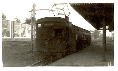
Photograph - Seven Carriage Train at Barker Station, 1952
The Kew railway was opened in 1887, and diverged from the main (Box Hill–Lilydale) line about half-way between Hawthorn and Glenferrie. From the point of divergence the line was slightly less than one mile long, and it had only one intermediate station — Barker. There were four road over-bridges and two level crossings, including one over the busy Barkers Road. The line supported a passenger and goods service, and was electrified in December 1922, at the same time as the main line to Box Hill. There were a number of peak hour services which ran from Flinders Street station (Melbourne) to Kew, but in 1938 all but one of these were diverted to the Ashburton line, where traffic was growing. This had an adverse effect on Kew traffic, as passengers from Kew needed to cross over a footbridge at Hawthorn to change trains, and the main line trains were usually already crowded by the time they reached Hawthorn. At about the same time the off-peak trains were replaced by road buses. In 1952 all passenger trains were withdrawn, but the road bus service continued for many years. Goods trains were finally withdrawn in 1957, and the railway was dismantled in 1958-59. (Source: Frank Stamford, 'The Hawthorn - Kew Railway')Small black and white snapshot of a seven carriage train approaching Barker Railway Station. The photograph, one of 12, is part of a larger album of newspaper clippings, timetables, tickets and photos relating to the Kew Railway Line, taken and compiled by Lachlan Richardson, while a resident of Kew. The album dates from the 1950s. The album is part of a larger subject file on the Kew Line, compiled over time by members of the Kew Historical Society."Seven Carriage Train at Barker Station"kew railway line, transport -- railways -- kew (vic.), barker railway station, kew branch line -
 Kew Historical Society Inc
Photograph - Farewell to 'Our Lady of Fatima'. Xavier College 22/4/51, 1952
The Kew railway was opened in 1887, and diverged from the main (Box Hill–Lilydale) line about half-way between Hawthorn and Glenferrie. From the point of divergence the line was slightly less than one mile long, and it had only one intermediate station — Barker. There were four road over-bridges and two level crossings, including one over the busy Barkers Road. The line supported a passenger and goods service, and was electrified in December 1922, at the same time as the main line to Box Hill. There were a number of peak hour services which ran from Flinders Street station (Melbourne) to Kew, but in 1938 all but one of these were diverted to the Ashburton line, where traffic was growing. This had an adverse effect on Kew traffic, as passengers from Kew needed to cross over a footbridge at Hawthorn to change trains, and the main line trains were usually already crowded by the time they reached Hawthorn. At about the same time the off-peak trains were replaced by road buses. In 1952 all passenger trains were withdrawn, but the road bus service continued for many years. Goods trains were finally withdrawn in 1957, and the railway was dismantled in 1958-59. (Source: Frank Stamford, 'The Hawthorn - Kew Railway')Small black and white snapshot of a train leaving Kew Station with the Xavier Chapel on the hill in the background, hence the ironic title provided by the photographer. The photograph, one of 12, is part of a larger album of newspaper clippings, timetables, tickets and photos relating to the Kew Railway Line, taken and compiled by Lachlan Richardson, while a resident of Kew. The album dates from the 1950s. The album is part of a larger subject file on the Kew Line, compiled over time by members of the Kew Historical Society."Farewell to 'Our Lady of Fatima'. Xavier College 22/4/51"kew railway line, transport -- railways -- kew (vic.), kew branch line, xavier college, kew railway station -
 Kew Historical Society Inc
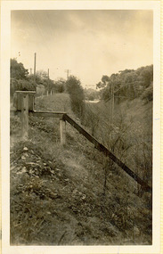
Photograph - Kew Branch Line: Looking along cutting towards Barker Station 22/4/51, 1952
The Kew railway was opened in 1887, and diverged from the main (Box Hill–Lilydale) line about half-way between Hawthorn and Glenferrie. From the point of divergence the line was slightly less than one mile long, and it had only one intermediate station — Barker. There were four road over-bridges and two level crossings, including one over the busy Barkers Road. The line supported a passenger and goods service, and was electrified in December 1922, at the same time as the main line to Box Hill. There were a number of peak hour services which ran from Flinders Street station (Melbourne) to Kew, but in 1938 all but one of these were diverted to the Ashburton line, where traffic was growing. This had an adverse effect on Kew traffic, as passengers from Kew needed to cross over a footbridge at Hawthorn to change trains, and the main line trains were usually already crowded by the time they reached Hawthorn. At about the same time the off-peak trains were replaced by road buses. In 1952 all passenger trains were withdrawn, but the road bus service continued for many years. Goods trains were finally withdrawn in 1957, and the railway was dismantled in 1958-59. (Source: Frank Stamford, 'The Hawthorn - Kew Railway')Small black and white snapshot looking along cutting towards Barker Station 22/4/51. The photograph, one of 12, is part of a larger album of newspaper clippings, timetables, tickets and photos relating to the Kew Railway Line, taken and compiled by Lachlan Richardson, while a resident of Kew. The album dates from the 1950s. The album is part of a larger subject file on the Kew Line, compiled over time by members of the Kew Historical Society."Looking along cutting towards Barker Station 22/4/51"kew railway line, transport -- railways -- kew (vic.), barker railway station, kew branch line -
 Kew Historical Society Inc
Photograph - The last train at Kew Station, August 1952
The Kew railway was opened in 1887, and diverged from the main (Box Hill–Lilydale) line about half-way between Hawthorn and Glenferrie. From the point of divergence the line was slightly less than one mile long, and it had only one intermediate station — Barker. There were four road over-bridges and two level crossings, including one over the busy Barkers Road. The line supported a passenger and goods service, and was electrified in December 1922, at the same time as the main line to Box Hill. There were a number of peak hour services which ran from Flinders Street station (Melbourne) to Kew, but in 1938 all but one of these were diverted to the Ashburton line, where traffic was growing. This had an adverse effect on Kew traffic, as passengers from Kew needed to cross over a footbridge at Hawthorn to change trains, and the main line trains were usually already crowded by the time they reached Hawthorn. At about the same time the off-peak trains were replaced by road buses. In 1952 all passenger trains were withdrawn, but the road bus service continued for many years. Goods trains were finally withdrawn in 1957, and the railway was dismantled in 1958-59. (Source: Frank Stamford, 'The Hawthorn - Kew Railway')Small black and white snapshot of the last passenger train at Kew Railway Station in 1952. The photograph, one of 12, is part of a larger album of newspaper clippings, timetables, tickets and photos relating to the Kew Railway Line, taken and compiled by Lachlan Richardson, while a resident of Kew. The album dates from the 1950s. The album is part of a larger subject file on the Kew Line, compiled over time by members of the Kew Historical Society."The last train at Kew Station, August 1952"kew railway line, transport -- railways -- kew (vic.), kew branch line, kew railway station -
 Kew Historical Society Inc
Photograph - Kew Branch Line: Weeds at Kew Station 14/51
The Kew railway was opened in 1887, and diverged from the main (Box Hill–Lilydale) line about half-way between Hawthorn and Glenferrie. From the point of divergence the line was slightly less than one mile long, and it had only one intermediate station — Barker. There were four road over-bridges and two level crossings, including one over the busy Barkers Road. The line supported a passenger and goods service, and was electrified in December 1922, at the same time as the main line to Box Hill. There were a number of peak hour services which ran from Flinders Street station (Melbourne) to Kew, but in 1938 all but one of these were diverted to the Ashburton line, where traffic was growing. This had an adverse effect on Kew traffic, as passengers from Kew needed to cross over a footbridge at Hawthorn to change trains, and the main line trains were usually already crowded by the time they reached Hawthorn. At about the same time the off-peak trains were replaced by road buses. In 1952 all passenger trains were withdrawn, but the road bus service continued for many years. Goods trains were finally withdrawn in 1957, and the railway was dismantled in 1958-59. (Source: Frank Stamford, 'The Hawthorn - Kew Railway')Small black and white snapshot of how the Kew Branch Line was allowed to run down. The photograph, one of 12, is part of a larger album of newspaper clippings, timetables, tickets and photos relating to the Kew Railway Line, taken and compiled by Lachlan Richardson, while a resident of Kew. The album dates from the 1950s. The album is part of a larger subject file on the Kew Line, compiled over time by members of the Kew Historical Society.kew railway line, transport -- railways -- kew (vic.), barker railway station, kew branch line -
 Kew Historical Society Inc
Photograph - Kew Railway Station, May 1950
The Kew railway was opened in 1887, and diverged from the main (Box Hill–Lilydale) line about half-way between Hawthorn and Glenferrie. From the point of divergence the line was slightly less than one mile long, and it had only one intermediate station — Barker. There were four road over-bridges and two level crossings, including one over the busy Barkers Road. The line supported a passenger and goods service, and was electrified in December 1922, at the same time as the main line to Box Hill. There were a number of peak hour services which ran from Flinders Street station (Melbourne) to Kew, but in 1938 all but one of these were diverted to the Ashburton line, where traffic was growing. This had an adverse effect on Kew traffic, as passengers from Kew needed to cross over a footbridge at Hawthorn to change trains, and the main line trains were usually already crowded by the time they reached Hawthorn. At about the same time the off-peak trains were replaced by road buses. In 1952 all passenger trains were withdrawn, but the road bus service continued for many years. Goods trains were finally withdrawn in 1957, and the railway was dismantled in 1958-59. (Source: Frank Stamford, 'The Hawthorn - Kew Railway')Small black and white snapshot of Kew Railway Station inMay 1950. The photograph, one of 12, is part of a larger album of newspaper clippings, timetables, tickets and photos relating to the Kew Railway Line, taken and compiled by Lachlan Richardson, while a resident of Kew. The album dates from the 1950s. The album is part of a larger subject file on the Kew Line, compiled over time by members of the Kew Historical Society."Kew Railway Station, May 1950"kew railway line, transport -- railways -- kew (vic.), kew branch line, kew railway station -
 Kew Historical Society Inc
Photograph - Kew Railway Station, 1951
The Kew railway was opened in 1887, and diverged from the main (Box Hill–Lilydale) line about half-way between Hawthorn and Glenferrie. From the point of divergence the line was slightly less than one mile long, and it had only one intermediate station — Barker. There were four road over-bridges and two level crossings, including one over the busy Barkers Road. The line supported a passenger and goods service, and was electrified in December 1922, at the same time as the main line to Box Hill. There were a number of peak hour services which ran from Flinders Street station (Melbourne) to Kew, but in 1938 all but one of these were diverted to the Ashburton line, where traffic was growing. This had an adverse effect on Kew traffic, as passengers from Kew needed to cross over a footbridge at Hawthorn to change trains, and the main line trains were usually already crowded by the time they reached Hawthorn. At about the same time the off-peak trains were replaced by road buses. In 1952 all passenger trains were withdrawn, but the road bus service continued for many years. Goods trains were finally withdrawn in 1957, and the railway was dismantled in 1958-59. (Source: Frank Stamford, 'The Hawthorn - Kew Railway')Small black and white snapshot of Kew Railway Station in 1950. The photograph, one of 12, is part of a larger album of newspaper clippings, timetables, tickets and photos relating to the Kew Railway Line, taken and compiled by Lachlan Richardson, while a resident of Kew. The album dates from the 1950s. The album is part of a larger subject file on the Kew Line, compiled over time by members of the Kew Historical Society."Kew Station / 14/51 / 22/4/51 F5"kew railway line, transport -- railways -- kew (vic.), kew branch line, kew railway station -
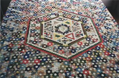 Kew Historical Society Inc
Decorative object - Large mid-Victorian silk patchwork quilt, 1850-1860
A silk patchwork quilt in a hexagons pattern originally owned by the Denbigh family of ‘Wimba’. The Denbigh family is recorded as living at ‘Park Villa’ ‘near Kew’ in 1856. John Denbigh was at this stage the superintendent of the local Baptist school. By 1869 they are listed as residing in Cotham Road. John Sharp Denbigh’s death in 1875 resulted in the sale of Wimba. This is an important early English silk hexagons quilt with outstanding technical workmanship, and is well-provenanced.The quilt is constructed in the popular hexagon pattern of silk off-cuts of an earlier period. Hexagon patchwork quilts were typically constructed of individual hexagons, which were formed using paper or card templates. Where these are visible, it would indicate that writing paper was used to form the templates. The quilt is unlined and has a green silk border, added at a later date. Early 19th Century patchwork quilts tended to use cotton to create the hexagons, whereas silk became the preferred medium mid-century. The quilt has been dated to the middle decades of the 19th century due to the colour range, and the exclusion of black silk hexagons. Most of the silk used in the quilt has a sheen, however there is some use of velvet in one or two larger hexagons. The exposed reverse of the quilt includes a large amount of very fine hand stitching.An unlined quilt was typically used as a summer spread. patchwork quilt, hexagon pattern, denbigh family, wimba, cotham road, kew, john denbigh, helen johnston, quilt, patchwork, textiles, migration to australia -
 Kew Historical Society Inc
Plan - Subdivision Plan, Birdwood Estate, 1920
Pru Sanderson, in her groundbreaking ‘City of Kew Urban Conservation Study : Volume 2 - Development History’ (1988), summarised the periods of urban development and subdivisions of land in Kew. The periods that she identified included 1845-1880, 1880-1893, 1893-1921, 1921-1933, 1933-1943, and Post-War Development. These periods were selected as they represented periods of rapid growth or decline in urban development. An obvious starting point for Sanderson’s groupings involved population growth and the associated economic cycles. These cycles also highlighted urban expansion onto land that was predominantly rural, although in other cases it represented the decline and breakup of large estates. A number of the plans in the Kew Historical Society’s collection can also be found in other collections, such as those of the State Library of Victoria and the Boroondara Library Service. A number are however unique to the collection.The Kew Historical Society collection includes almost 100 subdivision plans pertaining to suburbs of the City of Melbourne. Most of these are of Kew, Kew East or Studley Park, although a smaller number are plans of Camberwell, Deepdene, Balwyn and Hawthorn. It is believed that the majority of the plans were gifted to the Society by persons connected with the real estate firm - J. R. Mathers and McMillan, 136 Cotham Road, Kew. The Plans in the collection are rarely in pristine form, being working plans on which the agent would write notes and record lots sold and the prices of these. The subdivision plans are historically significant examples of the growth of urban Melbourne from the beginning of the 20th Century up until the 1980s. A number of the plans are double-sided and often include a photograph on the reverse. A number of the latter are by noted photographers such as J.E. Barnes.Bordering Burke Road, the Birdwood Estate included a subdivision of 34 lots on either side of Birdwood Street, Balwyn. Six of the lots faced Burke Road. At the other end of the subdivision a line would indicate that a creek once bordered the subdivision. Lots were advertised for sale at a low figure on five-year terms. Purchasers could pay off the balance in twenty quarterly instalments (i.e. over five years).subdivision plans - balwyn, birdwood estate -
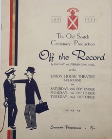 Kew Historical Society Inc
Programme - Theatre Programme, Off the Record / by Ian Hay and Stephen King-Hall, 1951
The Old Scotch Collegians' Dramatic Society was formed in 1933. This performance celebrated the 100th anniversary of the College in 1951.Arthur Henry Dear was an employee of the City of Kew, acting as Hall Keeper of the Kew Recreation Hall in Wellington Street, and later the new Kew City Hall in Cotham Road. The Arthur Dear Collection contains memorabilia - tickets, programmes, invitations - as well as his identification badge. Items in the collection dates from the 1940s to the 1960s. Programme for the Old Scotch Centenary production of Off the Record by Ian Hay and Stephen King-Hall, performed in 1951 at the Union Theatre, Melbourne. The programme contains a history of the Old Scotch Collegians Dramatic Society (founded in 1933), a cast list, synopsis and cast profiles. 12 pp.old scotch collegians' dramatic society, union theatre - university of melbourne, arthur dear collection, theatre memorabilia -
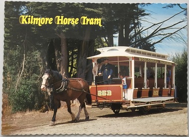 Kew Historical Society Inc
Postcard, The Tramway Museum Society of Victoria Ltd, Kilmore Horse Tram, c.1991
The Kew Historical Society's postcard collection includes views of Kew, Melbourne and Greater Melbourne as well as those including overseas scenes sent or received from Europe or the Middle East. They date from the 1890s to the 2000s.Modern postcard produced by the Tramway Museum Society of Victoria. The photo is of a replica tram in Victoria's Tramway Museum, and was presumably purchased for display purposes for an exhibition relating to transport in Kew, and in particular to the Kew horse-tram which operated from the Victoria Street Bridge to the Boroondara General Cemetery in Kew.This replica tram, constructed by members Alan Antcliff and Newton Williams in Mildura represents the open car used between Sydney Road and the Royal Melbourne Zoological Gradens until 1923. The open "toast rack" type was use extensively on other horse and early electric tram systems. Photo by William F Scott. Produced by The Tramway Museum of Victoria Ltd Box 4916, Mail Exchange, Melbourne, Victoria, 3001. Operator of Victoria's Tramway Museum, Union Lane, Bylands (55 km from Melbourne off the Northern Highway) Open Sundays 11a.m - 5p.m. CS2036kilmore horse tram, tramway museum society of victoria, tramways - victoria, postcards -
 Kew Historical Society Inc
Postcard, The Tramway Museum Society of Victoria Ltd, Kilmore Horse Tram, c.1991
The Kew Historical Society's postcard collection includes views of Kew, Melbourne and Greater Melbourne as well as those including overseas scenes sent or received from Europe or the Middle East. They date from the 1890s to the 2000s.Modern postcard produced by the Tramway Museum Society of Victoria. The photo is of a replica tram in Victoria's Tramway Museum, and was presumably purchased for display purposes for an exhibition relating to transport in Kew, and in particular to the Kew horse-tram which operated from the Victoria Street Bridge to the Boroondara General Cemetery in Kew.This replica tram, constructed by members Alan Antcliff and Newton Williams in Mildura represents the open car used between Sydney Road and the Royal Melbourne Zoological Gradens until 1923. The open "toast rack" type was use extensively on other horse and early electric tram systems. Photo by William F Scott. Produced by The Tramway Museum of Victoria Ltd Box 4916, Mail Exchange, Melbourne, Victoria, 3001. Operator of Victoria's Tramway Museum, Union Lane, Bylands (55 km from Melbourne off the Northern Highway) Open Sundays 11a.m - 5p.m. CS2036 kilmore horse tram, tramway museum society of victoria, tramways - victoria, postcards -
 Kew Historical Society Inc
Plan, Melbourne & Metropolitan Board of Works : Borough of Kew : Detail Plan No.1571, 1904
The Melbourne and Metropolitan Board of Works (MMBW) plans were produced from the 1890s to the 1950s. They were crucial to the design and development of Melbourne's sewerage and drainage system. The plans, at a scale of 40 feet to 1 inch (1:480), provide a detailed historical record of Melbourne streetscapes and environmental features. Each plan covers one or two street blocks (roughly six streets), showing details of buildings, including garden layouts and ownership boundaries, and features such as laneways, drains, bridges, parks, municipal boundaries and other prominent landmarks as they existed at the time each plan was produced. (Source: State Library of Victoria)This plan forms part of a large group of MMBW plans and maps that was donated to the Society by the Mr Poulter, City Engineer of the City of Kew in 1989. Within this collection, thirty-five hand-coloured plans, backed with linen, are of statewide significance as they include annotations that provide details of construction materials used in buildings in the first decade of the 20th century as well as additional information about land ownership and usage. The copies in the Public Record Office Victoria and the State Library of Victoria are monochrome versions which do not denote building materials so that the maps in this collection are invaluable and unique tools for researchers and heritage consultants. A number of the plans are not held in the collection of the State Library of Victoria so they have the additional attribute of rarity.Digital copy of the original survey plan, issued by the MMBW to a contractor with responsibility for constructing sewers in the area identified on the plan within the Borough of Kew. The plan was at some stage hand-coloured, possibly by the contractor, but more likely by officers working in the Engineering Department of the Borough and later Town, then City of Kew. The hand-coloured sections of buildings on the plan were used to denote masonry or brick constructions (pink), weatherboard constructions (yellow), and public buildings (grey). This plan is part of a large and historically significant group of MMBW plans and maps that was donated to the Society by the Mr Poulter, City Engineer of the City of Kew in 1989. When the contracts were let for surveyors to identify and record the extant houses and landscapes within an area for the Board of Works, the contracts were let at separate times, hence the anomaly where two copies of Plan No.1571 exist in our collection. The first of these plans identifies the building materials used in houses bordering Fitzwilliam Street, Edgevale Road, May Street, Malin Street, Davis Street and Wellington Street. The cut off point for the survey was the south side of Wellington Street. By 1903 when the survey was undertaken many of the sites were already built on, particularly those facing Edgevale Road. The plan identifies the preponderance of weatherboard houses in the area. The other version of the plan identifies the buildings between Wellington Street and Cotham Road.melbourne and metropolitan board of works, detail plans, mmbw 1571, cartography