Showing 2440 items matching "orchard"
-
 University of Melbourne, Burnley Campus Archives
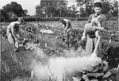
Photograph - Black and white print, Publicity Branch, Department of Agriculture, Victoria, Students Working in the Vegetable Plots, c. 1962
Note by T.H. Kneen 18 December 1991 "Students L-R: Lex Hodge (1962),Oliver Frost (1962), Peter Trudgeon (1963). The location of the photo is the student individual plot ground."2 copies black and white photograph. Students dusting, watering and digging in their vegetable plots.On reverse stamp, "Photograph by Publicity Branch Victorian Department Of Agriculture Ref. No. c.1695N."watering, digging, lex hodge, oliver frost, peter trudgeon, department of agriculture, students, dusting vegetables, vegetable plots, students working outside, orchard -
 University of Melbourne, Burnley Campus Archives
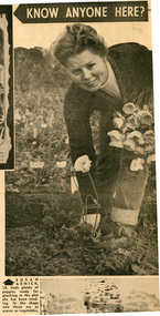
Newspaper - Newspaper Cutting, The Sun, Fewer Girls There Now, 1963
Compares the College of today with the College 29 years ago especially in relation to the proportion of female students.2 copies of Article in "The Sun" July 26, 1963 p22. (1) "Susan Axnick, 18, finds plenty of poppies ready for the picking in the plot she has been tending. In the shops now these are as scarce as vegetables." (2) "Tractors have come these days even to the small plots of the horticulturalist. Here Lawrice Inglis, 17, (1966) drives while Paul Bucknell (1966), 16, left, and Rod Dawson (1966), 17, stand with their shovels ready." (3) "Cathy Taylor (1965), 18, a second year prefect at the school, holds up two cauliflowers of a size that would be hard to buy anywhere today. She grew them herself."lawrice inglis, paul bucknell, rod dawson, cathy taylor, susan axnick, poppies, students working outside, tractor, prefect, cauliflower, orchard -
 Eltham District Historical Society Inc
Photograph - Aerial Photograph, Landata, Eltham, Vic, Apr. 1972
Centred on present day Woodridge Estate, Eltham bounded by Park Road to north, Mount Pleasant Road to south, Stokes Orchard Estate to east and Eltham Railway Station to west. Historic Aerial Imagery Source: Landata.vic.gov.au Aerial Photo Details: Project No :985 Project : MELBOURNE 1972 Run : 27 Frame : 46 Date : 04/1972 Film Type : B/W Camera : RC10 Flying Height : 5700 Scale : 9600 Film Number : 2636 GDA2020 : 37°42'49"S, 145°09'46"E MGA2020 : 338053, 5824365 (55) Melways : 22 C5 (ed. 42)aerial photo, neil webster collection, 1972-04, eltham, eltham railway station, melway 22c5, mount pleasant road, park road, stokes orchard estate, woodridge estate -
 Greensborough Historical Society
Photograph - Photograph - Digital image, Pill Family, 1910c
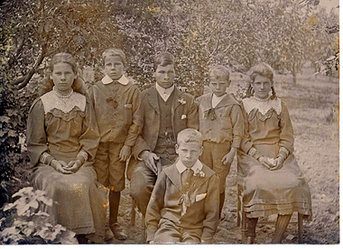
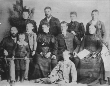
Part of a collection of photographs copied from the late Shirley Fraser (nee Black), also descendant of the McLaughlin and Whatmough family. This photograph shows six children of the Pill family (mother Jessie Ann Whatmough, father John Henry Pill), taken at family orchard at 1440 Heidelberg - Kinglake Rd Cottlesbridge. The children are from left to right; Evelyn Alice b 1890, Bertram b 1896, Edwin Henry b 1888, Harry Stanley b 1899, Florence Jessie b 1892 and seated in front William John b 1894. William John Pill was murdered at Cottlesbridge in 1958. local familyDigital copy of black and white photograph.shirley fraser, pill family -
 Greensborough Historical Society
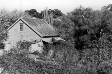
Photograph - Digital Image, Willis Vale, 1950c
Willis Vale: House built by Edward Maygar, Robert Whatmough lived there mid 19th century and later sold to Partington family. It was located on the Plenty River at Partington's Flat Greensborough. Land use included farming and orchards. The derelict Willis Vale house was vandalized in 1964 and destroyed when a fire originating from North Plenty Gorge - Kurrak Road - was lit by two teenage boys and made its way several kilometres down to Partington's Flat Greensborough. This photo was taken after the Partington's moved house in 1947 across the river where Alan built their new Alwyn house that had access to electricity.Home of the Partington familyDigital copy of black and white photograph.willis vale, partington family, whatmough, maygar family -
 Greensborough Historical Society
Photograph - Digital Image, Willis Vale, 1950c
Willis Vale: House built by Edward Maygar, Robert Whatmough lived there mid 19th century and later sold to Partington family. It was located on the Plenty River at Partington's Flat Greensborough. Land use included farming and orchards. The derelict Willis Vale house was vandalized in 1964 and destroyed when a fire originating from North Plenty Gorge - Kurrak Road - was lit by two teenage boys and made its way several kilometres down to Partington's Flat Greensborough. This photo was taken after the Partington's moved house in 1947; across the river where Alan built their new Alwyn house that had access to electricity.Home of the Partington familyDigital copy of black and white photograph.willis vale, partington, whatmough, maygar -
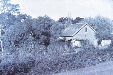
 Eltham District Historical Society Inc
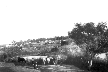
Negative - Photograph, Bridge Street, Eltham, c.1910
View from Maria Street (Main Road) along Bridge Street, Eltham, looking towards Montmorency. The house on the right at the corner of Susan and Bridge streets was owned for many years by the Hill family until Council bought it in the early 1960s. The house was built in the 1850s or 60s. The house on the left stood on what is now the southwest corner of Susan and Bridge Streets. The Braithwaite family was associated with this house. Orchards in the foreground either side of the Diamond Creek. The line of trees running up the hill to the left represents the Bolton street alignment. Based on hand writing of title on image compared with others, date is estimated at c.1910.This photo forms part of a collection of photographs gathered by the Shire of Eltham for their centenary project book,"Pioneers and Painters: 100 years of the Shire of Eltham" by Alan Marshall (1971). The collection of over 500 images is held in partnership between Eltham District Historical Society and Yarra Plenty Regional Library (Eltham Library) and is now formally known as the 'The Shire of Eltham Pioneers Photograph Collection.' It is significant in being the first community sourced collection representing the places and people of the Shire's first one hundred years.Digital image 4 x 5 inch B&W Negshire of eltham pioneers photograph collection, bolton steet, braithwaite, bridge, bridge street, bridge street bridge, eltham, hill family home, susan street, orchards -
 Federation University Historical Collection
Photograph - Photograph and Documents, Anne Beggs Sunter, Latta/Downing Family, Mount Helen
The Federation University Mt Helen Campus was once the farm of John Latta and his wife Elizabeth Ann Dean. The couple married in 1867 and had three children at the time of John Latta's death (Elizabeth Ann b.1870; Mary b.1873; John b.1875). Elizabeth later married George Downing, and had another six children. The house was situated in the vicinity of the current Administration and Caro Conference Centre buildings, surrounded by an orchard, and a well under the current Albert Coates Building (Union Building). The land was purchased by the Ballarat School of Mines for their tertiary division from the Stapleton family.Various items relating to the Federation University Mount Helen Campus, and the early settlers on the land, the Latta Family. .1) Parish Plan, including E. Latta, M. Fiscalini, R. Wynne, R. Nixon, J.U. Smith, J. Davis .2) Part of a 1930s ordinance map showing Ballarat, Buninyong and Greenhill .3) Contour Map with the first two Mt Helen Campus buildings included. .4) Drawing a a proposed campus plan .5) Latta Family negativemount helen campus, latta family, greenhill, e. latta, m. fiscalini, r. wynne, r. nixon, j.u. smith, j. davis, parish plan, john latta, elizabeth latta, george downing, elezabeth downing, green hill, pontresina, abraham baxter, g. dean, market gardens, jim downing, bob thornton, j. hateley, martin fanning, toll keeper, anne beggs sunter -
 Whitehorse Historical Society Inc.
Photograph, Luke Group, 1959
K.G. Luke had a foundry in Queen's Parade, Melbourne which made badges and manufactured items for the Armed Forces during the First World War. He bought 40 acres of cherry orchard in Mitcham in 1952 from a Miss Cook, then went to England and attracted finance from Singer Brass Founders. The company became Luke and Singer. The three factories on site were Luke Manufacturing - stainless steel products and hospital equipment, Luke and Singer - a non-ferrous foundry producing components for industry such as nuts and cutlery, and Concentric Engineering - machinery components. Later the manufacture of refrigeration and air conditioning was added at the rear of the complex. A small aerial photograph and 2 A4 photocopies of the K.G.Luke Group of companies in 1959. The factory site is divided into three groups with Whitehorse Road situated at the bottom of the photo and Cook Road Mitcham to the left. Notes at ND6245luke manufacturing, k.g.luke group, luke and singer, concentric engineering, wheatland, vic, manufacturing industry, foundries, engineering industries -
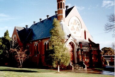 Surrey Hills Historical Society Collection
Photograph, St Stephen's Presbyterian Church, Surrey Hills, viewed from Warrigal Road, 1980's
The first service of the Surrey Hills Presbyterian Church was held at ‘Kinnoul’, the home of Thomas Hogg, located in The Avenue. This was while the church was being built. St Stephens Presbyterian Church opened in March 1899 on land that had previously been part of Klepper's orchard. The first minister was Rev F A Darling. He resigned in 1892 to open Surrey College. The church building pictured was built in 1910 adjacent on land gifted to the church. Noted features of the interior are the pulpit and honor board carved by sculptor John Kendrick Blogg. There are also memorial windows to Charles de Burgh Hogg and William Thomas Hogg, both killed in WW1.Red brick church with bell tower and slate roof. Cyprus tree at side; other trees fronting Canterbury Road.Canterbury Road - Warrigal Rd (written in biro on th back of photo)stained glass, lead lights, churches, presbyterian church, st stephens presbyterian church, 1980-1989, surrey hills, canterbury road, warrigal road, john kendrick blogg, charles de burgh hogg, thomas william hogg -
 Ringwood and District Historical Society
Article - Newspaper Clipping, Land Sale Advertisements, Golden Hill Estate, Ringwood - 1965, 1966, and Plan of Survey of Lot 8, Mullum Mullum Road Ringwood, 1970
Newspaper clippings from Melbourne Sun newspaper (11th December 1965 and 15th January 1966) advertising sale of land - Golden Hill Estate, Ringwood, with summary of features and aerial photograph including artistic representation of street layout. Subdivision includes Mullum Mullum Road, Sonia Street, Jill Court, Linda Drive, Eve Court, Alma Court, and Jacynthe Court. Attachments include reference to Lot 46 as site of original Peter Vergers' orchard residence and subsequent 1970 surveyor's Plan of Survey of Lot 8 Mullum Mullum Road Ringwood, LP 67513, Cert of Title 8581/429.Agent - Aaron, King & Co., Suite 2, 33 Queens Road, Melbourne. (Phone) 26-2443, A.H. 850-2195. Plan of Survey signed on 25.7.1970 by Roger M. Gamble, Land Surveyor, 28 Summit Crescent, Ringwood 3134. -
 Bendigo Historical Society Inc.
Document - SEDGWICK INFORMATION
Document, Sedgwick, was known as Upper Emu Creek until 1901. It is located ten miles south of Bendigo in hilly sedimentary and granite country.The first freehold grants were taken up in 1854. In 1861 the Strathfieldsaye Road District was Proclaimed. Five years later it became the Shire of Strayhfieldsaye.Mining west of the Axe Creek commenced in 1863. Agriculture, farmers made modest livings from vineyards, orchards,dairy cattle, eggs and tomatoes. The Osborne family had seventy acres planted to apples. Prior to 1934 Favaloros collected cream from district farms, then fresh milk in cans was carted to Bendigo until 1970.document, sedgwick -
 University of Melbourne, Burnley Campus Archives
Album - 35mm Colour slides, Miscellaneous, 1967
1. "Drive (After) from P.R.I" Feb 67. 2-5. Students learning how to use a machine in the Orchard, 6, 7.Former Nursery, 8. Garden view. Mar 67. 9-14. Emily Gibson beds. Jun 67. 15, 19,26, 27. Plant Research Institute. "June.5.1967" 16, 17. Pruning Day 1`967. 18.Unidentified development on Campus Jul 67. 20. "Nangiloc - Fixed Sprinkler Rock Melons" Oct 67. 22. Yarra River.24. Former Rose garden (now Herbaceous Border.) 28-35 Wilson's Promontory.students, machine, garden views, campus, entrance, plant research institute, old rose garden, nursery, nangiloc, fixed sprinkler, rock melons, wilson's promontory, seed testing station, pruning day, emily gibson beds -
 Ringwood and District Historical Society
Photograph, Maroondah Highway Central, Ringwood. Warrandyte Rd looking North from Main Street, Ringwood. 1908
Black and white photograph reproduced from post card. Scene of road looking towards Loughnan Hill, Andrew Kennedy's orchard. Horse and cart in centre of photo, orchard to left of picture. (3 enlarged copies, 2 postcards, a clipping and 1 9x18.5 reproduction) Postcards with correspondence from N Blood, 2 original of the postcards with messages. First reads: "Trust you are well my dear and hope your poor Mater is no worse but better. We arrived home safely..poor little Tim was very tired. Love from all to your sister and mother..self. Your sincere friend, N. Blood" Second Reads: "Miss Hill. Cowes P.O.. 4/3/09 Dear Olive, come at once; I am on my last legs! Very pleased to hear that you have been enjoying yourself as well. Your mother had been very ill and Elvie has lost a stone weight; and ??? looks down in the dumps. Topsy killed canary this morning so I took Topsy for a walk! Had a bush fire up at home on 22 and 23rd Feb. No time to scribble more. Yours to a cinder. Bert." This postcard writing is overstamped J.B.McAlpin, Estate and Financial Agent. District Government Valuer Ringwood. It has a 1d Victorian Stamp affixed. Typed below photograph, "Warrandyte Rd. from Maroondah Hwy. looking north. Mullum Creek bridge in dip - 1908". -
![Photograph - Digital image, Willis Vale [side view], 1950c](/media/collectors/4f729f5697f83e03086015b8/items/5502a2592162f11024c32328/item-media/5502a2852162f11024c3268d/item-fit-380x285.jpg) Greensborough Historical Society
Greensborough Historical SocietyPhotograph - Digital image, Willis Vale [side view], 1950c
Willis Vale: House built by Edward Maygar, Robert Whatmough lived there mid 19th century and later sold to Partington family. It was located on the Plenty River at Partington's Flat Greensborough. Land use included farming and orchards. The derelict Willis Vale house was vandalized in 1964 and destroyed when a fire originating from North Plenty Gorge - Kurrak Road - was lit by two teenage boys and made its way several kilometres down to Partington's Flat Greensborough. This photo was taken after the Partington's moved house in 1947. across the river where Alan built their new Alwyn house that had access to electricity. Home of the Partington family Home of the Partington familyDigital copy of black and white photograph.willis vale, partington, whatmough, maygar -
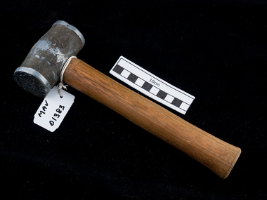 City of Moorabbin Historical Society (Operating the Box Cottage Museum)
Tool - Hammer small sledge, c1900, c1900
A hammer is a tool consisting of a weighted "head" fixed to a long handle that is swung to deliver an impact to a small area of an object. This is a small sledgehammer whose relatively light weight and short handle allow single-handed use. It is useful for light demolition work, driving masonry nails, and for use with a steel chisel when cutting stone or metal. Among the early settlers in Moorabbin Shire were blacksmiths who made tools for the other settlers who were establishing the homes, market gardens, farms, orchards and various businesses. Early settlers were self reliant and repaired their own equipment for kitchen,dairy, farm, horses, carts using various tools . This hammer is typical of the type used by early settlers in Moorabbin Shire c1900This is a small sledge hammer with a wood handle and double sided round metal headearly settlers, market gardeners, blacksmiths, tools, building equipment, hammers, moorabbin shire, bentleigh, mckinnon, highett, cheltenham,mcewan james pty ltd, melbourne, bunnings pty ltd, -
 Melbourne Tram Museum
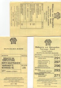
Ephemera - Timetable/s, Melbourne & Metropolitan Tramways Board (MMTB), "MMTB Bus Timetables", 1981 - 1984
Timetables for specific routes, day of week giving information on tram times at specific time points, route map, sections and fares and organisation address - 616 Little Collins St. Melbourne. All printed on yellow paper. .1 - Timetable for Box Hill via Shoppingtown and Templestowe, Doncaster bus services, dated July 1981 - routes 291, 297, 296, 293 and 271. .2 - Services via Templestowe, North Balwyn and Kew, Warrandyte and Newmans Rd - routes 276, 278 and 279 - July 1982 .3 - Services via East Doncaster, North Balwyn, Kew, Warrandyte, City, Shoppingtown - routes 277, 280, 281 and 268 - dated Jan. 1983 .4 - ditto as above, including Park Orchards and Donvale - routes 265, 262, 261, 260, 266 and 264 - dated Feb. 1983 .5 - North Altona - City Route 232 - April 1984 - issued by Metropolitan Transit with their logo. 6 - Garden City, Port Melbourne - City - Sept 1982 - routes 201, 202 7 - Sunshine - Footscray - City - Routes 230 and 231 - Jan. 1982 8 - North Altona - City - MMTB logo, route 232 - Nov. 1982 9 - East Kew, Box Hill, Doncaster - Express bus - Box Hill to City - routes 284, 270, 300 - April 1982 10 - Ringwood - Warrandyte, Park Orchards, Mitcham - routes 313, 31, 315 and 316 - Jan. 1983Yields information about MMTB Bus services early 1980s and 1 The Met badged item.Set of 9 MMTB and 1 MTA Bus timetables, folded sheets, 8 sections.trams, tramways, mmtb, timetables, melbourne, fares, east kew, box hill, doncaster, north altona, route 232, route 201, route 202, route 220, route 231, route 284, route 270, route 300, route 313, route 314, route 315, route 316 -
 Whitehorse Historical Society Inc.
Article, New tennis courts for East Burwood, 1966
A public meeting to form a new tennis club for East Burwood attracted 90 tennis players from both Waverley and Nunawading.A public meeting to form a new tennis club for East Burwood attracted 90 tennis players from both Waverley and Nunawading. These included Harry Hopman and the Mayor of Nunawading, Cr Terry. Office bearers were elected.A public meeting to form a new tennis club for East Burwood attracted 90 tennis players from both Waverley and Nunawading.tennis, east burwood tennis club, westaway, p, orchard, j, wiseman, a., cockerell, l (mrs), tainton, m. (mrs) -
 Ringwood and District Historical Society
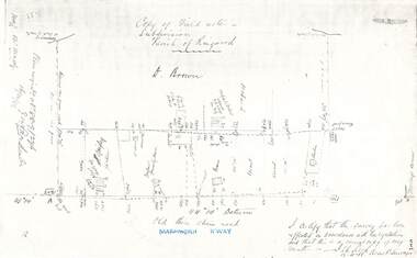
Document - Copy of Lands Department Field Notes - Parish of Ringwood, Victoria, Field Notes 88-9/276 - Part of O.P. R72C surveyed 12.10.1888
Foolscap size photocopy of survey map with handwritten notations. References include - Commencing at bank of creek, Bearing over fence read 134"12', post and rail fence, old round post, Quigley, WB house iron roof, paling & shingle roof, garden, Forshaw formerly Hoare, D Brown, stable & shed, slats & palings, orchard, Occupied by Forshaw, 4 rooms WB Cottage iron roof, Sherbin, Old three chain road, Maroondah Highway, Molloy's corner, I certify that this survey has been effected in accordance with the regulations and that this is a correct copy of my results (signed) - Reed, Assistant Surveyor, 12.10.88. -
Whitehorse Historical Society Inc.
Newspaper - Article, Old spacious home key to past Mitcham, 24/01/1968
Article in Nunawading Gazette about 'Windouran', a spacious home unchanged since its picture was used to boost Mitcham's first subdivision sale. It has been divided into 2 flats but still looks stately. In 1915 70 big home sites were sold in an area bounded by Mitcham Road, Halls Parade, Orient Avenue and Vernal Avenue. The estate was known locally as 'Mother Foster's Estate'. Mr James Thatcher brought the brochure to the Gazette - his grandfather, Joseph Lloyd bought land at that sale. David Lloyd (Thatcher's uncle) lived there. James Thatcher had an orchard at that time on a hill above Centre Road, Vermont.houses, windouran, windouran drive, mitcham, mitcham, thatcher, james, mitcham road, mitcham, halls parade, mitcham, orient avenue, mitcham, vernal avenue, mitcham, mother foster's estate, lloyd, joseph, lloyd, david, simon, kingsley -
 Whitehorse Historical Society Inc.
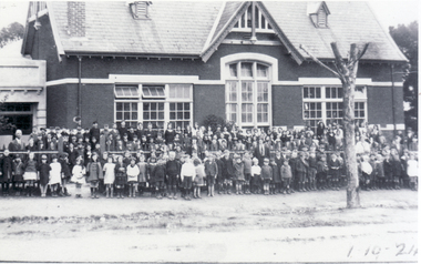
Photograph, Pupils Outside Mitcham State School, 1/10/1924 12:00:00 AM
Information - J.Bamford: 'In the late 1930's and 40's there were two parts of the Mitcham State School. The Bubs and grades 1 to 3 were in a building on Mitcham Road that was near the laneway behind the shops,and grades 4 to 8 were further down Mitcham Road. There were several houses on Mitcham Road to the left of this photograph, with parkland behind.. The left rear of the school also joined the park. The right side of the school joined Sampson's orchard, which went down as far as Springfield Road. This road was then called the Stock Route because that was what it was back then.' By the number of children present, it appears that both sections of the school got together for this 1924 photograph.field, jean., mitcham state school, no. 2904, mitcham road, mitcham, victoria street mitcham -
University of Melbourne, Burnley Campus Archives
Newspaper, The Australasian, Burnley (V.) School of Horticulture, 1934
(A) Illustrations in a Newspaper Article in, "The Australasian," June 2, 1934 p vii. Also (B) a photocopy. (1) "Main entrance from Swan street, Burnley." (but possibly taken C.1927.)(2) "Mr. G. Russ, head demonstrator in horticulture." (3) "Science and research laboratory." (4) "Mr. C. French, Government biologist, in front of the glasshouse used for experimental work."(Plant Science laboratory) (5) Students in the vegetable garden."(Paynter? and W. Thompson) (6) "The principal, Mr. A.W. Jessep, B.Agr.Sci., staff, and students." Some named in paper catalogue. (7) "Special house erected to investigate tomato wilt disease." (8) "Students at work in the orchard."the australasian, george russ, head demonstrator, laboratory, c. french, government biologist, glasshouse, plant science laboratory, students, vegetable gardens, w. thompson, principal, a.w. jessep, staff -
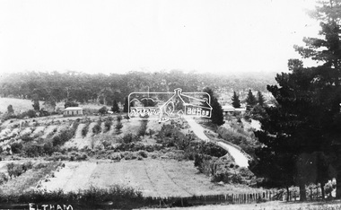
 Eltham District Historical Society Inc
Photograph - Aerial Photograph, Landata, Eltham, Feb. 1956
Centred on present day Culla Hill and Petty's Orchard, Eltham bounded by Brougham Street and Mount Pleasant Road to north, Monckton Road, Templestowe to south, Reynolds Road to east and Eltham Lower Park and Hohnes Road to west. Historic Aerial Imagery Source: Landata.vic.gov.au Aerial Photo Details: Project No :250 Project : MELBOURNE OUTER SUBURBS PROJECT Run : 18 Frame : 92 Date : 02/1956 Film Type : B/W Camera : EAG9 Flying Height : 10000 Scale : 12000 Film Number : 1176 GDA2020 : 37°43'35"S, 145°09'31"E MGA2020 : 337735, 5822959 (55) Melways : 22 B8 (ed. 42)aerial photo, 1956-02, neil webster collection, eltham, brougham steet, culla hill, eltham lower park, hohnes road, melway 22b8, monckton road, mount pleasant road, petty's orchard, reynolds road, sweeneys lane, templestowe, yarra river -
 Greensborough Historical Society
Photograph - Digital Image, View of Greensborough from Willis Vale, 1906_
View of Greensborough from Willis Vale. The people in the photograph were visitors and not identified. Willis Vale: House built by Edward Maygar, Robert Whatmough lived there mid 19th century and later sold to Partington family. It was located on the Plenty River at Partington's Flat Greensborough. Land use included farming and orchards. The derelict Willis Vale house was destroyed in 1964 when a fire originating from North Plenty Gorge - Kurrak Road - was lit by two teenage boys and made its way several kilometres down to Partington's Flat Greensborough. [Ellen died on 13/10/1903 - Some think this photo is thought to have been taken shortly after, at her funeral.]Digital copy of black and white photograph.willis vale, greensborough, partington family -
 Greensborough Historical Society
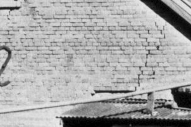
Photograph - Digital Image, Brickwork, Willis Vale, 1950c
Close up photograph of a section of brickwork at Willis Vale. This is the end wall under the roof. Willis Vale built by Edward Maygar, Robert Whatmough lived there mid 19th century and later sold to Partington family. It was located on the Plenty River at Partington's Flat Greensborough. Land use included farming and orchards. The derelict Willis Vale house was vandalized in 1964 and destroyed when a fire originating from North Plenty Gorge - Kurrak Road - was lit by two teenage boys and made its way several kilometres down to Partington's Flat Greensborough. This photo was taken after the Partington's moved house in 1947 across the river where Alan built their new Alwyn house that had access to electricity.Part of Willis Vale, a pioneer home in the Greensborough area.Digital copy of black and white photograph.willis vale -
 Eltham District Historical Society Inc
Journal - Newsletter, Newsletter, No. 275 April 2024
Contents: • The Value of History by Jim Connor • Next Meeting – Annual General Meeting - 2.00pm Saturday 13th April 2024 • May Excursion - Saturday 4th May – Stokes Orchard and beyond • Tourism to Eltham in the Early Days by Michael Aitken • Main Road Bridge by Peter Pidgeon • Where is Platy? By Jim Connor • Montsalvat People by Richard Pinn o Helen Skipper (1914-2000) o John Busst (1909-1971) • Harris – A Name for Three Wars by Terry Beaton • Notice: Annual General Meeting – Saturday 13th April 2024 • Eltham Cemetery Stories by Liz Pidgeon o Grace Mitchell, nee Wheildon, 1916-2011, Baker and Artist • Bendigo Bank, Community Bank The Shire of Eltham Historical Society was formed in October 1967. The first newsletter of the Society was issued May 1978 and has been published continuously ever since on a bi-monthly basis. With the cessation of the Shire of Eltham in late 1994, the Society's name was revised to Eltham District Historical Society and this name first appeared with issue No. 103, July 1995. The collection of the Society's newsletters provides a valuable resource on the history of the Society's activities, office bearers and committee members, guest speakers and subjects of historical interest pertinent to the former Shire of Eltham and the Eltham District.A4 newsletter distributed to members (Digital and A4 photocopy)newsletter, eltham district historical society -
 Whitehorse Historical Society Inc.
Book, Glenburnie among the trees, 1997
History of Glenburnie Road, VermontHistory of Glenburnie Road, Vermont prepared by Jenny Brash, 1997. Includes a brief history of Vermont with maps of the area. Mentioned are gold mining, orchards, farming and the tile factories. Visits by gypsies. The flora of the area. The establishment of Bloom Reserve and Hales Park, the Kirkpatrick Homes and the Vermont Elderley People's Homes. People mentioned include Paton 1940-53, Hamilton ca 1935, Brereton ca 1937-70, Tovey ca 1930-60, Rawson 1943-, Palmer 1937-, Ken Hauser 1956-, Kirkpatrick 1924-68, Hale 1946-, Esme White, Tom and Pat Fagetter, Francis Hall 1924-, Leonard Uren 1922- (Farley Green Estate). 33 pages, photographs, maps.History of Glenburnie Road, Vermont glenburnie road, vermont, brash, jenny, bloom reserve, hales park, native plants -
 Bendigo Historical Society Inc.
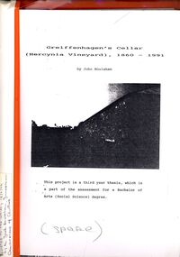
Book - STRAUCH COLLECTION: GREIFFENHAGENS CELLAR (HERCYNIA VINEYARD)
"Hercynia" was the largest vineyyard in the Bendigo District. It was started by Carl Wilhelm Greiffenhagen (William) and his cousins, twins, Carl and August Heine. The first vine cuttings were planted in 1860. The partners owned 300 acres at Axe Creek and in 1862 had 24 acres under vines and an orchard of 4 acres. By 1884 they had expanded to 30 acres of vines. They produced many award winning wines. August Heine ( 1832 - 1898) was born in Germany and came to Australia in 1854 with his twin brother Carl and their cousin William Greiffenhagen. Initially the three took up mining successfully but then the partnership bought 300 acres at Axe Creek and planted a vineyard. They also grew fruit and crops to feed the working horses. In 1870 August sold his interest in the vineyard and set up his own smaller vineyard at Sheepwash Gully. He had several business interests before he took up the caretaker position at the newly dug Weeroona lake, a position he held until his death. Carl Heine sold his interest in the vineyard in 1873 and returned to Germany. WIlliam Grieffenhagen (1834-1916) continued his very successful vineyard until the region was hit with a highly infectious vine disease in 1893. Although his own vines escaped infection, he was within the 2 mile quarantine area and was forced to dig out all his vines. He never replanted but depended on his orchard instead. He was a founding member of the Bendigo Agricultural Society and a local Shire councillor for several years. In 1870 he married Margaret Boyd.Binder containing information relating to Greiffenhagen's cellar (Hercynia Vineyard) 1860 - 1991 including black and white photographs & maps, compiled by John Houlahan as a third year thesis whichnis pat of the assessment for a Bachelor of Arts (Social Science) degree. Donated to the German Society 15/2/96 by the Grandfather of author Jack Houlahan.John Houlahanbook, bendigo, wineries, bendigo-history-axe creek- wineries- german -
 Ringwood and District Historical Society
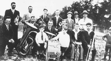
Photograph, Ringwood Municipal Band, Park Orchards, 1929
Written on back of photograph, "Ringwood Municipal Band which also at about the 1930s was the 24th Batt. Band. Post card size original photo was taken at Park Orchards 1929. Back row left to right: Sam Brown, Jim Jamison, Jim Walters, Geo Burns, Stan Saunders, Bill Fitzell & ?? Centre Row: Jack Bramwell (Bandmaster), Harry Knobbs,??, Tom Peters, ??, & Bill Brown. Front Row: Two small boys, Norm Jamison, & ??". -
 University of Melbourne, Burnley Campus Archives
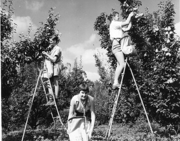
Photograph - Black and white print, Publicity Branch Victorian Department of Agriculture, Students Picking Fruit, 1958-1960
These students are from the first intake for the Diploma of Horticulture who graduated in 1961.Black and white photographs. Students picking apples and pears. The students are wearing special bags which attach by straps round the neck and around the waist, with a flap that opens at the bottom allowing the fruit to be removed. The bags are stamped "Burnley Gardens,". 7 photographs by the Publicity Branch Victorian Department Of Agriculture Ref. No. c.1317. (1) D Left to right: John Richards, Dorothy Issell, Helen Page, picking pears. Also see B92.560 enlarged. (2) E Doroth Issell picking apples. (3) F (2 copies) 6 students picking apples. (4) H Helen Page picking apples. (5) I John Richards, ?, Helen Page, picking apples. 3 unmarked photographs (6) 1 John Richards, Helen Page, Dorothy Issell, picking pears. This photograph used as an illustration in, "Green Grows Our Garden," A.P. Winzenried p99. (7, 8) 2, 3 John Richards, Dorothy Issell, Helen Page picking pears. fruit picking, apples, pears, diploma of horticulture, 1961, bags, john richards, dorothy issell, helen page, green grows our garden, a.p winzenried, students working outside, orchard