Showing 25590 items matching "plenty-township-estate"
-
 Eltham District Historical Society Inc
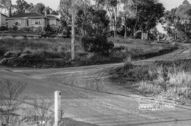
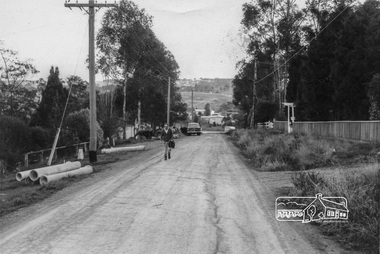
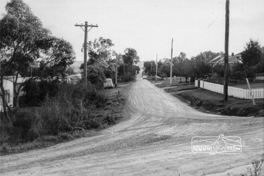
Photograph, Looking northeast up Alma Street from Para Road at intersection of Alma Street and Lees Road, Lower Plenty, c.July 1967, 1967
Packaged in "Filmpro King Size prints Definitely Better EST. 1918" envelope. Pencil notes: 36 shots $2.87 Eltham Shire J. McD and 19/7/67. Alma Street and Kett Street Lower Plenty c.July 1967.Black and white photographalma street, lees road, lower plenty, para road, houses, streets -
 Eltham District Historical Society Inc
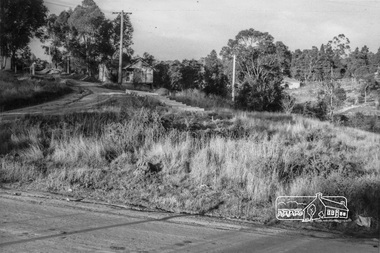
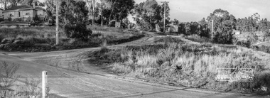
Photograph, Looking northeast up Alma Street from Para Road at intersection of Alma Street and Lees Road, Lower Plenty, c.July 1967, 1967
Packaged in "Filmpro King Size prints Definitely Better EST. 1918" envelope. Pencil notes: 36 shots $2.87 Eltham Shire J. McD and 19/7/67. Alma Street and Kett Street Lower Plenty c.July 1967.Digital composite of two black and white photographsalma street, lees road, lower plenty, para road, houses, streets -
 Eltham District Historical Society Inc
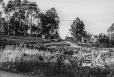
Photograph, Looking northeast up Alma Street from Para Road at intersection of Alma Street and Lees Road, Lower Plenty, c.July 1967, 1967
Packaged in "Filmpro King Size prints Definitely Better EST. 1918" envelope. Pencil notes: 36 shots $2.87 Eltham Shire J. McD and 19/7/67. Alma Street and Kett Street Lower Plenty c.July 1967.Black and white photographalma street, lower plenty, para road, houses, streets -
 Eltham District Historical Society Inc
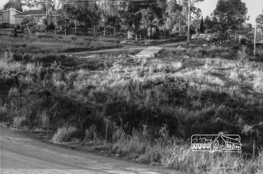
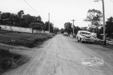
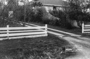
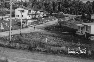
Photograph, Looking north up Para Road at intersection of Alma Street and Lees Road, Lower Plenty, c.July 1967, 1967
Packaged in "Filmpro King Size prints Definitely Better EST. 1918" envelope. Pencil notes: 36 shots $2.87 Eltham Shire J. McD and 19/7/67. Alma Street and Kett Street Lower Plenty c.July 1967.Black and white photographalma street, lower plenty, para road, houses, streets, lees road -
 Eltham District Historical Society Inc
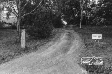
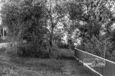
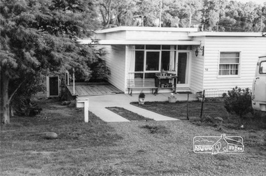
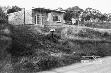
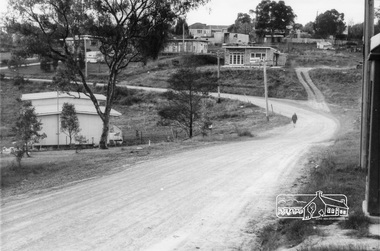
Photograph, 20 Para Road viewed from near 2 Alma Street, Lower Plenty, c.July 1967, 1967
Packaged in "Filmpro King Size prints Definitely Better EST. 1918" envelope. Pencil notes: 36 shots $2.87 Eltham Shire J. McD and 19/7/67. Alma Street and Kett Street Lower Plenty c.July 1967.Black and white photographalma street, lower plenty, houses, streets -
 Eltham District Historical Society Inc
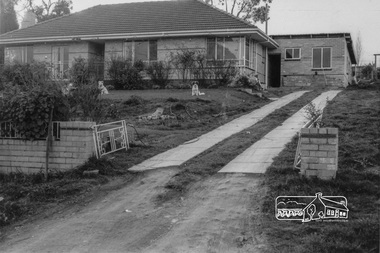
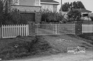
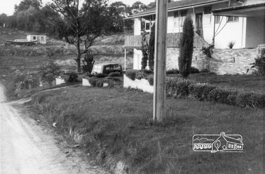
Photograph, 2 Alma Street (on right), Lower Plenty, c.July 1967, 1967
Packaged in "Filmpro King Size prints Definitely Better EST. 1918" envelope. Pencil notes: 36 shots $2.87 Eltham Shire J. McD and 19/7/67. Alma Street and Kett Street Lower Plenty c.July 1967.Black and white photographalma street, lower plenty, houses, streets -
 Eltham District Historical Society Inc
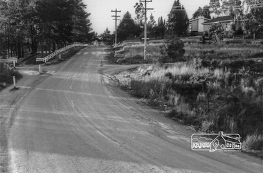
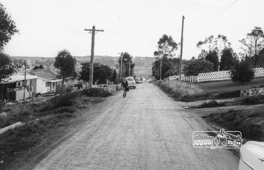
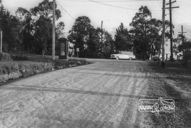
Photograph, Looking southwest along Alma Street to Para Road, Lower Plenty, c.July 1967, 1967
Packaged in "Filmpro King Size prints Definitely Better EST. 1918" envelope. Pencil notes: 36 shots $2.87 Eltham Shire J. McD and 19/7/67. Alma Street and Kett Street Lower Plenty c.July 1967.Black and white photographalma street, lower plenty, houses, streets -
 Eltham District Historical Society Inc
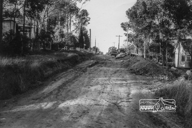
Photograph, Looking northeast along Alma Street to Para Road, Lower Plenty, c.July 1967, 1967
Packaged in "Filmpro King Size prints Definitely Better EST. 1918" envelope. Pencil notes: 36 shots $2.87 Eltham Shire J. McD and 19/7/67. Alma Street and Kett Street Lower Plenty c.July 1967.Black and white photographalma street, lower plenty, houses, streets -
 Eltham District Historical Society Inc
Photograph, Looking southwest along Alma Street to Para Road, Lower Plenty, c.July 1967, 1967
Packaged in "Filmpro King Size prints Definitely Better EST. 1918" envelope. Pencil notes: 36 shots $2.87 Eltham Shire J. McD and 19/7/67. Alma Street and Kett Street Lower Plenty c.July 1967.Black and white photographalma street, lower plenty, houses, streets -
 Eltham District Historical Society Inc
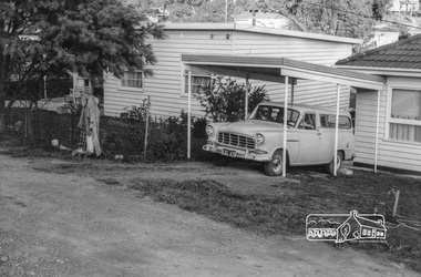
Photograph, 27 Alma Street, Lower Plenty, c.July 1967, 1967
Packaged in "Filmpro King Size prints Definitely Better EST. 1918" envelope. Pencil notes: 36 shots $2.87 Eltham Shire J. McD and 19/7/67. Alma Street and Kett Street Lower Plenty c.July 1967.Black and white photographalma street, lower plenty, houses, streets -
 Eltham District Historical Society Inc
Photograph, 43 Alma Street, Lower Plenty, c.July 1967, 1967
Packaged in "Filmpro King Size prints Definitely Better EST. 1918" envelope. Pencil notes: 36 shots $2.87 Eltham Shire J. McD and 19/7/67. Alma Street and Kett Street Lower Plenty c.July 1967.Black and white photographalma street, lower plenty, houses, streets -
 Eltham District Historical Society Inc
Photograph, Looking northeast along Alma Street near No. 44 (on right), Lower Plenty, c.July 1967, 1967
Packaged in "Filmpro King Size prints Definitely Better EST. 1918" envelope. Pencil notes: 36 shots $2.87 Eltham Shire J. McD and 19/7/67. Alma Street and Kett Street Lower Plenty c.July 1967.Black and white photographalma street, lower plenty, houses, streets -
 Eltham District Historical Society Inc
Photograph, 45 Alma Street, Lower Plenty, c.July 1967, 1967
Packaged in "Filmpro King Size prints Definitely Better EST. 1918" envelope. Pencil notes: 36 shots $2.87 Eltham Shire J. McD and 19/7/67. Alma Street and Kett Street Lower Plenty c.July 1967.Black and white photographalma street, lower plenty, houses, streets -
 Eltham District Historical Society Inc
Photograph, 48 Alma Street, Lower Plenty, c.July 1967, 1967
Packaged in "Filmpro King Size prints Definitely Better EST. 1918" envelope. Pencil notes: 36 shots $2.87 Eltham Shire J. McD and 19/7/67. Alma Street and Kett Street Lower Plenty c.July 1967.Black and white photographalma street, lower plenty, houses, streets -
 Eltham District Historical Society Inc
Photograph, 50 Alma Street, Lower Plenty, c.July 1967, 1967
Packaged in "Filmpro King Size prints Definitely Better EST. 1918" envelope. Pencil notes: 36 shots $2.87 Eltham Shire J. McD and 19/7/67. Alma Street and Kett Street Lower Plenty c.July 1967.Black and white photographalma street, lower plenty, houses, streets -
 Eltham District Historical Society Inc
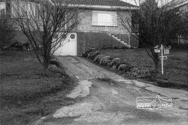
Photograph, 51 Alma Street, Lower Plenty, c.July 1967, 1967
Packaged in "Filmpro King Size prints Definitely Better EST. 1918" envelope. Pencil notes: 36 shots $2.87 Eltham Shire J. McD and 19/7/67. Alma Street and Kett Street Lower Plenty c.July 1967.Black and white photographalma street, lower plenty, houses, streets -
 Eltham District Historical Society Inc
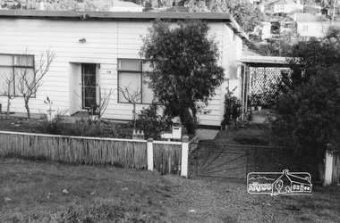
Photograph, 54 Alma Street, Lower Plenty, c.July 1967, 1967
Packaged in "Filmpro King Size prints Definitely Better EST. 1918" envelope. Pencil notes: 36 shots $2.87 Eltham Shire J. McD and 19/7/67. Alma Street and Kett Street Lower Plenty c.July 1967.Black and white photographalma street, lower plenty, houses, streets -
 Eltham District Historical Society Inc
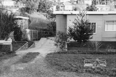
Photograph, 52 Alma Street, Lower Plenty, c.July 1967, 1967
Packaged in "Filmpro King Size prints Definitely Better EST. 1918" envelope. Pencil notes: 36 shots $2.87 Eltham Shire J. McD and 19/7/67. Alma Street and Kett Street Lower Plenty c.July 1967.Black and white photographalma street, lower plenty, houses, streets -
 Eltham District Historical Society Inc
Photograph, 53 Alma Street, Lower Plenty, c.July 1967, 1967
Packaged in "Filmpro King Size prints Definitely Better EST. 1918" envelope. Pencil notes: 36 shots $2.87 Eltham Shire J. McD and 19/7/67. Alma Street and Kett Street Lower Plenty c.July 1967.Black and white photographalma street, lower plenty, houses, streets -
 Eltham District Historical Society Inc
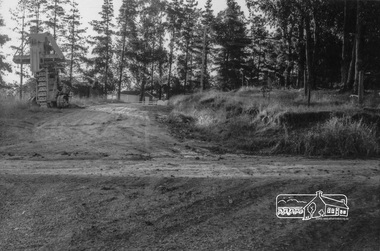
Photograph, Intersection of Kett Street (dirt road) with Airlie Road, Lower Plenty, c. July 1967, 1967
Packaged in "Filmpro King Size prints Definitely Better EST. 1918" envelope. Pencil notes: 36 shots $2.87 Eltham Shire J. McD and 19/7/67. Alma Street and Kett Street Lower Plenty c.July 1967.Black and white photographlower plenty, houses, streets, airlie road, kett street -
 Eltham District Historical Society Inc
Photograph, Looking southeast along Kett Street towards intersection with Alma Street, Lower Plenty, c.July 1967, 1967
Packaged in "Filmpro King Size prints Definitely Better EST. 1918" envelope. Pencil notes: 36 shots $2.87 Eltham Shire J. McD and 19/7/67. Alma Street and Kett Street Lower Plenty c.July 1967.Black and white photographlower plenty, houses, streets, kett street, alma street -
 Eltham District Historical Society Inc
Photograph, Looking west along Alma Street from Kett Street, Lower Plenty, c.July 1967, 1967
Packaged in "Filmpro King Size prints Definitely Better EST. 1918" envelope. Pencil notes: 36 shots $2.87 Eltham Shire J. McD and 19/7/67. Alma Street and Kett Street Lower Plenty c.July 1967.Black and white photographlower plenty, houses, streets, kett street, alma street -
 Eltham District Historical Society Inc
Photograph, Bramall house, 8 Kett Street, Lower Plenty, c.July 1967, 1967
Packaged in "Filmpro King Size prints Definitely Better EST. 1918" envelope. Pencil notes: 36 shots $2.87 Eltham Shire J. McD and 19/7/67. Alma Street and Kett Street Lower Plenty c.July 1967.Black and white photographlower plenty, houses, streets, kett street, bramall -
 Eltham District Historical Society Inc
Photograph, Looking towards the intersection of Kett Street with Main Road from 8 Kett Street, Lower Plenty, c.July 1967, 1967
Packaged in "Filmpro King Size prints Definitely Better EST. 1918" envelope. Pencil notes: 36 shots $2.87 Eltham Shire J. McD and 19/7/67. Alma Street and Kett Street Lower Plenty c.July 1967.Black and white photographlower plenty, houses, streets, kett street, main road -
 Eltham District Historical Society Inc
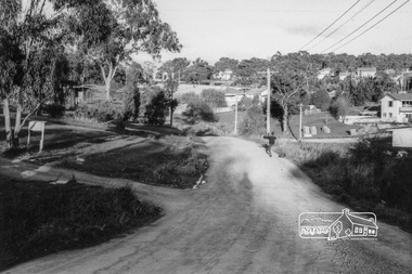
Photograph, Looking south along Kett Street to intersection with Main Road, Lower Plenty, c.July 1967, 1967
Packaged in "Filmpro King Size prints Definitely Better EST. 1918" envelope. Pencil notes: 36 shots $2.87 Eltham Shire J. McD and 19/7/67. Alma Street and Kett Street Lower Plenty c.July 1967.Black and white photographlower plenty, houses, streets, kett street, main road -
 Eltham District Historical Society Inc
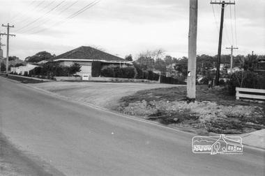
Photograph, 175 Main Road, cnr of Kett Street, Lower Plenty, c.July 1967, 1967
Packaged in "Filmpro King Size prints Definitely Better EST. 1918" envelope. Pencil notes: 36 shots $2.87 Eltham Shire J. McD and 19/7/67. Alma Street and Kett Street Lower Plenty c.July 1967.Black and white photographlower plenty, houses, streets, kett street -
 Eltham District Historical Society Inc
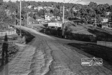
Photograph, Looking north along Kett Street from near the intersection with Main Road, Lower Plenty, c.July 1967, 1967
Packaged in "Filmpro King Size prints Definitely Better EST. 1918" envelope. Pencil notes: 36 shots $2.87 Eltham Shire J. McD and 19/7/67. Alma Street and Kett Street Lower Plenty c.July 1967.Black and white photographlower plenty, houses, streets, kett street, main road