Showing 17377 items
matching view-master
-
 Ringwood and District Historical Society
Photograph, Ringwood, England - Street View. (undated)
Catalogue card reads, "Ringwood, England." -
 Ringwood and District Historical Society
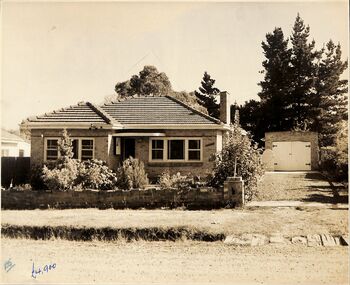
Photograph, 3 street view photographs of unidentified houses in Ringwood circa1960
One sepia and two black and white photographs of houses with prices in pounds, indicating prior to currency decimalisation in 1966.Photograph by The Ringwood Studio, Shop 14, Ringwood Shopping Centre. Phone WU7609 Copyright. -
 Ringwood and District Historical Society
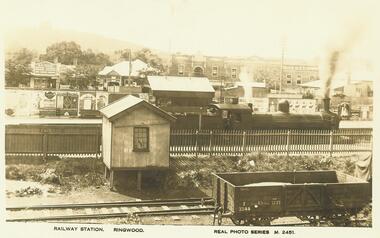
Photograph, Ringwood Railway Station, including view of platform advertising, Main Street shops, and Loughnan's Hill. c.1925
Inscription below photograph reads, "Railway Station, Ringwood. Real photo series M.2451." "c.1925". -
 Ringwood and District Historical Society
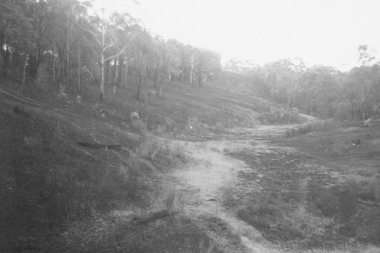
Photograph, View up range from the target pit at Ringwood Rifle Range, Jumping Creek Reserve after the January 1962 bushfires
Written on back of photograph, "Looking from target pit up range after fires, 1962." -
 Ringwood and District Historical Society
Photograph, 1973 view of the former site of Cass's School (1873-1894) at the corner of Everard Road and Maroondah Highway Ringwood East
Typed below photograph, "Site of Cass's School 1873-1894. Photo taken 1973. Present site of 'Lionsbrae'". -
 Ringwood and District Historical Society
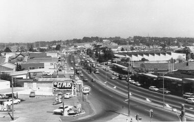
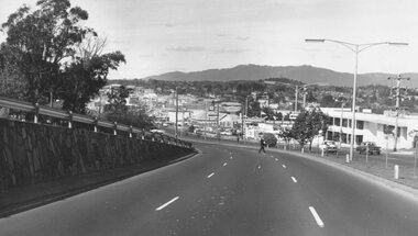
Photograph, Maroondah Highway West, Ringwood- 1969. Westward view from Ringwood Clocktower, cnr Maroondah Hwy and Wantirna Road
Black and white photographWritten on back of photograph: "Dec 1969, looking West. -
 Ringwood and District Historical Society
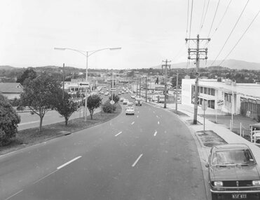
Photograph, Maroondah Highway West, Ringwood- 1969. Westward view from Ringwood Clocktower, cnr Maroondah Hwy and Wantirna Road
Black and white photographWritten on back of photograph: "Dec. 1969 from clock tower - looking west" -
 Ringwood and District Historical Society
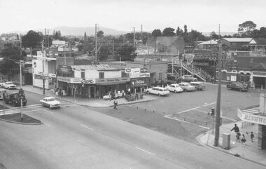
Photograph, View from Ringwood Clocktower overlooking Wantirna Road railway bridge and Thanet Street corner - Dec. 1969
Black and white photographWritten on back of photograph: "Wantirna Rd. from clocktower, 1969." -
 Ringwood and District Historical Society
Photograph, View from Ringwood Clocktower overlooking Wantirna Road railway bridge and Thanet Street corner - Dec. 1969
Black and white photographWritten on back of photograph: "Wantirna Rd bridge. from clocktower, 1969". Thanet Street corner. -
 Ringwood and District Historical Society
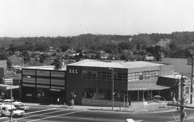
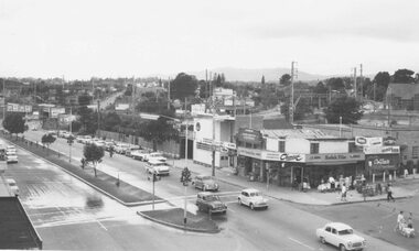
Photograph, Maroondah Highway West, Ringwood- 1969. View from Ringwood Clocktower overlooking Commonwealth Bank and SEC offices, cnr Maroondah Hwy and Ringwood Street, Ringwood - Dec. 1969
Black and white photographNil -
 Ringwood and District Historical Society
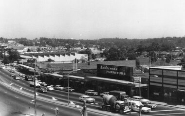
Photograph, Maroondah Highway West, Ringwood- 1969. View from Ringwood Clocktower overlooking Main Shopping Centre and Holeproof, Maroondah Hwy
Black and white photographWritten on backing sheet: "Dec. 1969. Holeproof at left". -
 Ringwood and District Historical Society
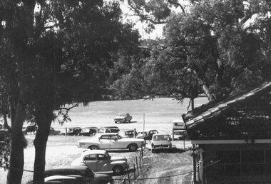
Photograph, View overlooking Ringwood Oval from rear of Town Hall, Maroondah Highway, Ringwood - c.1960s
Ringwood Oval written on back of photograph. -
 Ringwood and District Historical Society
Photograph, Maroondah Highway East, Ringwood in 1973. Eastward view along Maroondah Highway towards Mount Dandenong Road
Black and white photographTyped on back of photograph: "Maroondah Highway by the lake. Looking east towards Mt. Dandenong Rd. - 1973". Ringwood Lake is on the right hand side of the highway. -
 Ringwood and District Historical Society
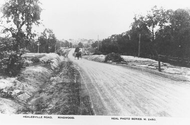
Photograph, Maroondah Highway East, Ringwood- c.1920. "Healesville Road, Ringwood" postcard featuring westward view along Whitehorse Road towards Mount Dandenong Road
4 photographs (2 large black and white, 2 small sepia postcard)Postcard labelled Healesville Road, Ringwood. Typed under large copy: "Looking down a dry Maroondah Highway from outside (eventual) Civic Centre site towards Mt. Dandenong Rd corner." -
 Ringwood and District Historical Society
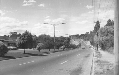
Photograph, Maroondah Highway East, Ringwood- 1973. Westward view from Braeside Avenue along Maroondah Highway
Black and white photographWritten on rear of backing sheet: "Ringwood from Braeside Av. 9/73". -
 Ringwood and District Historical Society
Photograph, Maroondah Highway West- Ringwood- c1949. Easterly view from Heatherdale Road along Whitehorse Road
Black and white photograph (2 large, 1 small)Written on back of photograph: "Main Street from Ringwood hill (near Heatherdale Road) c1949" -
 Ringwood and District Historical Society
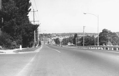
Photograph, Maroondah Highway West, Ringwood- 1974. Easterly view from Heatherdale Road
Black and white photographWritten on backing sheet, "Descending Ringwood Hill into Ringwood - 1974". -
 Ringwood and District Historical Society
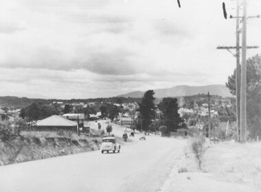
Photograph, Maroondah Highway West, Ringwood- 1973. Easterly view from Heatherdale Road
Black and white photographWritten on backing sheet, "Ringwood, photo used in history of Ringwood. Figure on road is Ron Pullin, photo taken by Brian Pump - 1973". -
 Ringwood and District Historical Society
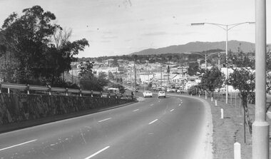
Photograph, Maroondah Highway West, Ringwood- 1974. Easterly view from Heatherdale Road, 1974
Black and white photographWritten on backing sheet, "Coming into Ringwood, 1974".bill patterson holden, 1970s, car dealers, main streets, suburban life, traffic -
 Ringwood and District Historical Society
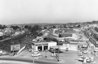
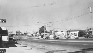
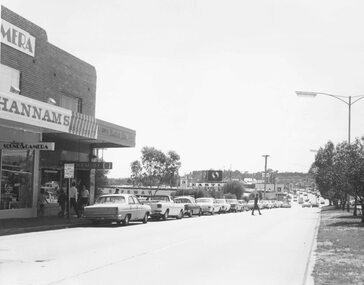
Photograph, Maroondah Highway west, Ringwood- 1965. Easterly view towards Esso petrol station and cool stores on opposite corners of Wantirna Road
Black and white photographWritten beneath photograph, "1965 - Looking east to old cool store site." Written on rear of backing sheet, "1965. Cool store site, corner Maroondah Highway and Wantirna Road". -
 Ringwood and District Historical Society
Photograph, Maroondah Highway, Ringwood - View of Town Hall - Dec 1969 - 2 Photographs
Black and white photograph of street looking towards Midway Arcade and old town hall.Written on reverse of VC777-1 "Dec 1969 OLD TOWN HALL" -
 Ringwood and District Historical Society
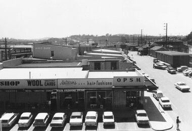
Photograph, View from clocktower overlooking Railway Place, Ringwood - December 1969
Antwan's Hair Fashions and OPSM in foreground, ANZ bank in background, taken from clocktowerWritten on backing sheet, "Railway Place, December 1969". -
 Ringwood and District Historical Society
Photograph, Town Hall rooftop view of Railway station entrance, Ringwood, Vic. - c.1964
Station entrance from town hall looking east, 4 copiesPhotograph dated 1962. -
 Ringwood and District Historical Society
Photograph, Town Hall rooftop view of Railway station entrance, Ringwood, Vic. - c.1964
Ringwood railway station taken from town hall, Ringwood Cycles, CE Carter.Photograph dated "1962" -
 Ringwood and District Historical Society
Photograph, Town Hall rooftop view of Railway station entrance, Ringwood, Vic. - c.1964
Ringwood station entrance circa 1962, chemist and ANZ bank to left, shot1, 4 photosPhotograph dated 1962. -
 Ringwood and District Historical Society
Photograph, Maroondah Highway Central, Ringwood. Easterly view towards Warrandyte Road intersection- 1974
Black and white photographWritten on backing sheet, "Main St. looking east to Warrandyte Rd. 1974". -
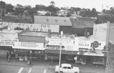 Ringwood and District Historical Society
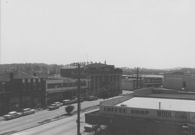
Photograph, Shops Maroondah hwy (built 1927) Tarax Milk Bar, 2 copies. View from Town Hall roof 1962
Includes C.E.Carter & Son, Ringwood Lamb Centre, Simpsons Bakery, Roberts Milk Bar -
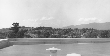 Ringwood and District Historical Society
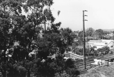
Photograph, View from Civic Centre roof - September 1973
Written on backing sheet, "From Civic Centre roof - September 1973". -
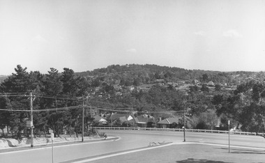 Ringwood and District Historical Society
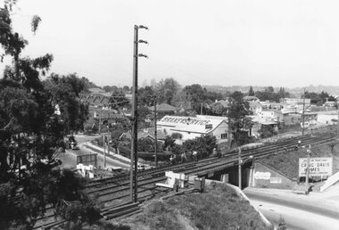
Photograph, View from Civic Centre, Braeside Avenue, overlooking Maroondah Highway towards Loughnan's Hill - 1973
Black and white photograph looking towards T-intersection towards housing and trees on hill. -
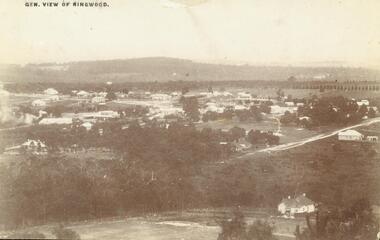 Ringwood and District Historical Society
Photograph, View of Ringwood in 1912 taken from Loughnan's Hill
Black and white photograph looking across valley with small settlement. Mountains in background. (2 postcard copies and 2 enlargements). House in right foreground is in what is known now as Wildwood Grove. The dirt track above is Ringwood St. Field above is the football field with diagonal track coming out at Melbourne Street, later Eastland shopping complex. House on left is in Adelaide Street. Warrandyte Road is above it."Typed on back of one enlargement, "Copied from a postcard mailed in Ringwood, 1912, copied 1959. House in right foreground is in what is known now as Wildwood Grove. The dirt track above is Ringwood St. Field above is the present football field with diagonal track coming out at Melbourne Street. House on left is in Adelaide Street. Warrandyte Road is above it." House bottom RH side was still there in 1970 in Wildwood Grove (off Ringwood St). Ringwood Street lower centre to RH side. Field above Ringwood Street is the football field with diag. walk coming out at Melbourne Street. House on LH side in Adelaide Street. Warrandyte above it. Steam at LH from Bently's Steam Joinery at corner Main Street and Warrandyte Road.