Showing 8370 items matching " bridge"
-
 Kew Historical Society Inc
Photograph, Burke Road Bridge, 1930s
Without bridges, Kew remained cut off from the City of Melbourne, only being accessible by Punt. Private and public bridges were constructed from the 1850s, beginning with the Hawthorn Bridge linking Bridge and Burwood Roads. A bridge across the Yarra at Burke Road was created as early as 1873. Since that first wooden bridge, a number of later bridges, typically on concrete pylons have been built, in 1926 and again during the 1970s.Sepia, faded photograph of the Burke Road Bridge linking East Kew and Ivanhoe. The previous bridge, constructed in 1926 was submerged beneath the flood waters in the 1934 mega-flood of the Yarra.burke road bridge (kew), bridges -- river yarra -
 Chelsea & District Historical Society Inc
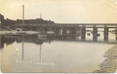
Photograph - Patterson River, Rail and Road Bridge
The first bridge over the river was built in the early 1880's, prior to this it was a pontoon bridge.Black and white photo of the road bridge (Point Nepean / Nepean Highway) and rail bridge, near the mouth of the Patterson River. Taken from the mouth of the river.patterson river, road bridge, rail bridge, chelsea, transport, patterson river bridge, carrum bridge -
 Phillip Island and District Historical Society Inc.
Photograph, Phillip Island Bridge, 1968/9
Construction of 2nd 1969 Bridge which was opened November 1969. From the Jack Jenner CollectionNew Bridge almost completed. San Remo in background with rising hill. Tractor on Bridge.local history, photographs, civil engineering, bridges, phillip island bridges, black & white photograph, jack jenner collection, public construction -
 Lakes Entrance Historical Society
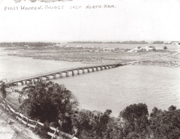
Photograph, Timber North Arm bridge, Lakes Entrance Victoria, 1900 c
Black and white photograph of the timber bridge over North Arm showing Club Hotel and guest houses facing front lake Lakes Entrance VictoriaFirst Wooden Bridge over North Armbridges, engineering, gippsland lakes -
 Phillip Island and District Historical Society Inc.
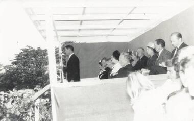
Photograph, Phillip Island Bridge Opening, 1969
Opening of 2nd Bridge. Speaker President Shire of Bass. This Bridge replaced the Suspension Bridge. From the Jack Jenner Collection.Opening of second Bridge 1969. Speaker, President, Shire of Basslocal history, photographs, civil engineering, bridges, opening of phillip island bridge, black & white photograph, jack jenner collection, phillip island bridges, public construction -
 Phillip Island and District Historical Society Inc.
Photograph, Phillip Island Bridge, 1968/9
Construction of 2nd 1968/69 Bridge connecting San Remo with Newhaven. From the Jack Jenner CollectionPhotograph showing two Bridges. Old Suspension Bridge on left. 1969 Bridge with all pillars in and decking completed only in foreground - taken from San Remolocal history, photographs, civil engineering, bridges, phillip island bridges, black & white photograph, jack jenner collection, public construction -
 Linton and District Historical Society Inc
Photograph, Bridge Opening
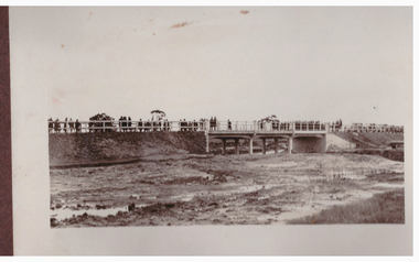
Part of photograph album donated by Mrs Faull. The picture shows the opening of the Glenelg Highway Bridge over the Woady Yaloak Creek between Linton and Scarsdale.Black and white photograph of bridge opening. Bridge in background with people and cars.events, bridge openings, faull collection, woady yaloak creek -
 Falls Creek Historical Society
Photograph - Dick Stericker & Hans Fisher building bridge 1961
This item is from the private collection of George Shirling of Red Onion, Falls Creek. It depicts Dick Stericker & Hans Fisher constructing a wooden bridge. They both arrived in Falls Creek in the early 1960s. Hans worked on the slopes in summer and in winter, including building access bridges over the race-line as shown in this photograph. In 1965 Hans started as the chef Koki Alpine Lodge owned by George Shirling. He later worked as cook at various Falls Creek eating houses, as well as working for the lift company and slope maintenance People like Hans made Falls Creek. He passed away at Noosa, Queensland on 18th January 2022. George Shirling arrived in Falls Creek in 1962. He engaged Phil Nowell to build the original Koki Alpine Lodge which opened in 1965 with 14 beds. George operated the lodge with Michael “Baldy” Blackwell as manager. He also graduated in sport psychology in 1981 and was invited to become team psychologist for the Australian Winter Olympic team which went to Albertville, France, in 1992. He later owned the Red Onion Chalet. George credited the success of Koki to “Baldy” Blackwell. “Baldy” and Phil Nowell started the Trackers Mountain Lodge in partnership during the 1980s. In 1971 George sold Koki Lodge to Sigi Doerr. In 2024 the renamed Koki Alpine resort remains a highly popular destination in Falls Creek. George Shirling passed away on 27th February 2023. He had remained actively involved in Falls Creek and was generous with his time and knowledge, always an amazing supporter of The Falls Creek Museum and Falls Creek Village.This item is significant because it features two prominent members of the Falls Creek community.A black and white photograph of Dick Stericker & Hans Fisher taking a break whilst building a bridge. A typed George Shirling Collection number and description is attached. On label: ITEM NO. 148 Dick Stericker & Hans Fisher - smoko - while building bridge over raceline - Village T-bar, 1961george shirling, red onion, hans fisher -
 Eltham District Historical Society Inc
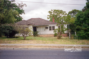
Photograph, Margaret Ball, 74 Bridge Street, Eltham, Nov-Dec 1999 now part of units 72-74 Bridge Street, 1999
The Margaret Ball (Pre 1960s Houses) Collection was a personal project initiated to mark the year 2000 and arose as a result of the disappearance of many pre-1960s parts of Eltham due to development. Approximately 200 pre-1960s style houses that were left in Eltham between Main Road and east to Bible Street, between Cecil Street to the north and south to Dalton Street were photographed in late 1999. Not all of the houses could be photographed; some because the garden or trees blocked the view of the house, others because of rubbish or cars were in the way, some because people were working on the house or in the gardens at the time.Roll of 35mm colour negative film, 7 stripsKodak GC 400-6eltham, houses, streets, margaret ball (pre 1960s houses) collection, bridge street -
 Lakes Entrance Historical Society
Photograph, Caire, Nicholas John, Swing Bridge Sale Victoria c1905, 1905c
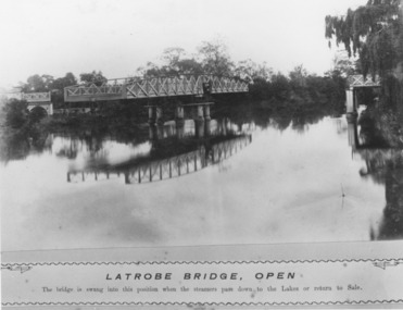
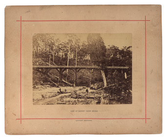
Latrobe Bridge - Open. The bridge is swung into this position when the steamers pass down to the Lakes or return to Sale.Black and white photograph of the Latrobe River Bridge over the Latrobe River, shows the bridge open to river traffic, with a good view of the supporting structure. Sale Victoriawaterways, bridges, civil engineering -
 Ballarat Heritage Services
Photograph - Mounted photograph, Nicholas J. Caire, View of Sailors' Creek Bridge, c1877
Original photograph of a bridge at Sailors' Creek, near Daylesford. daylesford, bridge, nicholas caire, sailors' creek -
 Sunbury Family History and Heritage Society Inc.
Photograph, Catanery Bridge, Bulla, c1980s
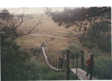
The narrow swing catanery bridge was built behind the school across the Deep Creek downstream from the bluestone Bulla Bridge. It was built so that children who lived on the south side of Bulla Township could access the school more easily and in shorter time than if they had to go by the main roads.The bridge was constructed in the days when most children walked to school. The use of this bridge cut the children's travel time and distance to school quite considerably and was used for many years until the school was closed in 1996.A coloured photograph of the children on a narrow swing bridge and the path they used to approach the bridge over open ground. bulla primary school, swing bridge, bridges, catanery bridge -
 Eltham District Historical Society Inc
Negative - Photograph, Russell Yeoman, Cottles Bridge over Diamond Creek, Cottles Bridge-Strathewan Road, Cottlesbridge, c.1970
Cottles Bridge over Diamond Creek, Cottles Bridge-Strathewen Road, CottlesbridgeRoll of 35mm black and white negative film, 4 of 7 stripsIlford HP4bridge, cars, cottles bridge, cottles bridge-strathewen road, diamond creek (creek) -
 Phillip Island and District Historical Society Inc.
Photograph - Post Card, Suspension Bridge, 1940's
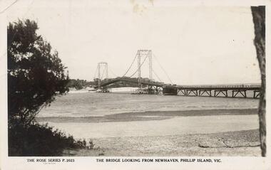
One of a collection of 18 photographs & postcards donated by Jill Yeoman. The Suspension Bridige was built during 1940. Postcard to Mrs Hughes & Lilly from Rita telling of a nice holiday visiting various towns and enjoying New Year's Eve fireworks on the Cowes beach.Black & White postcard of the Suspension Bridge from Newhaven, Phillip Island, to San Remo The Rose Series P. 2023. The bridge looking from Newhaven, Phillip Island, Vic.suspension bridge phillip island, phillip island bridge, jill yeoman -
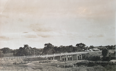
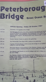 Peterborough History Group
Pamphlet, Road Construction Authority, Peterborough Bridge, 1987
Printed to celebrate the official opening of the new bridge in 1987.The bridge across he river is a major access point and the old bridge had become decrepit and the construction of the new bridge was important. The official opening was a significant event.Pamphlet for the official opening of the new bridge in 1987. 2 A4 pages with a view of the old and new bridges, describing the construction of both.curdies river, great ocean road, bridges, peterborough, peterborough bridge -
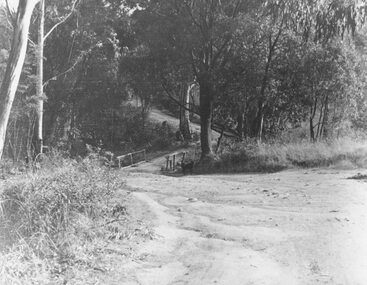
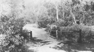 Ringwood and District Historical Society
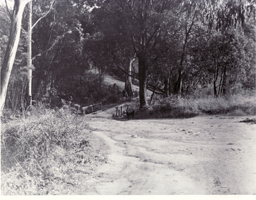
Photograph, Deep Creek bridge and road c.1935
Black and white photograph of narrow unmade road showing narrow bridge with wooded balustrades. Forested area at edge of roadway.Typed below photograph, "Deep Creek bridge and road. c.1935". -
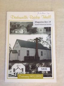 Stawell Historical Society Inc
Book, Rhonda Poholke, Dadswells Bridge Hall Centenary 1905/2005, 2005
A book commemerating the Centenary of the Dadswells Bridge HallWhite Card with lime green print and border enclosing five b/w photos of the Dadswells Brigde Hall.Dadswells Bridge Hall Centenary 1905-2005stawell -
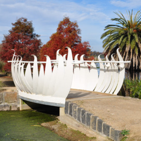 City of Ballarat
Artwork, other - Public Artwork, Swan Pool Bridge By Thomson Hay Landscape Architects, c2013
Swan Pool forms the southern gateway to the ‘Fairyland’ area on the western shore of Lake Wendouree, Ballarat. The new bridge was built c2013 and designed based on the form of water lily flowers. The sculptural form of the bridges enhances the ‘Fairyland’ experience for children and adults alike.white decorative steel bridge edgings -
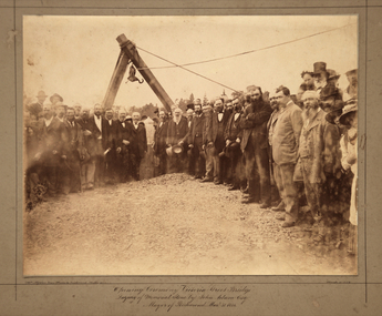 Kew Historical Society Inc
Photograph, Opening Ceremony Victoria Street Bridge: Laying of memorial stone by John Adam Esq. Mayor of Richmond, 1884
A formal group photograph of the grand opening of the Victoria Street Bridge on March 31 1884. The Argus was to report that: ‘The ceremony of laying the memorial stone of the Victoria-bridge, which connects Kew and Hawthorn with Richmond and Collingwood, was performed yesterday afternoon by the mayor of Richmond (Mr John Adam) in the presence of a large assemblage. Among the gentlemen present at yesterday’s proceedings were the mayor of Collingwood (Mr. M. Dwyer), the Mayor of Melbourne (Councillor C. Smith, M.L. A.) the mayor of Kew (Mr. Barnard), Mr. J. A. B. Koch and Mr. W. W. Shelley (ex mayors of Richmond), Mr. Joseph Bosisto, M.L.A., the Hon. L. L. Smith, Councillor De Mole (ex mayor of Kew), Mr. Jas. Lancashire and Mr. Winter (ex mayors of Ricmond), Mr. Walker (ex mayors of Collingwood), Mr. Johnson (engineer), Mr. C. Rowan, C.E. (engineer of the bridge alterations) and the town clerks of Richmond, Collingwood and Kew.’ Following the opening ceremony ‘… a ponderous steam roller was driven over the structure, with a view to test, or rather to demonstrate its stability … Most of the gentlemen present walked over the bridge, after which they were grouped by a photographer, with the memorial stone as a central feature, and several views of the scene were taken’.An original, rare silver albumen mounted and titled photograph of an important event in 19th century Melbourne.Original photograph mounted on display card of the opening of the Victoria Street Bridge. The original photograph is very faded and has been enhanced to improve the image's viewability.On the reverse of the card is an indecipherable stamp and an inscription identifying the photographers. "T. W. & C. A. McAlpine Bros, Photographers &., Campbell Parade East Richmond Melbourne March 31.1884victoria street bridge, john adam, m. dwyer, c. smith, barnard, j.a.b. koch, w.w. shelley, bridge, kew, collingwood, l.l. smith, joseph bosisto -
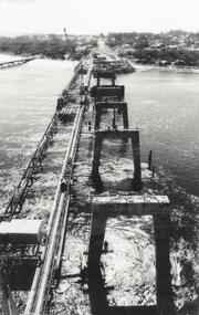
 Phillip Island and District Historical Society Inc.
Photograph, Phillip Island Bridge, 1968/9
1969 Bridge construction showing Suspension Bridge in background.Girders on partly built Bridge. Crane in background - close-up at low tide.local history, photographs, civil engineering, bridges, phillip island bridge (1969), black & white photograph, jack jenner collection, phillip island bridges, public construction -
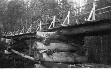 Kinglake Historical Society
Log Bridge Kinglake
post card depicting horse and cart crossing log bridge at Kinglakeearly post card of Kinglake area including bridge and transportpost card of log bridge Kinglakekinglake, post card, log bridge, horse cart -
 Ballarat Heritage Services
Photograph, Concrete Bridge Over Lake Daylesford, 2020, 2020
Colour photographs of the concrete bridge over laker Daylesford built by the Country Road Board in 1929.lake daylesford, bridge, concrete bridge -
 Whitehorse Historical Society Inc.
Photograph - B/W Photograph, Bridge at Deep Creek Road Mitcham. Circa 1940
Black and white photo of bridge at Deep Creek Road, Mitcham which leads to Loughnan's Hill.deep creek road, mitcham, bridge -
 Phillip Island and District Historical Society Inc.
Photograph, Phillip Island Bridge
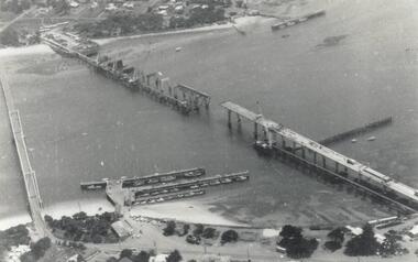
View taken from San Remo looking across bay to Phillip Island. Main section of bridge close up showing framework, arches and wires.Bridge - main sectionlocal history, photographs, bridges, san remo, black & white photograph, mona condrick -
 Linton and District Historical Society Inc
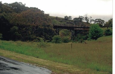
Photograph, Dilapidated bridge over Springdallah Creek, Happy Valley/Piggoreet, 2010
This bridge was built in the 1880s. By the 1980s it was in a dilapidated condition and was replaced. The old bridge was further damaged by storms and flooding in November 2010 and January 2011. (The newer bridge was completely washed away when the Springdallah Creek flooded in January 2011.) In 2025, little remains of the old bridge.Colour photograph of a trestle bridge spanning Springdallah Creek, Linton-Piggoreet Road.trestle bridges, old springdallah bridge -
 Stawell Historical Society Inc
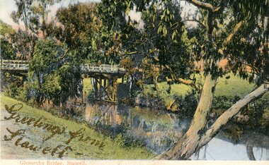
Photograph, Greetings from Stawell - Glenorchy Bridge -- Postcard
Postcard Front - Glenorchy bridge over water with gums in colourGreetings from Stawell - Gold Pen. Bridge supports. Note from Mother. also gold pen. Also parts of trees -
 Ringwood and District Historical Society
Photograph, Deep Creek Road bridge early 1900s
Black and white photograph taken from unmade road. Road zigzags over bridge with wooden balustrades. Bushland setting. (3 copies)Typed below photograph, "Deep Creek Road bridge in the early days". -
 Phillip Island and District Historical Society Inc.
Photograph, Phillip Island Bridge, 1968/9
The 2nd Bridge under construction which replaced the Suspension Bridge built in 1940. From the Jack Jenner Collection.Building of second Bridge under construction between San Remo and Newhaven.local history, photographs, civil engineering, bridges, phillip island bridges, black & white photograph, jack jenner collection, public construction -
 Federation University Historical Collection
Technical Drawing, Drawing of a Bridge Structure, 1924
Pencil on paper student's technical drawing of a bridge structure technical drawing, engineering drawing, g. murrowood, drawing of a bridge structure, bridge -
 Ballarat Heritage Services
Photograph, Bridge
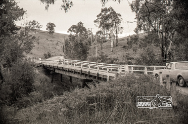
Associated with Carisbrook.A new concrete bridge over a creek near Carisbrook.em22, bridge, landscape, river, carisbrook