Showing 493 items matching " county of bendigo"
-
 Bendigo Historical Society Inc.
Map - MARONG : COUNTY OF BENDIGO, June 1953
... MARONG : COUNTY OF BENDIGO....Map> Marong, County of Bendigo, Nerring, Sandhurst..., County of Bendigo, Nerring, Sandhurst, Lockwood, Shelbourne ...Map> Marong, County of Bendigo, Nerring, Sandhurst, Lockwood, Shelbourne, Woodstock, Leichardt, Bullock Creek, Fletcher Creek, Township of Marong, Bendigo Railway Line, Marong Railway Station, Crusoe Aqueduct. Drawn and reproduced at the Dept. of Lands and Survey, Melbourne, Victoria. June 1953. Price 2/-. By authority W.M. Houston, Government Printer. (number 74 in map cupboard 1)W.M. Houston, Government Printer.map, bendigo, marong -
Bendigo Historical Society Inc.
Map - DIGGORRA PARISH : COUNTY OF BENDIGO, 6-9-21
... DIGGORRA PARISH : COUNTY OF BENDIGO....Map. Parish of Diggorra, County of Bendigo, Parish... of Diggorra, County of Bendigo, Parish of Bamawm, Rochester West ...Map. Parish of Diggorra, County of Bendigo, Parish of Bamawm, Rochester West, Pannoomilloo, Warragamba, Minto, Egerton, Elmore, Northern Railway, Parish of Ballendella. Elmore /Cohuna Railway. Photo-Lithographed at the Department of Lands and Survey, Melbourne by W.J. Butson, 6-9-21, Price 1/-.. By authority A.J. Mullett, Government Printer. (number 57 in map cupboard 1)A.J. Mullett, Government Printer.map, bendigo, diggorra -
Bendigo Historical Society Inc.
Map - JANIEMBER EAST : COUNTY OF BENDIGO, 15-1-34
... JANIEMBER EAST : COUNTY OF BENDIGO....Map. Janiember East, County of Bendigo, Jarklan, Pompapiel.... Janiember East, County of Bendigo, Jarklan, Pompapiel, Yarrayne ...Map. Janiember East, County of Bendigo, Jarklan, Pompapiel, Yarrayne, Powlet, Janiember West, Serpentine Creek, Caney's Blind Creek Long Plain Creek, Loddon River. By authority : H.J. Green, Govt. Printer, Melbourne. Drawn and reproduced at the Department of Lands and Survey, Melbourne, Victoria. Price 2/-. 15-1-34. (number 45 in map cupboard 1)H.J. Green, Govt. Printer, Melbourne.map, bendigo, janiember east -
Bendigo Historical Society Inc.
Map - MARONG : COUNTY OF BENDIGO, June 1953
... MARONG : COUNTY OF BENDIGO....Map. Marong, County of Bendigo, Nerring, Sandhurst..., County of Bendigo, Nerring, Sandhurst, Lockwood, Shelbourne ...Map. Marong, County of Bendigo, Nerring, Sandhurst, Lockwood, Shelbourne, Woodstock, Leichardt, Fletcher Creek, Bullock Creek, Township of Marong, Marong Railway Station, Bendigo Railway Line, Spring Creek, Crusoe Aqueduct. By authority W.M. Houston, Government Printer. Drawn and reproduced at the Department of Lands and Survey, Melbourne, Victoria. June 1953. Price 2/-. (number 73 in map cupboard 1)W.M. Houston, Government Printermap, bendigo, marong -
Bendigo Historical Society Inc.
Map - YALLOOK : COUNTY OF BENDIGO, 1957
... YALLOOK : COUNTY OF BENDIGO...Map. Yallook, County of Bendigo, Talambe, Neilborough.... Map. Yallook, County of Bendigo, Talambe, Neilborough ...Map. Yallook, County of Bendigo, Talambe, Neilborough, Yarraberb, Salisbury, Pompapiel. Drawn and reproduced at the Department of Lands and Survey, Melbourne,1957. Distances shown on the plan are derived from original surveys of varying dates and whilst approximately correct do not necessarily conform to modern standards of accuracy. For survey information application should be made to the central plan office, or to the office of titles. Some ink scibbles appear at the right top of this map. Price 2/-. (number 14 in map cupboard 1)By Authority W.M.Houston, Govt.Printer,Melbourne.map, bendigo, yallook -
Bendigo Historical Society Inc.
Map - ELLESMERE : COUNTY OF BENDIGO, 18-1-1943
... ELLESMERE : COUNTY OF BENDIGO...Map. Ellesmere, County Bendigo, Bagshot, Wellsford, Axedale.... Ellesmere, County Bendigo, Bagshot, Wellsford, Axedale, Muskerry ...Map. Ellesmere, County Bendigo, Bagshot, Wellsford, Axedale, Muskerry, Goornong, Bendigo Creek, Bendigo to Echuca- Northern Railway Line, Campaspe River, Sugarloaf Trig.Station. Township of Fosterville.By Authority: H.E. Daw, Govt. Printer, Melbourne. Drawn ad reproduced at the Dept. of Lands and Survey, Melbourne . 18-1-1943.Price 2/-. (number 37 in map cupboard 1)H.E. Daw, Government Printer, Melbourne.map, bendigo, ellesmere -
Bendigo Historical Society Inc.
Map - SANDHURST : COUNTY OF BENDIGO (PART), Circa 1940's
... SANDHURST : COUNTY OF BENDIGO (PART)... 195 in Map Cupboard 1) Map SANDHURST : COUNTY OF BENDIGO (PART) ...Map: Large scale (2 chains=1') of part of the city of Bendigo. Showing the area from Sommerville St. to Edwards Rd. Flora Hill ( number 195 in Map Cupboard 1)map, bendigo, city streets, bendigo, flora hill, sommerville st. -
 Bendigo Historical Society Inc.
Map - Marong County of Bendigo
... Marong County of Bendigo...Bendigo Historical Society Inc. Bendigo Historical Society ...Map of Marong. Drawn and reproduced at the Dept. of Lands and Survey, Melbourne. By authority: W.M. Houston Government Printer. June 1953.On the back in blue pen: certified plan parish Marong, signed minister and seal affixed for land S sec.72 evidence act. I certify that this a true plan parish Marong (signature illegible) minister for lands.map, marong -
 Bendigo Historical Society Inc.
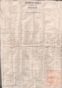
Map - MAP. WARRAGAMBA. COUNTY OF BENDIGO, 1915
... MAP. WARRAGAMBA. COUNTY OF BENDIGO.... Melbourne by W. J. Butson. Map MAP. WARRAGAMBA. COUNTY OF BENDIGO. ...Map. Warragamba. Colunty of Bendigo. Pannoomilloo. Minto. Diggorra. Kamarooka Photographedat the Department of LANDS AND Survey Melbourne by W. J. Butson. -
 Bendigo Historical Society Inc.
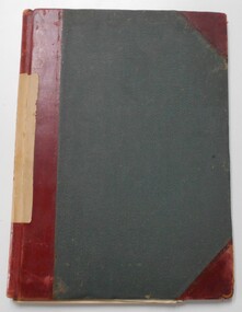
Document - LANDS OFFICE : TANDARRA ESTATE, COUNTY OF BENDIGO, 1906 - 1920
... LANDS OFFICE : TANDARRA ESTATE, COUNTY OF BENDIGO.... Document LANDS OFFICE : TANDARRA ESTATE, COUNTY OF BENDIGO ...Document: green bound hard cover journal with red spine binding and corners. On spine ' Tandarra' written in black. Journal contains details of allotments leased in the Tandarra Estate. Maps and letters relating to blocks are enclosed. LH page: details of lessee, improvements (year range 1906 - 1920) , RH page: residence, population, results of cultivation, stock etc., remarks re lessee's gains or losses each year.Land and Survey Officerland leases, tandarra, bendigo, sandhurst, lands office, land settlement -
 Bendigo Historical Society Inc.
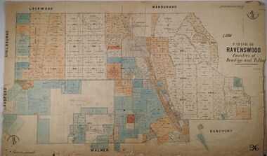
Map - PARISH OF RAVENSWOOD, 3/04/1875
... County of Bendigo...Map: Parish of Ravenswood, Counties of Bendigo and Talbot...MAP Bendigo parish plan Ravenswood County of Talbot County ...Map: Parish of Ravenswood, Counties of Bendigo and Talbot. Parish planmap, bendigo, parish plan, ravenswood, county of talbot, county of bendigo -
 Bendigo Historical Society Inc.
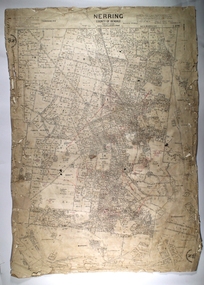
Map - NERRING, 25/08/1903 ?
... County of Bendigo...Map: Parish of Nerring, County of Bendigo. Parish plan...MAP Bendigo rural Nerring County of Bendigo Map: Parish ...Map: Parish of Nerring, County of Bendigo. Parish plan Canvas backedmap, bendigo, rural, nerring, county of bendigo -
Bendigo Historical Society Inc.
Map - JANIEMBER WEST, 18/02/1913
... County of Bendigo...Map: Parish of Janiember West, County of Bendigo ( number... Bendigo rural Janiember West County of Bendigo Map: Parish ...Map: Parish of Janiember West, County of Bendigo ( number 140 in Map Cupboard 1)map, bendigo, rural, janiember west , county of bendigo -
Bendigo Historical Society Inc.
Map - NERRING, August 1952
... county of Bendigo...Map: Nerring, County of Bendigo. Parish plan ( number 180... Bendigo parish plan Nerring county of Bendigo Map: Nerring, County ...Map: Nerring, County of Bendigo. Parish plan ( number 180 in Map Cupboard 1)map, bendigo, parish plan, nerring, county of bendigo -
Bendigo Historical Society Inc.
Map - HUNTLY, August 1945
... County of Bendigo...Map: Huntly, County of Bendigo, Parish plan ( number 168... Bendigo parish plan Huntly County of Bendigo Map: Huntly, County ...Map: Huntly, County of Bendigo, Parish plan ( number 168 in Map Cupboard 1)map, bendigo, parish plan, huntly, county of bendigo -
Bendigo Historical Society Inc.
Map - BAGSHOT, November 1948
... County of Bendigo...Map: Bagshot, County of Bendigo. Parish plan ( number 167... Bendigo parish plan Bagshot County of Bendigo Map: Bagshot, County ...Map: Bagshot, County of Bendigo. Parish plan ( number 167 in Map Cupboard 1)map, bendigo, parish plan, bagshot, county of bendigo -
Bendigo Historical Society Inc.
Map - LYELL, 16/04/1935
... County of Bendigo...Map: Lyell, County of Bendigo. Parish plan ( number 166... Bendigo parish plan Lyell County of Bendigo Map: Lyell, County ...Map: Lyell, County of Bendigo. Parish plan ( number 166 in Map Cupboard 1)map, bendigo, parish plan, lyell, county of bendigo -
Bendigo Historical Society Inc.
Map - MARONG, June 1953
... County of Bendigo...Map: Marong, County of Bendigo. Parish plan ( number 164... Bendigo parish plan Marong County of Bendigo Map: Marong, County ...Map: Marong, County of Bendigo. Parish plan ( number 164 in Map Cupboard 1)map, bendigo, parish plan, marong, county of bendigo -
Bendigo Historical Society Inc.
Map - HUNTLY, 9th June 1880
... County of Bendigo...Map:Huntly, County of Bendigo. Parish plan Canvas backed... Bendigo city streets Huntly County of Bendigo Map:Huntly, County ...Map:Huntly, County of Bendigo. Parish plan Canvas backed. ( number 138 in Map Cupboard 1)map, bendigo, city streets, huntly, county of bendigo -
Bendigo Historical Society Inc.
Map - ELMORE, 7/08/1911
... County of Bendigo...Map: Township of Elmore, Parish of Elmore, County... Bendigo township Elmore County of Bendigo Map: Township of Elmore ...Map: Township of Elmore, Parish of Elmore, County of Bendigo ( number 159 in Map Cupboard 1)map, bendigo, township, elmore, county of bendigo -
Bendigo Historical Society Inc.
Map - GOORNONG, 1/10/1906
... County of Bendigo...Map: Township of Goornong, Parish of Goornong, County... Bendigo township Goornong County of Bendigo Map: Township ...Map: Township of Goornong, Parish of Goornong, County of Bendigo ( number 154 in Map Cupboard 1)map, bendigo, township, goornong, county of bendigo -
Bendigo Historical Society Inc.
Map - GOORNONG, Revised 5/06/1926
... County of Bendigo...Map: Town of Goornong, Parish of Goornong, County... Bendigo township Goornong County of Bendigo Map: Town of Goornong ...Map: Town of Goornong, Parish of Goornong, County of Bendigo ( number 153 in Map Cupboard 1)map, bendigo, township, goornong, county of bendigo -
Bendigo Historical Society Inc.
Map - HUNTLY, 7/01/1904
... County of Bendigo...Map: Township of Huntly, Parish of Huntly, County... Bendigo township Huntly Parish of Huntly County of Bendigo Map ...Map: Township of Huntly, Parish of Huntly, County of Bendigo ( number 150 in Map Cupboard 1)map, bendigo, township, huntly, parish of huntly, county of bendigo -
 Bendigo Historical Society Inc.
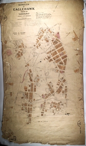
Map - PART OF THE BOROUGH OF EAGLEHAWK, 9/12/1902
... County of Bendigo..., County of Bendigo. Parish plan Canvas backed.... of Sandhurst County of Bendigo Map: Part of the Borough of Eaglehawk ...Map: Part of the Borough of Eaglehawk, Parish of Sandhurst, County of Bendigo. Parish plan Canvas backed.map, bendigo, city streets, borough of eaglehawk, parish of sandhurst, county of bendigo -
Bendigo Historical Society Inc.
Map - KANGAROO FLAT, 27/.01/1932
... county of Bendigo...Map: Township of Kangaroo Flat, Parish of Sandhurst, County... Bendigo township Kangaroo Flat Parish of Sandhurst county ...Map: Township of Kangaroo Flat, Parish of Sandhurst, County of Bendigo ( number 148 in Map Cupboard 1)map, bendigo, township, kangaroo flat, parish of sandhurst, county of bendigo -
Bendigo Historical Society Inc.
Map - KANGAROO FLAT SUBDIVISION, 26/11/1900
... County of Bendigo... of Sandhurst, County of Bendigo ( number 149 in Map Cupboard 1)... Bendigo parish plan Kangaroo Flat Parish of Sandhurst County ...Map: Plan of Subdivision at Kangaroo flat, Parish of Sandhurst, County of Bendigo ( number 149 in Map Cupboard 1)map, bendigo, parish plan, kangaroo flat, parish of sandhurst, county of bendigo -
Bendigo Historical Society Inc.
Map - NERRING, 15/06/1937
... County of Bendigo...Map: Parish of Nerring, County of Bendigo. Parish plan... Bendigo rural Nerring County of Bendigo Map: Parish of Nerring ...Map: Parish of Nerring, County of Bendigo. Parish plan Canvas backed ( number 139 in Map Cupboard 1)map, bendigo, rural, nerring, county of bendigo -
Bendigo Historical Society Inc.
Map - PARISH OF SANDHURST SHEET 5A, 1970
... County of Bendigo...Map: Parish of Sandhurst Sheet 5A, County of Bendigo... Bendigo parish plan parish of Sandhurst County of Bendigo Map ...Map: Parish of Sandhurst Sheet 5A, County of Bendigo. Parish plan ( number 161 in Map Cupboard 1)map, bendigo, parish plan, parish of sandhurst, county of bendigo -
Bendigo Historical Society Inc.
Map - BENDIGO IRRIGATION SETTLEMENT, 12/02/1908
... County of Bendigo... of Sandhurst and Wellsford, County of Bendigo ( number 160 in Map... Parishes of Sandhurst and Wellsford County of Bendigo Map: Plan ...Map: Plan of Bendigo Irrigation Settlement, Parishes of Sandhurst and Wellsford, County of Bendigo ( number 160 in Map Cupboard 1)map, bendigo, irrigation settlement, bendigo irrigation settlement, parishes of sandhurst and wellsford, county of bendigo -
Bendigo Historical Society Inc.
Map - BENDIGO, October 1st 1893
... County of Bendigo...Map: Plan of the whole County of Bendigo, Showing areas now... Bendigo lands for selection County of Bendigo Areas available ...Map: Plan of the whole County of Bendigo, Showing areas now available for Selection (number 340 in map cupboard 1)map, bendigo, lands for selection, county of bendigo, areas available for selection