Showing 169 items
matching dams and reservoirs
-
 Eltham District Historical Society Inc
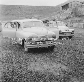
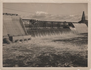
Album - Photograph, J.A. McDonald, Upper Yarra Dam, Oct. 1956
Upper Yarra Dam October 1956Record of various Shire of Eltham infrastructure works undertaken during the period of 1952-1962 involving bridge and road reconstruction projects, sometimes with Eltham Shire Council Project Reference numbers quoted. It was during this period that a number of significant improvements were made to roads and new bridges constructed within the shire that remain in place as of present day (2022). In many situations, the photos provide a tangible visible record of infrastructure that existed throughout the early days of the Shire. The album was put together by or under the direction of the Shire Engineer, J.A. McDonald.infrastructure, shire of eltham, bridge construction, road construction, 1956-10, upper yarra da, upper yarra reservoir -
 Eltham District Historical Society Inc
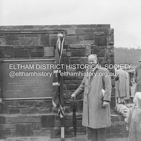
Negative - Photograph, J.A. McDonald, Upper Yarra Dam, 26 Nov. 1957
Sir Dallas Brooks following the formal opening of the Upper Yarra Reservoir, 26 November 1957 Upper Yarra Reservoir Opened by His Excellency The Governor of Victoria General Sir Dallas Brooks K.C.B.., K.C.M.G., K.C.V.O., D.S.O., K.St.J. On 26th November, 1957 This tablet also commemortyaes the centenary Of Melbourne's water supply system Yan Yean Reservoir 1857 Upper Yarra Reservoir 1957Record of various Shire of Eltham infrastructure works undertaken during the period of 1952-1962 involving bridge and road reconstruction projects, sometimes with Eltham Shire Council Project Reference numbers quoted. It was during this period that a number of significant improvements were made to roads and new bridges constructed within the shire that remain in place as of present day (2022). In many situations, the photos provide a tangible visible record of infrastructure that existed throughout the early days of the Shire. The album was put together by or under the direction of the Shire Engineer, J.A. McDonald.infrastructure, shire of eltham, 1957-11-26, opening ceremony, plaques, sir dallas brooks, upper yarra dam, upper yarra reservoir -
 Eltham District Historical Society Inc
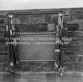
Negative - Photograph, J.A. McDonald, Upper Yarra Dam, 26 Nov. 1957
Upper Yarra Reservoir Opened by His Excellency The Governor of Victoria General Sir Dallas Brooks K.C.B.., K.C.M.G., K.C.V.O., D.S.O., K.St.J. On 26th November, 1957 This tablet also commemortyaes the centenary Of Melbourne's water supply system Yan Yean Reservoir 1857 Upper Yarra Reservoir 1957Record of various Shire of Eltham infrastructure works undertaken during the period of 1952-1962 involving bridge and road reconstruction projects, sometimes with Eltham Shire Council Project Reference numbers quoted. It was during this period that a number of significant improvements were made to roads and new bridges constructed within the shire that remain in place as of present day (2022). In many situations, the photos provide a tangible visible record of infrastructure that existed throughout the early days of the Shire. The album was put together by or under the direction of the Shire Engineer, J.A. McDonald.infrastructure, shire of eltham, 1957-11-26, opening ceremony, plaques, sir dallas brooks, upper yarra dam, upper yarra reservoir -
 Eltham District Historical Society Inc
Negative - Photograph, J.A. McDonald, Upper Yarra Dam, 26 Nov. 1957
Upper Yarra Reservoir Opened by His Excellency The Governor of Victoria General Sir Dallas Brooks K.C.B.., K.C.M.G., K.C.V.O., D.S.O., K.St.J. On 26th November, 1957 This tablet also commemortyaes the centenary Of Melbourne's water supply system Yan Yean Reservoir 1857 Upper Yarra Reservoir 1957Record of various Shire of Eltham infrastructure works undertaken during the period of 1952-1962 involving bridge and road reconstruction projects, sometimes with Eltham Shire Council Project Reference numbers quoted. It was during this period that a number of significant improvements were made to roads and new bridges constructed within the shire that remain in place as of present day (2022). In many situations, the photos provide a tangible visible record of infrastructure that existed throughout the early days of the Shire. The album was put together by or under the direction of the Shire Engineer, J.A. McDonald.infrastructure, shire of eltham, 1957-11-26, opening ceremony, plaques, upper yarra dam, upper yarra reservoir -
 Eltham District Historical Society Inc
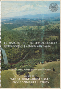
Book, Melbourne Metropolitan Board of Works, Lower Yarra Water Supply DeVelopment: Report on Yarra Brae-Sugarloaf Environmental Study, April 1974
environmental study, melbourne metropolitan board of works, report, sugarloaf reservoir, water catchment area, water supply, yarra brae dam, yarra river valley -
 Marysville & District Historical Society
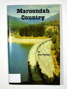
Book, Maroondah Country, 1979
A history of the Maroondah ReservoirPaperback. Front cover shows a colour photograph of the Maroondah Dam wall. Back cover shows a black and white photograph of the Maroondah Dam under construction.Madge Stevens / 85 Rose Street / West Coburg From Mena & Bill on / birthday 5.9.82 AN APPRECIATION Living all my earlier life at my birth-place, Heales-/ ville, with my sisters and brothers and our good parents,/ it was a privilege to return and re-acquaint during the/ collecting of these few impressions of the old times./ Thanks are due to the obliging attendants at MMBW/ and LaTrobe libraries, where frequent checks of old/ newspapers - including "The Healesville & Yarra Glen/ Guardian" - and records were essential./ Thanks also to my friends, and cousin Dave./ Ann Thomas Stamp of Marysville & District / Historical Society Inc / P.O. Box 22 / Marysville 3779maroondah dam, maroondah, fernshawe, healesville, maroondah aqueduct, maroondah reservoir, victoria, history -
 Eltham District Historical Society Inc
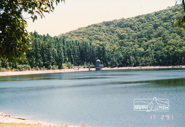
Photograph, Maroondah Reservoir, 17 Feb 1991, 17/02/1991
Colour photographmaroondah dam, maroondah aqueduct, maroondah reservoir -
 Kiewa Valley Historical Society
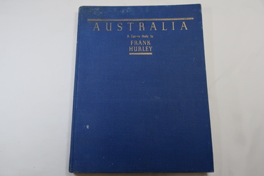
Book - Book- Photos, Australia - A Camera Study by / Frank / Hurley
Frank Hurley (1885-1962) was an Australian photographer and adventurer. He participated in trips to Antartica and was an official photographer with the Australian forces during both world wars. This book was first published in 1955.Photographs include the Hume Reservoir, Mt Buffalo and the Alpine High Country of Mt Kosciusko. (pages 140-144) All are associated with the type of country at each end of the Kiewa River. The Kiewa River flows into the Murray River just below the Hume Dam and Mt Buffalo and Mt Kosciusko are part of the Alpine High country near the Bogong High Plains. Clare Roper lived on a farm in the Kiewa Valley.Blue hard cover, bound book with the title in gold at the top. 208 pages. Mostly Black & white photos but some coloured.Inside back of first page - written 'Clare Roper'frank hurley photographer, australian photography, clare roper -
 Eltham District Historical Society Inc
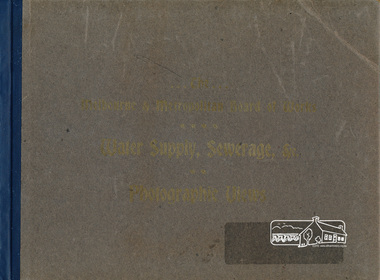
Book, The Melbourne & Metropolitan Board of Works Water Supply, Sewerage, etc. Photographic Views, 1908
... reservoirs ...In 1908 the Melbourne & Metropolitan board of Works published this book to illustrate its many constructions to provide Melbourne with its reticulated water and sewerage systems.This is now is a rare copy.Photographic images, landscape dimensions, hardboard cover, grey green colour Nilmmbw, weirs, dams & pumping stations, reservoirs, aqueducts -
 Glen Eira Historical Society
Document - Melbourne and Metropolitan Board of Works
This file contains five items relating to Caulfield Council Visits with the Melbourne & Metropolitan Board of Works (MMBW) from 1919 to circa 1974: 1/A photo album containing photos from the MMBW ‘visit to the Headworks, Yan Yean Water Supply, Wallaby and Silvery Creeks’ from 28/02/1919 to 03/03/1919, attended by members of the Caulfield City Council. The album contains 13 original black-and-white photographs, 3 of which are of the council members. The album is accompanied by a report by Felicitie Campbell, written 11/2008, about these visits. 2/A publication from the MMBW documenting its review of operations for 1973-1974. The report contains information about water supply, sewerage and drainage infrastructure completed or in progress during this period including infrastructure in Caulfield, Ormond, Carnegie and Bentleigh. 3/A periodical feature from the MMBW titled ‘Living City’, issue no. 16, Spring/Summer 1974. Included in the article titled ‘Program’ is a notice that construction will continue on the Elster Creek drain from Thomas St. to Wheatley Road, McKinnon. The periodical also includes the names of commissioners W. R. Walters from Caulfield and G. R. Bricker from Moorabbin (back cover). 4/2 maps and 1 information booklet from the Thomson Project Open Day attended by Felicite and John Campbell as representatives of the Caulfield City Council. This was an annual MMBW open date. Date unknown. 5/Resarch notes by Kate Aldred about the photo album and Thomson Project Open Day booklet and their links to Felicite Campbell 01/04./2014.koornang road, draper street, hall street, centre road, brewers road, caulfield intercepting sewer, byron street, caulfield park, elster creek, caulfield, carnegie, ormond, bentleigh, thomas street, brighton east, wheatley road, mckinnon, city of caulfield, bricker g. r., walters w. r., caulfield city council, melbourne and metropolitan board of works, hall councillor, murray councillor, murphy councillor, wharington councillor, phillips councillor, blyth councillor, best robert sir, reid doctor, jowett mr., wooley mr., hindle mr., annual reports, water supply structures and establishments, sewerage and sanitation, sewerage establishments, drainage, town planning, business and finance, councillors, mayors, acqueducts, dams and reservoirs, creeks, waterfalls, rivers, construction sites, north road, north road pumping station, cities and towns, campbell felicitie -
 Federation University Historical Collection
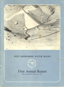
Book, Exchange Press Pty Ltd, West Moorabool Water Board First Annual Report For The Year Ended 30th June 1969, 1969
Documents the concept, construction and management of the Bungal dam built on the West Moorabool River in 1972 to safeguard the water supplies of Geelong and Ballarat. Provides details of the history, the West Morrabool Water Board and its members, the Act and finances.BookInk on paperlal lal, gordon, bungaree, wallace, lal lal, kerrit bareet, buninyong, bungal, lal lal reservoir, bungal dam, mt egerton, hopwoods hill, gordon, fiskens hill, green hill, mt buninyong, clarendon, r.g. biggs, w.f. stephen, r.a. horsfall, w.a. borthwick, t.m. conroy, sir henry bolte, west moorabool water board -
 Federation University Historical Collection
Map, Town of Buninyong, 1927, 09/1927
The date of this map is September 1927 revised from the original 1910 map. Buninyong was created a district on 09 July 1858, proclaimed a Shire on 16 February 1864, and the Buninyong Borough united on 01 October 1915.Township plan of the Town of Buninyong showing government roads and crown allotments. Earlier detail pencilled on (commercial buildings, etc) appears to be from an 1850 survey. Scale: 4 chains to 1 inch (1:3168)buninyong, map, buninyong botanical gardens, tannery dam, buninyong reservoir, chapel school, rev. hastie -
 Ballaarat Mechanics' Institute (BMI Ballarat)
Kirk's Reservoir
This photograph is from the Max Harris Collection held by the Ballaraat Mechanics' Institute. Please contact BMI for all print and usage inquiries.ballarat, kirk's dam -
 Bendigo Historical Society Inc.
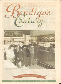
Newspaper - LONG GULLY HISTORY GROUP COLLECTION: BENDIGO'S CENTURY VOLUME SIX: 1950 - 1959
Newspaper supplement titled Bendigo's Century Volume six: 1950 - 1959. Front page has a photo of Gillies' famous corner, 1954. Each year has heading of Who's Who, Weather, Sport and Business. First year is 1950 titled Gillies: it's a Bendigo icon. 1951 is titled It's party time. 1952 - City mourns King George. 1953 - Mining ceases. 1954 - City thrilled at royal visit. 1955 - Push to save old Joss House. 1956 - Olympic fever grips Bendigo. 1957 - State Cabinet visits Bendigo. 1958 - Plan to keep historic mine. 1959 - Water storage woes solved. Back page has the Gillies Story.bendigo, history, long gully history group, the long gully history group - bendigo's century - volume six: 1950 - 1959, gillies' corner, bendigo advertiser, john lienhop mlc, north deborah mine, les gillies, alan gillies, norm gillies, black swan hotel, sir dallas brooks, cr a g weynton, bert mundy, cr poulston, the northern district school of nursing, lister house, the bendigo free library, rev dr c irving, shamrock hotel, sir albert dunstan, the most rev dr john mccarthy, jack davey, 1950 empire games, hercules gold mines, amy castles, ben templeton, cobb & co, cr norman oliver, reg parker, fred amer, les hammer, colonel george victor lansell, john quick, mr l w galvin, mr p j clarey mhr, hanro knitting mills, flooding, bendigo pottery, snow fall, the last lamp-lighter, the north deborah, aids & appliance shop, boardwalk, the late king george vi, the north deborah, beehive building, st paul's, st kilian's, upper reserve, bendigo trades hall, bendigo blackout, bendigo hospital, shamrock hotel, gerald smith, britannia hotel, mr a j harris, william morris (billy) hughes, andrew hampson, deborah anticline, north deborah, central deborah, diamond hill mine, north nell gynne mine, robert ross haverfield, sandhurst commercial courier, arthur moore lloyd, robert ross haverfield, angus mackay, jj casey, james henderson, david stuart, bendigo independent, colonel george lansell, bendigo base hospital, bendigo town hall, victorian electric traction association, the most rev b d stewart, st vincent's memorial college, commonwealth athletic club, south atlas racetrack, harp and shamrock hotel, mr and mrs f drake, cr f w clayton, cr r poulston, j h abbott & co, sir george lansell, clan macleod, bendigo gaol, queen alexandra fountain, belfast hotel, commonwealth bank, st vincent's college, lyric threatre, des duguid, brian cahill, lord's raceway, red white & blue extended gold mining company nl, central napoleon gold miningcompany nl, joss house, harry john, bendigo advertiser, mr leggatt, university of melbourne, anz bank, golden drive-in theatre, bank of australasia, john brown industries, bendigo football league, bendigo trotting club, faith leech, racv, bendigo sewereage authority, bendigo base hospital, bendigo benevolent asylum, henry bolte, jack davey, russell oakley, neville stilwell, channel seven, bendigo's olympic pool, annie caudle centre, strathfieldsaye aerodrome committee, southern airlines, cr d j osborn, cairn curran reservoir, state savings bank, commonwealth bank of australasia, belfast hotel, bennett's arcade, eppalock weir, bendigo cenotaph, sir edmund herring, cr a s craig, bendigo creche, bendigo high school, bendigo pottery, shamrock hotel, the venerable ronald richards, bishop riley, all saints cathedral, mr albert bush, bendigo arcade company ltd, woolworths, bull's head hotel, pike's corner, arcade hotel, upper coliban reservoir, cr tom flood, crystal egg co, sailor's guide, central deborah, central nell gwynne mine, bendigo benevolent home, ron masters, george daniel, eppalock dam, water commission, public works committee, bendigo central victoria telecasters ltd, channel nine, royal princess theatre, sir george lansell, volunteer defence corps, bendigo independent, countess erna cadorin, count ettore cadorin, ernst mueller, sutex pty ltd, dick turner, marco cavasassi -
 Melbourne Water
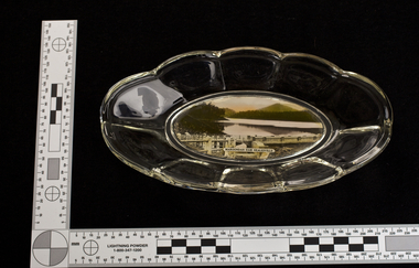
Glass Bowl, Maroondah Dam, Healesville Souvenir, 1930s -1940s
The Maroondah System was first and foremost developed as a functional component of Melbourne's Water Supply System. In addition to functionality, the Melbourne and Metropolitan Board of Works (MMBW) envisioned the Maroondah Reserve to be enjoyed aesthetically and recreationally by the public. This souvenir illustrates the realisation of the Maroondah System as a local recreational and tourist attraction in the early 20th century. The Maroondah Reserve gardens were landscaped with English-style ornamental stonework, exotic trees, flower beds and rose gardens. All features of the water supply system became widely celebrated as beauty spots that continue to be very popular to this day with tourists and locals alike. This souvenir is a product of that flourishing tourist trade. These water supply sites continue to enhance Melbourne’s charm and liveability and are now recognised as places of cultural and historic significance.This souvenir item has been curated by Melbourne Water as it represents an important historical aspect of the organisation by demonstrating the popularity of its water asset sites as recreational places and tourist attractions, and although these sites are functional parts of the water supply system, they were also designed to be enjoyed by the public both aesthetically and recreationally. Clear glass flower shaped 'depression ware' bowl with photograph of Maroondah Dam Healesville in the base.melbourne metropolitan board of works, mmbw, maroondah reservoir, melbourne water, scenic view, souvenir, glass, bowl -
 Melbourne Water
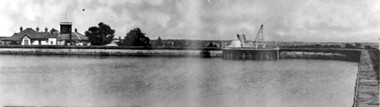
Photographs: The Maroondah Dam Wall Under Construction, 1921-1922
The Maroondah System was first and foremost developed as a functional component of Melbourne's Water Supply System. In addition to functionality, the Melbourne and Metropolitan Board of Works (MMBW) envisioned the Maroondah Reserve to be enjoyed aesthetically and recreationally by the public. This souvenir illustrates the realisation of the Maroondah System as a local recreational and tourist attraction in the early 20th century. The Maroondah Reserve gardens were landscaped with English-style ornamental stonework, exotic trees, flower beds and rose gardens. All features of the water supply system became widely celebrated as beauty spots that continue to be very popular to this day with tourists and locals alike. This souvenir is a product of that flourishing tourist trade. These water supply sites continue to enhance Melbourne’s charm and liveability and are now recognised as places of cultural and historic significanceThese photographs are invaluable in providing insight into many aspects of the Maroondah Reservoir’s early development. The dam wall is a distinctive example of early engineering techniques, with its gravity arch design and concrete construction. The construction of the dam wall represents an important advancement in the technology of dam-building.These images are part of a series of eight photographs which document the construction of the Maroondah Dam in the 1920s.melbourne metropolitan board of works, mmbw, melbourne water, photograph, water, maroondah dam, construction, wall -
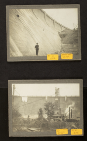
Tatura Irrigation & Wartime Camps Museum
Photograph, Big Eildon Project, 1954
Taken by photographer for State Rivers and Water Supply Commission.Large sepia photograph. Terraced earthen bank forming wall of reservoir main feature - trees and several telegraph poles in foreground - gently rounded hills on horizon.Below photo: "BIG EILDON PROJECT / MAIN BANK FROM OBSERVATION POINT."victoria state rivers and water supply commission, eildon, eildon dam -
 Whitehorse Historical Society Inc.
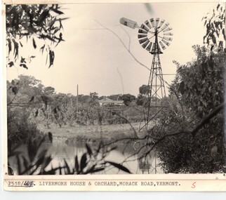
Photograph, Dam and windmill on Livermore Orchard in Vermont
Black & white photo of dam and windmill at Doug Livermore's Orchard in Vermont. (see also NP500)Black & white photo of dam and windmill at Doug Livermore's Orchard in Vermont. (see also NP500)orchards, livermores orchard, dams and reservoirs -
 Whitehorse Historical Society Inc.
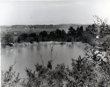
Photograph, Dam on Clem Livermore's property in Morack Road
Black & white Photo of the dam on Clem Livermores Property in Morack Road, Vermontlivermore clem, dams and reservoirs, morack road, vermont -
 Rutherglen Historical Society
Image, c 1930
Black and white photograph of the Hume Weir under construction.On back of photo: "Hume Weir" and an oval rubber stamp "V. Peterson | Photographer | Hume Reservoir"hume dam, hume weir, hume reservoir, lake hume, dam construction -
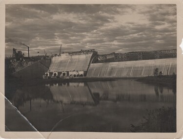 Rutherglen Historical Society
Image, c 1930
Black and white photograph of the Hume Weir under construction.On back of photo: "Hume Weir" and an oval rubber stamp "V. Peterson | Photographer | Hume Reservoir"hume dam, hume weir, hume reservoir, lake hume, dam construction -
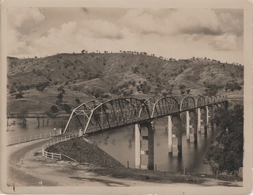 Rutherglen Historical Society
Image, c 1930
Black and white photograph of the Bethanga Bridge with hills in the background.On back of photo: "Hume Weir" and an oval rubber stamp "V. Peterson | Photographer | Hume Reservoir"hume dam, hume weir, hume reservoir, lake hume, bethanga bridge -
Unions Ballarat
WJ McAdam: "Labor Memoirs, Ballarat", William J McAdam, circa 1960s
W.J. McAdam was a former union organiser (Ballarat Municipal Employees section of the Shop Assistants and Textile Workers Union). He is a past president and secretary (on two occasions) of Trades Hall, Ballarat. "Labor Memoirs, Ballarat": #Ballarat North Railway Workshops History #Preferential voting at elections #History of the White Swan Dam Project (1 vol) The White Swan Dam was completed in the 1950s. Ballarat North Railway Workshops were opened in 1917 after political pressure to decentralise railway workshops. The White Swan Dam was completed in the 1950s. Ballarat North Railway Workshops were opened in 1917 after political pressure to decentralise railway workshops. Relevant to Ballarat employment opportunities, history of preferential voting and history of the White Swan Dam Project. 2017 is the centenary of this important outcome for the City of Ballarat. Paper (1 volume) btlc, ballarat trades hall, ballarat trades and labour council, wj mcadam, labor memoirs, preferential voting, elections, white swan dam project, textiles, textile, clothing and footwear union, white swan reservoir, railways, voting, ballarat north railway workshops -
 Ballarat Heritage Services
digital photographs, Lisa Gervasoni, Pre-Olympic Swimming Pool at Kilmore, c2012, c2010-2017
There are many reports of early swimming holes in 19th Century Victoria. Between the period 1895 - 1920, most rural Councils were under pressure to provide more formalised bathing arrangements. Often this occurred through the building of wooden enclosures in rivers, the damming of creeks, the construction of lakes, or the utilisation of old pits for the purpose.Colour photograph of the site of the former Kilmore Pool, now a reservoir on the Kilmore Golf Club. swimming pool, sport, swimming, pre olympic, natural, lake, kilmore, pre-olympic -
 Ballarat Heritage Services
Photograph - Digital photograph, Lisa Gervasoni, Upper Coliban Reservoir, 2017
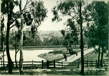
Constructed in 1903 and enlarged in 1917 this dam originally featured the only siphonic spillway in Victoria. Being the uppermost of the three Coliban storages, it is usually the first drawn down in periods of high demand.Colour photograph of the Upper Coliban Reservoir.upper coliban, coliban, water, reservoir, supply, system, upper coliban reservoir, water storage -
 Southern Sherbrooke Historical Society Inc.
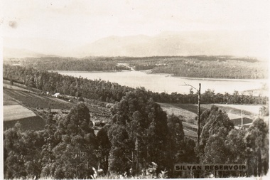
Postcard, Silvan Reservoir
Sepia-toned postcard featuring distant view of Silvan Dam. The middle ground shows cleared land all set out for agriculture, houses also visible. c. early 1930s -
 Southern Sherbrooke Historical Society Inc.
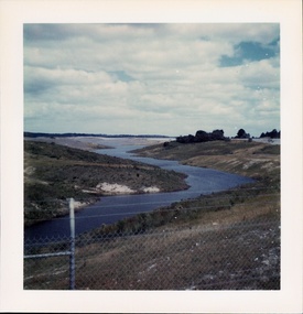
Photograph - Cardinia Reservoir filling, post 1973, Narre Warren East area
A set of five colour photos showing Cardinia Dam beginning to fill after its completion in 1973. One photo shows smoke or possibly dust rising on a distant hillside. The set was donated to the society by David Howe. -
 Bendigo Historical Society Inc.
Document - PETER ELLIS COLLECTION: A GUIDE FOR DRIVERS ON THE WHIPSTICK TOUR
A Guide for Drivers on the Whipstick Tour. First page gives assembly area, driving in convoy and negotiating water or boggy patches across the road. Amended written at the end of the page. Directions with mileage and items of interest for the tour on Sunday September 9th (no year). A Whipstick Map 1971 showing State Forest, Crown Lands, Uncleared Mallee - Private (shown in different colours) Water Reserve and Roads. Noted are Flora and Fauna - Plants, Birds & Mammals, and areas of State Forest and Southern State Forest with Mallee Scrub area noted. Also State Forest & Crown Lands Total Area and a map scale. The Bendigo Whipstick mentions area, suggestions of where the name Whipstick came from, shrubs and flowers with their flowering times, descriptions of some of them and some information on the Mallee Fowl. The Eucalyptus Oil Industry paragraph mentions the beginnings of the industry. Mentioned are the different uses of oils (perfumery, industrial and medicinal) and the different species of eucalypt used for each and various products. Also notes on the growing, harvesting and refining of eucalyptus. P Ellis at the end of the page. The next two and a half pages mentions reserves, and at the end acknowledgements. Includes a spare copy of 'The Bendigo Whipstick' by P Ellis.bendigo, history, early bendigo, peter ellis collection, a guide for drivers on the whipstick tour, the whipstick 1971 map, shire of marong, shire of east loddon, shire of huntly, borough of eaglehawk, city of bendigo, shire of strathfieldsaye, the bendigo whipstick, eucalyptus oil industry, eaglehawk town hall, lightning hill lookout, eaglehawk rifle range, new moon mines, blue jacket reservoir, maggetti's wine hall, camp hotel (ex), skylark dam, eucalyptus oil production, eucalyptus factory, whipstick eucalyptus farm, ruedin's eucalyptus factory, dutch bowls, governor philip, sir joseph banks, john white, baron von mueller, joseph bosisto, commonwealth government, perfumery oils, industrial oils, medicinal oils, p ellis, dr frith, csiro wildlife division, harley webster, forests commission, vincent serventy, victorian national parks association, bendigo field naturalists club -
 Surrey Hills Historical Society Collection
Photograph, Surrey Hills Reservoir No 1
Copied by Ken Hall from an early postcard. This is Surrey Hills Reservoir No 1 on the corner of Tower Street built in c1892 at a cost of £12,000 to supply higher sections of the area. The builders were Jack and Bob Laudehr, partners in a wood yard in St. Kilda (Vic). They began by delivering firewood but extended to contract work involving timber. Another of their projects was to lay cable tram tracks commencing in Acland Street St. Kilda and running along The Esplanade. The reservoir in Canterbury Road was a large concrete structure built before the introduction of reinforcements. The excavated material was banked against the sides and pine trees were planted in it to add strength to the embankment. They were paid £2,000 for their work. Construction of Surrey Hills Number 2 Reservoir was completed in 1913 and the accompanying tower was built in 1929. It is assumed that the Miss Hill as the source of the donation (via Bill Dempsey) was Ivy Annie Hill (1902-1984). She was the only female child of William Valentine Dempsey to not marry. Bill Dempsey's mother was Laura Constance 'Birdie' Hill (1900-1968) who married Albert Dempsey.A sepia photograph within a post card of a reservoir on Canterbury Road, Surrey Hills. In the background to the left you can see the top halves of two houses and the tops of some trees. The photo takes up only the central section of the postcard.Below the photo on the front of the postcard on blue biro "Reservor [sic] Canterbury Rd / Surrey Hills." On the rear in grey lead pencil in Jocelyn Hall's handwriting: "Donor W Dempsey ------------- Keep / (nephew) / [arrow pointing down] / From Miss Hill / 10 Pembroke St SH / This house can be / seen in front of / No 12 which has / tower"1890, water supply, mmbw, edward d dyer (mr), 10 pembroke street, 12 pembroke street, surrey hills, ivy annie hill (miss), william valentine hill (mr), canterbury road, tower street, water supply structures and establishments, dams and reservoirs, jack laudehr (mr), bob laudehr (mr) -
 Wodonga & District Historical Society Inc
Album - Hume Reservoir Australia Album - Plans and Progress Photos - River Murray Water Scheme, Department of Public Works, N.S.W, 1927
This set of photos is from a leather bound album bearing the inscription "HUME RESERVOIR AUSTRALIA" plus 'The Rt. Hon. L. C. M. S. Amery, P. C., M .P.' all inscribed in gold. It was presented to The Rt. Hon. L. C. M. S. Amery, P. C., M. P, Secretary of State for Dominion Affairs on the occasion of his visit to the Hume Reservoir on 2nd November 1927. This album is of local and national significance as it documents the planning and development of the Hume Reservoir up to 1927. It was the largest water reservoir in the British Empire. The album records the pioneering engineering work that went into its construction.1. Locality Plan and Plan of Dam. The dam is about ten miles by road upstream from Albury and about three-quarters of a mile below the confluence of the Mitta Mitta River and the Murray River. Its main features consist of a concrete portion across the bed of the river with earth embankment at both ends. The foundations throughout are on hard granite, found at an average depth of about 40 feet below the surface, the centre line being located to take advantage of the most favourable rock levels.Heading on page "WORKS UNDER RIVER MURRAY WATERS AGREEMENT/HUME RESERVOIR" Beneath top diagram "FIG. 1. ELEVATION" Beneath second diagram "FIG. 2. PLAN" On map "LOCALITY PLAN"hume reservoir australia, river murray waters scheme, hume weir diagrams, hume weir location