Showing 126 items
matching elsternwick park
-
 Melbourne Tram Museum
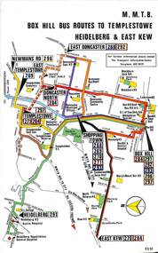
Map, Melbourne & Metropolitan Tramways Board (MMTB), Set of 8 bus route maps, 1977 to 1979
... Point Ormond Elsternwick Footscray Sunshine Deer Park North ...Series of colour route maps for various bus or groups of tram lines for the MMTB. Some have the Transport Information Centre telephone printed on them, others have a label stuck on. Some are finished with a plastic laminate finish on either one or both sides. Show the major cross streets, parks, schools, other tram routes, major stop numbers and railway lines. .1 - Box Hill bus routes to Templestowe - R38/82, Heidelberg and East Kew, includes Doncaster, Shoppingtown and Newmans Road. .2 - Clifton Hill - R2/79 - Elsternwick, Point Ormond and St Kilda Junction .3 - Footscray, Sunshine, Deer Park, Nth Altona, Fishermen's Bend, Highpoint and Williamstown Road - R2/79. .4 - Bulleen - City - Port Melbourne - Garden City Bus Route, including Kew, Collingwood - R6/78 .5 - City - Warrandyte and East Doncaster including Newmans Road, Templestowe, East Doncaster, Donvale, Shopping town, and Kew. R3/82. .6 - West Heidelberg, La Trobe University, Northland - R3/81 .7 - Box Hill, Ringwood to East Doncaster and Warrandyte, Park Orchards, North Blackburn R3/82. .8 - Geelong - Herne Hill, Rollins Road, Donnybrook Rd, North Shore and Corio Villagetrams, tramways, maps, route guide, route numbers, routes, buses, box hill, templestowe, doncaster, east kew, heidelberg, clifton hill, point ormond, elsternwick, footscray, sunshine, deer park, north altona, fishermen's bend, highpoint, williamstown rd, bulleen, kew, collingwood, port melbourne, garden city, warrandyte, donvale, la trobe university, northland, ringwood, park orchards, mitcham, blackburn, geelong -
 Melbourne Tram Museum
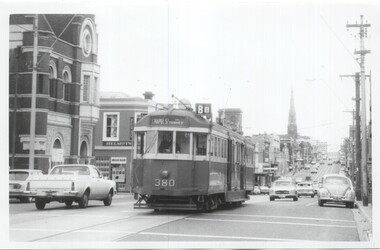
Photograph - Set of 4 Black & White Photograph/s, Clive Gibson?, c1975
Set of four Black and White photographs of W2 380. Photos not dated, c1975. .1 - Toorak Road, just past Osborne St, South Yarra, with the South Yarra Post Office in the view. Also Helmuts Milk Bar? Tram has the destination of Chapel St, route 8B. .2 - Turning from Park St South Yarra into Toorak Road. Tram has the destination of Toorak, route 8. Note the Bundy clock on the left hand pole. .3 - In St Kilda Road, at the Arts Centre, with destination of Elsternwick, Route 4E. .4 - turning from Toorak Road into Park St, route 8. See image i5 for envelope which has the names of Clive Gibson, Dave Menzies and date 1975 which could be the date the photos were sent to Dave Menzies for some reason.trams, tramways, w2 class, bundy clock, route 8b, toorak road, south yarra, park st, route 8, st kilda rd, route 4e, elsternwick, tram 380 -
 Melbourne Tram Museum
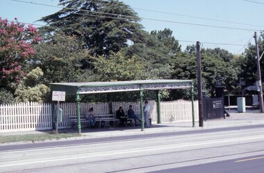
Slide - Set of 17 - Tramway Shelters, Robert Green, c1990
Set of 17 colour slides of tramway shelters, poles, and substations by Robert Green c1990. Shelters by the PMTT, HTT and MMTB 1 Tramway Shelter (PMTT) - Cnr Balaclava and Orrong Road, Caulfield 2 - ditto 3 - Tramway Shelter (PMTT) - Cnr. Cotham Road and Burke Road, Deepdene 4 - Tramway Shelter (PMTT) - Cnr. Cotham Road and Burke Road, Deepdene with telephone box alongside. 5 - Cnr. Malvern Rd and Orrong Road, Toorak 6 - Cnr. Malvern Rd and Orrong Road, Toorak 7 - Cnr. Dandenong Road and Hawthorn Road, Caufield 8 - ditto 9 - PMTT Substation - Rusden Street, Elsternwick 10 - PMTT poles cnr. Dandenong Road and Wattletree Road 11 - Tram shelter (HTT) Riversdale Road and Highfield Road - Camberwell - Highfield Park 12 - Tram shelter (HTT) Riversdale Road and Wattlevalley Road, Camberwell 13 - ditto 14 - Tram shelter (HTT) Camberwell Road, cnr Bowen St. Camberwell. 15 - Tram Shelter (HTT) Camberwell Depot, Riversdale Road, Hawthorn 16 - Merri Creek Bridge, St. Georges Road, North Fitzroy 17 - Merri Creek Bridge, St. Georges Road, North Fitzroy - foundation stone Yields information about Melbourne's tramway stop shelters and other infrastructure.Set of 17 Kodak colour slides in plastic mounts.tramways, shelters, caufield, deepdene, toorak, orrong road, cotham road, balaclava road, pmtt, htt, mmtb, riversdale road, camberwell depot, merri creek bridge, foundation stone, dandenong road, poles, rusden st, substations, hawthorn road, st.georges road -
 Melbourne Tram Museum
Map, Melbourne & Metropolitan Tramways Board (MMTB), MMTB Route Maps, 1979
Series of colour maps for various tram and bus routes, dated 1979. Also contained, not scanned are letters, reports, and specifications for printing these maps for use in shelters etc. Some have the Transport Information Centre telephone printed on them. Some are finished with a plastic laminate finish on either one or both sides. Show the major cross streets, parks, schools, other tram routes, major stop numbers, and railway lines. See also item 3909 for another example of these. Trams 1 - City route guide - R9/77 - showing all route numbers and destinations that passed through the CBD. 2 - Bourke St tram routes - R4/77 - East Brunswick Blyth St and East Preston Tyler St and intermediate routes, routes 95, 96, 97, 90, 89 and 88. 3 - Malvern, East Malvern, Carnegie, and East Brighton Tram Routes (from St Kilda Junction) - R1/79 - shows routes 5, 3, 67, 66, 61, 62, and 64. 4 - Elizabeth St tram routes - R12/77 - Essendon Airport, West Maribyrnong, North Coburg lines, routes 50, 58, 60, 54, 57, 52. 49, 59, 18, 20 and 19 5 - Flinders St tram routes - R5/78 - North Balwyn, East Burwood, routes 48, 40, 41, Hartwell, 28, 74 and 75 6 - Kew - St Kilda Beach - R1/79 - Route 69. 7 - Mont - Albert City - R11/77, shows routes 43. 47. 45. 44 8 - St Kilda Rd Tram Routes R12/77 - details South Melbourne Beach, route 1 and route 2 and St Kilda Beach routes 15, 16, and 55 otherwise shows where the various routes branch off St Kilda Road 9 - Batman Ave tram routes - R9/77 - Wattle Park, North Richmond and Prahran - routes 70, 71, 78 and 79. 10 - Footscray - Moonee Ponds - R3/81 - Route 82 11 - Swanston St tram guide - R1/79 - lists all routes and route numbers that branch or cross Swanston St between Grattan St and St Kilda Junction. 12 - Toorak Camberwell and Glen Iris tram route with Camberwell Junction and Malvern Town Hall, R1/79, routes 8, 7, 6, 72, and 73 shown. 13 - West Preston - Beach tram routes - R12/77 - routes 10, 11, 9 and 12, 14 - William St tram routes - R12/77 - Route 55, 56, and 63 - South Melbourne Depot and Domain. Buses 1 - Footscray, Sunshine, Deer Park, Nth Altona & Fishermans Bend - R2/79 2 - Box Hill bus routes to Templestowe, Heidelberg & East Kew - R6/78 - notes superseded by R3/82 3 - Plan of Russell St Melbourne bus departure bays. 4 - Box Hill, Mitcham & Ringwood bus routes to East Doncaster & Warrandyte - R3/82 5 - City - Warrandyte & East Doncaster bus routes - R3/82 & R6/78 6 - Bulleen - City - Port Melbourne - Garden City Bus route - R6/78 7 - North Altona - City bus route - 11/78 8 - Clifton Hill - Elsternwick - R2/79 9 - La Trobe - Northland - West Heidelberg - City Bus Service via East Freeway - 11/79 and R3/81 10 - Box Hill, Mitcham & Ringwood Bus Routes to East Doncaster & Warrandyte - R10/84 - with the Metropolitan Transit logo.Yields information about tram and bus routes in late 1970s early 1980s.Book - brown comb binding, card and clear plastic covers containing both bound and unbound maps and documents.K C Painter on front cover in ink.tramways, mmtb, tram routes, maps, bus routes, route numbers, routes, route guide -
 Glen Eira Historical Society
Document - TOURS
There are two copies of the Discover Caulfield guide produced by the Caulfield Historical Society. One from 1982 which contains twelve pages, seven of which are typed and the last five a continuation of the guide added later, hand-written. The other is a modern typed version of the same document, including information at the end that "Notes prepared by R. Ballantyne, 25th July, 1982, updated by Betty Snowball, 1992 and Gladys Vallati 4th August, 1995". They both detail a pictorial tours of the mansions and gardens in the City of Caulfield, similar but not identical.caulfield, mansions, gardens, homes, ‘lirrewa’, lirrewa grove, caulfield city hall, smith sydney, ‘halstead’, bambra road, halstead road, caulfield historical society, messrs. upton and smith, civic establishments, dickson james dr., houses, national trust, st. stephen’s church, balaclava road, gothic (revival) architecture, messrs. haddon and henderson, st. aloysius, archbishop of melbourne mannix dr., caulfield park, hawthorn road, inkerman road, kambrook road, paddy’s swamp, cannizzo philip, caulfield city council, trams, orrong road, grimwade house, ‘harleston’, grimwade frederick sheppard, primary schools, caulfield art centre, ‘stanmark’, art galleries, ‘craigellachie’, person william, pearson eliza, francis newton mr., greenmeadows gardens, milburn grove, greenmeadows house, lempriere john, mayors, ‘glenfern’, boyd john captain, boyd martin, ‘myoora’, alma road, ‘bagatelle’, christian thomas, henderson anketell, flats, building construction, ‘burreel’, kooyong road, burreel avenue, francis john, stephen sidney, allan george l., ‘royston’, renwick s. mrs., sargood frederick sir., ‘glen eira’, ricketson henry, caulfield hospital, royal southern memorial hospital, caulfield general medical centre, ‘ripponlea’, reed and barnes, architects, towers, rippon emma, rippon thomas, guilfoyle william, employees, ‘the village houses’, regent street, st. george’s road, cottages, bent thomas sir., jones louisa mrs., nathan benjamin, ‘anselm’, glenferrie street, queen anne style, haddon robert, historical buildings, princes’ park, ‘glenmore’, watts thomas, more hugh, glenhuntly road, gates, villas, ‘hopetoun’, hopetoun street, webb charles, hopetoun hospital, harleston park, allison street, langdon montague, langdon harry joseph, ‘tarqua’, ‘labassa’, manor grove, koch john, robertson a. w., wagner john, ‘ontario’, trinity congregational church, grange road, glen huntly, churches, greek orthodox church, ‘fairfield hall’, north road, younger james, glenhuntly post office, smith alfred, smith anne, methodist church, ‘lambros the cobbler’, railways, ballantyne r., snowball betty, kahlyn private hospital, ‘kynaston’, st. mary’s jubilee school, festivals and celebrations, st. mary’s anglican church, church of england, bishop moorhouse, joynt donoman, elsternwick post office, elsternwick, elsternwick bowling club, elsternwick rsl, caulfield grammar school, davis henry rev., selwyn street, elsternwick railway station, glen eira road, barnett r. j. rev., tudor court, world war 1914-1918, ‘fairhaven’, hope george, caulfield library, plaques, cannons, ‘janvec joinery’, parkside street, ‘parkside court’, clarence street, ‘streetscene’, grange road, greenhouses, vallati gladys -
 Glen Eira Historical Society
Album - Page 13 of folder D-F, Caulfield Municipality Photo Slide Collection, c.1976 - c.1994
The photographs for the slides are believed to have been taken by the inaugural Editor for the Caulfield Contact - the official newspaper of the former City of Caulfield from 1976-1994. The Editor was also Council's Community Liaison Officer and she (and her successor) took many photographs of official events and Council-related services and locations in connection with both these official roles. The City of Caulfield was the Municipal Council for an area of the South Eastern suburbs of Melbourne, including Brighton East, Carnegie, Caulfield, Elsternwick, Gardenvale, Glen Huntly, McKinnon, Murrumbeena, Ormond and St Kilda East. Credit: Glen Eira Historical Society - This item was digitised and made available through the Glen Eira Heritage Digitisation Strategy 2019-2023. Glen Eira Historical Society acknowledges the support of Glen Eira City Council. Page 13 of slide album D to F, in a polypropylene slide sleeve containing 12 x 35mm colour slides. A sample of 2 images from this page is included. glen eira city council, local government, caulfield city council, caulfield council, city of caulfield, caulfield contact, elsternwick, caulfield municipality photo slide collection, roads and streets, parking, shops, downshire road, glenhuntly road, trams, hopetoun gardens, parks and reserves, cannons