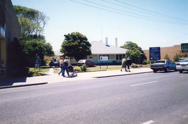
Showing 640 items
matching footpaths
-
 Canterbury History Group
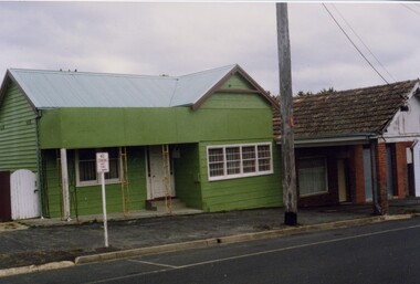
Photograph - Highfield Timber and Hardware Coy., Highfield Road, Canterbury, c.1970
Coloured photograph of Di Lederman , daughter of Henry Lederman, on the footpath outside the Highfield Timber and Hardware Coy. at 69a, 69 and 71 Highfield Road Canterbury. c. 1970canterbury, highfield timber and hardware coy, highfield road, timber yards, lederman> henry, lederman> di -
 Lakes Entrance Historical Society
Photograph - Historic House, Holding M, 2005c
Built in 1923/24 for Mr Eric Staughton, originally named Greenacres, later Livingstone House in 1950 when purchased by Hallett Sisters. In 1996c became temporary office for East Gippsland Shire.Colour photograph of a weatherboard house situated at 545 Esplanade, showing cars parked on lawn, four people on footpath, side of Strambi Hair Salon. Lakes Entrance Victoriatownship, people, local history, houses -
 Eltham District Historical Society Inc
Photograph, Footpath tripping hazards, Shire of Eltham review
... footpaths ...Roll of 35mm colour negative film, 3 stripsKodak GA 100 5095shire of eltham, roads, footpaths -
 Eltham District Historical Society Inc
Photograph, Were Street, Montmorency
Local stories told by school children and interpreted by artists in the footpath. This one is about a cow that used to come and eat Blanche Shallard's dahliasColour photographblanche shallard, montmorency, were street -
Port Melbourne Historical & Preservation Society
Photograph - Extensions to Port Melbourne Bowling Club, Pat Grainger, c. 2000
Port Melbourne Bowling Club was extended over the footpath and the latter recreated in order to be able to accept women into the Club (extension is for ladies' facilities)Colour photograph showing the extensions to the Port Melbourne Bowling Club building at the Nott Street end c2000sport - lawn bowls, built environment - recreational facilities, port melbourne bowling club -
 Ringwood and District Historical Society
Photograph, Entrance to Ringwood Railway Station - 1939
Black and white photographs (3 copies- 2 large, 1 smaller) Typed above one photograph: "Entrance to Ringwood Railway Station - 1939". Image shows some shops either side of station entrance with some men standing on footpath and road.Station in background with cars parked in front. -
 Whitehorse Historical Society Inc.
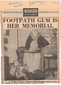
Newspaper - Article, Footpath gum is her memorial, 4/07/1974
The death of Mitcham identity Katherine Fielding Barnsley who died on 9th July at the age of 92. Many people in Mitcham will remember her as the lady who succeeded in a lone fight against the Council over the footpath in Lucknow Street, also as a breeder of champion whippets, one of Britains leading authorities of the breed. Outside her home still stands the gum tree for which she fought and around which the footpath loops..barnsley, katherine fielding, memorial gum tree, lucknow street mitcham -
Lakes Entrance Historical Society
Photograph, M O Fish, 1948 c
May men in photograph are wearing service medals. Brodribbs Garage in background and Searls Dry Cleaners next to itBlack and white photograph of a march being assembled on corner of Main and Service Streets. A long line extends along footpath in front of shops and across Main Street Bairnsdale Victoriasports, festival, competitions -
 Stawell Historical Society Inc
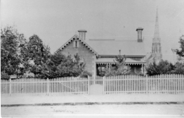
Photograph, Anglican Vicarage in Main Street Stawell
Brick Anglican Vicarage in Main Street purchased 1923 surrounded by trees and with picket fence and gate. In 1923 the house on the west side of the Church was purchased to be the Vicarage, the former Vicarage in Stawell West being sold. In this same year electricity was connected to the Church, the Hall and the Vicarage. The organ which had been hand pumped till then was fitted with and electric blower. This photo is a copy off a loaned postcard. The dwelling was purchased by the Anglican Church 1923, the former vicarage in Seaby Street being sold. The Spire in the background is St. Matthews Presbyterian Church. The vicarage is now demolished and replaced by a new building.Black & White photograph of a scene depicting a brick dwelling with veranda right hand side and a church spire in the background. Trees surrounding the building. A picket fence with gate and footpath in foreground.stawell religion church -
 Mt Dandenong & District Historical Society Inc.
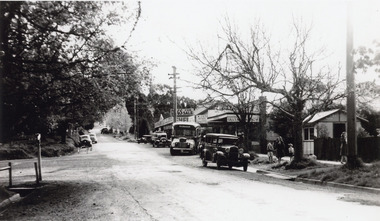
Photograph, Olinda Township c1950, c1950
Scene in Olinda township looking up towards range Road. Cars and busses parked along roadside and women and children on footpath. General Store and Gills Newsagency on LHS. c1950.olinda, gills newsagency -
 Tarnagulla History Archive
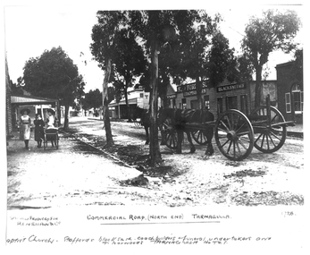
Photograph of the north end of Commercial Road, Tarnagulla, North end of Commercial Road, Tarnagulla, c. 1909
Murray Comrie Collection. This photograph shows business on the north end of Commercial Road, Tarnagulla. From right: the brick Baptist Church (now private residence), Stafford's Blacksmith Coachbuilders and funeral/undertakers (since demolished), & Norwood's Tarnagulla Hotel. Information collated by Murray Comrie: Stafford's premises were built on land previously occupied by the stables of the George Hotel. The Stafford's building was later taken over and run by Frank McNamee. This photograph is a dark copy created from an older original. Copy probably made by Murray Comrie in the 1970s. Monochrome photograph depicting the north end of Commercial Road, Tarnagulla. A large wagon with team of horses is standing in the road. Three girls are walking down footpath at left side of image.Written on the original: 'Specially produced for Renshaw & Co' and 'Commercial Road (North End) Tarnagulla'. Written on this copy: 'Baptist Church Staffords Blacksmith Coachbuilders and funeral/undertakers, & Norwood's Tarnagulla Hotel'.tarnagulla, commerce, industry, blacksmithing, smithing, coachbuilding, businesses, stafford, norwood, mcnamee, buildings, hotels, churches, commercial road, main street -
Canterbury History Group
Photograph - Photograph of the bronze plaque and contents of the time capsule to be positioned under the footpath outside No. 78 Maling Road, Canterbury, Jan Pigot, 1994
Coloured photograph of the bronze plaque and contents of the time capsule to be positioned under the footpath outside No. 78 Maling Road, Canterbury on 21st May 1994, to be opened on the same day in 2044.canterbury, maling road, shops, signs, plaques, time capsule -
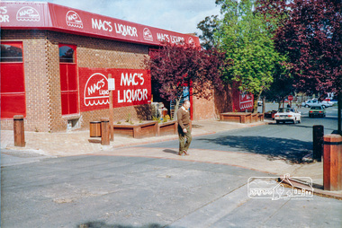 Eltham District Historical Society Inc
Photograph, Pedestrian access upgrade, Pryor Street, Eltham, c. Oct 1987
Looking down Pryor Street towards the intersection with Main Road, Mac's Liquor on left. Shows upgraded footpath area with new paving and planter boxesColour photographeltham, main road, shire of eltham, infrastructure development -
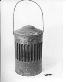 Whitehorse Historical Society Inc.
Functional object - Lamp
Lamp used to warn of dangerous area or objects on road, footpath or railway gates owned by Council or the Railways. This one belonged to the Country Roads Board of Victoria.Red painted outer case with lid. Inner red glass lamp and kerosene holder with wire to lift out for filling. Gaps all round to allow light to shine out and to let air in to allow lamp to burn. Country Roads owned.lighting, kerosene & oil -
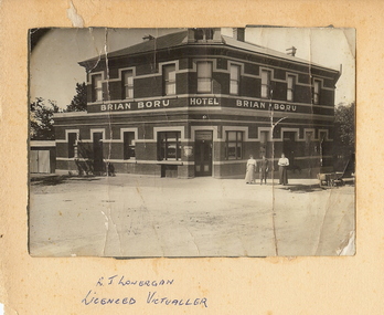 Bendigo Historical Society Inc.
Photograph - BRIAN BORU HOTEL: BENDIGO, approx. 1900
Black and white photo of Brian Boru Hotel, Bendigo with three women standing on footpath. Photograph placed off centre of cardboard. On front of photo handwritten ' R.J. Lonergan, licenced victualler'.organization, business, brian boru hotel -
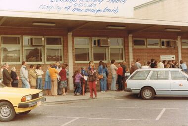 Bendigo Historical Society Inc.
Photograph - JORDAN COLLECTION: BENDIGO RAILWAY STATION, 25th July 1982
Colour photo of the front of the Bendigo railway Station, 25 July 1982, for the display of the orange train. Numerous people have lined up along the footpath, and there are 2 cars in the parking area.bendigo, tourism, railway station -
 Linton and District Historical Society Inc
Photograph, Buildings, Sussex Street, Linton, 1988
Photograph taken in 1988 of buildings in Sussex Street, Linton: house was previously Bill and Georgie Hall residence and before that a cake shop run by Stella Ralf (Stella Ralf also taught piano). Next to it can be seen the former Bennett garage building. Bennett shop and garage (petrol station) 1920s-1940s. Later (1970s-1981) run as op-shop by Mrs. Surman to raise money for Maxwell Park C.E.B.S. camp. House had a later incarnation as a laundromat in 1980s - at this time many women were still without electricity on outlying farms and house blocks.Colour photograph showing green painted timber house with pitched roof and small verandah, white trim, next to brick building with pitched roof and verandah over footpath, brick pillars. "Stella Ralph's old shop (cake) later Bennett garage"stella ralf, bennett's garage, stella surman, bill hall, georgina hall -
 Vision Australia
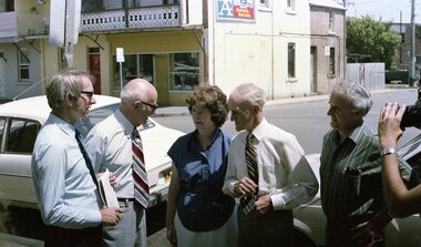
Photograph - Image, Royal Blind Society of New South Wales street images, 1982
Two images of a group of people standing on a footpath and being interviewed. The central point are two men and a woman, with the television camera pointed towards them in both shots.2 negatives on strip under heading 'Christmas Party 1982'royal blind society of new south wales, marketing -
 Eltham District Historical Society Inc
Photograph, Public toilets, Were Street, Montmorency, c.1990
Photographs of public land in Were Street, Montmorency with public toilets. Before the the erection of the wind mill. Brick paved footpath, angle parking and two public phone boxes.6 colour photographs (2 sets)montmorency, public tiolets, were street, parks, public toilets, shopping centres -
Phillip Island and District Historical Society Inc.
Photograph, circa 1930
The Esplanade looking towards "The Continental" from Thompson Avenue.Early model cars parked and travelling bottom left to top. Middle right made footpath with men and women pedestrians. Fences and hedges along right top to bottom Gas lights in foreground.The Esplanade, Cowes No 72local history, photography, photographs, slides, film, street scape, black & white photograph, street scapes 1930s -
Glenelg Shire Council Cultural Collection
Photograph - Contact Print of Portland scenes, 1960-1970
Black and white contact sheet. Image shows front view of steam train on Portland line, parallel to Bentinck Street and footpath leading down to beach and baths. c1960's-70'sFront: 'The last Train on this line ran in 1968' - written in pencil -
 Hume City Civic Collection
Photograph
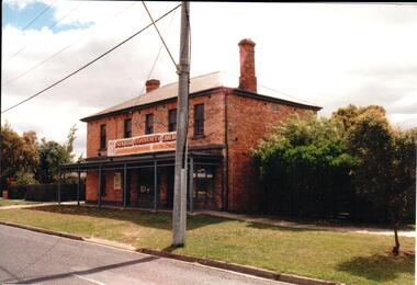
Since it was built in the 1860s the two storey brick building has had a number of commercial uses including butter and ice making, a general store, an equestrian store, an art gallery, a community Christian centre and a health studio. It has apparently been built in two stages because one section of the brickwork has a smoother finish.A coloured photograph of a two storey brick building with a slate roof. There is a shop front on the ground floor and 5 windows are on the 2nd storey. A verandah extends across the front of the lower storey to the edge of the footpath.butter and ice making, johnston, george, james, william, george evans collection -
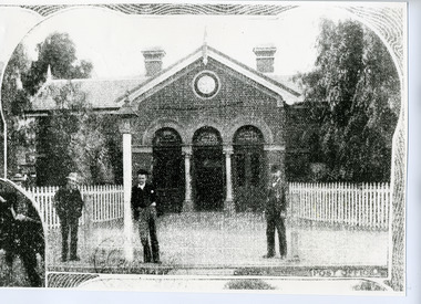 Charlton Golden Grains Museum Inc
Photograph, Weekly Times, Charlton Post Office c. 1920, c.1920
Charlton Post Office built in High Street in 1979 to replace original Post Office built in Camp St in 1878. A copy from probably the Weekly Times newspaper.Poor quality copy of photograph of Charlton Post Office. Brick building with a three arched entrance. Picket fene on either side. Three men standing on footpath, one is leaning on the lamp post.POST OFFICEcharlton post office, charlton -
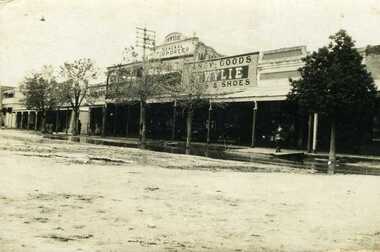 Charlton Golden Grains Museum Inc
Photograph, Flood 1911, c. 1911
High St Charlton showing W. Wylie General Store, 1911 floodSepia photo of High St Charlton showing W. Wylie General Store and Golden Fleece Hotel after the 1911 flood. Two children standing on footpath with water on the road in front of them.charlton, wylie's building, flood, high street -
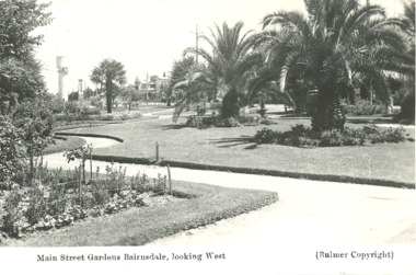 Lakes Entrance Historical Society
Postcard - Main Street gardens Bairnsdale Victoria, Bulmer, 1930 c
Black and white postcard with photograph of early Main Street gardens showing winding footpaths and palm trees and water tower and cenotaph in background Bairnsdale Victoria. plusTwo similar photographs of Bairnsdale gardens township, gardens -
 Eltham District Historical Society Inc
Negative - Photograph, J.A. McDonald, Eltham, Pryor Street, Sep. 1955
Construction of new concrete kerbing and footpath in Pryor Street, Eltham The truck on the left of the road is parked ouside the Eltham Police Station at No. 23. On the right is the present-day Woolworths carparkRecord of various Shire of Eltham infrastructure works undertaken during the period of 1952-1962 involving bridge and road reconstruction projects, sometimes with Eltham Shire Council Project Reference numbers quoted. It was during this period that a number of significant improvements were made to roads and new bridges constructed within the shire that remain in place as of present day (2022). In many situations, the photos provide a tangible visible record of infrastructure that existed throughout the early days of the Shire. The album was put together by or under the direction of the Shire Engineer, J.A. McDonald.1955-09, footpaths and gutters, pryor street, eltham police station, infrastructure, shire of eltham -
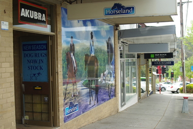 Greensborough Historical Society
Photograph - Digital image, Marilyn Smith, Horseland Greensborough 3, 18/08/2015
The Horseland store at 87 Main Street Greensborough was a local landmark with its model of a horse on the verandah roof. This store closed late in 2015. This view shows the footpath in front of the store.The Horseland store was a symbol of Greensborough's past as a country town.Digital copy of colour photographhorseland greensborough, main street greensborough -
 Eltham District Historical Society Inc
Photograph, Near 145 Mountainview Road, Briar Hill, early to mid 1960s, 1960s
Work is under way at the house one down from the bend where two piles of bluestone are gathered; possibly for terrace edging of the driveway and footpath. These images were from a strip of negatives, most likely taken by a Shire of Eltham employee so the works could have been part of council operations. Many streets in the shire have stonework edges for gardens abutting footpaths where the roads have been cut into the terrain. Much of this stone masonry work was undertaken for the council by C.J. Watson and Sons.Roll of medium format 120 6x6 black and white negative film, 1 stripbriar hill, c.j. watson and sons, fx holden, mountainview road, side-car, motorcycles -
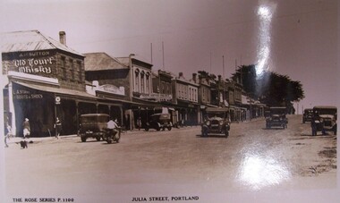 Glenelg Shire Council Cultural Collection
Postcard - Postcard - Julia Street, Portland, n.d
Black and white photograph of an unpaved street (Julia Street) with six cars and a motorbike on it. To the left is a row of buildings, painted different colours, some with awnings. People and dogs are walking on the footpath on the left side of the street.Front: THE ROSE SERIES. P. 1100/ COPYRIGHT (typed, lower left) JULIA STREET, PORTLAND (typed, lower centre)julia street, portland cbd -
Glenelg Shire Council Cultural Collection
Photograph - Photograph - Julia Street Porrtland, c. 1970
Photographic print of a rephotographed photograph. Image of north side of Julia Street between Percy and Bentinck Streets. Bluestone buildings - Woolstores of Henty, Learmonth & Co, Bank of Australasia on right. Numerous people on footpath.Front: 'Henty Woolstore - 2 Observer Buildings, Julia Street' - green ink Back: 'Bayview and Observer Printers' - blue biro