Showing 246 items
matching moonee ponds
-
 Melton City Libraries
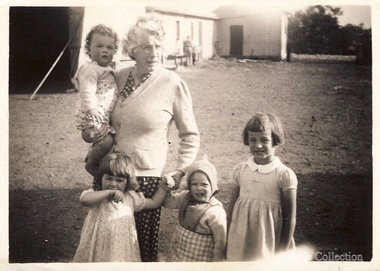
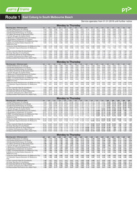
Photograph, Jessie Barrie with her grandchildren, 1946
... in Elizabeth Street, Moonee Ponds where the children attend Bank Street... in Elizabeth Street, Moonee Ponds where the children attend Bank Street ...Jessie, known as Ma Barrie to her grandchildren, was the daughter of a school teacher. The family lived in various locations around Central Victoria, particularly Pastoria and Melton. When her father was Head Teacher at Melton State School no 430, she met her future husband, CE Barrie. Jessie May married Charles Ernest Barrie in the Methodist Church Melton on the 23rd August 1906. They lived in the newly built house beside the Chaff Mill on the corner of Station and Brooklyn road Melton South. In April 1910 the family moved to a farm in Trundle NSW. The Chaff Mill was sold to Glover Onians - HSK Ward. The family returned to Melton in 1911, buying the “Darlingsford” farm in May. In 1916 they lived in Elizabeth Street, Moonee Ponds where the children attend Bank Street School, Ascot Vale. The children developed diphtheria Mary and Bon were transferred to Fairfield Hospital. In March 1919 the family returned to live at Melton at the time of the outbreak of the Spanish influenza. Mary, Bon and Edgar returned to Melton School. Following the death of CEB in a car accident in 1931 she was left to bring up her children on her own; the youngest Jim, aged 9 and eldest Mary, aged 24. Jessie left ‘Darlingsford’ in 1946 when her sons had safely returned from WW II. She stayed at Yarram for a time where her married twin daughters lived when more grandchildren were born and spent the remainder of her life living with various family members. Jessie died in 1960 while living with Mary and Keith.Jessie Barrie with her grandchildren at Darlingsford, Meltonlocal identities -
 Melbourne Tram Museum
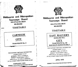
Ephemera - Timetable/s, Melbourne & Metropolitan Tramways Board (MMTB), "MMTB Tram Timetables", 1970
... - Route 82 - Footscray - Moonee Ponds - Feb 1970 .11 - Routes 48... Brunswick - City - March 1970 .10 - Route 82 - Footscray - Moonee ...Set of 12 MMTB Tram timetables, folded sheets, 10 sections, providing timetables for specific routes, day of week giving information on tram times at specific time points, route map, sections and fares and organisation address - 616 Little Collins St. Melbourne. .1 - Route 4 - Carnegie - City - Feb. 1970. .2 - City Route 4D - East Malvern - April 1970 - notes a bus route on Sundays only .3 - Routes 55 and 56 - West Coburg - City via Domain Road and William St - Sept. 1970 .4 - Route 65 and 64 - East Brighton - City - April 1970 .5 - Route 1, 2, 15 and 16, St Kilda Beach, South Melbourne Beach and City - March 1970. .6 - Route 5 - Malvern Burke Road - City - April 1970 .7 - Routes 48 and 74 - North Balwyn - Burwood - City September 1970 .8 - Route 59 - Essendon - city - July 1970 .9 - Routes 88 and 96 - East Preston - East Brunswick - City - March 1970 .10 - Route 82 - Footscray - Moonee Ponds - Feb 1970 .11 - Routes 48 and 74 - North Balwyn - Burwood - City September 1970 - Saturdays and Sundays, printed on pink paper. .12 - Routes 88 and 96 - East Preston - East Brunswick - City - March 1970 - Saturdays and Sundays, printed on pink paper.trams, tramways, mmtb, timetables, melbourne, fares, route 4, route 4d, route 55, route 56, route 64, route 65, route 1, route 2, route 15, route 16, st kilda beach, carnegie, east malvern, west coburg, east brighton, south melbourne beach, route 5, route 48, route 74, route 88, route 59, route 96, route 82 -
 Bendigo Historical Society Inc.
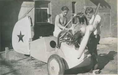
Photograph - Gliding in Bendigo, Late 1930s
... ). Alan grew up in Moonee Ponds, Victoria, and moved to Bendigo... These are the recollections of Alan Menere (1915 – 2001). Alan grew up in Moonee Ponds ...These are the recollections of Alan Menere (1915 – 2001). Alan grew up in Moonee Ponds, Victoria, and moved to Bendigo while in his early 20s. There he met some like-minded young men who enjoyed challenges and matters mechanical. Flying was the adventure of the time, and they decided to give it a go. There was no intention to be on the leading edge of gliding technology. The challenge was to fly, and by their own efforts. They were aided in this by the embryonic regulatory arrangements covering light aircraft construction and flying, a sense of optimistic can-do, and the cavalier estimation of risks that goes with being in your early 20s. The events described here took place against a darkening political background. Alan and his mates were politically aware, very left wing, and viewed the gathering storm in Europe with apprehension. They could see from early on that war was coming, and it would change everything. Prevented from joining the Air Force by his red-green colour blindness, Alan joined the Army the day after the Pearl Harbour attack. He served in an Armoured Reconnaissance Unit in Western Australia, then with the Army Education Service in New Britain. After the War he joined the Commonwealth Public Service. He moved to Canberra, but his Bendigo habits stayed with him, as he built sailboards and carved propellers, to the admiration of his sons. Alan developed macular degeneration in his mid-60s. He retired to Port Stephens, fishing and socializing when he wasn’t tinkering with wing-sails for his catamaran. As he could touch-type, he quickly learned to use a computer. Very aware that he was the last member of the Bendigo group still alive, he resolved to set down his flying experiences. The images he selected are included, but there are many more from the Bendigo days.A CD entitled "Alan Menere - Recollections of Gliding in Bendigo in the late 1930s". The CD contains 33 documents consisting of one word file, one PDF file (entitled "The Urge to Fly") and the rest are of either photos of the Bendigo Gliding club or generally around Bendigo itself. Also included are some paper clippings of accidents that happened and description of flights.history, bendigo, bendigo gliding club, alan menere -
 Melbourne Tram Museum
Ephemera - Timetable/s, Public Transport Victoria (PTV), Set of 25 digital timetables, 2018
... - Footscray - Moonee Ponds Route 86 - Bundoora RMIT - Waterfront City... - Footscray - Moonee Ponds Route 86 - Bundoora RMIT - Waterfront City ...Set of 25 digital timetables generally applicable from 20-05-2018 following the introduction of more frequent services on many routes. Image files are htd2860iRx - x being the route number. Route 1 - East Coburg - South Melbourne Beach Route 3 and 3A - Melbourne University - East Malvern - and via St Kilda Beach Route 5 - Melbourne University - Malvern Route 6 - Melbourne University - Glen Iris Route 8 - Moreland - Toorak Route 11 - West Preston - Victoria Harbour Docklands Route 12 - Victoria Gardens - St Kilda Route 16 - Melbourne University - Kew Via St Kilda Route 19 - North Coburg - Flinders St Route 30 - St Vincent's Plaza - Etihad Stadium Docklands Route 35 - City Circle Route 48 - North Balwyn - Victoria Harbour Docklands Route 55 - West Coburg - Domain Interchange Route 57 - West Maribyrnong - Flinders St Route 59 - Airport West - Flinders St Route 64 - East Brighton - Melbourne University Route 67 - Carnegie - Melbourne University Route 70 - Wattle Park - Waterfront City Docklands Route 72 - Camberwell - Melbourne University Route 75 - Vermont South - Etihad Stadium Docklands Route 78 - North Richmond - Balaclava via Prahran Route 82 - Footscray - Moonee Ponds Route 86 - Bundoora RMIT - Waterfront City Docklands Route 96 - East Brunswick - St Kilda Beach Route 109 - Box Hill - Port Melbournetrams, tramways, timetables, yarra trams, route 1, route 3, route 5, route 6, route 8, route 11, route 12, route 16, route 19, route 30, route 35, route 48, route 55, route 57, route 59, route 64, route 67, route 70, route 72, route 75, route 78, route 82, route 86, route 96, route 109 -
 Melbourne Tram Museum
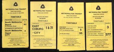
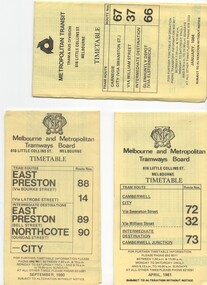
Ephemera - Timetables - Metropolitan Transit - set of 22, Metropolitan Transit Authority (MTA), 1983 and 1984
... Richmond - July 1984 20 - route 82 and 223 - Footscray - Moonee... - route 82 and 223 - Footscray - Moonee Ponds and bus on Sundays ...Timetables - provides information on fare sections and a route map. 1 - Routes 1, 2 & 4 - South Melbourne - City - July 1984 2 - Route 1 & 21 - East Coburg - City August 1983 3 - Route 5 and 35 - Malvern Burke Road - July 1984 4 - Route 3 and 377 - East Malvern (Darling Road) and bus route on Sundays only - Jan. 1984 5 - Route 6, 36 and 7 - Glen Iris - July 1984 6 - Route 8 and 38 - Toorak - June 1984 7 - Route 9 and 14 - Northcote - June 1984 8 - Route 10 & 11, 13 - West Preston - May 1984 9 - Route 15 & 22 - Moreland - July 1983 10 - Route 15 & 16, 53 & 55 - St Kilda Beach - July 1983 11 - Route 19, 20 and 18 (MMTB) - North Coburg - Oct. 1982 12 - Route 42, 23, 44, 45 and 47 - Mont Albert - July 1984 13 - Route 48, 24, 40, 41 and 29 - North Balwyn - Nov. 1983 14 - Route 57, 357, 54, 60, 58 and 50 - West Maribyrnong - bus on Sundays - July 1984 15 - Route 64, 65, 62 and 61 - East Brighton - Jan. 1984 16 - Route 67, 37, and 66 - Carnegie - Jan. 1984 17 - route 70, 71 and 76 - Wattle Park - June 1984 18 - route 75, 74, 76 and 28 - East Burwood - JIan. 1984 19 - route 77, 78 and 79 - Prahran - North Richmond - July 1984 20 - route 82 and 223 - Footscray - Moonee Ponds and bus on Sundays and Saturdays - June 1984 21 - route 88, 14, 89 and 90 - East Preston - July 1983 22 - route 96, 95 and 97 - East Brunswick - July8 1984Yields information about Metropolitan Transit services during the mid 1980s.Set of 22 Metropolitan Transit tram timetables - multifold printed on yellow paper.timetable, metropolitan transit, the met, route 1, route 2, route 4, route 21, route 5, route 35, route 3, route 377, route 6, route 36, route 7, route 8, route 38, route 9, route 14, route 10, route 11, route 13, route 15, route 22, route 16, route 53, route 55, route 19, route 18, route 20, route 42, route 23, route 44, route 45, route 47, route 48, route 24, route 40, route 41, route 29, route 57, route 357, route 54, route 60, route 58, route 50, route 64, route 65, route 62, route 61, route 67, route 37, route 66, route 70, route 71, route 76, route 75, route 74, route 28, route 77, route 78, route 79, route 82, route 223, route 99, route 89, route 90, route 96, route 95, route 97 -
 Melbourne Tram Museum
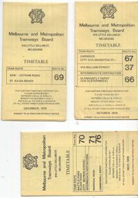
Ephemera - Timetable/s, Melbourne & Metropolitan Tramways Board (MMTB), "MMTB Tram Timetables", 1977 to 1978
... ) and Camberwell Junction (73) dated Sept, 1978. .5 - Route 82 - Moonee...) and Camberwell Junction (73) dated Sept, 1978. .5 - Route 82 - Moonee ...Set of 6 MMTB Tram timetables, folded sheets, 8 sections, providing timetables for specific routes, day of week giving information on tram times at specific time points, route map, sections and fares and organisation address - 616 Little Collins St. Melbourne. All printed on yellow paper. 1. - Route 67, 37 and 66 - Carnegie - City via Swanston St (67), via William St (37) and Glenhuntly Depot (66) - dated Oct. 1978. .2 - Route 69 - Kew Cotham Road - St Kilda Beach dated Dec. 1978 .3 - Route 70, 71 and 76 - Wattle Park - Batman Ave, Arraign Road (Route 71) and Camberwell Depot (Route 76), dated May 1978 .4 - Route 72, 32 and 73 - Camberwell City via Swanston St (72), via William St (32) and Camberwell Junction (73) dated Sept, 1978. .5 - Route 82 - Moonee Ponds - Footscray - Highpoint West - dated Sept. 1977 .6 - Route 88, 14, 89 and 90, 96, 95 and 97 - East Preston via Bourke St (88), via Latrobe St (14), East Preston Bell St (89) and Northcote Dundas St (90) to the city and East Brunswick (96), Exhibition (95) and North Fitzroy (Park St), dated May 1978. .7 - Routes 48, 24, 40, 41, 29, 74, 76. 28 - July 1978 .8 - ditto - Weekends, July 1978, printed on green paper. .9 - Bus routes 284 (East Kew - Doncaster North) and 270 (East Kew - Shoppingtown) - dated August 1978trams, tramways, mmtb, timetables, melbourne, fares, route 14, route 32, route 37, route 66, route 67, route 69, route 70, route 71, route 72, route 73, route 76, route 82, route 88, route 89, route 90, route 95, route 96, route 97, route 48, route 24, route 40, route 41, route 29, route 74, route 76, route 28, route 284, route 270 -
 Federation University Historical Collection
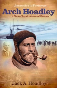
Book, Jack A. Hoadley, Antarctica to Footscray: Arch Hoadley, 2010, 2010
... to 1937. The scout area of Moonee Ponds is named the Hoadley Area... of Moonee Ponds is named the Hoadley Area in his honour. Charles ...Predominantly brown covered paperback of 460 pages featuring an image of Arch Hoadley in Antarctica on the cover.non-fictionballarat school of mines, antarctica, footscray technical school, baden powell, scouts, douglas mawson, arch hoadley -
 Melbourne Tram Museum
Ephemera - Set of 24, Melbourne & Metropolitan Tramways Board (MMTB), "MMTB Tram Timetables", 1969
... Kilda Beach 21 - Route 82 - Footscray - Moonee Ponds - bus... - Route 82 - Footscray - Moonee Ponds - bus route Saturday ...Set of 23 timetables for specific routes, day of week giving information on tram times at specific time points, route map, sections and fares and organisation address - 616 Little Collins St. Melbourne. All July 1969. The first set of timetables issued in this format. 1- Route 4 - Carnegie - City 2 - Route 5 - Malvern (Burke Rd.) - City 3 - Route 6 - Glen Iris - City 4 - Route 7 - Camberwell - City 5 - Route 8 - Toorak - City 6 - Route 9, 10 and 12 - South Melbourne and St Kilda Beach - City 7 - Routes 10, 11, 9 and 9A - West Preston Northcote - City 8 - Route 1, 2A, 15, 16 - St Kilda Beach - South Melbourne - City 9 - Route 1, 15, 21, 22 - Moreland - East Coburg - City 10 - Route 19 - North Coburg - City 11 - Route 42 - Mont Albert - City 12 - Route 48, 74 - North Balwyn - Burwood - City 13 - ditto - Saturdays and Sundays - printed on pink paper 14 - Route 55, 56 - West Coburg - Domain Road - via William St 15 - Route 57 - West Maribyrnong - City - bus route Sundays only 16 - Route 59 - Essendon Aerodrome - City 17 - Route 64, 65 - East Brighton - via Swanston St/ William St 18 - Route 69 - Kew Cotham Road - St Kilda Beach 19 - Route 70 - Wattle Park - City 20 - Route 77, 78, 79 - Prahran - City, North Richmond - Prahran - St Kilda Beach 21 - Route 82 - Footscray - Moonee Ponds - bus route Saturday afternoon and Sundays 22 - Route 88 and Route 96 - East Preston, East Brunswick - city - July 1969, printed on white paper. - Weekdays and Sundays 23 - Route 88, 96 - East Preston and East Brunswick (Blyth St)< Saturdays, Xmas day and Good Fri - printed on pink paper. 24 - Route 4D - East Malvern (Darling Road) - City, bus route Sundays only Yields information about MMTB Tram services during 1969Set of 24 MMTB Tram timetables, folded sheets.trams, tramways, mmtb, timetables, melbourne, fares, route 69, route 64, route 88, route 96, route 4, route 4d, route 5, route 6, route 7, route 8, route 9, route 9a, route 10, route 11, route 12, route 1, route 15, route 21, route 22, route 2a, route 15, route 16, route 19, route 42, route 48, route 74, route 55, route 56, route 57, route 59, route 65, route 70, route 77, route 78, route 79, route 82 -
 Melbourne Tram Museum
Ephemera - Timetable/s, Public Transport Victoria (PTV), 2019
... Prahran Route 82 - Footscray - Moonee Ponds Route 86 - Bundoora... Prahran Route 82 - Footscray - Moonee Ponds Route 86 - Bundoora ...Set of 24 digital timetables generally applicable from 1-1-2019. Image files are htd3520iRx - x being the route number. Route 1 - East Coburg - South Melbourne Beach Route 3 and 3A - Melbourne University - East Malvern - and via St Kilda Beach - two timetables for each Route 5 - Melbourne University - Malvern Route 6 - Melbourne University - Glen Iris Route 11 - West Preston - Victoria Harbour Docklands Route 12 - Victoria Gardens - St Kilda Route 16 - Melbourne University - Kew Via St Kilda Route 19 - North Coburg - Flinders St Route 30 - St Vincent's Plaza - Etihad Stadium Docklands - though the stadium was renamed Marvel after Marvel comics by Disney during May 2018. Old name retained, but appears to becoming just Docklands Stadium on Yarra trams website when this item added. Route 35 - City Circle - NOT Published. Route 48 - North Balwyn - Victoria Harbour Docklands Route 55 - West Coburg - Domain Interchange Route 57 - West Maribyrnong - Flinders St Route 58 - Toorak to Route 59 - Airport West - Flinders St Route 64 - East Brighton - Melbourne University Route 67 - Carnegie - Melbourne University Route 70 - Wattle Park - Waterfront City Docklands Route 72 - Camberwell - Melbourne University Route 75 - Vermont South - Etihad Stadium Docklands Route 78 - North Richmond - Balaclava via Prahran Route 82 - Footscray - Moonee Ponds Route 86 - Bundoora RMIT - Waterfront City Docklands Route 96 - East Brunswick - St Kilda Beach Route 109 - Box Hill - Port Melbournetrams, tramways, timetables, yarra trams, route 1, route 3, route 5, route 6, route 8, route 11, route 12, route 16, route 19, route 30, route 48, route 55, route 57, route 58, route 59, route 64, route 67, route 70, route 72, route 75, route 78, route 82, route 86, route 96, route 109 -
 Melton City Libraries
Photograph, Ian and Wendy with Grandma Barrie, c.1943
... in Moonee Ponds where the children attend Bank Street School, Ascot.... Their address was Elizabeth Street Moonee Ponds. William Cecil was born ...Jessie May born on 30th November 1883, Jessie, known as Ma Barrie to her grandchildren, was the daughter of schoolteacher, Thomas John Lang and Mary Elizabeth Coates. In 1896 Thomas and Mary Elizabeth moved to Melton. Mr Lang’s previous school was Coliban SS No 1920. Mr Lang was the Head Teacher at Melton until 1917. In 1910 he was a Committee Member Melton Mechanics Institute and Public Library at its establishment. He was a Life Member of the Melton Mechanics Institute Jessie lived in various locations around Central Victoria, particularly Pastoria and Melton. When her father was Head Teacher at Melton State School no 430, she met her future husband, Charles Ernest Barrie. The couple were married at the Methodist Church Melton on the 23rd August in 1906. They lived in the newly built house beside the Chaff Mill on the corner of Station and Brooklyn Road Melton South. Their eldest child was Mary Ena was born on the 7th of October 1907. IN 1909, Ernest Wesley (Bonnie) was born 29th April (Ascot Vale). In 1910 the family moved to a farm in Trundle NSW. The Chaff Mill was sold to Glover Onians – HSK Ward. Later the original mill was burnt and replaced, and in 1977 a fire destroyed it again and it was not rebuilt. In 1911, the family returned to Melton buying the “Darlingsford” farm in May. The weather was too at Trundle for Jessie. Their address was Elizabeth Street Moonee Ponds. William Cecil was born on the 23rd of February 1912 and Charles Edgar was born on 1st June 1913. In 1916 they lived in Moonee Ponds where the children attend Bank Street School, Ascot Vale. The children developed diphtheria Mary and Bon were transferred to Fairfield Hospital. March 1919 the family returned to live at Melton at the time of the outbreak of the Spanish influenza. Mary, Bon, and Edgar returned to Melton School. Following the death of CEB in a car accident in 1931 she was left to bring up her children on her own; the youngest Jim, aged 9 and eldest Mary, aged 24. Jessie left ‘Darlingsford’ in 1946 when her sons had safely returned from WW II. She stayed at Yarram for a time where her married twin daughters lived when more grandchildren were born and spent the remainder of her life living with various family members. SUMMARY - Dr Ian Robinson OAM Born 26th June 1931 Parents – Keith John Robinson of “Creighton” Melton Mary nee Barrie of “Darlingsford” Melton The family lived at “Heatherdale” Toolern Vale. Their 3 children, Ian the first followed by daughters, Ena May and Mary Elizabeth (Beth) Ian and Ena attended Toolern Vale State School. No 946 The family later moved to Columban Ave Strathmore. During 1942 the children stayed their grandmother’s house at “Darlingsford” Melton. They enrolled at Melton State School No 430 on the 13/3/42 after attending State School No 483 Raleigh Street Essendon. They left Melton School on the 31/7/42 returning to Essendon. Ian attended Geelong College as a boarder after completing his schooling he entered University to study Medicine. His early General Practice was in Melbourne. In 1972 he joined the Royal Flying Doctor at Mount Isa, North West Region of Queensland. The region covered an area larger than the British Isles. He was on call 24 hours for emergencies. He spent three weeks away with calls and in the fourth week attended Aboriginal Reserves. Ian took two Queensland Governors and their wives to spend three nights at the Clinic. Sir Colin and Lady Hannah are still their friends. Area Co-ordinator Ian was awarded the Royal Humane Society Medal along with his pilot when they risked their lives landing on flooded land to save a patient. Ian remained a loyal contributor to the Royal Flying Doctor Service until 1997 He met Queen Elizabeth 2nd in Cairns, and also met Prince Phillip and Prince Andrew in Brisbane. Townsville – Locum Beenleigh – General Practice Open 7 Days 198? -2002 Aspects of his work covered the following – Police Work State Commonwealth Medical Officer TEYS COMPANY Q FEVER. Q Fever presents with flu like symptoms. The 1st Test always came back Negative BUT 2nd Test always positive. Ian lectured other Medicos re Q Fever Council Immunization in schools Covered boxing bouts Large Practice In 2002 Ian retired but continued house calls for older patients. Information from Anne to Beth received by Wendy October 2013 Wendy Elizabeth Barrie Jessie May Lang [Barrie] and Ian Keith Robinson standing in front of a carlocal identities -
 Melbourne Tram Museum
Ephemera - Timetable/s, Public Transport Victoria (PTV), Set of 25 digital timetables - Yarra Trams, 2016
... - Balaclava via Prahran Route 82 - Footscray - Moonee Ponds Route 86... - Balaclava via Prahran Route 82 - Footscray - Moonee Ponds Route 86 ...Set of 25 digital timetables generally applicable 2016 to 13/4/2017. Similar timetables ran during 13/4/2017 and 1/5/2017 over the Easter Holiday period up to when Route 58 (from route 8 and route 55) introduced and route 6 modified - see Reg item 2212 for details. List major stops only. All downloaded from the PTV website 9-4-17 as pdf files. Image files are htd2211iRx - x being the route number. Route 1 - East Coburg - South Melbourne Beach Route 3 and 3A - Melbourne University - East Malvern - and via St Kilda Beach Route 5 - Melbourne University - Malvern Route 6 - Melbourne University - Glen Iris Route 8 - Moreland - Toorak Route 11 - West Preston - Victoria Harbour Docklands Route 12 - Victoria Gardens - St Kilda Route 16 - Melbourne University - Kew Via St Kilda Route 19 - North Coburg - Flinders St Route 30 - St Vincent's Plaza - Etihad Stadium Docklands Route 35 - City Circle Route 48 - North Balwyn - Victoria Harbour Docklands Route 55 - West Coburg - Domain Interchange Route 57 - West Maribyrnong - Flinders St Route 59 - Airport West - Flinders St Route 64 - East Brighton - Melbourne University Route 67 - Carnegie - Melbourne University Route 70 - Wattle Park - Waterfront City Docklands Route 72 - Camberwell - Melbourne University Route 75 - Vermont South - Etihad Stadium Docklands Route 78 - North Richmond - Balaclava via Prahran Route 82 - Footscray - Moonee Ponds Route 86 - Bundoora RMIT - Waterfront City Docklands Route 96 - East Brunswick - St Kilda Beach Route 109 - Box Hill - Port Melbournetrams, tramways, timetables, yarra trams, route 1, route 3, route 5, route 6, route 8, route 11, route 12, route 16, route 19, route 30, route 35, route 48, route 55, route 57, route 59, route 64, route 67, route 70, route 72, route 75, route 78, route 82, route 86, route 96, route 109 -
 Melbourne Tram Museum
Ephemera - Timetable/s, Public Transport Victoria (PTV), Set of 24 digital timetables - Yarra trams, 2016
... - Footscray - Moonee Ponds Route 86 - Bundoora RMIT - Waterfront City... - Footscray - Moonee Ponds Route 86 - Bundoora RMIT - Waterfront City ...Set of 24 digital timetables generally applicable 1/4/2017 to end 2017 Introduced when Route 58 (from route 8 and route 55) amalgamated and route 6 modified - see Reg item 2212 for details. All downloaded from the PTV website 9-4-17 as pdf files, except for routes 6 and 58 which had not been published as of that date. Timetables list major stops. Routes 6 and 58 files added 6-6-2017. Image files are htd2213iRx - x being the route number. Route 1 - East Coburg - South Melbourne Beach Route 3 and 3A - Melbourne University - East Malvern - and via St Kilda Beach Route 5 - Melbourne University - Malvern Route 6 - Moreland - Glen Iris Route 11 - West Preston - Victoria Harbour Docklands Route 12 - Victoria Gardens - St Kilda Route 16 - Melbourne University - Kew Via St Kilda Route 19 - North Coburg - Flinders St Route 30 - St Vincent's Plaza - Etihad Stadium Docklands Route 35 - City Circle Route 48 - North Balwyn - Victoria Harbour Docklands Route 57 - West Maribyrnong - Flinders St Route 58 - Toorak - West Coburg via William St. Route 59 - Airport West - Flinders St Route 64 - East Brighton - Melbourne University Route 67 - Carnegie - Melbourne University Route 70 - Wattle Park - Waterfront City Docklands Route 72 - Camberwell - Melbourne University Route 75 - Vermont South - Etihad Stadium Docklands Route 78 - North Richmond - Balaclava via Prahran Route 82 - Footscray - Moonee Ponds Route 86 - Bundoora RMIT - Waterfront City Docklands Route 96 - East Brunswick - St Kilda Beach Route 109 - Box Hill - Port Melbournetrams, tramways, timetables, yarra trams, route 1, route 3, route 5, route 6, route 11, route 12, route 16, route 19, route 30, route 35, route 48, route 57, route 58, route 59, route 64, route 67, route 70, route 72, route 75, route 78, route 82, route 86, route 96, route 109 -
 Melbourne Tram Museum
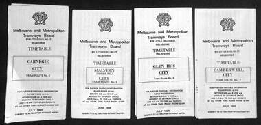
Document - Timetable/s, Melbourne & Metropolitan Tramways Board (MMTB), "MMTB Tram Timetables", 1980 - 1984
... - Route 82 and 223 - Footscray - Moonee Ponds - tram and bus - Jan... Richmond - Nov 1979 .6 - Route 82 and 223 - Footscray - Moonee ...Set of 13 MMTB Tram timetables, folded sheets, 10 sections, providing timetables for specific routes, day of week giving information on tram times at specific time points, route map, sections and fares and organisation address - 616 Little Collins St. Melbourne. .1 - Route 72, 32 and 73 - Camberwell City via Swanston St (72), via William St (32) and Camberwell Junction (73) printed on yellow paper, dated April 1981 .2 - Route 88, 14, 89 and 90 - East Preston via Bourke St (88), via Latrobe St (14), East Preston Bell St (89) and Northcote Dundas St (90) to the city, printed on yellow paper, dated September 1980. .3 - Route 67, 37 and 66 - Carnegie - City via Swanston St (67), via William St (37) and Glenhuntly Depot (66) - printed on yellow paper, dated Jan. 1984 -has the Metropolitan Transit Logo. .4 - Route 70, 71 and 76 - Wattle Park - Nov 1979 .5 - Route 77, 78 and 79 - Prahran - City, Prahran - North Richmond - Nov 1979 .6 - Route 82 and 223 - Footscray - Moonee Ponds - tram and bus - Jan 1981 .7 - Route 1, 2, 4 - South Melbourne Beach - Feb 1981 .8 - Route 5 and 35 - Malvern - April 1981 .9 - route 70, 71, 76 - Wattle Park - April 1981 .10 - Route 15, 16, 53 and 55 - St Kilda Beach - Feb 1981 .11 - Route 6, 36. 7 - Glen Iris - July 1981 .12 - Route 59, 49, 51, 52, 82 - Essendon Airport March 1982 .13 - Route 48, 24, 40, 41, 29 North Balwyn - March 1982trams, tramways, mmtb, timetables, melbourne, fares, route 1, route 2, route 4, route 5, route 6, route 7, route 14, route 15, route 16, route 24, route 29, route 32, route 35, route 36, route 37, route 40, route 41, route 48, route 49, route 51, route 52, route 53, route 55, route 59, route 66, route 67, route 70, route 71, route 72, route 73, route 76, route 77, route 78, route 79, route 81, route 82, route 88, route 89, route 90, route 223 -
 Melbourne Tram Museum
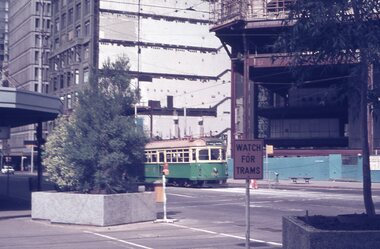
Album - Robert Thomson Slide Collection, "Melbourne 1970 - 1979"
... - "Moonee Ponds" - route 22 RT274 St Kilda Rd, tram 8 - "Special... - "Moonee Ponds" - route 22 RT274 St Kilda Rd, tram 8 - "Special ...Photo - see pdf file for further information. Number Brief Description RT264 Elizabeth St, at Bourke St, with the construction of the State Savings Bank building (State Bank Galleria) underway. Bourke St Mall also under construction, Note tram warning Sign, tram 1065 - "West Maribyrnong" - route 57 RT265 St Kilda Road, tram 778 - "City" -route 59 RT266 St Kilda Road, tram 569 - "East Malvern Darling Road" -route 3 & tram 819 - "Glen Iris" - route 6 RT267 Swanston St, tram 538 - "City" - route 2A RT268 St Kilda Junction, tram 924 - "City" - route 5 RT269 St Kilda jct, tram 280 - "St Kilda Beach" - route 15 RT270 St Kilda Road, tram 507 - "City" - route 72 RT271 Nicholson St Gertrude St - tram7 - "East Preston Tyler St" - route 88 RT272 West Coburg, tram 778 - "Domain Rd" - route 55 RT273 Wests Road, tram 750 - "Moonee Ponds" - route 22 RT274 St Kilda Rd, tram 8 - "Special" RT275 Nicholson St Victoria Pde, tram 10W - "Special" RT276 L Class Queens way, "City" - route 54 RT277 Bourke St at Spring St, tram 998 - "East Coburg" - route 88 RT278 Nicholson St MMTB Bus, bus 562 - "Garden City via Port Melb" - route 2 RT279 Church St Burwood Rd Jct, tram 9 - "Special" RT280 Riversdale Rd at Camberwell Depot - "Burwood" - route 74 RT281 Balaclava Junction - tram 819 - "Kew Cotham Rd" - route 69 RT282 East Brunswick Terminus, tram 4 - "City Spencer St" - route 96 RT283 Peel St - tram 927 - "Special" RT284 East Brighton Terminus - tram 563 & tram 926 - "City" - route 64 RT285 Dandenong Rd Hawthorn Rd, tram 346 - route 64 RT286 Bourke St at Spring St, tram 34 - "North Fitzroy Park St" - route 97 RT287 Route 69 Terminus St Kilda - tram 369 - "Kew Cotham rd" - route 69 RT288 Route 78 Terminus St Kilda, tram 498 - "North Richmond" - route 78 RT289 Track relay, Fitzroy St, St Kilda RT290 Fitzroy St, St Kilda Demonstrates the work of Robert Thomson in photography, collection and/or production of slidesAssembled album in a black presentation folder of 27 colour slides, collected or produced by Robert Thomson. All photographs have been scanned and placed on the Museum's G drive. A list of all photographs with details has been compiled. melbourne, tramways, trams, track construction, elizabeth st -
 Melbourne Tram Museum
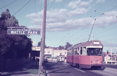
Album - Robert Thomson Slide Collection - box 15
... Road RT343 31-3-1975 PCC 1041 at Moonee Ponds Junction...-1975 PCC 1041 at Moonee Ponds Junction RT344 1989 SW6 914 ...Photo - see pdf file for further information. Number Date Brief Description RT341 14-4-1974 PCC1041 at Wattle Park RT342 17-4-1974 St Kilda Road Extension – was High St and Brighton Road RT343 31-3-1975 PCC 1041 at Moonee Ponds Junction RT344 1989 SW6 914 Truganini Road, single line RT345 Jan 90 Z59 westbound in La Trobe St route 89 RT346 Apr 89 W 380 Albert Road with A283 on St Kilda line over bridge (Tours database provides a date of 25-6-1989 for an ARHS tour) RT347 1989 Truganini Rd duplication work RT348 1989 Truganini Rd duplication work RT349 1989 Truganini Rd duplication work’ RT350 Jan 90 SW5 763 Balaclava Junction RT351 Apr 1989 W2 533 Overhead test car Victoria Parade and B class RT352 Apr 1989 W2 533 overhead test car Port Melbourne line RT353 Apr 1989 ditto at Port Melbourne station RT354 Jan 1990 11W scrubber in William St RT355 1986 Transport Art tram SW5 731 - Painted by Lesley Dumbrell RT356 Apr 89 SW6 869 leaving Malvern depot RT357 Apr 89 W1 431 on tour – Truganini Road RT358 Apr 89 W1 431 at East Brighton terminus RT359 Apr 89 W380 and W1 431 on tour Albert Road South Melbourne RT360 Apr 89 W1 431 East Malvern Darling Road RT361 c1989 L 104 William St and Z95 at La Trobe St RT362 c1989 L 104 Peel St RT363 Jan 1990 SW6 921 Balaclava Junction RT364 Apr 1989 B2 2007 Victoria Parade RT365 Apr 1989 B2 2007 Mont Albert terminus RT366 Apr 1989 B2 2007 Bundoora line Plenty Road RT367 Apr 1989? Z3 209 and B2 200) at Bundoora terminus RT368 Apr 1989? B2 2009 and Z2 111 at Bundoora terminus RT369 Apr 1989 W5 839 and W1 431 Truganini Road RT370 Apr 1989 W1 380 Albert Road and B2 on over bridge RT371 Apr 1989 SW6 923 Dandenong Road Demonstrates the work of Robert Thomson in photography, collection and/or production of slidesAssembled album in a black presentation folder of 30 colour slides, collected or produced by Robert Thomson. A list of all photographs with details has been compiled. melbourne, tramways, trams, tram 1041, wattle park, st kilda road, tram 914, tram 59, truganini road, tram 380, st kilda light rail, tram 283, tram 763, balaclava junction, tram 533, port melbourne, tram 11w, william st, transporting art, tram 869, tram 431, tram 104, east malvern, east brighton, peel st, victoria parade, mont albert, bundoora, tram 2007, tram 209, tram 2009, tram 111, tram 839, albert road, tram 923, dandenong road -
 Eltham District Historical Society Inc
Photograph, Murchison Gap, Autumn Excursion, Hume and Hovell's 1824 expedition, 26 May 1996, 26/05/1996
... of the Moonee Ponds Creek, we experienced the landscape the first... of the Moonee Ponds Creek, we experienced the landscape the first ...[article by Bettina Woodburn in EDHS Newsletter No. 109, July 1996:] ON THE TRAIL OF HUME AND HOVELL - REPORT ON THE AUTUMN EXCURSION - On a green and fresh morning (Sunday 26th May 1996) the Cobb and Co coach (driven by the most obliging Peter Tampion) set off in a north easterly direction from Eltham to connect with Hume and Hovell's route on their 1824 explorations of central Victoria. The Society would follow a series of monuments erected for the 1924 centenary of the expedition from King Parrot Creek (Tuesday 7th December 1824), through Strath Creek, over Sunday Creek (Sunday 12th December 1824) at Broadford, Tullamarine, St Albans, Deer Park, through Werribee, skirting east of the You Yangs to Lara and Avalon Beach. Because their distance-measuring wheel had broken and a one degree mistake was made in calculations, the two leaders of the original group of six convict-companions arrived at Corio Bay, instead of the expected Western Port, discovered earlier by Flinders. From below Mt. Disappointment (Hume and Hovell's difficulties in "scrambling over brush and rock", "leeches in forest, as well as no water", "cutting grass 4-5 ft. high", dreadful scrub", "devil flies") we took an easier route, saw the Strath Creek memorial in ground fog and a wonderful "field of dreams", the Hume-Hovell privately owned cricket ground with its white picket boundary fence. Now, after a steep climb, in sunshine under gums we stretched and viewed magnificent rolling hills and fog-filled valleys - not "smoke from Aborigines' bush fires". After morning tea at Broadford we followed the Sunday Creek valley beside the Hume Freeway, passed the Wallan Wallan Rest Area (more appropriately Hume and Hovell Rest Area) to tum right at Beveridge. In Gellibrand Hill Park, near the headwaters of the Moonee Ponds Creek, we experienced the landscape the first European settlers saw - huge river red gums and rolling pastures. The gardens and sheltered courtyard of the 1840s, timber, brought from .....[?] prefabricated Woodlands Homestead, provided a pleasant lunch stop. We enjoyed a private tour, panoramic views over Melbourne and surroundings and the excitement of arriving and departing aircraft. Our next river crossing was at Werribee, "in a vast treeless plain", then we drove on by-ways no coach had previously travelled, to find "an immense sheet of water" salty Corio Bay, off-course to the west. In late afternoon of a super, calm, late autumn day we headed homewards. Back at Eltham we were rather surprised to find that we had travelled a total of 347 km. Thanks again to Russell Yeoman for his research and organization. What a wonderful day! Three colour photographsactivities, murchison gap, murchison valley -
 Eltham District Historical Society Inc
Photograph, Hume and Hovell Monument, Broadford, Autumn Excursion, Hume and Hovell's 1824 expedition, 26 May 1996, 26/05/1996
... of the Moonee Ponds Creek, we experienced the landscape the first... of the Moonee Ponds Creek, we experienced the landscape the first ...[article by Bettina Woodburn in EDHS Newsletter No. 109, July 1996:] ON THE TRAIL OF HUME AND HOVELL - REPORT ON THE AUTUMN EXCURSION - On a green and fresh morning (Sunday 26th May 1996) the Cobb and Co coach (driven by the most obliging Peter Tampion) set off in a north easterly direction from Eltham to connect with Hume and Hovell's route on their 1824 explorations of central Victoria. The Society would follow a series of monuments erected for the 1924 centenary of the expedition from King Parrot Creek (Tuesday 7th December 1824), through Strath Creek, over Sunday Creek (Sunday 12th December 1824) at Broadford, Tullamarine, St Albans, Deer Park, through Werribee, skirting east of the You Yangs to Lara and Avalon Beach. Because their distance-measuring wheel had broken and a one degree mistake was made in calculations, the two leaders of the original group of six convict-companions arrived at Corio Bay, instead of the expected Western Port, discovered earlier by Flinders. From below Mt. Disappointment (Hume and Hovell's difficulties in "scrambling over brush and rock", "leeches in forest, as well as no water", "cutting grass 4-5 ft. high", dreadful scrub", "devil flies") we took an easier route, saw the Strath Creek memorial in ground fog and a wonderful "field of dreams", the Hume-Hovell privately owned cricket ground with its white picket boundary fence. Now, after a steep climb, in sunshine under gums we stretched and viewed magnificent rolling hills and fog-filled valleys - not "smoke from Aborigines' bush fires". After morning tea at Broadford we followed the Sunday Creek valley beside the Hume Freeway, passed the Wallan Wallan Rest Area (more appropriately Hume and Hovell Rest Area) to tum right at Beveridge. In Gellibrand Hill Park, near the headwaters of the Moonee Ponds Creek, we experienced the landscape the first European settlers saw - huge river red gums and rolling pastures. The gardens and sheltered courtyard of the 1840s, timber, brought from .....[?] prefabricated Woodlands Homestead, provided a pleasant lunch stop. We enjoyed a private tour, panoramic views over Melbourne and surroundings and the excitement of arriving and departing aircraft. Our next river crossing was at Werribee, "in a vast treeless plain", then we drove on by-ways no coach had previously travelled, to find "an immense sheet of water" salty Corio Bay, off-course to the west. In late afternoon of a super, calm, late autumn day we headed homewards. Back at Eltham we were rather surprised to find that we had travelled a total of 347 km. Thanks again to Russell Yeoman for his research and organization. What a wonderful day! Colour photographactivities, broadford, hume and hovell, monument -
 Eltham District Historical Society Inc
Photograph, Hume and Hovell Monument, Autumn Excursion, Hume and Hovell's 1824 expedition, 26 May 1996, 26/05/1996
... of the Moonee Ponds Creek, we experienced the landscape the first... of the Moonee Ponds Creek, we experienced the landscape the first ...[article by Bettina Woodburn in EDHS Newsletter No. 109, July 1996:] ON THE TRAIL OF HUME AND HOVELL - REPORT ON THE AUTUMN EXCURSION - On a green and fresh morning (Sunday 26th May 1996) the Cobb and Co coach (driven by the most obliging Peter Tampion) set off in a north easterly direction from Eltham to connect with Hume and Hovell's route on their 1824 explorations of central Victoria. The Society would follow a series of monuments erected for the 1924 centenary of the expedition from King Parrot Creek (Tuesday 7th December 1824), through Strath Creek, over Sunday Creek (Sunday 12th December 1824) at Broadford, Tullamarine, St Albans, Deer Park, through Werribee, skirting east of the You Yangs to Lara and Avalon Beach. Because their distance-measuring wheel had broken and a one degree mistake was made in calculations, the two leaders of the original group of six convict-companions arrived at Corio Bay, instead of the expected Western Port, discovered earlier by Flinders. From below Mt. Disappointment (Hume and Hovell's difficulties in "scrambling over brush and rock", "leeches in forest, as well as no water", "cutting grass 4-5 ft. high", dreadful scrub", "devil flies") we took an easier route, saw the Strath Creek memorial in ground fog and a wonderful "field of dreams", the Hume-Hovell privately owned cricket ground with its white picket boundary fence. Now, after a steep climb, in sunshine under gums we stretched and viewed magnificent rolling hills and fog-filled valleys - not "smoke from Aborigines' bush fires". After morning tea at Broadford we followed the Sunday Creek valley beside the Hume Freeway, passed the Wallan Wallan Rest Area (more appropriately Hume and Hovell Rest Area) to tum right at Beveridge. In Gellibrand Hill Park, near the headwaters of the Moonee Ponds Creek, we experienced the landscape the first European settlers saw - huge river red gums and rolling pastures. The gardens and sheltered courtyard of the 1840s, timber, brought from .....[?] prefabricated Woodlands Homestead, provided a pleasant lunch stop. We enjoyed a private tour, panoramic views over Melbourne and surroundings and the excitement of arriving and departing aircraft. Our next river crossing was at Werribee, "in a vast treeless plain", then we drove on by-ways no coach had previously travelled, to find "an immense sheet of water" salty Corio Bay, off-course to the west. In late afternoon of a super, calm, late autumn day we headed homewards. Back at Eltham we were rather surprised to find that we had travelled a total of 347 km. Thanks again to Russell Yeoman for his research and organization. What a wonderful day! Two colour photographsactivities, hume and hovell, monument -
 Eltham District Historical Society Inc
Photograph, Hume and Hovell Monument, Broadford, Autumn Excursion, Hume and Hovell's 1824 expedition, 26 May 1996, 26/05/1996
... of the Moonee Ponds Creek, we experienced the landscape the first... of the Moonee Ponds Creek, we experienced the landscape the first ...[article by Bettina Woodburn in EDHS Newsletter No. 109, July 1996:] ON THE TRAIL OF HUME AND HOVELL - REPORT ON THE AUTUMN EXCURSION - On a green and fresh morning (Sunday 26th May 1996) the Cobb and Co coach (driven by the most obliging Peter Tampion) set off in a north easterly direction from Eltham to connect with Hume and Hovell's route on their 1824 explorations of central Victoria. The Society would follow a series of monuments erected for the 1924 centenary of the expedition from King Parrot Creek (Tuesday 7th December 1824), through Strath Creek, over Sunday Creek (Sunday 12th December 1824) at Broadford, Tullamarine, St Albans, Deer Park, through Werribee, skirting east of the You Yangs to Lara and Avalon Beach. Because their distance-measuring wheel had broken and a one degree mistake was made in calculations, the two leaders of the original group of six convict-companions arrived at Corio Bay, instead of the expected Western Port, discovered earlier by Flinders. From below Mt. Disappointment (Hume and Hovell's difficulties in "scrambling over brush and rock", "leeches in forest, as well as no water", "cutting grass 4-5 ft. high", dreadful scrub", "devil flies") we took an easier route, saw the Strath Creek memorial in ground fog and a wonderful "field of dreams", the Hume-Hovell privately owned cricket ground with its white picket boundary fence. Now, after a steep climb, in sunshine under gums we stretched and viewed magnificent rolling hills and fog-filled valleys - not "smoke from Aborigines' bush fires". After morning tea at Broadford we followed the Sunday Creek valley beside the Hume Freeway, passed the Wallan Wallan Rest Area (more appropriately Hume and Hovell Rest Area) to tum right at Beveridge. In Gellibrand Hill Park, near the headwaters of the Moonee Ponds Creek, we experienced the landscape the first European settlers saw - huge river red gums and rolling pastures. The gardens and sheltered courtyard of the 1840s, timber, brought from .....[?] prefabricated Woodlands Homestead, provided a pleasant lunch stop. We enjoyed a private tour, panoramic views over Melbourne and surroundings and the excitement of arriving and departing aircraft. Our next river crossing was at Werribee, "in a vast treeless plain", then we drove on by-ways no coach had previously travelled, to find "an immense sheet of water" salty Corio Bay, off-course to the west. In late afternoon of a super, calm, late autumn day we headed homewards. Back at Eltham we were rather surprised to find that we had travelled a total of 347 km. Thanks again to Russell Yeoman for his research and organization. What a wonderful day! Colour photographactivities, broadford, hume and hovell, monument -
 Eltham District Historical Society Inc
Photograph, Strath Creek, Autumn Excursion, Hume and Hovell's 1824 expedition, 26 May 1996, 26/05/1996
... of the Moonee Ponds Creek, we experienced the landscape the first... of the Moonee Ponds Creek, we experienced the landscape the first ...[article by Bettina Woodburn in EDHS Newsletter No. 109, July 1996:] ON THE TRAIL OF HUME AND HOVELL - REPORT ON THE AUTUMN EXCURSION - On a green and fresh morning (Sunday 26th May 1996) the Cobb and Co coach (driven by the most obliging Peter Tampion) set off in a north easterly direction from Eltham to connect with Hume and Hovell's route on their 1824 explorations of central Victoria. The Society would follow a series of monuments erected for the 1924 centenary of the expedition from King Parrot Creek (Tuesday 7th December 1824), through Strath Creek, over Sunday Creek (Sunday 12th December 1824) at Broadford, Tullamarine, St Albans, Deer Park, through Werribee, skirting east of the You Yangs to Lara and Avalon Beach. Because their distance-measuring wheel had broken and a one degree mistake was made in calculations, the two leaders of the original group of six convict-companions arrived at Corio Bay, instead of the expected Western Port, discovered earlier by Flinders. From below Mt. Disappointment (Hume and Hovell's difficulties in "scrambling over brush and rock", "leeches in forest, as well as no water", "cutting grass 4-5 ft. high", dreadful scrub", "devil flies") we took an easier route, saw the Strath Creek memorial in ground fog and a wonderful "field of dreams", the Hume-Hovell privately owned cricket ground with its white picket boundary fence. Now, after a steep climb, in sunshine under gums we stretched and viewed magnificent rolling hills and fog-filled valleys - not "smoke from Aborigines' bush fires". After morning tea at Broadford we followed the Sunday Creek valley beside the Hume Freeway, passed the Wallan Wallan Rest Area (more appropriately Hume and Hovell Rest Area) to tum right at Beveridge. In Gellibrand Hill Park, near the headwaters of the Moonee Ponds Creek, we experienced the landscape the first European settlers saw - huge river red gums and rolling pastures. The gardens and sheltered courtyard of the 1840s, timber, brought from .....[?] prefabricated Woodlands Homestead, provided a pleasant lunch stop. We enjoyed a private tour, panoramic views over Melbourne and surroundings and the excitement of arriving and departing aircraft. Our next river crossing was at Werribee, "in a vast treeless plain", then we drove on by-ways no coach had previously travelled, to find "an immense sheet of water" salty Corio Bay, off-course to the west. In late afternoon of a super, calm, late autumn day we headed homewards. Back at Eltham we were rather surprised to find that we had travelled a total of 347 km. Thanks again to Russell Yeoman for his research and organization. What a wonderful day! Colour photographactivities, monument, hume and hovell, murchison valley, strath creek -
 Eltham District Historical Society Inc
Photograph, Murchison Gap viewed from Strath Creek, Autumn Excursion, Hume and Hovell's 1824 expedition, 26 May 1996, 26/05/1996
... of the Moonee Ponds Creek, we experienced the landscape the first... of the Moonee Ponds Creek, we experienced the landscape the first ...[article by Bettina Woodburn in EDHS Newsletter No. 109, July 1996:] ON THE TRAIL OF HUME AND HOVELL - REPORT ON THE AUTUMN EXCURSION - On a green and fresh morning (Sunday 26th May 1996) the Cobb and Co coach (driven by the most obliging Peter Tampion) set off in a north easterly direction from Eltham to connect with Hume and Hovell's route on their 1824 explorations of central Victoria. The Society would follow a series of monuments erected for the 1924 centenary of the expedition from King Parrot Creek (Tuesday 7th December 1824), through Strath Creek, over Sunday Creek (Sunday 12th December 1824) at Broadford, Tullamarine, St Albans, Deer Park, through Werribee, skirting east of the You Yangs to Lara and Avalon Beach. Because their distance-measuring wheel had broken and a one degree mistake was made in calculations, the two leaders of the original group of six convict-companions arrived at Corio Bay, instead of the expected Western Port, discovered earlier by Flinders. From below Mt. Disappointment (Hume and Hovell's difficulties in "scrambling over brush and rock", "leeches in forest, as well as no water", "cutting grass 4-5 ft. high", dreadful scrub", "devil flies") we took an easier route, saw the Strath Creek memorial in ground fog and a wonderful "field of dreams", the Hume-Hovell privately owned cricket ground with its white picket boundary fence. Now, after a steep climb, in sunshine under gums we stretched and viewed magnificent rolling hills and fog-filled valleys - not "smoke from Aborigines' bush fires". After morning tea at Broadford we followed the Sunday Creek valley beside the Hume Freeway, passed the Wallan Wallan Rest Area (more appropriately Hume and Hovell Rest Area) to tum right at Beveridge. In Gellibrand Hill Park, near the headwaters of the Moonee Ponds Creek, we experienced the landscape the first European settlers saw - huge river red gums and rolling pastures. The gardens and sheltered courtyard of the 1840s, timber, brought from .....[?] prefabricated Woodlands Homestead, provided a pleasant lunch stop. We enjoyed a private tour, panoramic views over Melbourne and surroundings and the excitement of arriving and departing aircraft. Our next river crossing was at Werribee, "in a vast treeless plain", then we drove on by-ways no coach had previously travelled, to find "an immense sheet of water" salty Corio Bay, off-course to the west. In late afternoon of a super, calm, late autumn day we headed homewards. Back at Eltham we were rather surprised to find that we had travelled a total of 347 km. Thanks again to Russell Yeoman for his research and organization. What a wonderful day! Colour photographactivities, hume and hovell, murchison valley, murchison gap, strath creek -
 Eltham District Historical Society Inc
Photograph, Autumn Excursion, Hume and Hovell's 1824 expedition, 26 May 1996, 26/05/1996
... of the Moonee Ponds Creek, we experienced the landscape the first... of the Moonee Ponds Creek, we experienced the landscape the first ...[article by Bettina Woodburn in EDHS Newsletter No. 109, July 1996:] ON THE TRAIL OF HUME AND HOVELL - REPORT ON THE AUTUMN EXCURSION - On a green and fresh morning (Sunday 26th May 1996) the Cobb and Co coach (driven by the most obliging Peter Tampion) set off in a north easterly direction from Eltham to connect with Hume and Hovell's route on their 1824 explorations of central Victoria. The Society would follow a series of monuments erected for the 1924 centenary of the expedition from King Parrot Creek (Tuesday 7th December 1824), through Strath Creek, over Sunday Creek (Sunday 12th December 1824) at Broadford, Tullamarine, St Albans, Deer Park, through Werribee, skirting east of the You Yangs to Lara and Avalon Beach. Because their distance-measuring wheel had broken and a one degree mistake was made in calculations, the two leaders of the original group of six convict-companions arrived at Corio Bay, instead of the expected Western Port, discovered earlier by Flinders. From below Mt. Disappointment (Hume and Hovell's difficulties in "scrambling over brush and rock", "leeches in forest, as well as no water", "cutting grass 4-5 ft. high", dreadful scrub", "devil flies") we took an easier route, saw the Strath Creek memorial in ground fog and a wonderful "field of dreams", the Hume-Hovell privately owned cricket ground with its white picket boundary fence. Now, after a steep climb, in sunshine under gums we stretched and viewed magnificent rolling hills and fog-filled valleys - not "smoke from Aborigines' bush fires". After morning tea at Broadford we followed the Sunday Creek valley beside the Hume Freeway, passed the Wallan Wallan Rest Area (more appropriately Hume and Hovell Rest Area) to tum right at Beveridge. In Gellibrand Hill Park, near the headwaters of the Moonee Ponds Creek, we experienced the landscape the first European settlers saw - huge river red gums and rolling pastures. The gardens and sheltered courtyard of the 1840s, timber, brought from .....[?] prefabricated Woodlands Homestead, provided a pleasant lunch stop. We enjoyed a private tour, panoramic views over Melbourne and surroundings and the excitement of arriving and departing aircraft. Our next river crossing was at Werribee, "in a vast treeless plain", then we drove on by-ways no coach had previously travelled, to find "an immense sheet of water" salty Corio Bay, off-course to the west. In late afternoon of a super, calm, late autumn day we headed homewards. Back at Eltham we were rather surprised to find that we had travelled a total of 347 km. Thanks again to Russell Yeoman for his research and organization. What a wonderful day! Colour photographactivities, hume and hovell -
 Eltham District Historical Society Inc
Photograph, Sign to Hume and Hovell Cricket Ground, at Allandale Road, Strath Creek, Autumn Excursion, Hume and Hovell's 1824 expedition, 26 May 1996, 26/05/1996
... of the Moonee Ponds Creek, we experienced the landscape the first... of the Moonee Ponds Creek, we experienced the landscape the first ...[article by Bettina Woodburn in EDHS Newsletter No. 109, July 1996:] ON THE TRAIL OF HUME AND HOVELL - REPORT ON THE AUTUMN EXCURSION - On a green and fresh morning (Sunday 26th May 1996) the Cobb and Co coach (driven by the most obliging Peter Tampion) set off in a north easterly direction from Eltham to connect with Hume and Hovell's route on their 1824 explorations of central Victoria. The Society would follow a series of monuments erected for the 1924 centenary of the expedition from King Parrot Creek (Tuesday 7th December 1824), through Strath Creek, over Sunday Creek (Sunday 12th December 1824) at Broadford, Tullamarine, St Albans, Deer Park, through Werribee, skirting east of the You Yangs to Lara and Avalon Beach. Because their distance-measuring wheel had broken and a one degree mistake was made in calculations, the two leaders of the original group of six convict-companions arrived at Corio Bay, instead of the expected Western Port, discovered earlier by Flinders. From below Mt. Disappointment (Hume and Hovell's difficulties in "scrambling over brush and rock", "leeches in forest, as well as no water", "cutting grass 4-5 ft. high", dreadful scrub", "devil flies") we took an easier route, saw the Strath Creek memorial in ground fog and a wonderful "field of dreams", the Hume-Hovell privately owned cricket ground with its white picket boundary fence. Now, after a steep climb, in sunshine under gums we stretched and viewed magnificent rolling hills and fog-filled valleys - not "smoke from Aborigines' bush fires". After morning tea at Broadford we followed the Sunday Creek valley beside the Hume Freeway, passed the Wallan Wallan Rest Area (more appropriately Hume and Hovell Rest Area) to tum right at Beveridge. In Gellibrand Hill Park, near the headwaters of the Moonee Ponds Creek, we experienced the landscape the first European settlers saw - huge river red gums and rolling pastures. The gardens and sheltered courtyard of the 1840s, timber, brought from .....[?] prefabricated Woodlands Homestead, provided a pleasant lunch stop. We enjoyed a private tour, panoramic views over Melbourne and surroundings and the excitement of arriving and departing aircraft. Our next river crossing was at Werribee, "in a vast treeless plain", then we drove on by-ways no coach had previously travelled, to find "an immense sheet of water" salty Corio Bay, off-course to the west. In late afternoon of a super, calm, late autumn day we headed homewards. Back at Eltham we were rather surprised to find that we had travelled a total of 347 km. Thanks again to Russell Yeoman for his research and organization. What a wonderful day! Colour photographactivities, hume and hovell, allandale road, strath creek -
 Eltham District Historical Society Inc
Photograph, Autumn Excursion, Hume and Hovell's 1824 expedition, 26 May 1996, 26/05/1996
... of the Moonee Ponds Creek, we experienced the landscape the first... of the Moonee Ponds Creek, we experienced the landscape the first ...[article by Bettina Woodburn in EDHS Newsletter No. 109, July 1996:] ON THE TRAIL OF HUME AND HOVELL - REPORT ON THE AUTUMN EXCURSION - On a green and fresh morning (Sunday 26th May 1996) the Cobb and Co coach (driven by the most obliging Peter Tampion) set off in a north easterly direction from Eltham to connect with Hume and Hovell's route on their 1824 explorations of central Victoria. The Society would follow a series of monuments erected for the 1924 centenary of the expedition from King Parrot Creek (Tuesday 7th December 1824), through Strath Creek, over Sunday Creek (Sunday 12th December 1824) at Broadford, Tullamarine, St Albans, Deer Park, through Werribee, skirting east of the You Yangs to Lara and Avalon Beach. Because their distance-measuring wheel had broken and a one degree mistake was made in calculations, the two leaders of the original group of six convict-companions arrived at Corio Bay, instead of the expected Western Port, discovered earlier by Flinders. From below Mt. Disappointment (Hume and Hovell's difficulties in "scrambling over brush and rock", "leeches in forest, as well as no water", "cutting grass 4-5 ft. high", dreadful scrub", "devil flies") we took an easier route, saw the Strath Creek memorial in ground fog and a wonderful "field of dreams", the Hume-Hovell privately owned cricket ground with its white picket boundary fence. Now, after a steep climb, in sunshine under gums we stretched and viewed magnificent rolling hills and fog-filled valleys - not "smoke from Aborigines' bush fires". After morning tea at Broadford we followed the Sunday Creek valley beside the Hume Freeway, passed the Wallan Wallan Rest Area (more appropriately Hume and Hovell Rest Area) to tum right at Beveridge. In Gellibrand Hill Park, near the headwaters of the Moonee Ponds Creek, we experienced the landscape the first European settlers saw - huge river red gums and rolling pastures. The gardens and sheltered courtyard of the 1840s, timber, brought from .....[?] prefabricated Woodlands Homestead, provided a pleasant lunch stop. We enjoyed a private tour, panoramic views over Melbourne and surroundings and the excitement of arriving and departing aircraft. Our next river crossing was at Werribee, "in a vast treeless plain", then we drove on by-ways no coach had previously travelled, to find "an immense sheet of water" salty Corio Bay, off-course to the west. In late afternoon of a super, calm, late autumn day we headed homewards. Back at Eltham we were rather surprised to find that we had travelled a total of 347 km. Thanks again to Russell Yeoman for his research and organization. What a wonderful day! Colour photographactivities, hume and hovell -
 Eltham District Historical Society Inc
Photograph, Autumn Excursion, Hume and Hovell's 1824 expedition, 26 May 1996, 26/05/1996
... of the Moonee Ponds Creek, we experienced the landscape the first... of the Moonee Ponds Creek, we experienced the landscape the first ...[article by Bettina Woodburn in EDHS Newsletter No. 109, July 1996:] ON THE TRAIL OF HUME AND HOVELL - REPORT ON THE AUTUMN EXCURSION - On a green and fresh morning (Sunday 26th May 1996) the Cobb and Co coach (driven by the most obliging Peter Tampion) set off in a north easterly direction from Eltham to connect with Hume and Hovell's route on their 1824 explorations of central Victoria. The Society would follow a series of monuments erected for the 1924 centenary of the expedition from King Parrot Creek (Tuesday 7th December 1824), through Strath Creek, over Sunday Creek (Sunday 12th December 1824) at Broadford, Tullamarine, St Albans, Deer Park, through Werribee, skirting east of the You Yangs to Lara and Avalon Beach. Because their distance-measuring wheel had broken and a one degree mistake was made in calculations, the two leaders of the original group of six convict-companions arrived at Corio Bay, instead of the expected Western Port, discovered earlier by Flinders. From below Mt. Disappointment (Hume and Hovell's difficulties in "scrambling over brush and rock", "leeches in forest, as well as no water", "cutting grass 4-5 ft. high", dreadful scrub", "devil flies") we took an easier route, saw the Strath Creek memorial in ground fog and a wonderful "field of dreams", the Hume-Hovell privately owned cricket ground with its white picket boundary fence. Now, after a steep climb, in sunshine under gums we stretched and viewed magnificent rolling hills and fog-filled valleys - not "smoke from Aborigines' bush fires". After morning tea at Broadford we followed the Sunday Creek valley beside the Hume Freeway, passed the Wallan Wallan Rest Area (more appropriately Hume and Hovell Rest Area) to tum right at Beveridge. In Gellibrand Hill Park, near the headwaters of the Moonee Ponds Creek, we experienced the landscape the first European settlers saw - huge river red gums and rolling pastures. The gardens and sheltered courtyard of the 1840s, timber, brought from .....[?] prefabricated Woodlands Homestead, provided a pleasant lunch stop. We enjoyed a private tour, panoramic views over Melbourne and surroundings and the excitement of arriving and departing aircraft. Our next river crossing was at Werribee, "in a vast treeless plain", then we drove on by-ways no coach had previously travelled, to find "an immense sheet of water" salty Corio Bay, off-course to the west. In late afternoon of a super, calm, late autumn day we headed homewards. Back at Eltham we were rather surprised to find that we had travelled a total of 347 km. Thanks again to Russell Yeoman for his research and organization. What a wonderful day! Colour photographactivities, hume and hovell -
 Flagstaff Hill Maritime Museum and Village
Vehicle - Furphy Water Cart, J. Furphy & Sons, c. 1942
... Victoria, c. 1942. John Furphy (1842-1920) was born in Moonee...) was born in Moonee Ponds, in 1842 to Irish immigrant parents ...This horse-drawn, two-wheeled cart with a tank, is known as a Furphy Farm Water Cart that was made in Shepparton, northern Victoria, c. 1942. John Furphy (1842-1920) was born in Moonee Ponds, in 1842 to Irish immigrant parents and subsequently raised in the Yarra Valley before the family moved to Kyneton in central Victoria, where he completed an apprenticeship with the firm Hutcheson and Walker. Murphy began operations of his own at a site on Piper Street in Kyneton in 1864. He relocated for a business opportunity and founded the first blacksmiths and wheelwrights shop in the newly surveyed town of Shepparton in 1873. Furphy invented many farming tools and machines including a patented grain-stripper, and won awards at the 1888-89 Melbourne International Exhibition. His most famous invention is the Furphy Farm Water Cart, designed in the 1880s, at a time when water for most households and farms was carted on wagons in wooden barrels. The Furphy’s water cart is a single item that combines a water metal tank and a cart. The design of the cart was simple yet effective, and became popular very quickly and established itself as a vital piece of farming equipment. The water cart has had a number of words cast into its ends over many years. References to the foundry’s location in Shepparton, as well as advertising of other products also manufactured by J. Furphy & Sons were present on the ends. However, the most significant set of words to feature on the tank, was a poem encouraging continual improvement: ‘Good Better Best, Never Let it Rest, Until your Good is Better, And your Better Best’. During The Great War (1914-1918), the water cart was used by the Australian militarily at a large AIF (Australian Imperial Force) camp in Broadmeadows (Melbourne) where thousands of men were camped for months, before being transported aboard. Furphy Water Carts provided water to the troops, and were usually placed near the camp latrines, which was one of the few places the troops could share gossip and tall tales away from the prying eyes and ears of their officers. The water cart drivers were also notorious sources of information, despite most of their news being hearsay, or totally unreliable. By the time the men of the AIF were in engaged in combat on the Gallipoli Peninsula and the Western Front, the carts used for water supply had no markings and became simply referred to as Furphys. This owed as much to the coining of the term ‘Furphy’, Australian slang for suspect information or rumour. After a number of decades as principally a soldier’s word, 'Furphy' entered the broader Australian vernacular and was used mainly by the political class until recently when the term was taken up by a Australian brewer as a beer brand. This Furphy Water Cart was purchased by Friends of Flagstaff Hill in 2014. The support of local individuals, organisations and businesses enabled its restoration and later its installation alongside the existing late-19th century water pipe stand and 1940s hand pump The Furphy Farm Water Cart is of historical significance as it represents a famous Australian time-saving and energy-saving invention of the 1880s, replacing the labour intensive activity of collecting and dispensing water from barrels and casks on the back of carts. The water cart’s connection with manufacturing companies J. Furphy & Sons and Furphy Foundry are significant for being early Australian businesses that are still in operation today. Furphy carts are of military significance for the role they played during The Great War (1914-1918) in Australian army camps, and theatres of war in Europe and the Middle East, to supply the AIF troops with fresh water. A wooden framed, two-wheeled, horse-drawn cart, fitted with a horizontally mounted, cylindrical metal tank. The tank is made of rolled, sheet steel with a riveted seam, and cast iron ends with cast iron ends. The spoked metal wheels have fitted flat iron tyres and metal hubs. A metal pipe is joined to the outlet. The tank is silver coloured, the ends, wheels and trims are crimson, and the script lettering on tank sides is black. There are inscriptions on the tank, ends, and hubs. The water tank was made in 1942 in Shepparton, Australia, by J. Furphy & Sons and has a capacity of 180 gallons (848 litres). Hub perimeter, embossed “J. FURPHY & SONS” “KEEP THE / BOLTS TIGHT” Hub centre embossed [indecipherable] Tank, each side, painted “J. FURPHY & SONS / Makers / SHEPPARTON” Tank ends, embossed – “FURPHY’S FARM WATER CART” “BORN ABOUT 1880 – STILL ‘GOING STRONG’ 1942” “j. FURPHY & SONS / MAKERS / SHEPPARTON - VIC “ “S - - - - - L MANUFACTURERS” [SPECIAL] “SPIKE ROLLERS” “SINGLE TREES” “PLOUGH WHEELS” “IRON CASTINGS” “LAND GRADERS” “STEEL DELVERS” “CAST IRON PIG” “CHAIN YOKES” “GOOD – BETTER – BEST / NEVER LET IT REST / TILL YOUR GOOD IS BETTER / AND YOUR BETTER – BEST” Image [Stork carrying a baby] above shorthand, transcribed "Produce and populate or perish" Image [Furphy Pig Feeder] beside ‘Cast Iron Pig’ Shorthand, transcribed “"Water is the gift of God but beer and whiskey are concoctions of the Devil, come and have a drink of water"warrnambool, flagstaff hill maritime museum, water cart, furphy cart, furphy tank, furphy farm water cart, furphy, john furphy, john furphy & sons, furphy foundry, kyneton, shepparton, mobile water tank, jinker, hutchinson & walker, blacksmith, farm equipment, implement maker, tool maker, horse drawn, stork and baby, good, better, best, barrel, tank, first world war, wwi, eastern front, gallipoli, j furphy & sons