Showing 214 items
matching murray bridge
-
 Tatura Irrigation & Wartime Camps Museum
Book, History of Shepparton, 1838
History of Shepparton. Commemorating 100 years of progress 1838-1938Title on front cover. Rural scenes. 2/- Old Post Office bridge by C. W. S. James.shepparton victoria -
Tatura Irrigation & Wartime Camps Museum
Photograph, 19/12/1946
Taken by photographer for State Rivers and Water Supply Commission.Medium sized black and white photograph. Waranga Reservoir main outlet - Western main channel looking downstream to Waranga. Concrete bridges and control structure join earthen banks of channel. Windmill mid-left of picture.goulburn weir, victorian state rivers and supply commission -
Tatura Irrigation & Wartime Camps Museum
Photograph, 19/12/1946
Taken by photographer for State Rivers and Water Supply Commission.Medium sized black and white photograph. Centre picture: Horse drawn scoops dig clay from the borrow pit, and the central horse-drawn cart moves under the bridge to collect clay through an opening in the roof for transport to the embankment.goulburn weir, victorian state rivers and supply commission -
Tatura Irrigation & Wartime Camps Museum
Photograph, Cattanach Canal, 1957
Taken by the photographer for Victoria State Rivers and Water Supply Commission.Large sepia photograph - Construction equipment middle foreground, two bridges, truck crossing second bridge, trees, flat paddock, scattered trees, man working on nearer concrete bridge support.Below photo: "Cattanach Canal / Rail and Highway Bridges near Murchison"irrigation, victoria state rivers and water supply commission, cattanach canal, bridges -
Tatura Irrigation & Wartime Camps Museum
Photograph, The Baron Bob Bridge Fire Brigade, 1932
Fire Brigade entry in street procession, 1932, Tatura Back ToBlack and white photograph of horse and cart in procession. In photograph: The Baron Bob Brigade Fire Brigade -
Tatura Irrigation & Wartime Camps Museum
Photograph, Clark D, 1989
Waranga Basin commenced in 1902Black and white photograph of Waranga - Mallee channel, flowing under bridge on Tatura - Rushworth road.on back - Bridge over Waranga - Mallee channelwaranga basin -
Tatura Irrigation & Wartime Camps Museum
Leaflet, Local Places of Historical Interest, 1972
Recorded by Nagambie & District Historical Society. History of Kirwan's Bridge, Angustown, Aboriginal Camp Ovens, Day's Mill, Old pumping station site, Goulburn Weir.Gold cover, black writing. Compiled September 1972books, history, local -
Tatura Irrigation & Wartime Camps Museum
Leaflet, Local Places of Historical Interest, 1972
Recorded by Nagambie Historical Society. History of Kirwan's Bridge, Angustown, Aboriginal Camp ovens, Day's Mill, Oold pumping site, Goulburn WeirGold cover, black writing. Compiled September, 1972books, history, local -
Tatura Irrigation & Wartime Camps Museum
Document, Waranga Conservation Study. Volume 1, 1988
Recommendations and guidelines. A study of historical data on local conservation for Waranga Shire. Includes early photos of houses in Murchison and RushworthWhite back cover, clear plastic over front cover. Picture on cover of Rimes farmhouse, Bakers Bridge Road, Wanalta C 1874-8waranga shire, documents, reports -
Tatura Irrigation & Wartime Camps Museum
Sketch, 1943
Josef Thum was a Austrian artist in Camp 13, as a POW. Ken Hill was a member of AAAS - Mobile Cinema Unit 36 around 1946-47 and based at Murchison. After hostilities ceased, Thum was permitted to assist Ken Hill in the presentation of "pictures" as was the common term of the period, each time there was a screening at MurchisonBlack and white pencil sketch of a bridge, Church Spire and building in Melbourne. Dated 17.8.43. A piece of tissue paper is attached to cover the sketch."melbourne", sketch, thum j, hill k, aaas, camp 13, tatura, illustrations, pencil -
Tatura Irrigation & Wartime Camps Museum
Book, Hay and Its People Since 1900, 1980
Many aspects of Hay, including schools, council, shops, historical society, transport, families, WW2, services clubs.Written to record life in Hay. NSW. Red cover showing swing bridge 1906.hay, hay goal, hay pow camp, hay residents -
Tatura Irrigation & Wartime Camps Museum
Folder, Major Outlet Waranga Basin Upgrading 1999, 1999
Photos of various stages of upgrading construction of Waranga Basin. Also contains photos of Research Station and Tatura Museum with new fence in 1999Red plastic cover, white label, black writingphotographs, waranga basin, old railway bridge, research station, museum, tatura, photography, photograph, rural, industry, irrigation -
Tatura Irrigation & Wartime Camps Museum
Folder, State Rivers & Water Supply Commission Construction and District Branches, 1950
Contains various publications on procedures for Water Commission constructions and irrigation methods and some photographs of assembling of a bridgeBlack and white marbled cover,metal leverwater, documents, phamphlets -
Tatura Irrigation & Wartime Camps Museum
Booklet, The Graytown Goldrush, 1977
Contains early history of gold rush in Graytown streets and stores, now all gone. Cemetery reamins in bushland. Loose leaflets of invitations (2) to blessing of restored graves, 12.3.1995. Other books by Joyce Hammond : Bridging The Gap, Walls of Wire.Written to record the history of the gold rush days. Kangaroos on the cover. Graytown Cemetery 1869-1947gold, rushworth, books, history, local -
Tatura Irrigation & Wartime Camps Museum
Book, Bridging the Gap, 1971
To record events as they happened and the way early settlers and families lived in the are known as "The Shire of Goulburn".Orange dust cover, white strip and writing. Sketches, in black, of Cobb & Co, mining, bridges, wineries, Nagambiemajor mitchell, nagambie, graytown, whroo, joyce hammond -
Tatura Irrigation & Wartime Camps Museum
Book, Wooden Wonders, 2006
To preserve the history of Victoria's wooden bridges. Local bridges were in danger of disappearing. To appreciate the wonder of native timber, a marvellous construction material that can save the planetPicture of 3 tier wooden bridge on front cover. Sepia postcard scenes of rail bridges on back.wooden wonders, timber bridges, chambers d, national trust, wooden bridges of victoria, history of wooden bridges in victoria -
Tatura Irrigation & Wartime Camps Museum
Booklet, Nagambie Anniversary Book
Artist's impression of Nagambie's Historical streetscape and bridges over past years.Cream cover, green writing. Sketch of buildings in main street, Nagambie.nagambie tourism inc, books, history, local, nagambie streetscape, nagambie bridges -
Tatura Irrigation & Wartime Camps Museum
Booklet, Shire of Rodney Annual Report 1992-1993, 1993
Annual Report 1992-1993. Includes Shire President, Cr. Cherie Crawford's report, photographs of Councillors, information available, range of services, financial reportDark blue and cream mottled cover. White writing, bridge scene in circle on front. Interpretation of Fruit Connection, Mooroopna, by Don Briggs, Aboriginal artist, Yorta Yorta Tribe, on back. 40 pages.shire of rodney, rodney shire, annual report 1992-1993, shire of rodney annual reports, cr cherie crawford, shire of rodney councillors -
 Tatura Irrigation & Wartime Camps Museum
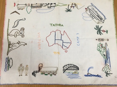
Tray Cloth, Exodus of Templers to Australia, 1942
Calico brought from Palestine and embroidered in camp 3 by 14 year old Anne Marie Treftz (now Mrs Anne Marie Reugg)Calico tray cloth, embroidered in many colours, around the 4 edges with scenes depicting the progressive exodus of the Templers from Palestine to Australia by bus, train, camel, and super liner the Queen Elizabeth. Sydney Harbour Bridge, Army personnel and unique Australian fauna. In the centre is an embroidered map of Australia. Around the map are the words: Tatura Camp 3 1942 VictoriaAround the Map of Australia- words Tatura- Camp 3- 1942- Victoriatatura, tray cloth, treftz, anne marie, palestine, kazenwadel, kurt, camp 3, reugg, templers, handcrafts, embroidery, manchester, table, linen -
Tatura Irrigation & Wartime Camps Museum
Currency - Coin, HMAS Sydney Coin, 2000
Minted by Royal Australian Mint to commemorate the distinguished service of HMAS Sydney 11Gold coloured $1 Australian coin with HMAS Sydney 11 and picture of the ship on the front and Queen Elizabeth on the back. Contained in a blue/green and cream folder. Black and white printing and picture of Sydney harbour and Bridge.coin, one dollar, hmas sydney, weppner j, tatura, ww2, numismatics, coins -
Tatura Irrigation & Wartime Camps Museum
A4 Display Book, William Skinner, 1976
Copies of Coroners' inquest, trial and other newspaper cuttings of James Edwards accused of W Skinner's murder. Sentenced to 12 years for manslaughter. Copies of additional photographs (5).Blue A4 display book, containing 22 plastic sleeves containing information of W Skinner murder 1905.murder of william skinner, waranga basin, skinners bridge, tatura-rushworth road, james edwards, victorian murder cases -
 Tatura Irrigation & Wartime Camps Museum
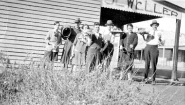
Photograph, Bluebird Cafe Proprietors
Transfer of effects from bluebird cafe to boomerang cafe east of Rly Crossing Proprietors Bridge & Nell Myersphotograph, people -
 Victorian Aboriginal Corporation for Languages
Periodical, Australian Institute of Aboriginal and Torres Strait Islander Studies, Australian Aboriginal studies : journal of the Australian Institute of Aboriginal and Torres Strait Islander Studies, 2010
Mediating conflict in the age of Native Title Peter Sutton (The University of Adelaide and South Australian Museum) Mediators have played roles in managing conflict in Aboriginal societies for a long time. This paper discusses some of the similarities and differences between older customary mediator roles and those of the modern Native Title process. Determinants of tribunal outcomes for Indigenous footballers Neil Brewer, Carla Welsh and Jenny Williams (School of Psychology, Flinders University) This paper reports on a study that examined whether football tribunal members? judgments concerning players? alleged misdemeanours on the sporting field are likely to be shaped by extra-evidential factors that disadvantage players from Indigenous backgrounds. Indigenous and non-Indigenous Australian Football League (AFL) players, matched in terms of their typical levels of confidence and demeanour in public situations, were interrogated in a mock tribunal hearing about a hypothetical incident on the football field. The specific aim was to determine if the pressures of such questioning elicited behavioural differences likely to be interpreted as indicative of testimonial unreliability. Mock tribunal members (number = 103) then made judgments about the degree to which a number of behavioural characteristics were evident in the players? testimonies. Under intense interrogation, Indigenous players were judged as presenting less confidently and displaying a greater degree of gaze aversion than non-Indigenous players. These behavioural characteristics are commonly ? and inappropriately ? used as cues or heuristics to infer testimonial accuracy. The paper discusses the implications for Indigenous players appearing at tribunal hearings ? and for the justice system more broadly. Timothy Korkanoon: A child artist at the Merri Creek Baptist Aboriginal School, Melbourne, Victoria, 1846?47 ? a new interpretation of his life and work Ian D Clark (School of Business, University of Ballarat) This paper is concerned with the Coranderrk Aboriginal artist Timothy Korkanoon. Research has uncovered more about his life before he settled at the Coranderrk station in 1863. Evidence is provided that five sketches acquired by George Augustus Robinson, the former Chief Protector of Aborigines, in November 1851 in Melbourne, and found in his papers in the State Library of New South Wales, may also be attributed to the work of the young Korkanoon when he was a student at the Merri Creek Baptist Aboriginal School from 1846 to 1847. Developing a database for Australian Indigenous kinship terminology: The AustKin project Laurent Dousset (CREDO, and CNRS, Ecole des Hautes Etudes en Sciences Sociales), Rachel Hendery (The Australian National University), Claire Bowern (Yale University), Harold Koch (The Australian National University) and Patrick McConvell (The Australian National University) In order to make Australian Indigenous kinship vocabulary from hundreds of sources comparable, searchable and accessible for research and community purposes, we have developed a database that collates these resources. The creation of such a database brings with it technical, theoretical and practical challenges, some of which also apply to other research projects that collect and compare large amounts of Australian language data, and some of which apply to any database project in the humanities or social sciences. Our project has sought to overcome these challenges by adopting a modular, object-oriented, incremental programming approach, by keeping metadata, data and analysis sharply distinguished, and through ongoing consultation between programmers, linguists and communities. In this paper we report on the challenges and solutions we have come across and the lessons that can be drawn from our experience for other social science database projects, particularly in Australia. A time for change? Indigenous heritage values and management practice in the Coorong and Lower Murray Lakes region, South Australia Lynley A Wallis (Aboriginal Environments Research Centre, The University of Queensland) and Alice C Gorman (Department of Archaeology, Flinders University) The Coorong and Lower Murray Lakes in South Australia have long been recognised under the Ramsar Convention for their natural heritage values. Less well known is the fact that this area also has high social and cultural values, encompassing the traditional lands and waters (ruwe) of the Ngarrindjeri Nation. This unique ecosystem is currently teetering on the verge of collapse, a situation arguably brought about by prolonged drought after decades of unsustainable management practices. While at the federal level there have been moves to better integrate typically disparate ?cultural? and ?natural? heritage management regimes ? thereby supporting Indigenous groups in their attempts to gain a greater voice in how their traditional country is managed ? the distance has not yet been bridged in the Coorong. Here, current management planning continues to emphasise natural heritage values, with limited practical integration of cultural values or Ngarrindjeri viewpoints. As the future of the Coorong and Lower Murray Lakes is being debated, we suggest decision makers would do well to look to the Ngarrindjeri for guidance on the integration of natural and cultural values in management regimes as a vital step towards securing the long-term ecological viability of this iconic part of Australia. Hearts and minds: Evolving understandings of chronic cardiovascular disease in Aboriginal and Torres Strait Islander populations Ernest Hunter (Queensland Health and James Cook University) Using the experience and reflections of a non-Indigenous clinician and researcher, Randolph Spargo, who has worked in remote Aboriginal Australia for more than 40 years, this paper tracks how those at the clinical coal-face thought and responded as cardiovascular and other chronic diseases emerged as new health concerns in the 1970s to become major contributors to the burden of excess ill health across Indigenous Australia. The paper cites research evidence that informed prevailing paradigms drawing primarily on work in which the clinician participated, which was undertaken in the remote Kimberley region in the north of Western Australia. Two reports, one relating to the Narcoonie quarry in the Strzelecki Desert and the other concerning problematic alcohol use in urban settings.maps, b&w photographs, colour photographs, tablesstrzelecki desert, native title, timothy korkanoon, merri creek baptist aboriginal school, austkin project, coorong, lower murray lakes district, south australia, indigenous health -
 Wonthaggi & District Historical Society
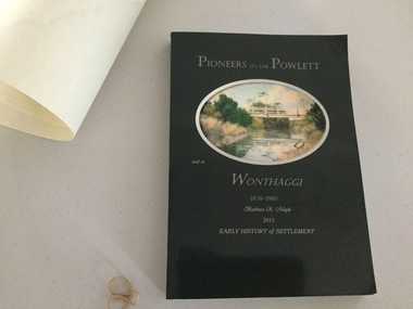
Book and Map, Barbara Moyle, Pioneers on tthe Powlett and at Wonthaggi 1878-1910, 2015
Book - families social histories, maps, photograps Map - block numbers town names physical / geographical featuresFarming and social history of pioneers of the Powlett River are prior to the establishment of the State Coal Mine at Wonthaggi. Significant land marks, buildings and photographs are included. Dark green cover with oval artists impression of Powlett river and bridge Associated map which covers the parishes plus key places of interestlPioneers on the Powlett and at Wonthaggi 1878-1910 Barbara R Moyle 2015 Early History of Settlement Map - Parish names, significant sitesfarming, pioneers of wonthaggi and district, wonthaggi families -
Swan Hill Regional Art Gallery
Print, MacFARLANE, Stewart, The Hoddle Bridge approach, 1985
... the-murray The Hoddle Bridge approach Print MacFARLANE, Stewart ... -
Koorie Heritage Trust
Document - Printed Sheets, Aboriginal Mission Station, Ramahyuck, Church Mission Reports - Ramahyuck - 1874, 1875, 1876, 1874
1874 - includes - report by Hagenauer - general progress of the mission, very evangelistic; brief reference to Aborigines living in the district, p. 2. 1875 - Includes - report by Hagenauer which is empathetic to the slow progress on behalf of the Government in relation to A?borigines; prejudice to their ritual practices and gender roles; diminishing corroborees and practice of other ritual practices in favour of Christianity; limited funding; progress towards self-determination. 1876 - includes - general progress of mission; reference to proposal to remove children and mothers and some men from the Upper Murray and place them at Ramahyuck, p. 5.4, 7 & 7 pp., 30 cm.1874 - includes - report by Hagenauer - general progress of the mission, very evangelistic; brief reference to Aborigines living in the district, p. 2. 1875 - Includes - report by Hagenauer which is empathetic to the slow progress on behalf of the Government in relation to A?borigines; prejudice to their ritual practices and gender roles; diminishing corroborees and practice of other ritual practices in favour of Christianity; limited funding; progress towards self-determination. 1876 - includes - general progress of mission; reference to proposal to remove children and mothers and some men from the Upper Murray and place them at Ramahyuck, p. 5.aboriginal mission station, ramahyuck (perry bridge, vic.) -- periodicals. | aboriginal australians -- missions -- victoria -- periodicals. -
 Rutherglen Historical Society
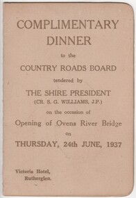
Menu and Toast List, Complimentary Dinner to the Country Roads Board, 1937 (exact)
Dinner was held at the Victoria Hotel, Rutherglen. The Shire President was Cr. S.G. Williams, J.P.Small card folder, with menu and toast list"Complimentary Dinner to the Country Roads Board tendered by the Shire President on the occasion of the opening of the Ovens River Bridge on 24th June, 1937"country roads board, ovens river bridge, opening celebration -
 Rutherglen Historical Society
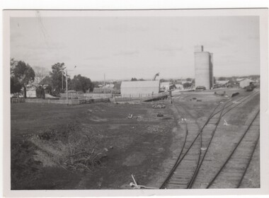
Image, 1947
Black and white photograph of Rutherglen Railway yards and silos in 1947, taken from High Street BridgeOn back of photo: "Railway Yard, Rutherglen, 1947"railway yards, silos, transport -
 Rutherglen Historical Society
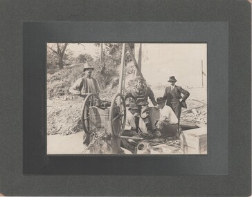
Image, c1890
Photo taken during building of 2nd John Foord Bridge, between Wahgunyah Victoria and Corowa New South Wales. Extracts from the entry for the bridge in the Victorian Heritage Database: "The bridge is of also of historical significance for its association with the prominent local identity and pioneer businessman John Foord, who was involved in the company that erected the 1862 timber bridge on the site. ... When the new bridge was built as a replacement, it took the same name." This second bridge (the current one) was opened in January 1893, Black and white photograph, mounted on cardboard, of four men, one in old style diving suit. diving, wahgunyah, corowa, john foord, bridge construction -
 Rutherglen Historical Society
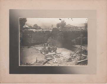
Image, c1915
Black and white photograph, mounted on cardboard, showing a group of men working on the construction of a bridge. One of the men is wearing a diving suit.Sign on building in the background: "Buffalo View Hotel"bridge construction, mount buffalo, mt buffalo, buffalo view hotel, porepunkah bridge, bridges