Showing 25210 items
matching north or new hustlers (agnew hustler)
-
 Whitehorse Historical Society Inc.
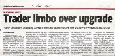
Article, North Blackburn Shopping Centre, 2017
Mr Harvey of the North Blackburn Shoe Repair is wanting to sell his business.Mr Harvey of the North Blackburn Shoe Repair is wanting to sell his business but the North Blackburn Shopping Centre will not renew his lease beyond Sep 2019 due to plans to upgrade the Centre.Mr Harvey of the North Blackburn Shoe Repair is wanting to sell his business.north blackburn square shopping centre, australian unity, north blackburn shoe repair, harvey, stewart -
 Greensborough Historical Society
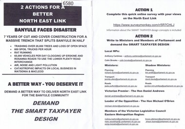
Leaflet, 2 actions for a better North East Link; with Notice of community meeting 1st August 2019, 2019_07
Criticism of current North East Link, with a notice of community meeting 1st August 2019 presenting alternative proposalsThis leaflet has no author attributed. It was letter-boxed in the Watsonia area.Leaflet about the North East Link design, with a Notice of Community Meeting north east link -
 Old Colonists' Association of Ballarat Inc.
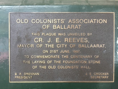
Photograph - Photograph - Colour, Centenial Plaque on the outside of the Old Colonists' Hall, Lydiard Street North, Ballarat, 21/06/1987
Plaque commemoting the centenary of the Old COlonists' Hall in Lyduard Street North, Ballarat,Old Colonists' Association of Ballarat This plaque was unveiled by Cr. J.E. Reeves, Mayor of the City of Ballaarat, on 21st June, 1987, to comemorate the centenary of the laying of the foundation stone of the Old Colonists' Hall B.R. Drennan J.E. Crocker President Secretaryold colonists' hall, j.e. reeves, b.r. drennan, j.e. crocker, centenary -
 Eltham District Historical Society Inc
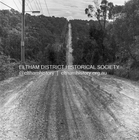
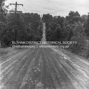
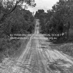
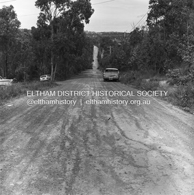
Photograph, Michael Wood, Progress Road looking west from Lower Road, Eltham North, 1976, 1976
Progress Road between Ryans Road and Lower Road, Eltham North; prior to realignment and construction, 1976Kodak Safety Film 120 format 6 x 6 cm black and white negative; 3 strips, 12 frameseltham north, lower road, progress road, road construction -
 Eltham District Historical Society Inc
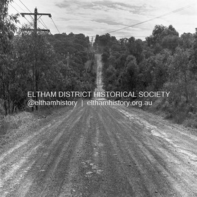
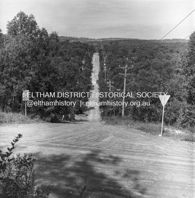
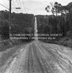
Photograph, Michael Wood, Progress Road looking west towards intersection with Ryans Road, Eltham North, 1976, 1976
Progress Road between Ryans Road and Lower Road, Eltham North; prior to realignment and construction, 1976Kodak Safety Film 120 format 6 x 6 cm black and white negative; 3 strips, 12 frameseltham north, ryans road, progress road, road construction -
 Eltham District Historical Society Inc
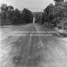
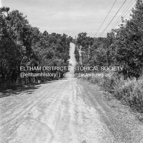
Photograph, Michael Wood, Progress Road looking east from outside No. 180, Eltham North, 1976, 1976
Progress Road between Ryans Road and Lower Road, Eltham North; prior to realignment and construction, 1976Kodak Safety Film 120 format 6 x 6 cm black and white negative; 3 strips, 12 frames Also 30 x 25 cm black and white print of this image frameeltham north, progress road, road construction -
 Eltham District Historical Society Inc
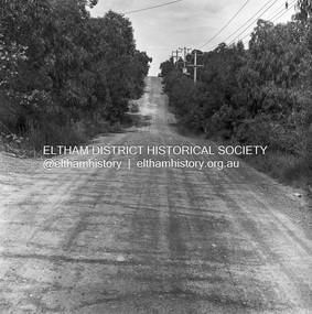
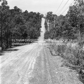
Photograph, Michael Wood, Progress Road looking west towards intersection with Ryans Road, Eltham North, 1976, 1976
Progress Road between Ryans Road and Lower Road, Eltham North; prior to realignment and construction, 1976Kodak Safety Film 120 format 6 x 6 cm black and white negative; 3 strips, 12 frames Also 30 x 25 cm black and white print of this image frameeltham north, progress road, road construction -
 Eltham District Historical Society Inc
Photograph, Michael Wood, Progress Road looking east from outside No. 180, Eltham North, 1976, 1976
Progress Road between Ryans Road and Lower Road, Eltham North; prior to realignment and construction, 1976Kodak Safety Film 120 format 6 x 6 cm black and white negative; 3 strips, 12 frameseltham north, progress road, road construction -
 Eltham District Historical Society Inc
Photograph, Michael Wood, Progress Road looking west towards intersection with Ryans Road, Eltham North, 1976, 1976
Progress Road between Ryans Road and Lower Road, Eltham North; prior to realignment and construction, 1976Kodak Safety Film 120 format 6 x 6 cm black and white negative; 3 strips, 12 frames Also 30 x 25 cm black and white print of this image frameeltham north, progress road, road construction, ryans road -
 Eltham District Historical Society Inc
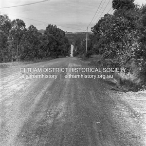
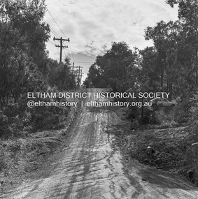
Photograph, Michael Wood, Progress Road looking east from Ryans Road, Eltham North, 1976, 1976
Progress Road between Ryans Road and Lower Road, Eltham North; prior to realignment and construction, 1976Kodak Safety Film 120 format 6 x 6 cm black and white negative; 3 strips, 12 frames Also 30 x 25 cm black and white print of this image frameeltham north, progress road, road construction, ryans road -
 Eltham District Historical Society Inc
Photograph, Michael Wood, Progress Road looking west towards intersection with Ryans Road, Eltham North, 1976, 1976
Progress Road between Ryans Road and Lower Road, Eltham North; prior to realignment and construction, 1976Kodak Safety Film 120 format 6 x 6 cm black and white negative; 3 strips, 12 frames Also 30 x 25 cm black and white print of this image frameeltham north, progress road, road construction, ryans road -
 Eltham District Historical Society Inc
Photograph, Michael Wood, Progress Road looking east from near Ryans Road, Eltham North, 1976, 1976
Progress Road between Ryans Road and Lower Road, Eltham North; prior to realignment and construction, 1976Kodak Safety Film 120 format 6 x 6 cm black and white negative; 3 strips, 12 frames Also 30 x 25 cm black and white print of this image frameeltham north, progress road, road construction, ryans road -
 Eltham District Historical Society Inc
Photograph, Michael Wood, Progress Road looking east from outside No. 180, Eltham North, 1976, 1976
Progress Road between Ryans Road and Lower Road, Eltham North; prior to realignment and construction, 1976Kodak Safety Film 120 format 6 x 6 cm black and white negative; 3 strips, 12 frames Also 30 x 25 cm black and white print of this image frameeltham north, progress road, road construction -
 Eltham District Historical Society Inc
Photograph, Michael Wood, Progress Road looking west from Lower Road, Eltham North, 1976, 1976
Progress Road between Ryans Road and Lower Road, Eltham North; prior to realignment and construction, 1976Kodak Safety Film 120 format 6 x 6 cm black and white negative; 3 strips, 12 frames Also 30 x 25 cm black and white print of this image frameeltham north, progress road, road construction, lower road -
 Eltham District Historical Society Inc
Photograph, Michael Wood, Progress Road looking east from near outside No. 196, Eltham North, 1976, 1976
Progress Road between Ryans Road and Lower Road, Eltham North; prior to realignment and construction, 1976Kodak Safety Film 120 format 6 x 6 cm black and white negative; 1 strips, 2 frameseltham north, progress road, road construction -
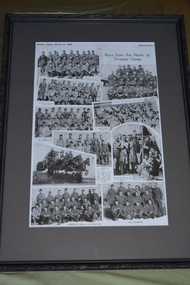 Wangaratta RSL Sub Branch
Newspaper - Framed newspaper article, Boys from the North at Torquay Camp, 16 March 1940
1940 newspaper article showing collage of photographs of soldiers from Victorian north east towns whilst at Army training camp in Torquay during World War Two.Photographs depicting soldiers who enlisted from towns in Victoria's north east whilst at training camp in Torquay prior to deployment during World War Two.Black patterned plastic frame with dark grey mount over newspaper article depicting 10 photographs of soldiersWeeklyTimes, March 16, 1940 Boys from the North at Torquay Campyarrawonga, corryong, walwa, myrtleford, moyhu, wangaratta, tallangatta, wahgunyah, tungamah, st james, wodonga -
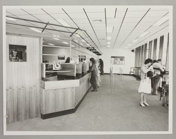 Ringwood and District Historical Society
Photograph, Interior of Ringwood North State Bank , south-east corner of Dickson's Crescent and Warrandyte Road
The new Ringwood North State Bank premises on the south-east corner of Dickson's Crescent. Showing customer service area. Opened 23 August 1982At the corner of Dickson's Cresent and Warrandyte Road, Ringwood North. Photographer - Les Gorrie Photography, 28 Waldemar Road, Heidelberg. Negative #82334 -
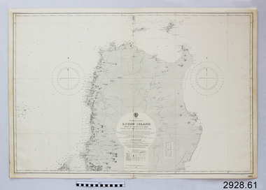
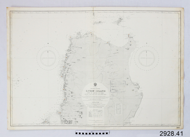 Flagstaff Hill Maritime Museum and Village
Document - Navigation Chart, Luzon Island : North of Latitude 16º 20' North
British Admiralty Navigation Chart - Luzon Island : North of Latitude 16º 20' Northwarrnambool, shipwrecked-coast, flagstaff-hill, flagstaff-hill-maritime-museum, maritime-museum, shipwreck-coast, flagstaff-hill-maritime-village, shipwrecked-artefact, navigation chart, british admiralty navigation chart, british admiralty, luzon island -
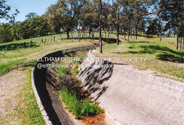
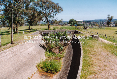 Eltham District Historical Society Inc
Photograph, Maroondah Aqueduct north of Allendale Road, Eltham North
Four colour photographs of abandoned Maroondah Aqueduct north of Allendale Road, Eltham Northaqueducts, maroondah aqueduct, allendale road, eltham north -
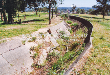
 Eltham District Historical Society Inc
Photograph, Maroondah Aqueduct north of Allendale Road, Eltham North
Four colour photographs of abandoned Maroondah Aqueduct north of Allendale Road, Eltham Northaqueducts, maroondah aqueduct, allendale road, eltham north -
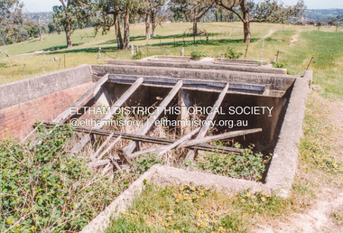
 Eltham District Historical Society Inc
Photograph, Maroondah Aqueduct north of Allendale Road, Eltham North
Four colour photographs of abandoned Maroondah Aqueduct north of Allendale Road, Eltham Northaqueducts, maroondah aqueduct, allendale road, eltham north -
 Eltham District Historical Society Inc
Photograph, Maroondah Aqueduct north of Allendale Road, Eltham North
Four colour photographs of abandoned Maroondah Aqueduct north of Allendale Road, Eltham Northaqueducts, maroondah aqueduct, allendale road, eltham north -
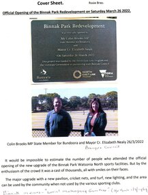 Greensborough Historical Society
Article - Article and Leaflet, Rosie Bray et al, Official opening of the Binnak Park redevelopment on Saturday March 26 2022, July 2020 , November 2021 and March 2022
An upgrade at Binnak Park Watsonia will improve facilities for the Plenty Valley Cricket Club and Watsonia Sporting Club , which have been displaced from A K Lines Reserve by construction of the North East Link, Binnak Park to continue their activities5 p. comprising 4p. North East Link "Binnak Park Community Update" 2020, with Cover sheet by Rosie Bray and colour photograph of the park at openingbinnak park, banyule parks, binnak park watsonia, north east link -
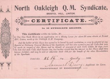 Linton and District Historical Society Inc
Share certificate, Berry Anderson & Co., Ballarat, North Oakleigh Q.M. Syndicate, Bristol Hill, Linton, 1899, 1899
Found in the loft of Bank of NSW 1980s.Beige-coloured certificate with decorative border printed on left hand side. Stamped number 8. Serrated left edge of certificate suggests it was detached from a booklet or form. Entitles the holder to one-tenth share in an application for a mining lease at Bristol Hill, Linton ("north of the Oakleigh G.M. Company"). Certificate is not made out to any person, but is signed "Samuel Devy, Applicant for Lease" and dated 26 July 1899.Text: " North Oakleigh Q.M. Syndicate, / BRISTOL HILL, LINTON. "bristol hill, north oakleigh mine, samuel devy, gold mining, mining share certificates, mining leases -
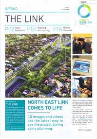 Greensborough Historical Society
Newsletter, The Link: issue 05 October 2018, Oct 2018
North East Link Authority was set up to lead development of this project. This newsletter is to keep the community informed of developments and opportunities for consultation.4 page leaflet, colour text and images.north east link -
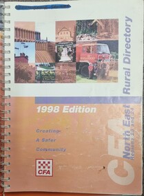 Wodonga & District Historical Society Inc
Book - North East Rural Directory 1998
The CFA North East Rural Directory for Regions 23 and 24 was designed to assist fire brigades and other emergency services in responding to calls in the North East region of Victoria. Its purpose was to minimize response times to emergency situations by providing accurate and detailed information about all of the localities in the regions. District 23 is based at Wangaratta and Extends as far south as Woods Point. District 24 is centred in Wodonga and extends past Corryong to the New South Wales border following the Murray River. It also includes Falls Creek and Mount Hotham.A spiral bound volume including colour topographic maps and illustrations of North East Victoria. The cover features a collage of colour photo of North East Victoria including a CFA firefighter in a truck with members of his family beside it. The book also features a key map, explanation of map references and symbols, localities index. Alphabetical road indexes for Wodonga, Albury, Wangaratta and Benalla as well as township maps and alphabetical road indexes for smaller communities are included.The CFA North East Rural Directory for Regions 23 and 24 was designed to assist fire brigades and other emergency services in responding to calls in the North East region of Victoria. Its purpose was to minimize response times to emergency situations by providing accurate and detailed information about all of the localities in the regions. District 23 is based at Wangaratta and Extends as far south as Woods Point. District 24 is centred in Wodonga and extends past Corryong to the New South Wales border following the Murray River. It also includes Falls Creek and Mount Hotham.emergency management north east victoria, cfa region 24, cfa wodonga, cfa region 23 -
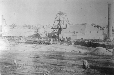 Stawell Historical Society Inc
Photograph, North Cross Reef Mine & Mining Scene 1870 -- B/W Photo & Coloured Painting
Mining Scene - North Cross Reef Co.B/W North Cross Reef with buildings, poppet heads, Tailings and wood stack with people. Two colour prints of North cross Reef. One at a different angle to B/W. Second taken further back with wood stacks, tailing dam fenced in beyond poppet heads buildings chimmney's smoking. stawell -
 Flagstaff Hill Maritime Museum and Village
Document - Navigation Chart, Luzon Island, North of Latitude 16° 20' north
British Admiralty Navigation Chart - Phillippine Islands - Luzon Island, North of Latitude 16° 20' northwarrnambool, shipwrecked-coast, flagstaff-hill, flagstaff-hill-maritime-museum, maritime-museum, shipwreck-coast, flagstaff-hill-maritime-village, shipwrecked-artefact, navigation chart, british admiralty navigation chart, british admiralty, luzon island -
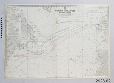 Flagstaff Hill Maritime Museum and Village
Document - Navigation Chart, North Atlantic : Route Chart showing Lane Routes North of Ireland
British Admiralty Navigation Chart - North Atlantic : Route Chart showing Lane Routes North of Irelandwarrnambool, shipwrecked-coast, flagstaff-hill, flagstaff-hill-maritime-museum, maritime-museum, shipwreck-coast, flagstaff-hill-maritime-village, shipwrecked-artefact, navigation chart, british admiralty navigation chart, british admiralty, north atlantic, route chart