Showing 599 items
matching north road station
-
 Glen Eira Historical Society
Plan - Nettalie
An A4 photocopy of the 'Plan of the Caulfield Road District' dated 1867. This plan shows the location of the properties owned by A Shaw and Blundell on Balaclava and Orrong Roads where Nettalie is situated. The plan includes all the landowners listed where their property was, the street names and other landmarks of 1867 including railways, hotels and reserves.caulfield, caulfield north, elsternwick, st kilda east, parish of prahran, parish of moorabbin, caulfield road district, melbourne and brighton railway, rosstown railway, elsternwick railway station, caulfield railway station, rosstown railway station, murrumbeena railway station, baptist church, paddy’s swamp reserve, cemetery reserve, leman swamp reserve, caulfield racecourse reserve, brighton cemetery, the vine caulfield hotel, the tam o’shanter hotel, melbourne hunt hotel, royal hotel, hotham street, horne street, nepean highway, north road, orrong road, dandenong road, princes highway, kooyong road, alma road, inkerman road, balaclava road, glen eira road, glen huntly road, hawthorn road, cemetery road, bambra road, redan road, kambrook road, neerim road, booran road, racecourse road, grange road, koornang road, murrumbeena road, crosbie road, kangaroo road, poath road, ford w, lempriere, cople j, riddell j c, manifold j, testar t, billing r h, semple, blundell, shaw a, butchart g, stephen j w, stephen g sir, hart j, duncan g, blackie r, stephen f, mccombie t, woollaston h, higgins j, lloyd j c, daish j, mcleod j, hughes d, wilson a, jamieson g, webb g h, renwick s, pennington h, dunn j, kirkpatrick w, ricketson w, toad a, sayce j, watts t, widgery, store, guess j, anketell j, clack j, sissen w, clayton g, dickson d, bevan j, hart t, anderson j, hart mrs, webb h, masters s, waghorn j, hemming c, hiam c, farquhar w, newing t, payne t, cooper r, snipe s, chambers j, forster w, summers r, harriman b, warrick, o’connell, long j, peck r, cochrane c, murray ross w, evans c, kennedy j, maclean n, forster, lyall w, dean j, newton h, looker w, baker c, johnston, crosbie j, kerr, jones, parr, nelson c, montgomery l, parsons w, james j c, sibon c, smith sydney w, plans, maps, land subdivisions, land use, settlements, roads and streets, hotels, churches, police stations, post offices, land surveys, railway stations, railways, schoolhouses, commerce, clergy residences, official buildings, local government, road districts -
Glen Eira Historical Society
Document - Nithsdale
Photocopied copy of flyer for forthcoming subdivision of Caulfield Heights Estate on 27/10/1888. Includes locality plan and subdivisions. Photocopied copy of flyer for forthcoming sale of properties and mansion, Nithsdale on 18/09/1889, includes map of area.carriages and coaches, caulfield heights estate, caulfield north, maxwell grove, kambrook road, neerim road, blake street, bambra road, racecourse road, auctioneers, station street, glen eira road, paynes j., mansion, beauchamp brothers -
Glen Eira Historical Society
Plan - Nithsdale
This file contains one item about this property: Three postcard sized photographs of a flyer for the subdivision sale of the area incorporating this property for Saturday 22/11/1924. The flyer shows photographs (black and white) and plan of the area around 'Nithsdale'.nithsdale', caulfield north, hudson street, bambra road, kambrook road, centre way, oak court, caulfield railway station, balaclava road, glenhuntly road, caulfield racecourse -
Glen Eira Historical Society
Plan - North Road, 631, Ormond
Documents concerning valuations for mortgage on the house at 631 North Road Ormond. Includes letter requesting valuation from Union Trustee Co. of Australia Ltd to W.V. Scott from Mrs. L.E. Leahy’s loan dated 08/11/1955, valuation with detailed description and plan dated 17/11/1955. Also a valuation by W.V. Scott dated 06/03/1961 for Mrs. L.E. Leahy’s mortgage.ormond, north road, brick houses, leahy lucy e., wustemann-howgate a.e., ormond station, hore f.h., union trustee company of australia ltd., australian catholic assurance co., land values -
Glen Eira Historical Society
Document - FAIRFIELD HALL, NORTH ROAD, 225, CAULFIELD SOUTH
A two page document, dated 31/05/1981, from the Brighton Historical Society, written by Rosalind Landells, about Fairfield Hall. The document provides a brief history on Fairfield Hall, describes the surrounding area, provides details of buildings architectural features, and gives information about the house’s occupants and additional details about the occupants the Younger family.fairfield hall, north road, caulfield, caulfield south, elsternwick station, gardenvale station, lantana street, begonia street, magnolia street, younger family, younger alex, norris william, landells rosalind, leadlights, curwen frederick w, hawthorn black brick, architectural features, tuck pointing, tessellated tiles, verandah, towers, rudd e w, hurley, knight c p, manala, wall harry, warrein road, wall hounsell, younger a m, younger john, kenya, younger a m mrs, campbell h a mrs, campbell hugh, younger jeanne, gardenvale, younger avenue, younger’s avenue, fairfield grove -
Glen Eira Historical Society
Letter - Glen Eira Road, 258, Elsternwick, E. K. Motors
... Everett Corner Service Station Hawthorn Road Alma Road North ...A typed letter from National Trust of Australia (Victoria) dated 04/07/1996 to E. K. Motors 258 Glen Eira Road, Elsternwick notifying that the above building built in 1935 has been classified in the National Trust’s Register, as a good example of service stations of the period. A typed copy of the National Trust Report is included.cuthbertson eric. s., klein e., tudor service station, cuthbertson sarah, klein k., petrol stations, cuthbertson eric, ek motors, e.k. motors, glover service station, swinnerton hedley fraser, glen eira road, tudor garage, glover robert, elsternwick, glover garage, architectural styles, glen huntly road, everett corner service station, hawthorn road, alma road, north caulfield, caulfield, dack and armstrong -
 Glen Eira Historical Society
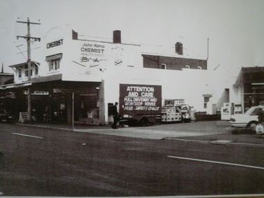
Murrumbeena
1 photograph of Shops in Murrumbeena Road, north of railway line circa 1970’smurrumbeena, murrumbeena road, shops, pharmacies, kemp, john, motor vehicle repair shops, petrol stations -
 Eltham District Historical Society Inc
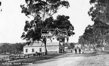
Photograph, Eltham, Main Road near station, c.1910
View looking north along Main Road, Eltham from near present day Dudley Street. On the immediate left is the railway station. The large weatherboard building on the bend (opposite present-day Arthur Street) with signs for General Store, Refreshments and Summer Drinks painted on the side is Luther and Ada Haley’s General Store and Bakery, built 1902. This was the first building in what is now Eltham’s present shopping town centre. Haley previously ran the General Store and Bakery on the corner of Main Road and York Street until his lease expired and the premises were bought by Mrs Sarah Burgoyne in 1902. The store later was known as Staff's Store. Followed by the saleyards, entrance to station, slaughter yard and William J Capewell’s butcher shop. Contained within the saleyards facing the street, a small shelter with the name H.H. Clark upon it. Horace Harold Clark was the son of Eltham State School’s first Head Teacher, David George Clark. As well as being a farmer, he was an Estate Agent and conducted auction sales, presumably from this shelter. On the eastern (right) side of Main Street is Haley’s Paddock, which was used on occasions for community picnics. Capable of holding 10,000 people, with ample shade and hilly surroundings it was an ideal place for any community gathering such as the State Schools’ Picnic in 1904. A worker from the bakery store is standing in the gateway at the rear of the store observing the photographer. People in the ‘Sunday Best’ are milling in front of the bakery or strolling down the centre of Main Road. The picture was most likely taken on a Sunday. With the opening of the railway to Eltham in 1902, Melbourne residents would regularly enjoy a Sunday excursion journey on the train to Eltham for a day’s outing to the countryside or beyond to Hurstbridge from 1912 when the railway was extended. Picture dated as c.1910 based on similar picture published in the Weekly Times, Feb. 1912. Cross Ref: 609 (looking south), 612, 611 (later stage), 613.This photo forms part of a collection of photographs gathered by the Shire of Eltham for their centenary project book,"Pioneers and Painters: 100 years of the Shire of Eltham" by Alan Marshall (1971). The collection of over 500 images is held in partnership between Eltham District Historical Society and Yarra Plenty Regional Library (Eltham Library) and is now formally known as the 'The Shire of Eltham Pioneers Photograph Collection.' It is significant in being the first community sourced collection representing the places and people of the Shire's first one hundred years.Digital image (4 x 5 inch negative missing - scanned from print) Printbaker, eltham, eltham railway station, general store, haley's paddock, luther haley, luther haley general store, main road, shire of eltham pioneers photograph collection, sign, summer drinks, butcher, railway station, w.j. capewell, eltham town centre, hot water, m.m. clark, eltham sale yards, eltham slaughter yard, staffs general store -
 Eltham District Historical Society Inc
Photograph, Tess Justine (Nillumbik Shire Council), Murray's Bridge over the Diamond Creek, Eltham North, 19 Feb 2022
Murray's Bridge over the Diamond Creek on the Diamond Creek Trail just prior to demolition and replacement with a new steel bridge. Heritage advice obtained by Nillumbik Shire Council, following a suggestion by the Eltham District Historical Society (EDHS), is that the original bridge appears to have been a simplified version of the Country Roads Board’s (CRB) standard timber bridge design of the early-to-mid 1920s. In c1990 Murray’s bridge was renovated with three recycled steel girders as part of a bike/pedestrian path in the reserve. During these alterations many parts of the bridge were removed, and some were replaced. Heritage advice indicates the condition of Murray’s bridge is poor. The remaining original parts are all in poor condition, with severe weathering, splitting and rot, especially to the stringers retained on the bridge. Heritage advice is that Murray’s Bridge does not have sufficient significance in the cultural history of the Nillumbik area to warrant inclusion in the Nillumbik Shire Heritage Overlay and also does not have sufficient significance as a rare survivor to warrant inclusion in the Nillumbik Shire Heritage Overlay. There are no indications in the historical record that this site was individually important to the cultural history of this area. EDHS is comfortable with the heritage advice provided to Council and has worked closely on this project with Council. EDHS has suggested some of the removed timbers be used in the vicinity of the bridge for landscaping and possibly seating, so as to retain these remnants close to the site of the original bridge, which is the last old timber bridge along the lower reaches of the Diamond Creek. Mary (Sweeney) Murray and John Wright Murray selected 80 acres, Lot C Section 16 and Lot 5 Section 17 Parish of Nillumbik, under an occupation license in 1866. John died in 1867 and freehold was granted to his son John in 1873. The farm was known as ‘Laurel Hill’. John Junior was an Eltham Shire councillor and sometime president from 1887 up until 1897. He added Lot A Section 16 to the farm in ca1888. John and his younger brother James arranged to rent/purchase Lot B Section 17, across Diamond Creek to the west, in ca1900. It appears that John and James farmed separately for a few years, with a new homestead built for James ad family on the high point of Lot B Section 17 in ca1910. John sold off Lot 5 Section 17 in 1912. When John died in 1912 James took over the land on both sides of the Diamond Creek. The old homestead on the west side of the Creek disappeared. A farm bridge over Diamond Creek from this period may have been located close to the northern boundary of the farm. John Langlands, owner of the farm known as ‘Ihurst’ on the west side of Diamond Creek to the south of the Murray’s land, died in 1907. In 1909 his land was then subdivided into 100 lots to become the ‘Glen Park Estate’. Other similar subdivisions of nineteenth century farms around Eltham in this period included the ‘Franktonia (or Beard’s) Estate’ to the northeast and ‘Bonsack’s Estate’ between Eltham and Greensborough. Soon after the opening of the railway extension line from Eltham to Hurstbridge in 1912, Glen Park and nearby residents including James Murray agitated for a railway station or siding to be located half-way between Eltham and Hurstbridge, so that the Glen Park residents who used the railway daily did not have to walk into the Eltham or Hurstbridge stations. Some believed Coleman’s Corner (opposite Edendale Farm) was an appropriate spot for the platform. James Murray was among those who thought the railway should be located on his land, closer to half-way between Eltham and Hurstbridge stations. The Railways Commissioners warned that the locals would have to fund these works themselves. The Glen Park Estate residents initially had difficulty accessing Eltham by road, with only an old low-level bridge over Diamond Creek at the south end of their estate. A new timber trestle bridge across the creek, now on Wattletree Road, was opened in 1915. Road access to the north was gained in 1927 when the new Murray’s Road, which crossed the Murray’s land, was built. Residents continued to agitate for a Glen Park station. By 1926 the Railways Commissioners’ preferred site was on the Murray’s land. They arranged an estimate of cost of a full-length platform. The estimate was too much for the locals, who in 1928 argued unsuccessfully for a shorter and hence cheaper platform. By 1929 Murray had agreed to donate the land, but the locals would still have to fund the works. Murray decided, unilaterally it would appear, to commence work on a timber trestle road bridge over Diamond Creek to link the new Murray Road to the proposed station. Late in 1929 he stopped work on the bridge, for reasons unknown, but started work again and completed the bridge in 1931. There is no further newspaper evidence of the campaign for the Glen Park station until 1939, when Murray and another local, Mr Maxwell, met the Railways Commissioner. The Glen Park locale now included 45 homes on the west side of the creek and 20 on the Eltham side. Most of the residents used the train every day. The Commissioner remained adamant that only a full-length platform could be built for safety reasons. It appears the campaign dissolved at this point. The increasing move to cars may have had an impact. There is no evidence of Murray’s bridge ever being connected to Murray’s Road, or of it having wide use for any purpose by locals. James Murray died in 1947 and the farm was taken over by his son James (Jim). Jim started to sell off parts of the farm in the 1980s, retaining a few acres around the ca1910 homestead and building a new house there. Recreation reserves were established along the creek. In ca1990 Murray’s bridge was renovated with steel girders as part of a bike/pedestrian path in the reserve. The old farmhouse was demolished in ca2014. * * * A theory posted on local community Facebook groups was that the bridge was built in the 1860s and was built to be more robust than was necessary for the movement of cows from one side of the creek to the other. It was suggested the robustness was necessary to support the weight of gold ore being transferred from a mine on Murray’s land to a railway siding near Murrays Bridge (presumably for transfer and processing at Diamond Creek). Perhaps this may have been one of the motivators for Murray, who really knows? Knowing when mining operations ceased on his land and how that fits the overall timeline would be useful but at the time the bridge was built, local gold production was minimal at best. The known facts are: • The railway line came to Eltham in 1902. • The extension of the railway from Eltham to Hurstbridge was constructed in 1912 so no railway line even existed through Murray's property until 1912 and the Victorian Railways maps at the time show no such siding on Murray’s property. • In 1923 a new company was formed in anticipation of the old Diamond Creek Gold Mine being re-opened. The mine had been previously closed and flooded. It was noted in the press at the time that the mine was within a mile of the railway. Nothing really came of this. • Construction of Murrays Bridge was commenced by James Murray in early 1929 in anticipation of a proposed flag station being nominated on his land, but work ceased shortly afterwards. The proposed flag station was commonly referred to as Glen Park as the residents of the Glen Park Estate wanted Option 1, located near them with the platform adjacent to Colemans corner. This was probably never going to fly as it was virtually in eyesight of Eltham station. Allandale Road was the third option, but the Commissioners' preferred option was No. 2 - on Murray's property. • The Railway Commissioners were not going to finance any such station and the works had to be funded by private landowners and residents, hence Murray investing in this himself. • Murray recommenced work two years later and finished his bridge in 1931 but unfortunately for him, the proposed flag station never eventuated. The bluestone siding you reference may well have been built by Murray as part of the proposed station platform. • Up until then, apart from the Main Road bridge, which was washed away in 1924, virtually all local crossings over the Diamond Creek were low lying bridges – Kaylocks Bridge at Brougham Street, Diamond Street bridge, Glen Park Road bridge. It is expected that Murray also had a low-lying bridge to connect his land either side of the creek. These were all washed away or severely damaged multiple times in the 1920s. Lessons were learnt, and Murrays Bridge appears to have been built in accordance with Country Road Board standards of the time. Flood damage was ongoing, and even more recently constructed raised bridges kept getting washed away, e.g., the new Wattle Tree Road bridge in 1958 just months after completion. Murray’s bridge was reinforced with steel some 30 years ago presumably to provide additional floodwater resistance, given the history of bridges disappearing in floodwaters. • In March 1932 it was reported in the Advertiser that there were still some prospectors operating around Eltham North who apart from further scarring the face of the earth over the previous two years had gained significant experience but little gold - hardly a driving factor for constructing a dedicated railway siding and bridge to transfer gold ore. It is far more probable that James Murray was hoping to have the railway station located on his property and invested his money by building the bridge to lead to it as well as a station platform. Had the station eventuated, it may well have driven up the value of his land for subdivision and new housing estates like the Glen Park Estate. That did not eventuate. Whilst the bridge was indeed old (90 years), the core structure being completed in 1931, it had been modified substantially from original and hence had no significant historic value – i.e., it was not a representative example of its type, construction, and age. Given that the bridge was not worthy of saving, the Eltham District Historical Society with Council’s support, and the Eltham Woodworkers group endeavoured to see what suitable sized timbers were salvageable to fabricate a commemorative seat. Unfortunately, the experts at the Woodworkers group were unable to salvage any suitable length/width timbers to fabricate the seat due to the presence of rot. Last remaining wooden trestle bridge on the Diamond Creek Trail just prior to demolition and replacementBorn digital image (27)diamond creek (creek), diamond creek trail, murrays bridge, ‘laurel hill’, john wright murray, mary (sweeney) murra, john murray jnr, james murray, john langlands, ‘ihurst’, ‘glen park estate’, beard's estate, franktonia, bonsack's estate, glen park estate, glen park railway station -
 Eltham District Historical Society Inc
Photograph, Tess Justine (Nillumbik Shire Council), Construction work on replacement of Murray's Bridge over the Diamond Creek, Eltham North, 31 Mar 2022
Construction work on replacement of Murray's Bridge over the Diamond Creek on the Diamond Creek Trail Mary (Sweeney) Murray and John Wright Murray selected 80 acres, Lot C Section 16 and Lot 5 Section 17 Parish of Nillumbik, under an occupation license in 1866. John died in 1867 and freehold was granted to his son John in 1873. The farm was known as ‘Laurel Hill’. John Junior was an Eltham Shire councillor and sometime president from 1887 up until 1897. He added Lot A Section 16 to the farm in ca1888. John and his younger brother James arranged to rent/purchase Lot B Section 17, across Diamond Creek to the west, in ca1900. It appears that John and James farmed separately for a few years, with a new homestead built for James ad family on the high point of Lot B Section 17 in ca1910. John sold off Lot 5 Section 17 in 1912. When John died in 1912 James took over the land on both sides of the Diamond Creek. The old homestead on the west side of the Creek disappeared. A farm bridge over Diamond Creek from this period may have been located close to the northern boundary of the farm. John Langlands, owner of the farm known as ‘Ihurst’ on the west side of Diamond Creek to the south of the Murray’s land, died in 1907. In 1909 his land was then subdivided into 100 lots to become the ‘Glen Park Estate’. Other similar subdivisions of nineteenth century farms around Eltham in this period included the ‘Franktonia (or Beard’s) Estate’ to the northeast and ‘Bonsack’s Estate’ between Eltham and Greensborough. Soon after the opening of the railway extension line from Eltham to Hurstbridge in 1912, Glen Park and nearby residents including James Murray agitated for a railway station or siding to be located half-way between Eltham and Hurstbridge, so that the Glen Park residents who used the railway daily did not have to walk into the Eltham or Hurstbridge stations. Some believed Coleman’s Corner (opposite Edendale Farm) was an appropriate spot for the platform. James Murray was among those who thought the railway should be located on his land, closer to half-way between Eltham and Hurstbridge stations. The Railways Commissioners warned that the locals would have to fund these works themselves. The Glen Park Estate residents initially had difficulty accessing Eltham by road, with only an old low-level bridge over Diamond Creek at the south end of their estate. A new timber trestle bridge across the creek, now on Wattletree Road, was opened in 1915. Road access to the north was gained in 1927 when the new Murray’s Road, which crossed the Murray’s land, was built. Residents continued to agitate for a Glen Park station. By 1926 the Railways Commissioners’ preferred site was on the Murray’s land. They arranged an estimate of cost of a full-length platform. The estimate was too much for the locals, who in 1928 argued unsuccessfully for a shorter and hence cheaper platform. By 1929 Murray had agreed to donate the land, but the locals would still have to fund the works. Murray decided, unilaterally it would appear, to commence work on a timber trestle road bridge over Diamond Creek to link the new Murray Road to the proposed station. Late in 1929 he stopped work on the bridge, for reasons unknown, but started work again and completed the bridge in 1931. There is no further newspaper evidence of the campaign for the Glen Park station until 1939, when Murray and another local, Mr Maxwell, met the Railways Commissioner. The Glen Park locale now included 45 homes on the west side of the creek and 20 on the Eltham side. Most of the residents used the train every day. The Commissioner remained adamant that only a full-length platform could be built for safety reasons. It appears the campaign dissolved at this point. The increasing move to cars may have had an impact. There is no evidence of Murray’s bridge ever being connected to Murray’s Road, or of it having wide use for any purpose by locals. James Murray died in 1947 and the farm was taken over by his son James (Jim). Jim started to sell off parts of the farm in the 1980s, retaining a few acres around the ca1910 homestead and building a new house there. Recreation reserves were established along the creek. In ca1990 Murray’s bridge was renovated with steel girders as part of a bike/pedestrian path in the reserve. The old farmhouse was demolished in ca2014. Born digital image (5)diamond creek (creek), diamond creek trail, murrays bridge, ‘laurel hill’, john wright murray, mary (sweeney) murra, john murray jnr, james murray, john langlands, ‘ihurst’, ‘glen park estate’, beard's estate, franktonia, bonsack's estate, glen park estate, glen park railway station -
 Eltham District Historical Society Inc
Photograph, Jim Connor, Avenue of Honour, Main Road, Eltham, 14 Jan 2017
Eltham Gateway, View looking north to intersection of Brougham Street from near 725 Main Road - replica former Police Station at Local History CentreTomorrow's history documented todayeltham, jim connor collection, main road, eltham gateway, avenue of honour, brougham steet, local history centre -
 Eltham District Historical Society Inc
Photograph, Former Eltham Police Residence, 728 Main Road, Eltham, c.1985, 1985c
This photo is believed to have been taken circa 1985 when the Shire of Eltham Parks and Environment occupied the site. This photo was originally mounted on 3mm MDF fibre board with notes and stickers applied as part of a display on the former Police Residence and now present day Local History Centre, home to Eltham District Historical Society; possibly put together by Harry Gilham during his time as president of the society. Eltham Police Station and Residence: A brief history 1860 Eltham Courthouse built in Main Road, together with an adjoining police residence, office, lock–up and stables. 1959 Police Department purchases a house in Pryor Street to be refurbished as Eltham Police Station 1961 Police in Eltham move into Pryor Street refurbished buildings and office. c.1961-1981 Occupied by Vermin and Noxious Weeds Destruction Section of the Department of Crown Lands and Survey. Former Police Station dragged around to rear of Police Residence (prior to August 1967) to make way for the construction of a driveway and access from Main Road. The building was placed on the site of a former Scullery and modified for Lands Department use. 1981 Shire of Eltham take over management of old Police Residence in Eltham. It remains unoccupied for a period of time whilst its future is discussed in Council. 1981-1985 Used for community job creation scheme 1985 Shire of Eltham Parks and Environment occupy the residence. Council improve the driveway but later add a second rear access from Brougham Street due to the dangerous nature of the Main Road entrance. Also add a rear toilet facility between the Police Residence and former Police Station, which was doubling up as a lunch room. Council also commence discussions to re-establish a replica Police Station. c.1986 November. Former Police Station demolished; believed to have been suffering termite damage. c.1989 After some years of discussion a replica Police Station is built, based on photographs, to act as a lunch room and meeting room for Parks and Environment staff and volunteers doing community service. 1996 Eltham District Historical Society in discussions with Nillumbik Shire Council commisioners throughout the year regarding a home for the Society. A proposal put forward by the Society in October to occupy the former Police Residence. 1997 March. Eltham District Historical Society gains access to former Police Residence. 1998 July 12th. Eltham District Historical Society Inc moves into its Local History Centre, 728 Main Road Eltham (the former Police Residnce built in 1860). 2018 July. Eltham District Historical Society gains access to the replica Police Station for use as part of regular heritage tours for schools and community based groups.Colour printHandwritten in faded blue felt pen ink "Another view of north wall 728 No. 4. Taken from west end towards back yard"728 main road, eltham, local history centre, parks and environment, police residence, police station, shire of eltham -
 Eltham District Historical Society Inc
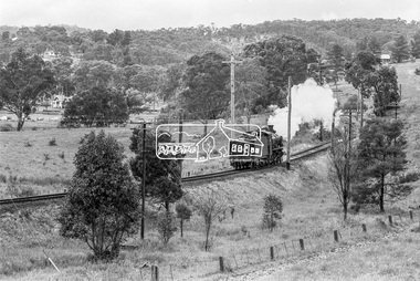
Photograph, Steam locomotive D-639 Vintage train excursion, Hurstbridge to Eltham, near Wattletree Road, Eltham North, c.1970, 1970
View appears to be from near Coolabah Drive looking northwest across parts of Edendale Farm and to the oval near the present day Adventure Playground and Wattletree Road. Possibly run in conjunction with the Eltham Community Festival or the Hurstbridge Wattle Festival; the steam train would conduct trips between Eltham and Hurstbridge Railway stations. As there is no turning table at Hurstbridge, the locomotive would simply shunt from one end of the carriages to the other to reverse direction, hence the locomotive is running in reverse as it approaches Eltham Station.Digital TIFF file Scan of 35mm Ilford HP4 black and white transparencyd-639, edendale farm, eltham festival, eltham north, eltham north adventure playground, george coop collection, hurstbridge wattle festival, steam engine, vintage train excursion, wattletree road -
 Eltham District Historical Society Inc
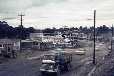
Photograph, Roadworks, Main Road widening, Eltham, 15 July 1968, 1968
Looking north from near Dudley Street towards shopping strip35mm Colour positive transparency Mount - Agfacolor Service (Blue stepped)arthur street, bp service station, dudley street, duplication, eltham, eltham fire brigade, eltham war memorial, fire station, main road, road construction, war memorial gates -
 Eltham District Historical Society Inc
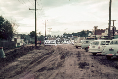
Photograph, Roadworks, Main Road widening, Eltham, 15 July 1968, 1968
Looking north from near Dudley Street towards shopping strip35mm Colour positive transparency Mount - Agfacolor Service (Blue stepped)bp service station, duplication, eltham, eltham fire brigade, fire station, main road, road construction -
 Eltham District Historical Society Inc
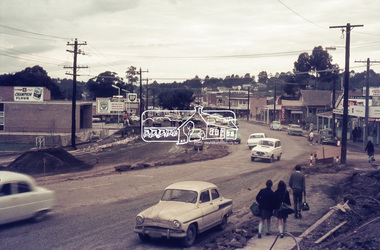
Photograph, Roadworks, Main Road widening, Eltham, c.15 July 1968, 1968
Looking north from near Dudley Street towards shopping strip35mm Colour positive transparency Mount - Agfacolor Service (Blue stepped)arthur street, bp service station, duplication, eltham, eltham fire brigade, fire station, main road, road construction -
 Eltham District Historical Society Inc
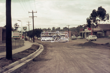
Photograph, Roadworks, Main Road widening, Eltham, c.15 July 1968, 1968
Looking north from opposite Pryor Street. Sign to Police Station on telegraph pole35mm Colour positive transparency Mount - Agfacolor Service (Blue stepped)caltex service station, duplication, main road, petrol bowser, police station, pryor street -
 Greensborough Historical Society
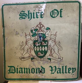
Sign - Boundary Sign, Shire of Diamond Valley, Shire of Diamond Valley boundary sign, 1990s
... ; at Yan Yean Road north of Bannons Lane; 2 on Plenty Road near... Glen Station; at Yan Yean Road north of Bannons Lane; 2 ...The Shire of Diamond Valley was a Local Government Area located about 20 kilometres northeast of Melbourne. The shire covered an area of 74.38 square kilometres and existed from 1964 until 1994. This example of a Boundary Sign was one of many located on the edge of the Shire e.g. at Wattle Glen Station; at Yan Yean Road north of Bannons Lane; 2 on Plenty Road near Larundel and Bundoora Primary School; one on the Para Road bridge; on Wattletree Road Eltham and on Kurrak Road Yarrambat. According to a former Shire employee, the signs were often stolen as quickly as they were replaced. This sign was removed when the Shire of Diamond Valley was dissolved in 1994 and is signed by a Shire employee, giving it strong provenance.Painted metal sign, cream background with green text and Shire of Diamond Valley crest.Inscribed in felt tip pen on back of sign: SDV: from Nov 1964 to 1994. 30 years. Ron Middleton, By-laws Officer and Ranger, from 9/84 to Nov 94 [signed] R. Middletonshire of diamond valley, boundary signs -
 Greensborough Historical Society
Map, Melbourne and Metropolitan Board of Works. Survey Division, MMBW, Yarra 2500 / 12.22. Watsonia North, 1978_03
Melbourne and Metropolitan Board of Works. Yarra 2500 [base map]. 12-22, Parishes of Keelbundora 2856, Municipalities of Whittlesea 239 and Diamond Valley 257. Shows street names, easement sizes, lot numbers, lodged plan numbers, names of prominent features, contour values, creek or river names. Watsonia Railway Station and environs. Prominent streets: Edmund Rice Parade and Macorna Street. Includes Christian Brothers Edmund Rice College and Janefield Special School sites and "proposed future freeway" (now Metropolitan Ring Road).MMBW Map in 1:2500 [scale] series. Cream parchment with green tape reinforcing on edges and punched holes on left edge.mmbw, melbourne and metropolitan board of works, shire of diamond valley, watsonia - maps, bundoora - maps -
 Greensborough Historical Society
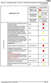
Document, Advocacy list (North East Link), 05/08/2019
Attachment to Item 5.6, Ordinary meeting of Council 5 August 2019, discussing the North East Link and possible impacts on the City of Banyule, including Watsonia.5 pages, typescriptnorth east link, watsonia station, watsonia -
 Greensborough Historical Society
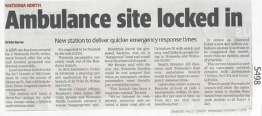
Newspaper Clipping, Diamond Valley Leader, Ambulance site locked in, 07/11/2018
A new site has been secured for a Watsonia North ambulance branch after the original location proposed was deemed unsuitable.News article 1 page, black text.watsonia north, ambulance station, grimshaw street watsonia -
 Greensborough Historical Society
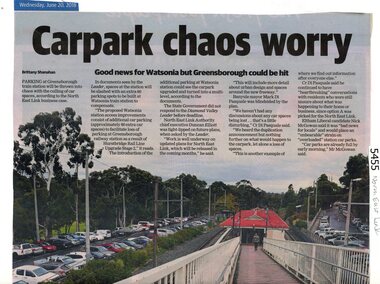
Article - Newspaper Clipping, Diamond Valley Leader, Carpark Chaos worry, 20/06/2018
Parking at Greensborough train station will be thrown into chaos with the culling of car spaces, according to the North East Link business case.News article 1 page, black text and colour image .north east link, car parking chaos, greensborough station -
 Greensborough Historical Society
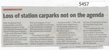
Newspaper Clipping, Diamond Valley Leader, Loss of station carparks not on the agenda, 27/06/2018
The North East Link Authority has botched business case documents that claimed Greensborough station would lose carparks.News article 1 page, black text.north east link, car parking, greensborough station, watsonia station -
 Greensborough Historical Society
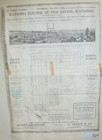
Advertising Leaflet, Knight & Harwood, Electric Station Estate, Watsonia, 19/07/1924
Photocopy of auction leaflet for land north of Watsonia Railway Station, Saturday 19th July 1924. Auctioneer Knight & Harwood.Photocopy of auction leaflet 1 p.watsonia, watsonia electric station estate -
 Greensborough Historical Society
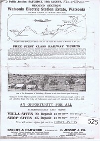
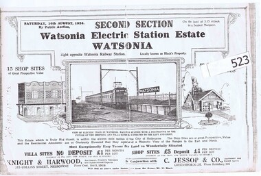
Advertising Leaflet, Knight & Harwood, Electric Station Estate, Second Section, Watsonia, 16/08/1924
Photocopy of auction leaflet for sale of second section of land north of Watsonia Railway Station, Saturday 16th August 1924. Auctioneer Knight & Harwood in conjunction with C. Jessop.Photocopy of auction leaflet 1 p.watsonia, watsonia electric station estate -
 Greensborough Historical Society
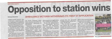
Newspaper clipping, Opposition to station wins, 01/07/2015
Ambulance Victoria has withdrawn its application to build a new branch in Trist Street Watsonia North following community concerns.News clipping, black text, colour image.trist street watsonia north, ambulance victoria -
 Greensborough Historical Society
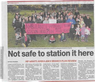
Newspaper clipping, Not safe to station it here, 17/06/2015
Ambulance Victoria's plans to build a new station at Trist Street Watsonia North are to be reviewed, following residents' objections.News clipping, black text, colour image.ambulance victoria, trist street watsonia north -
Greensborough Historical Society
Article, Ian Lamont, An early history of Plenty Valley FM Radio 1987-1998, 1987o
Plenty Valley FM made its first test broadcast in July 1988, then known as Outer North Eastern Community Radio. After obtaining its broadcasting licence, regular broadcasts commenced in December 1990. The author of this article, Ian Lamont, was first Station President (1987-91) and first Station Manager (1993-98).3 pages text and one photo.plenty valley community radio, plenty valley fm, ian lamont -
 Greensborough Historical Society
Advertising Leaflet, Knight & Harwood, Electric Station Estate, Second Section, Watsonia, 16/08/1924
Auction leaflet (copy) for sale of second section of land north of Watsonia Railway Station, Saturday 16th August 1924. Auctioneer Knight & Harwood in conjunction with C. Jessop.Photocopy of auction leaflet 1 p.watsonia railway station estate, watsonia -
Greensborough Historical Society
DVD, Channel 5 Productions et al, The Inner Circle Railway Line, 1888o
The Inner Circle was a steam era suburban railway line (later electrified) in Melbourne, Australia. It served the inner-northern suburbs of Parkville, Carlton North, Fitzroy North, and Fitzroy and later expanded to outer suburbs. It opened in 1888. In this video, the viewer is taken on a train journey around the Melbourne rail network and also looks at the stations and lines that have since closed.Original footage of Melbourne's railways.1 x DVD in black case. DVD of approx 43 minutes.melbourne rail network, transportation, railways