Showing 294 items
matching skyline
-
 Hume City Civic Collection
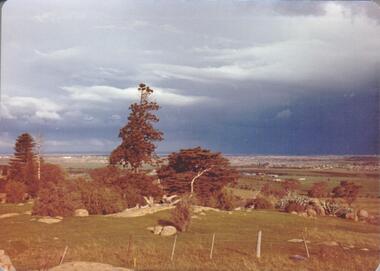
Photograph, September 1994
Woodlands Park complex which includes 'Cumberland' and 'Dundonald' ruins and the Gellibrand Hill Quarries was acquired by the Victorian State Government in 1978 and is managed by Parks Victoria.A view taken from Gellibrand Hill looking east towards the developing suburb of Greenvale. There are small rocky outcrops in the foreground and a clump of conifers and cypress trees in the middle. The sky is very overcast and a range of mountains can be seen across the skyline. Coloured photograph with rounded corners and matt finish.woodlands park, gellibrand hill, greene, william pomeroy, anne, george evans collection -
 Bendigo Historical Society Inc.
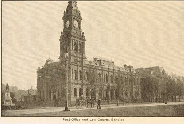
Photograph - POST OFFICE AND LAW COURTS, BENDIGO
Sepia post card, printed on back 'Post Card, printed in Australia, R.E.M. Series' Image shows Post Office and Law Courts, Pall mall Bendigo. Horse and cart in front of image, lamp post on Lh side. Camp Hill primary school just visible on skyline at rear.place, streetscape, pall mall, bendigo, law courts, post office, pall mall. -
 Port Melbourne Historical & Preservation Society
Photograph - Parking area, London Hotel, Swallow & Ariell and city skyline, Development of TT Lines truck parking area, Station Pier, Port Melbourne, 1992
Thirteen (13) colour photographs taken by Lyn Allison as part of Bayside Development Action Group. Photos show the development of TT Line's truck parking area at Station Pier in 1992. .06 - truck parking area, London Hotel, Swallow and Ariell and city skyline in background also pilingspiers and wharves - station pier, tt-line co pty ltd, abel tasman, beacon, station pier gatehouse, london family hotel, swallow & ariell ltd -
 Falls Creek Historical Society
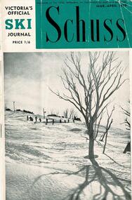
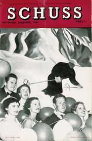
Journal - Schuss Vol. 25. No 2 March- April 1959
Schuss was advertised as Victoria’s Official Ski Journal It was issued monthly from 1935 to 1961 except during the war when summer issues covered two months. This continued after the war, but it averaged 10 issues annually over its 25 year life. Schuss was published by the Ski Club of Victoria which had a membership of 38 Ski Clubs and demanded to be recognised as the prime authority on skiing in the state. The other 30 ski clubs with 85% of the members disagreed and the politics of skiing became heated. These clubs formed the Federation of Victorian Ski Clubs with their own journal, Ski Horizon. With the establishment of the Victorian Ski Association, Ski-Horizon published its last issue in Nov - Dec. 1955 and the role of the official journal was fully taken over by “Schuss”. This item is significant because it contains stories, images and information documenting the development of the ski facilities at Falls Creek.The journal features stories and events chronicling developments in Victoria and internationally. The cover shows a group of skiers descending the slopes. Page 61 described work that had been carried out at Skyline Lodge reading for the coming season. Page 64 included an advertisement for exclusive accommodation at Snow Crystal Inn.schuss journal, skyline lodge, snow crystal inn -
 Eltham District Historical Society Inc
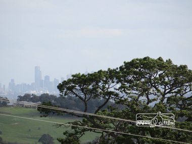
Photograph, Liz Pidgeon, View of Melbourne from the Moor-rul viewing platform at the War Memorial Park at Kangaroo Ground, 10 August 2016
View of Melbourne from the Moor-rul viewing platform at the War Memorial Park at Kangaroo Ground. As part of a program to acknowledge the Anzac Centenary Nillumbik Shire Council partnered with Yarra Plenty Regional Library to provide a bus tour with commentary of local sites of significance. These included Eltham township, the Shire of Eltham War Memorial at Kangaroo Ground, Christmas Hills war memorial, Hurstbridge memorial recreation park and finshed at Eltham Library to view the Writing the War exhibtion at Eltham Library Community Gallery. Born Digitalwar memorials, shire of nillumbik, kangaroo ground, moor-rul viewing platform, melbourne, skyline, view -
 Falls Creek Historical Society
Journal - Schuss Vol. 20. No. 8 November - December 1954
Schuss was advertised as Victoria’s Official Ski Journal It was issued monthly from 1935 to 1961 except during the war when summer issues covered two months. This continued after the war, but it averaged 10 issues annually over its 25 year life. Schuss was published by the Ski Club of Victoria which had a membership of 38 Ski Clubs and demanded to be recognised as the prime authority on skiing in the state. The other 30 ski clubs with 85% of the members disagreed and the politics of skiing became heated. These clubs formed the Federation of Victorian Ski Clubs with their own journal, Ski Horizon. With the establishment of the Victorian Ski Association, Ski-Horizon published its last issue in Nov - Dec. 1955 and the role of the official journal was fully taken over by “Schuss”. This item is significant because it contains stories, images and information documenting the development of the ski industry in Victoria.The journal features stories and events chronicling developments in Victoria and internationally. Items related to the Falls Creek Area in this issue include:- Page 260 - Summer at Falls Creek and Skyline - ARE you visiting Falls Creek during the summer months? Then don't forget to arrange through the Club office for a permit from the State Electricity Commission to use the Kiewa Road. And while at the office study the copy of the Commission's Kiewa Regulations which will be found on the notice board. We are sure that you will enjoy a stay at Skyline Lodge and a visit to the delightful terrain of Falls Creek and the High Plains equally well in summer as in winter; and the S.E.C. requirements are easy for members to comply with. Page 269 photo by L.J.Clarke - on the Frying Pan Spurschuss journal, summer regulations on the high plain, frying pan spur -
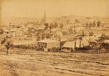
 Bendigo Historical Society Inc.
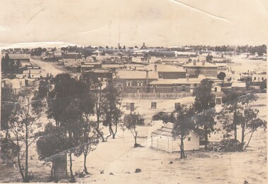
Photograph - HARRY BIGGS COLLECTION: LOOKING SOUTH AT EAGLEHAWK, c1875
Photograph. Harry Biggs Collection. 3 black & white photos looking south at Eaglehawk. Circa 1875. Photographer Caire. An overview of the City of Eaglehawk. Town Hall Hotel can be seen in the distance. The word Drapers is to the left. Trees are in the foreground. Eaglehawk State School is on the skyline (tall building with the bell tower).Caire.photograph, streetscape, eaglehawk, harry biggs collection, looking south at eaglehawk, eaglehawk state school, town hall hotel, eaglehawk town hall, eaglehawk post office -
 Melbourne Legacy
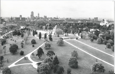
Photograph, Shrine of Remembrance, 1973
A photo of the Shrine, it shows the Melbourne skyline and the gardens from an elevated position. It was used on the cover of the programme for the annual "Anzac Commemoration Ceremony for Students" in 1973. It was used for several years afterwards as well. The student events were usually held just prior to ANZAC Day.The Shrine is an imposing building in the Melbourne skyline. Images like this were used by Legacy on the cover of their school students' Anzac service programmes.Black and white photo of an aerial view of the Shrine of Remembrance and a strip of negatives.shrine of remembrance, garden -
 Melbourne Tram Museum
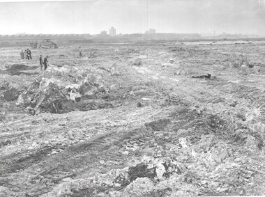
Photograph - Set of 11 Black & White Photograph/s, Melbourne & Metropolitan Tramways Board (MMTB), 1964
Series of 9 black and white photographs of the construction of the new bus depot at Doncaster c1964. Items .1 to .9 show the earthworks, nearby factories and skylines. The style of the equipment used at the time is shown. Has a Craven A billboard. Items 10 and 11 are two sheets of paper giving details and some captions for the photographs.trams, tramways, buses, doncaster depot, construction, contracts -
 Clunes Museum
Photograph, C 1865
.1 PHOTOGRAPH - ORIGINAL SEPIA - OF PORT PHILLIP AND COLONIAL GOLD MINE, CLUNES, POPPET HEAD ON SKYLINE. .2 SEPIA PRINT OF PHOTOGRAPH .3 PHOTOCOPY OF A LITHOGRAPH OF THIS PHOTOGRAPH .4 BLACK AND WHITE COPY .5 MOUNTED BLACK AND WHITE COPY .6 BLACK AND WHITE COPY .7 BLACK AND WHITE COPY PORT PHILLIP AND COLONIAL MINING COMPANY, CLUNES. GENERAL VIEW, MINE AND WORKS. C. NETTLETON, PHOTO MELBOURNE.local history, photography, photographs, mining -
 Ballarat Tramway Museum
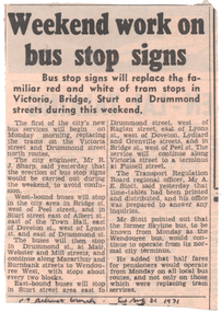
Newspaper, The Courier Ballarat, "Weekend work on bus stop signs", 14/8/1971
Newspaper item about the installation of new bus stops and signs following the closure of the Victoria St tram line that Sunday. Quotes Mr Sharp City Engineer and Mr A Stott of the TRB about the new services and notes that the Skyline Wendouree Bus city stop would be unchanged.Yields information about the closure of the SEC operated tram system and changed car parking.Newspaper cutting from The Courier 21/8/1971tramways, closure, ballarat, bridge st, car parking, bus stops, victoria st. -
 Bendigo Military Museum
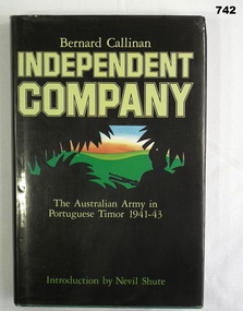
Book, William Heinemann, Independent Company The Australian Army in Portuguese Timor 1941-43, 1984
Documents the role of the Australian Army in Portuguese Timor from 1941-43. Introduction written by Nevil Shute.235 page green hardcover book with gold title on spine. Dust cover is black with silhouette of soldier and leaves against green hills and orange and blue skyline. Pages edges are cut, inside front cover has map of SE Asia and inside back cover has map of Timor. Includes maps and B&W illustrations.Printed sticker inside front cover "From Bishop Daly's collection 2004" On title page "+ N D Daly, Bendigo. January 1986"books, military history, timor -
 Bendigo Historical Society Inc.
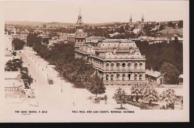
Postcard - PALL MALL AND LAW COURTS, BENDIGO, VICTORIA
Postcard :image shows Law Courts on RH side, looking south towards City Family Hotel, tram in centre of Pall Mall, no cars. Palm trees in foreground in park, horse and trap in foreground. Spires of churches in View Street in skyline. On bottom: The Rose Series P 3213, Pall Mall and Law Courts, Bendigo Victoria.bendigo, streetscape, pall mall, bendigo, pall mall, law courts -
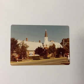
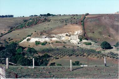 Hume City Civic Collection
Photograph, c Early 1990's
The Kaolin quarries at Bulla were an important industry in the district and supplied clay products to the Cornwell and Hoffman companies in Brunswick. The Kaolin deposits were found in the 1850's and were considered to be some of the largest in the colony.A landscape photograph of a valley with a post and wire fence and a partial view of a farm gate in the immediate foreground. A clump of native trees are on the LHS and a small grove of almond trees has been planted on the river flat. Kaolin quarry is on the hillside and two buildings can be seen on the hill top. High tension pylons are in the distance near the skyline.kaolin quarries, almond groves, bulla township, deep creek, hoffmans kaolin mine, hoffmans potteries, cornwell potteries, george evans collection -
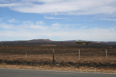 Sunbury Family History and Heritage Society Inc.
Photograph, Rosa McCall, Riddell Road, February 2014
In February 2014 severe grassfires blazed across the land north of Sunbury from the Calder Highway across Riddell Road and on to Clarkefield and beyond and caused damage to the Bendigo Railway line. This image was taken about a week later along Riddell Road and looking SW to Red Rock across the skyline.This grass fire caused much damage across a large area north of Sunbury and beyond.A coloured photograph of an open landscape that has been extensively burnt after grassfires.grass fires, riddell road, red rock, sunbury -
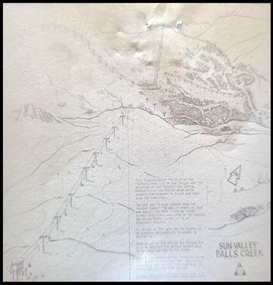 Falls Creek Historical Society
Map - Sun Valley, Falls Creek, 1966
This hand drawn map shows the Gully Chair, Summit Tow and the Village Tow. It also highlights the Nursery Poma. Several buildings can be seen along with the Visitor Centre in the Gully carpark, Skyline can can be seen adjacent to the Gully Chair. The Sun Valley T-Bar was designed by Ron McCallum and began operation in 1967. It had a length of 826 metres and an elevation of approximately 200 metres. In 1989 the Sun Valley T-Bar was replaced by the Scott Quad. Ron McCallum was a founder of Alpine Developments. It appears that his first lift was the Skyline portable tow at Falls Creek in 1954. As an engineer, he went on to build about 20 chairlifts and T-bars in the 1960s and early 1970s including at least five at Falls Creek. This map is significant because it shows plans for the development of a major tow at Falls Creek in the 1960s.A framed black and white concept map for the proposed new lift in Sun Valley, Falls Creek.sun valley tow, ron mccallum, falls creek tows -
 Eltham District Historical Society Inc
Photograph, View of Kangaroo Ground, 10 August 2016
View of Kangaroo Ground from the Moor rul Viewing Platform. As part of a program to acknowledge the Anzac Centenary Nillumbik Shire Council partnered with Yarra Plenty Regional Library to provide a bus tour with commentary of local sites of significance. These included Eltham township, the Shire of Eltham War Memorial at Kangaroo Ground, Christmas Hills war memorial, Hurstbridge memorial recreation park and finshed at Eltham Library to view the Writing the War exhibtion at Eltham Library Community Gallery. View of Melbourne from the Moor-rul viewing platform at War memorial park Kangaroo Ground, Garden Hill. Born Digitalwar memorials, shire of nillumbik, kangaroo ground, view, skyline, melbourne, moor-rul viewing platform, garden hill -
 Bendigo Art Gallery
Photograph - Work on paper, Nicholas CAIRE, View of the Golden Square Township, 1875
l.l; N.J.Caireaustralian photographer, albumen, bendigo, golden square, sandhurst, town, city, skyline -
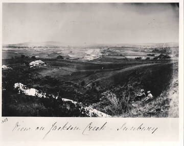 Hume City Civic Collection
Photograph - View of Jackson Creek Sunbury, c1870
The photograph was taken on a rise overlooking the early settlement of Sunbury with Mount Holden and other hills across the skyline. The five arch railway bridge is visible in the distance on the RHS of the image. Two of Sunbury's early hotels, the John Franklin and the Ball Court are across the middle distance. Craiglee Vineyard with the vines growing is in the foreground. A black and white photograph with a white border.Written across the bottom: VIEW OF JACKSON CREEK SUNBURYsunbury, vineyards, jackson creek, craiglee vineyard -
 City of Kingston
Photograph - Black and white, Percy Fairlam, c. 1910
Black and white image of Cheltenham in the early 20th Century depicts an almost idyllic life. This photo was taken by Percy Fairlam, who climbed a tall pine tree to achieve the aerial view. The tree was a well recognised feature of the Cheltenham skyline but was cut down some time before World War II.Cheltenham was established as a rural market gardening community. The development of the railway was crucial to the ongoing development of the area. Community life sprung up around the railway line which is evident in the proximity of shopping and leisure.Black and white image depicting aerial view down Charman Road, Cheltenham, including the unsealed road, level crossing and shopping centre. What appears to be a cricket pitch is located behind the shops.Handwritten in black ink on a red round sticker adhered to the reverse, and then crossed out: X14 Handwritten in blue ink on reverse: A8 Handwritten in red ink on reverse: 85%cheltenham, railway crossing, roads, housing, shopping strip -
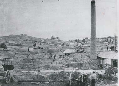 Bendigo Historical Society Inc.
Photograph - MINING LANDSCAPE, 1861
black and white photograph: view of mining area. From left to right, portion of cart, hut, houses and huts, whims, small houses, houses on skyline. Tall brick chimney at right with wood and corrugated iron roof buildings. 2 carts at front right. 2 males front right. Small houses at background right. Location unknown.batchelderplace, landscape view, mining -
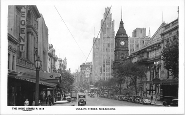 Melbourne Tram Museum
Postcard, Rose Stereograph Co, "Collins Street Melbourne", late 1930s
Rose Series postcard No. P 1518, titled "Collins Street Melbourne", with the nearly completed Manchester Unity Building 1932 dominating the skyline behind the Town Hall on the corner of Swanston Street. On the left is the Regent Theater and "Misses Mooney" a famous ladies fashion label of 189 Collins Street for decades, run by Nell & Ida Mooney. Yields information about Collins St mid 1930s.Postcard - printed real photograph with Rose Stereograph Co. name on the rear.tramways, trams, collins st -
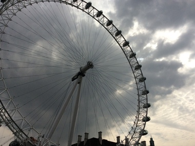 Ballarat Heritage Services
Digital photograph, Dorothy Wickham, The London Eye, 2016, 19/09/2016
At 135m, Coca-Cola London Eye is the world’s largest cantilevered observation wheel. It was conceived and designed by Marks Barfield Architects and was launched in 2000. It has won over 85 awards for national and international tourism, outstanding architectural quality and engineering achievement. In fact, it has become the UK’s most popular paid for visitor attraction. A remarkable feat of design and engineering, the London Eye gave London’s skyline a dramatic new addition and has been offering guests a new perspective on London ever since. Originally, it was intended as a temporary structure, able to be dismantled and transported to a new location, and had planning permission for just five years. But with millions boarding it every year, its popularity has prompted its lease to be extended. Today it is a permanent fixture on the London skyline and a beautiful symbol of modern London. (https://www.londoneye.com/about-us/#sthash.Xxd6iuOj.dpuf)london eye, ferris wheel -
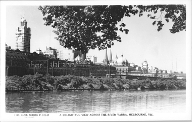 Melbourne Tram Museum
Postcard, Rose Stereograph Co, "A delightful view across the River Yarra, Melbourne"
Rose Series postcard No. P 10147, titled "A delightful view across the River Yarra, Melbourne" showing a view from the south bank of the Yarra across to Flinders St station, the signal gantries at the west end of the platforms, the station buildings and some of the other buildings on the skyline. A St Kilda bound dog box (swing door) set is in platform 10 awaiting departure.Yields information Flinders St station from the south side of the river.Postcard - printed real photograph with Rose Stereograph Co. name on the rear.flinders st station, signals, yarra river, railways, electric trains -
 Mt Dandenong & District Historical Society Inc.
Photograph, View from 'Forest Edge', 1973
Photograph taken in 1973 from the property 'Forest Edge', the home of early settler George Barber. This photograph has a detailed inscription on the back handwritten by John Lundy-Clarke in 1973.Taken November 1973 by JLC. View looking from “Forest Edge” George Barber’s old home towards Price’s Lot 18. Gap on right skyline. Broadways house centre on Lot 18. Lot 25 in foreground recently cleared by Merchant Builders. Kia Ora site centre left. forest edge, george barber, price, kia ora -
 Port of Echuca
Colour Photograph, Approx.1979
This building opened on 19 October 1874. The front section of this building including 8 classrooms, the headmaster's office and the bell tower were destroyed by fire 27 February 1890. "The burnt section of the school was rebuilt along the lines of the original building and today the red brick facade and bell tower are a feature of the Hare Strett skyline" (Echuca Stetchbook, Blyth, I, 1978, p.32.Henry Hopwood, founder of Echuca, saw the need to establish a national school to educate the children of Echuca. The first National School opened in October 1858 in a framed tent. Construction of the first brick school house began in 1859 on the site of the original Post Office in Hare street. Later the site changed to the southern end of Hare street and this building was opened 19 October 1874. The school stayed here until a new school was built on the old Echuca Technical School site.Colour photograph (post-card size) of Echuca Primary School, 208, showing the eastern facade including the bell tower, taken from the eastern side of High street. Printed on the reverse:"this paper manufactured by Kodak"echuca-primary schools, echuca-historical buildings -
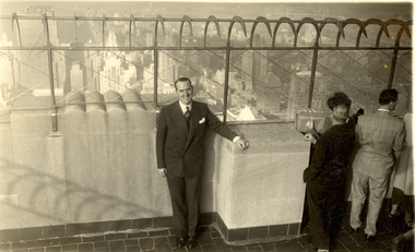 Federation University Historical Collection
Photograph, Frank Wright at the Empire State Building, Mid 20th Century
Frank Wright was a renown resident of Smeaton, where he was born on 2 August 1901. He lived at Laura Villa, and attended Smeaton State School. His father William was a gold miner and his mother's name was Sarah. Their family won many singing and instrumental awards. Frank was tutored by Percy Code and was awarded a gold medal for the highest marks in the ALCM examinations in the British Colonies at the age of seventeen years. He became the Australian Open Cornet Champion by the age of eighteen. A year later, Frank conducted the City of Ballarat Band, and later the Ballarat Soldiers’ Memorial Band. He formed the Frank Wright Frisco Band and Frank Wright and his Coliseum Orchestra. These bands won many South Street awards, and Frank as conductor won many awards in the Australian Band Championship contest. In 1933 Frank Wright sailed to England to conduct the famous St Hilda’s Band and was later appointed Musical Director of the London County Council, where he organized many amazing concerts in parks, in and around the London district. He was made Professor of Brass and Military Band Scoring and conducted at the Guildhall of Music and Drama. Frank was often invited to adjudicate Brass Band Championships around Europe, in Australia, including South Street and in New Zealand. The Frank Wright Medal at the Royal South Street competition is awarded to an individual recognized as making an outstanding contribution to brass music in Australia.Black and white photograph of a man dressed in a suit standing in the centre of the picture with several other people facing away from the camera on the right. The man is leaning against a thick art deco style armpit high wall with an extending ironwork protective fence above. The view seen beyond is of a city skyline. The man is Frank Wright and the place is the viewing platform at the top of the Empire State Building in New York.frank wright, brass bands, conductor, new york, empire state building -
Port Melbourne Historical & Preservation Society
Photograph - Bass Strait ferry, Oct 1998
Four colour photographs taken from Bass Strait Ferry .01 - outer end of Station Pier with City backdrop .02 - View to beach and London Hotel and east end of Beacon Cove .03 - Station Pier Gatehouse with Beacon Cove and two of the Beacon Cove towers .04 - View to Port Melbourne Beach, London Hotel, Beacon Cove and City skyline viewing platform/folly in foregroundpiers and wharves - station pier, built environment, london family hotel, beacon cove -
 Ballarat Tramway Museum
Postcard, Murfett Pty Ltd, Wellington Parade, East Melbourne
Colour postcard of Wellington Parade, East Melbourne with Melbourne skyline in background and Fitzroy Gardens in background. Would appear works for the underground are in progress. Has W2 509, outbound on route 29 to 'Kew Depot' and a tram (wide body car) in bound on route 74. Has on rear caption, "National View" by Murfett Pty Ltd. Australia, place for address and stamp. Taken early 70's.trams, tramways, melbourne, wellington parade, postcards, tram 484, tram 229, tram 364 -
 Melbourne Tram Museum
Postcard, Wayne Zerbe / North Australian Trading Co. for Kangaroo Gifts, Melbourne views including trams, early 1990's
Colour postcard, three panels: 1 - B class turning from Bourke into Spring St 2 - Walkway bridge (Evan Walker Bridge) over the Yarra 3 - City Skyline Back has space for name and address, stamp and a message and details of the postcard. Produced by Wayne Zerbe / North Australian Trading Co. for Kangaroo Gifts. Card No. KGL8 Has "Melbourne Australia" along the bottom edge.trams, tramways, bourke st, b class, melbourne