Showing 844 items
matching surveyors
-
 Port Melbourne Historical & Preservation Society
Map - Lagoon between Ingles and Spring Streets, Sandridge, 26 Mar 1872
Prepared by Mr ORME for the Lagoon Committee and presented with a report on 26.3.1872.Map of Lagoon between Ingles Street and Spring Street. 26 March 1872. In brown wooden frameBorough Surveyor's Stamp in bottom right hand corner.sandridge lagoon, mr orme -
Port Melbourne Historical & Preservation Society
Plan - Tramway, Normanby Road, Ingles Street to Boundary Street, Port Melbourne, 14 Mar 1893
Plan of tramway in Normanby Road from Ingles Street to Boundary Street, together with written specification for works attached (Reg 66.2), 1893.A.V. Heath (Town Surveyor) J.J. Bartlett (Mayor)engineering - roads streets lanes and footpaths, transport - tramways, town planning, town clerks, mayors, arthur victor heath, james john bartlett -
Port Melbourne Historical & Preservation Society
Document - Specification, Tramway, Normanby Road, Ingles Street to Boundary Street, Port Melbourne, 14 Mar 1893
Written specification for works attached to plan of tramway in Normanby Road from Ingles Street to Boundary Street (Reg 66.1), 1893.A.V. Heath (Town Surveyor) J.J. Bartlett (Mayor)engineering - roads streets lanes and footpaths, transport - tramways, town planning, town clerks, mayors, arthur victor heath, james john bartlett -
Port Melbourne Historical & Preservation Society
Plan - Williamstown Road, Derham Street to Raglan Street, Port Melbourne, 14 Mar 1893
Plan of Williamstown road from Derham street to Raglan street. (67.1), together with written specification of works attached. (67.2), 1893.A.V. Heath (Town Surveyor). J.J. Bartlett (Mayor).engineering - roads streets lanes and footpaths, arthur victor heath, town clerks, james john bartlett, mayors -
Port Melbourne Historical & Preservation Society
Document - Specification, Williamstown Road, Derham Street to Raglan Street, Port Melbourne, 14 Mar 1893
Written specification of works attached to plan of Williamstown Road from Derham Street to Raglan Street. (67.1) 1893.A.V. Heath (Town Surveyor). J.J. Bartlett (Mayor).engineering - roads streets lanes and footpaths, arthur victor heath, town clerks, james john bartlett, mayors -
Port Melbourne Historical & Preservation Society
Document - Specifications, Main drain, west branch, Evans Street to Esplanade East, Port Melbourne, Arthur Victor Heath, Town Clerk et al, 14 Mar 1893
Specifications for the construction of main drain west branch 1893 (together with plan attached - refer 75.2)A.V. Heath (Town Surveyor):J.J. Bartlett (Mayor)engineering - canals and drainage, arthur victor heath, town clerks, james john bartlett, mayors -
Port Melbourne Historical & Preservation Society
Document - Specification, Metalling and chanelling, Boundary Street South, Graham Street to St Vincents Street, Arthur Victor Heath, Town Clerk et al, 14 Mar 1893
Specifications (Reg. 77.1) and plan (Reg 77.2) for metalling and channelling Boundary Street South [Pickles Street] from Graham Street to St. Vincents Street. Loan works 1893, plan No. 5.A.V. Heath (Town Surveyor):J.J. Bartlett (Mayor)engineering - roads streets lanes and footpaths, town planning, town clerks, mayors, arthur victor heath, james john bartlett -
 Warrnambool and District Historical Society Inc.
Letter Book 4, 1901, 1908
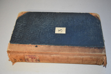
This letter book has letters, invoices, sketch maps and plans and dates from 1908 to 1910. It came from the office of John William Crawley Junior, an engineer, architect and surveyor in private practice in Warrnambool and also the official engineer of the Shire of Warrnambool from 1895 to 1935. His father, brother and son were also engineers and worked in that capacity or as the Shire Secretary for the Shire of Warrnambool, with the Crawley family members recording a total of 132 years of service to the Shire. The letter book was passed on to John Crawley’s son, Rolf, Engineer for the Shire of Warrnambool from 1935 to 1968. The letter book then came into the possession of Michael Hand who took over the private surveying business of Rolf Crawley in Warrnambool and the Warrnambool and District Historical Society has acquired the letter book, one of several Crawley ledgers, from the Michael Hand estate. This letter book is of considerable significance as it contains maps, plans, sketches and written information on the work of John William Crawley, the engineer for the Shire of Warrnambool for 40 years. This is a black-covered letter book with copies of letters and field maps and plans and an alphabetical listing at the front. Some of the letters are invoices for work carried out. The leather section of the front cover has been almost completely torn away and the binding is mended with adhesive tape. There are some torn pages. The front page has a signature and a mauve stamp. ‘Letter Book’ ‘J.Wm. Crawley (Private)’ ‘ Rolf L. Crawley, Civil Engineer, Drainage and Water Supply Engineer, Licensed Surveyor, Registered Architect, Warrnambool’ ‘4’ rolf crawley, warrnambool, john william crawley, junior, warrnambool, history of warrnambool -
 Kew Historical Society Inc
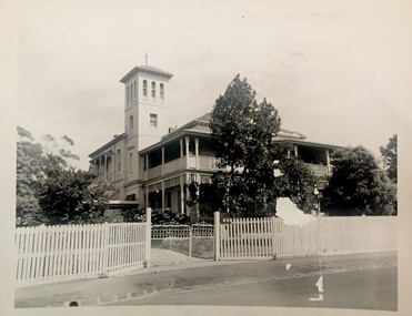
Photograph, J E & B L Rogers, 'Fernhurst', c.1959
This work forms part of the collection assembled by the historian Dorothy Rogers, that was donated to the Kew Historical Society by her son John Rogers in 2015. The manuscripts, photographs, maps, and documents were sourced by her from both family and local collections or produced as references for her print publications. Many were directly used by Rogers in writing ‘Lovely Old Homes of Kew’ (1961) and 'A History of Kew' (1973), or the numerous articles on local history that she produced for suburban newspapers. Most of the photographs in the collection include detailed annotations in her hand.The Rogers Collection provides a comprehensive insight into the working habits of a historian in the 1960s and 1970s. Together it forms the largest privately-donated collection within the archives of the Kew Historical Society.Small, black and white photo of Fernhurst in Kew, built for the architect and surveyor George Wharton. (Now demolished)"Probably built in 1860s / Fernhurst"fernhurst -- kew (vic), historical houses -- kew (vic), kew mansions -
Port Melbourne Historical & Preservation Society
Plan - Photographic copy, Plan of allotments marked at Sandridge, 1849, Lindsay Clarke, Surveyor, c. 1849
Photographic copy of 'Plan of allotments marked at Sandridge in the Parish of South Melbourne; by surveyor Lindsay Clarke 1849On back, '7' in inktown planning, business and traders - hotels, lindsay clarke, wilbraham frederick evelyn liardet, wfe liardet -
Ringwood and District Historical Society
Envelope, Packet: Paper on Clement Hodgkinson, Nunawading Surveyor
Paper delivered to Nunawading Historical Society August 1967 on Clement Hodgkinson, Surveyor of Nunawading; Letter to Ellie Pullin -
 Stratford and District Historical Society
Theodolite
... SURVEYORS ...This theodolite was used by `Mr Dawson' (presumably William Tennant Dawson c.1820-1873) who `surveyed much of the area around and beyond Stratford'. It was damaged by the fire which burnt the original Roseneath home in 1921, when the Macleods were in residence. (Mrs W.T. Dawson was a Macleod). One little boy aged 3 years was given the job of saving everything on the kitchen table when the fire started at breakfast time. The theodolite was possibly in use by Dawson when he laid out St Kilda Road.This theodoite consists of a bottom plate, which is damaged and has melted metal. This rises to a ball joint, on which is pivoted another plate on which were housed four screws, of which three remain, to adjust the level. Above this is another plate, with compass markings and melted glass."Troughton and Simm's/London" in fine engraving on upper plate.surveyors, instruments -
Port Melbourne Historical & Preservation Society
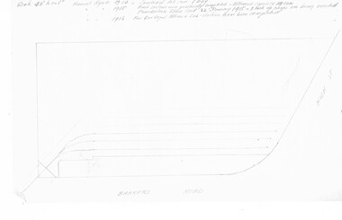
Plan - Proposed improvements, Foreshore, east of Lagoon Dock, Port Melbourne, Engineering Department, City of Port Melbourne, 25 Mar 1919
1919 plan - proposed foreshore improvement east of the Lagoon Dock.A.V. Heath (Town Surveyor):R. H. Gill (Mayor)built environment - recreational facilities, arthur victor heath, town clerks, richard henry gill, mayors -
Port Melbourne Historical & Preservation Society
Plan - Possible maritime shed, Borough of Sandridge, 1870s
An identified building plan - presumably a maritime shed (front elevation faces "the river") - proving front, traverse and longitudinal sections. Possibly two buildings. Plan No. 3.Charles Clay B.S. [Borough Surveyor]:W. Weatherston[e]built environment - civic, piers and wharves, charles clay, william weatherston[e] -
Port Melbourne Historical & Preservation Society
Plan - Heath Street, Port Melbourne, Borough of Sandridge, Mar 1864
Plan of longitudinal and cross sections of proposed works in Heath Street.M. Tierney:Denis Sullivan:Thos. P. Warren:Geo. Kelly (Borough Surveyor)engineering - roads streets lanes and footpaths, m tierney, denis sullivan, thomas p warren, george kelly -
 Ringwood and District Historical Society
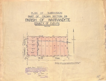
Map - Plan of Subdivision, Part of Crown Section 24, Parish of Warrandyte, County of Evelyn - 1951
Survey map of residential allotments in Berringa Road and Milne Road, Park Orchards, Victoria. Russell Francis Kinnane, Licensed Surveyor, 4th October, 1951. -
 Falls Creek Historical Society
Plan - Leases of part of Falls Creek Tourist Area
Bob (Herman) Hymans (a former member of the Royal Netherlands Navy was born in Bloemendaal, Holland on 30th September 1922. During World War II he fought against the Japanese in the Dutch East Indies (now Indonesia) and was imprisoned in Changi and on the Burma Railway. After gaining qualifications as a Ski Instructor, Bob arrived in Falls Creek in May 1950. Working as an Instructor and Supervisor at Bogong Lodge, Bob decided his future was in accommodation. He was successful in negotiating an indenture for land from the State Electricity Commission (SEC). It took Bob two years to build his Grande Coeur Chalet but, tragically, it was burned down in August 1961. Bob also built the first Chairlift in Australia. This was a single chairlift and the structure was built from wooden electricity poles. He was constantly full of new ideas and proposals for the village. Bob Hymans died on 7th May 2007. This Collection of documents and letters tells the story of Bob’s endeavours to develop Falls Creek into the ski village it is today. This map is significant because it documents boundaries of early leases in Falls Creek Tourist Area.This map is part of Bob Hymans documents. It is a large Surveyor's Plan of a section of the Falls Creek Tourist Area. It is endorsed by J Parker, Chief Surveyor of the State Electricity Commission of Victoria on 27-3-84. It shows streets, lot numbers and measurements. It was a compilation created from existing lease maps. Heading - PART OF FALLS CREEK TOURIST AREA PART OF CROWN ALLOTMENT 1 PARISH OF CARRUNO PART OF CROWN ALLOTMENT 1 PARISH OF DARBALANG COUNTY OF BOGONGmap of falls creek, falls creek leases, falls creek 1980s -
Stawell Historical Society Inc
Map, Underground Mine Workings Stawell, 1894
Plan and Elevations of mine workings 12 September 1894. J H Bate Mining Surveyor. Framed under Glassstawell, mining, plans -
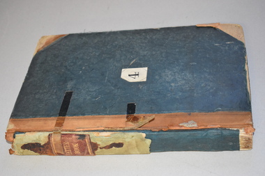
 Warrnambool and District Historical Society Inc.
Letter Book 3, 1901 - 1908, 1900
This letter book has letters, plans and maps and dates from 1901 to 1908. It came from the office of John William Crawley, Junior, an engineer, architect and surveyor in private practice in Warrnambool and also the engineer for the Shire of Warrnambool from 1895 to 1935. His father, brother and son were also engineers and worked in that capacity or as the Shire Secretary for the Shire of Warrnambool, with the Crawley family recording a total of 132 years of service to the Shire. The letter book was passed on to John Crawley’s son, Rolf, engineer for the Shire of Warrnambool from 1935 to 1968. The letter book then came into the possession of Michael Hand who took over the private surveying business of Rolf Crawley in Warrnambool. The Warrnambool and District Historical Society has acquired the letter book, one of several Crawley ledgers, from the Michael Hand estate. The Shire of Warrnambool existed from 1863 to 1994. This letter book is of considerable significance as it contains maps, plans and letters produced by John William Crawley Junior, the engineer for the Shire of Warrnambool for 40 years. It will be very useful for research. This is a hard cover letter book of 717 pages. It has a black cover with brown leather binding on the cover edges and spine. The leather is worn away in places. The letter book contains an alphabetical index, handwritten letters, sketch plans and maps. There is a mauve stamp on the inside front cover. ‘3’ ‘Letter Book 1901 to 1908’ ‘Letter Book J.Wm. Crawley’ ‘Rolf L. Crawley, Civil Engineer, Drainage and Water Supply Engineer, Licensed Surveyor, Registered Architect, Warrnambool’ john william crawley junior, warrnambool, rolf crawley, warrnambool, history of warrnambool -
 Melbourne Tram Museum
Document - Research Notes, H. S. McComb, notes on the PMTT depots, 1950's
Set of papers - 20 hand prepared foolscap sheets, giving notes on the PMTT depots, extracts from Surveyor field books, notes on doubtful matters, sketches of curves, surveyor notes, relevant dates of surveys, Items 2041 to 2052 within box 72.3 in a brown folder marked "PMTT" in red pencil.trams, tramways, pmtt, malvern, routes, track, malvern depot, kew depot, surveys -
 Bendigo Historical Society Inc.
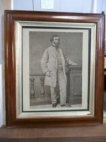
Photograph - RICHARD W LARRITT
Framed photograph of Richard William Larritt, Bendigo/Sandhurst first surveyor. Under glass in brown wooden frame with gold trim.photograph, portrait, richard william larritt -
Port Melbourne Historical & Preservation Society
Plan - Water cart used in road construction, Borough of Sandridge, 21 Nov 1870
From a group of maps and plans not required by the Port Melbourne Council Engineering Department in May 1994 and offered at that time to the Port Melbourne Historical Society.Plan of water cart used in road construction including 4 diagrams and scales: signed by Borough Surveyor, Nov 21 1870.built environment - civic, engineering, engineering department - borough of sandridge -
Whitehorse Historical Society Inc.
Document, Marie Jackschowsky claim, 1962?
Surveyor's and other notes detailing claim of Marie (Mary) Jackschowsky to land originally owned by Johann August Schwerkolt.Surveyor's and other notes detailing claim of Marie (Mary) Jackschowsky to land originally owned by Johann August Schwerkolt. Application no. 53033.Surveyor's and other notes detailing claim of Marie (Mary) Jackschowsky to land originally owned by Johann August Schwerkolt. schwerkolt, johann august, jackschowsky, mary elizabeth, schwerkolt cottage, separation street, northcote -
 Ringwood and District Historical Society
Map, Proposed Subdivision - Hilltop Estate, Heathmont, Victoria - circa 1925
Plan of Part of Crown Allotments 16 & 18, Parish of Ringwood, County of Mornington. Subdivision includes Site for Heathmont Station, Heathmont Road, George Street, Lilian Street, Edith Street, Edna Street, Great Ryrie Street. Inset locality plan also shows nearby Electric Railway Estate and Heathmont Station Estate. L.H. Webber, Licensed Surveyor, 440 Little Collins Street, Melbourne. -
Port Melbourne Historical & Preservation Society
Plan - Cutting and filling, Ingles Street from Station Place to Crockford Street, 1860 - 1874
Plan for cutting and filling re Ingles St, and cross streets Station Place to Crockford St."Borough Surveyor's Office Sandridge" upper right hand corner on face.engineering - roads streets lanes and footpaths -
Port Melbourne Historical & Preservation Society
Plan - Bridge over lagoon, Graham Street, Sandridge, Borough of Sandridge, 15 Oct 1878
Drawing of Graham Street bridge over the lagoon, 1878.Signed by E. Clark, Town Clerk, and Chas. Clay, Borough Surveyor.engineering - bridges, edward clark, town clerks, charles clay, graham street, sandridge lagoon -
Port Melbourne Historical & Preservation Society
Plan - Council Chambers, Borough of Sandridge, Borough of Sandridge, Mar 1861
1861 Plan for the Borough Council Chambers, Sandridge, showing "elevation" and "plan"."Frederick William Bull, Municipal Surveyor" (Sandridge March 28th, 1861)local government - borough of sandridge, built environment - civic, frederick william bull -
Port Melbourne Historical & Preservation Society
Plan - Proposed crossing, Rouse Street at Nott Street, George Kelly, Borough Surveyor, 27 Oct 1864
Place of Proposed Crossing in Rouse Street (Corner Nott Street) PlanGeo. Kelly, Cr.(?), Borough Surveyor, Sandridge, 27-10-1864engineering - roads streets lanes and footpaths, george kelly -
 Wangaratta High School
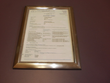
WHS Framed Certificate, 2010
White Administration building occupancy permit, in a gold frameGRAEME BUCHAN & ASSOCIATES PTY. LTD. Building Surveyors OCCUPANCY PERMIT -
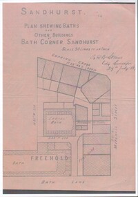 Bendigo Historical Society Inc.
Document - Plan of Buildings and Baths at Bath corner, 19/09/2023
Photographic copy of Shop layout at Bath corner Sandhurst (Charing Cross, Mitchell Street & Bath Lane); including Men's and Women's public baths dated 29 July 18??Includes singed GRB Steane, City Surveyor 29th July 18??city baths, bath corner, charing cross