Showing 427 items
matching topography
-
 Lakes Entrance Historical Society
Photograph, 14/04/2013 12:00:00 AM
Colour aerial photograph of Entrance at New Works showing the sand transfer building Lakes Entrance VictoriaNew Worksaerial photograph, waterways, topography -
 Lakes Entrance Historical Society
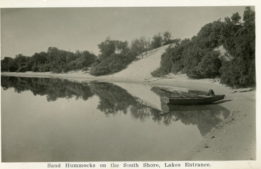
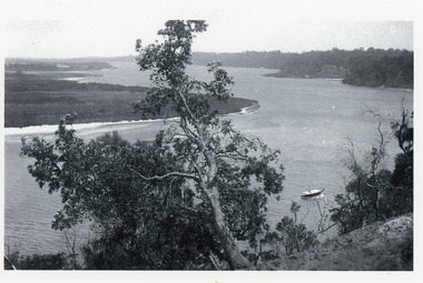
Postcard, Bulmer H D, 1930c
A second copy exists 16 x 25Black and white postcard of the south shore of Cunninghame Arm. It shows a rowing boat with dog, on the shore and the scrub covered sand hummocks. Lakes Entrance VictoriaSand Hummocks on South shore, Lakes Entrance.bridges, topography, waterways -
 Lakes Entrance Historical Society
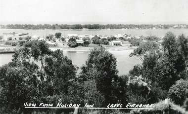
Postcard - Township, The Lakes Studio, 1945
2 Black and White postcard size copies|1 Colour tinted copy postcard size|1 Black and White enlargement 16 x 25 cmBlack and white postcard of the town, taken from Holiday Inn Guest house, situated on the Kalimna Heights escarpment. It shows light trees and scrub in the foreground, the township situated between the North Arm and Cunningham arm, the hummocks of the southern shore. The hulk of the Baang Yarnda is lying on the south shore of North Arm. Lakes Entrance VictoriaView from Holiday Inn Lakes Entrancewaterfront, topography, township -
Lakes Entrance Historical Society
Book, Mc Intyre Alan J M Lawton G, Longmans Australia Geographies Gippsland No 10, 1958
Basic information about Gippsland geography agriculture and industries written for school students.agriculture, industrial, topography -
Lakes Entrance Historical Society
Book, Trower Rosalie and Chapman Steve, Wilsons Promontory National Park
Photographic reproductions, historical detail and tourism concepts of Wilsons Promontory Victoria.parks, topography, tourism -
Lakes Entrance Historical Society
Book, Buchan Primary School, Buchan 1905 School Centenary 1877-1977, 1977
Booklet produced for the Buchan Primary School Centenary in 1977, includes lists of pupils and parents from 1914-1976 includes information on Buchan East, Buchan South, Murrindal, Gelantipy, Jackson Crossing, Butchers Ridge, W Tree, Boggy Creek, Tara Valeschools, settlers, topography -
 Lakes Entrance Historical Society
Photograph - Lakes Tyers Landing, 1999 c
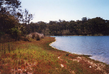
Site was important during tourism era of the 1880's to 1940's, when coachloads of passengers transferred to trips around Lake Tyers and up to Nowa Nowa. Also known as Bulmer's Landing.A colour photograph of the former tourist landing on Lake Tyers, showing remnant piles of a jetty, calm waters of lake and a high tree covered bank opposed the low jetty shore. Lake Tyers Beachtopography, waterways, landing -
Lakes Entrance Historical Society
Book, Land Conservation Council Victoria, Final Recommendations Gippsland Lakes hinterland Area, 1983
1980 report and recommendations of the Victorian Land Conservation Council, for the balanced use of public land in teh gippsland Lakes Hinterland includes reserves schools forests rivers foreshores and other public sites. Map and diagrams added.topography, parks, waterways -
Lakes Entrance Historical Society
Book, Bird E C F, The Silt Jetties at the Mitchell River, 1972
The first of a series of scientific and historical studies of Gippsland to be published by the Bairnsdale Advertiser. The formation of the Mitchell River Silt Jetties is explained, and schemes for protecting this unique and fragile area of Victoria are suRuth Clarkgenealogy, waterways, topography -
Lakes Entrance Historical Society
Book, Nankin Henry, Victorias Alps and Australian Endangered Heritage, 1983
A description of the terrain flora fauna management and recommended management of Victorias Alpine region, produced by the Australian Conservation Foundation. Indexedtopography, natural history, vegetation -
 Lakes Entrance Historical Society
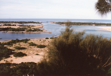
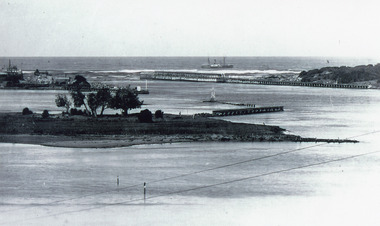
Photograph - The Entrance, 1995c
Second colour copy as 01601-1 portrait size 15 x 10Colour photograph of the entrance from Bass Strait to the Gippsland Lakes. It shows buildings on Bullock Island including Peck's factory. Western end of Bullock Island and area below Jemmys Point, both made during dredging operations over many years. Two fishing boats in entrance. Lakes Entrance Victoria room display, waterways, topography -
 Lakes Entrance Historical Society
Photograph - Reeves Channel, 1915c
Original in possession of descendant of Arthur Seagrove, teacher at Johnsonville School 1920c.Black and white photograph of Reeves Channel, Gippsland Lakes, showing a launch in the Narrows below Jemmys Point, Rigby Island and a distant view of Fraser Island and Flannagan Island opposite the steep cliffs of the mainland shore. Lakes Entrance Victoria'To Rit with love from Arthur' on backislands, waterways, topography -
 Lakes Entrance Historical Society
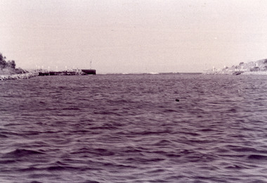
Photograph - The Entrance, Fish, Marie, 1995c
Black and white photograph showing view of entrance with eastern and western concrete and rock piers. Photo taken from boat in the channel. Waves breaking on bar at the entrance, at Lakes Entrance, Victoriaon back - The Entrance - taken from works boat, 1995 topography, waterways, piers -
 Lakes Entrance Historical Society
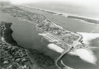
Photograph - Lakes Entrance, 1975c
Black and white photograph of an aerial view of township and Kalimna Heights, showing the North Arm bridge and boat ramp, sand buildup in the lake system, boat harbour, sand hummocks and beach as far as Red Bluff. Lakes Entrance Victoriaaerial photograph, topography, township -
 Lakes Entrance Historical Society
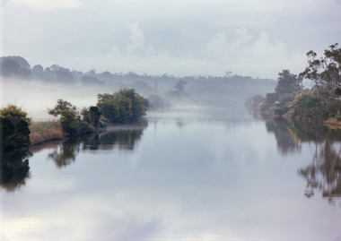
Photograph, 1994
Also second identical copyColour photograph of the Tambo River, showing mist over the river and banks either side. Swan Reach Victoria vegetation, topography, waterways -
 Lakes Entrance Historical Society
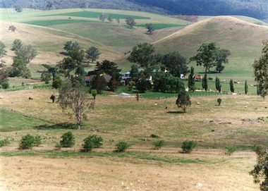
Photograph - Buchan Station, Tambo Shire, 1994 c
Also second identical copyColour photograph of Buchan Station, shows farming buildings situated among trees, both cultivated and uncultivated paddocks around property, forested hills in background. Buchan Victoriaagriculture, animals, topography -
 Lakes Entrance Historical Society
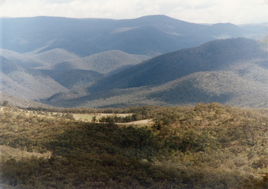
Photograph - Suggan Buggan, Tambo Shire, 1994 c
Also second identical copyColour photograph of the scenery in Suggan Buggan, showing very heavily forested mountainous country, a small area of cleared land centre left foreground. Suggan Buggan Victoriasettlement, agriculture, topography -
 Lakes Entrance Historical Society
Photograph - Bullock Island, 1915c
On back of original 'To Rit with love from Arthur' (Arthur Seagrove - Head Teacher, Johnsonville Primary School - 1920)Black and white photograph of Bullock Island and the man-made entrance from Bass Strait. It shows the Western end of Bullock Island, some natural vegetation, jetty and timber groynes, trading vessel standing outside entrance. Lakes Entrance Victoriawaterways, islands, topography -
 Lakes Entrance Historical Society
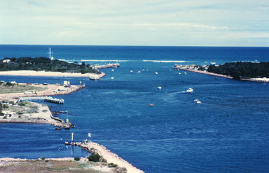
Photograph - The Entrance, Fraser Ian, 1995c
Colour photograph of the entrance from Bass Strait to the Gippsland Lakes. It shows the western end of Bullock Island and the entrance to North Arm, cars parked on island and many people fishing. This area built up during dredging operations over many years. Lakes Entrance Victoria topography, fishing industry, boats and boating -
 Lakes Entrance Historical Society
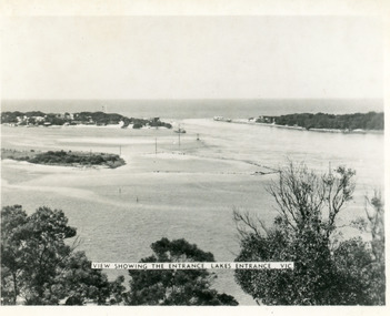
Photograph - The Entrance, Martin Orville, 1940c
Another copy Black and white 7 x 8.5 with inscription'View showing the Entrance, Lakes Entrance, Vic'Black and white photograph of Bullock Island, the New Works, township and entrance from Bass Strait to the Gippsland Lakes. Taken at high tide. Lakes Entrance Victoriaislands, waterways, topography -
 Lakes Entrance Historical Society
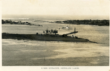
Postcard - Bullock Island, Bulmer H D, 1923c
Also same image|Faded copy 10x15|Black and White 12x17.5|Black and White 20x28.5Black and white postcard of the entrance to the Gippsland Lakes, showing buildings at New Works, cranes on ends of piers, jetty and bathing boxes on bullock Island, steamer passing island. Lakes Entrance VictoriaLakes Entrance, Gippsland Lakeswaterways, islands, topography -
 Lakes Entrance Historical Society
Photograph - The Entrance, 1922c
Black and white copy 9.5 x 15|Black and white copy 12x18Black and white photograph of the entrance and Bullock Island. It shows the western end of Bullock Island with bathing boxes, rock groynes, and sandy shore beneath Jemmys Point. Lakes Entrance VictoriaLakes Entrance, Gippsland Lakesislands, waterways, topography -
 Lakes Entrance Historical Society
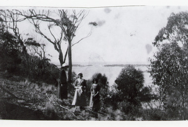
Photograph, 1920c
Black and white photograph showing three women at viewing site Kalimna of the Entrance to Bass Strait from the Gippsland Lakeswaterways, topography, people -
 Lakes Entrance Historical Society
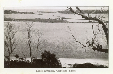
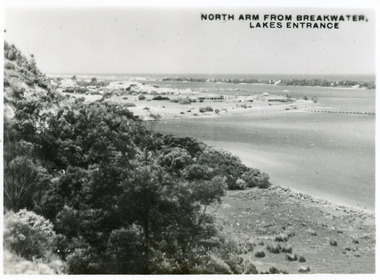
Postcard - North Arm Lakes Entrance, 1945c
One other copy same sizeBlack and white small format postcard of the entry to the North Arm, taken from Jemmys Point. It shows a steep cliffside above the calm waters, township of Lakes Entrance and Cunninghame Arm, and sand hummocks of southern shore in distance. Lakes Entrance VictoriaNorth Arm from Breakwater - Lakes Entrancetownship, waterways, topography -
 Lakes Entrance Historical Society
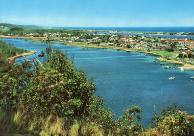
Postcard - Lakes Entrance, Engelander John & Co Pty Ltd, 1980c
Panoramic view of Lakes Entrance taken by Melbourne firm for West Germany A.F.K. International Publishers of world's most famous beauty spotsColour postcard with serrated edge, of the township, situated between Cunninghame Arm and North Arm. Boats moored at jetties and beside boat ramps in North Arm. Photo taken from Kalimna Heights. Dredged sand dumped in North Arm bight. Lakes Entrance VictoriaLakes Entrance, Victoria, Australia (on back) waterways, topography, township -
 Lakes Entrance Historical Society
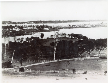
Photograph - Lakes Entrance, 1935c
Enlarged from postcard produced for Mrs Allen to advertise Allen's Tearoom at the brow of Myer St hill, known as Allen's Hill to locals.|This is the paired before photograph showing the left hand side on Butchers paddock in the panoramic views, the right hand side number 01715. This photograph used in the 150 year Lakes Entrance 1858-2008 display.Black and white photograph of the township, taken from Allen's Hill, Myer St. It shows the town between Cunninghame Arm and North Arm, cleared and fenced paddocks in foreground, New Works village and sand hummocks in distance. Lakes Entrance Victoria township, waterways, topography -
 Lakes Entrance Historical Society
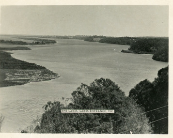
Postcard - Reeves Channel, Valentine Series, 1930c
Other copy similar view with inscription 'The Lakes, Lakes Entrance Vic'Black and white postcard of Reeves Channel Gippsland Lakes, showing Rigby, Fraser and Flannagan Islands opposite the steep shoreline of the mainland. Natural vegetation of Jemmys Point in foreground from which photograph was taken. Lakes Entrance VictoriaKalimna from Jemmys Point Lakes Entranceislands, waterways, topography -
 Lakes Entrance Historical Society
Postcard - Reeves Channel, Valentine Series, 1930c
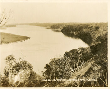
Black and white small format postcard of Reeves Channel Gippsland Lakes, taken from Jemmys Point. It shows a glimpse of the Princes Highway, the steep shoreline of the mainland opposite Rigby Island with Fraser Island and Flannagan Island in distance. Lakes Entrance VictoriaKalimna Cove Lakes Entranceislands, waterways, topography -
 Lakes Entrance Historical Society
Postcard - Reeves Channel, 1930c
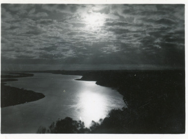
3 identical 6 x 8.5|1 same size hand tinted 6 x 8.5Black and white small format postcard of a sunset scene on Reeves Channel, Gippsland Lakes. It shows sunlight reflected through clouds and on the lake between Rigby Island and the mainland. Lakes Entrance Victoriaislands, waterways, topography -
 Lakes Entrance Historical Society
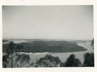
Photograph - Rigby Island, 1930c
Second copy similar viewBlack and white photograph of Rigby Island, Gippsland Lakes Victoria. It shows Reeves Channel on right of photo, Hopetoun Channel on left, The Narrows below Jemmys Point from which photo was taken. Lakes Entrance Victoriaislands, waterways, topography