Showing 1650 items matching " tourism"
-
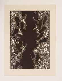 Ararat Gallery TAMA
Print, Nanette Bourke, The Growth of Tourism, 1988
Settling in Moyston in 1984, Nanette Bourke is a prominent figure in the Ararat and Grampians arts community, perhaps best known as a member of the ‘Grampians Four’ group of artists. Bourke has been a printmaker since the late 1960s, having studied at the Julian Ashton Art School in Sydney, and at art societies and the CAE in Melbourne before relocating to Western Victoria. Inspired by the woodcuts and linocuts by Melbourne artists of the 1920s and 1930s - Napier Waller, Murray Griffin, and especially Eric Thake - Bourke embraces the sophisticated results that can be achieved in this medium. Bourke holds a deep affinity with the natural environment, which is integral in her artistic life. Many of the works in this exhibition are inspired by the natural environment of the Grampians. In contrast to the often joyous depictions of Australian native flora, Bourke’s imagery also presents a poignant reminder of humankind’s negative impact on the environment. -
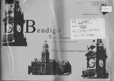 Bendigo Historical Society Inc.
Document - Michele Mathews collection - Bendigo Tourist Interpretive Centre, Old Post Office Building Pall Mall, Design Development Report - Draft unbound copy with comments and corrections, Bendigo Post Office Tourism Interpretive Centre
Compilation of background information for the Post Office Interpretive CentreMichele Mathews collection - Bendigo Tourist Interpretive Centre, Old Post Office Building Pall Mall, Design Development Report Draft copy with corrections and comments throughout Unbound copyDraft copy with comments and corrections throughoutbendigo post office interpretive centre -
 Glenelg Shire Council Cultural Collection
Photograph - Photograph - Marine Discovery Centre Portland, Victoria, Oct-00
Coloured photograph: Rhian Maddox, the Tourism Officer at Nelson, standing in front of a display board in the Nelson Visitor Information centre. See 10394Back: yellow sticker -'Rhian Maddox Tourism Officer, Nelson' -
 Warrnambool and District Historical Society Inc.
Booklet - Warrnambool Visitor's Handbooks 1979-2024, Collett, Bain and Gaspar, Printers, 1979-2014
This is a collection of eight Warrnambool Visitor handbooks produced between 1979 and 2014 by the City of Warrnambool Tourist Information Centre. They contain maps of Warrnambool, lists of services, accommodation and tourist attractions as well as many advertisements for local businesses.These handbooks give a useful snapshot of businesses and tourist attractions in Warrnambool for each of the years covered. (1979, 1980, 1986, 1990, 1993, 1994, 1995, 2014)[.1a] A 48 page booklet with white pages and blue printing. The front cover has a coloured photograph of Flagstaff Hill with boats on a man made lake in the foreground looking across Lake Pertobe toward South Warrnambool. [.1b] A coloured bifold brochure. The front cover has a fisherman on a cray-boat holding a crayfish in the lower section. The top quarter has a blue back ground with white printing. The rear cover is red and has small photos of the Hopkins River and the Framlingham Forest. [.2] A 48 page booklet with white pages and black printing. The front cover is white with black writing on the left hand side and a colour photograph of the Loch Ard peacock. The Warrnambool Premier Town stylised logo of seven Norfollk pines above blue waves is in the top right hand corner. There is a blank ink Warrnambool Library stamp underneath the logo. The rear cover has photographs of The Twelve Apostles and the Hopkins Falls and the Premier Town Logo [.3] A 40 page booklet with mainly black printing on white paper. There are three fold out maps of Warrnambool and the surrounding district. The glossy cover has a black background with a colour photograph of the Twelve Apostles taken at sunset. The rear cover has three small of Proudfoot's boathouse on the Hopkins River, Flagstaff Hill, and the main beach area. The front cover has black writing inside to peach coloured rectangles. The inside rear cover has a fold out coloured tour map of Western Victoria. [.4] A 40 page booklet printed on glossy white paper with coloured photographs and black and red printing. The front cover has a photograph of The Twelve Apostles surrounded by a white border. There is red writing in the upper border. There is a sandy coloured writing superimposed across the bottom of the photograph and a Victoria's Shipwreck Coast logo in the bottom right hand corner. [.5] A 44 page booklet printed on white paper with black printing. The cream coloured cover has a pale red rectangle with blue writing on the right hand facing edge and includes two stylised Norfolk pines and with waves underneath. There is is an intersecting blue rectangle with cream printing. [.6] A 48 page booklet printed on white paper with black printing. The cover is brown with a cream vertical strip containing black writing on the right hand side. There is a stylised map from Geelong to Mount Gambier showing the Great Ocean Road across the cover. [.7] A 48 page booklet printed on white paper with black print. The glossy colour cover has a photograph of a Southern Right whale fluke. There is white printing on a the blue background of the sky and sea. The bottom left hand side of the front cover has a Tourism Victoria logo made of jigsaw puzzle pieces. The back cover has a stylised coloured map of The Great Ocean Road located in a white rectangle at the top of the page. Within the rectangle is a small map of Australia locating Victoria and the part of Victoria covered by the map. [.8] A 64 page A5 coloured booklet printed on white pages with black print. The white front cover has black and grey print with a colour photograph of two people holding coffee cups watching four race horses being exercised on the beach and in the water of Lady Bay in the early morning. The bottom right hand corner has a Tourism Victoria logo. The rear cover has a mainly blue back ground with a pink orange and green colour splats contains words advertising the 2015 Fun 4 Kids Festival [.1a] Warrnambool The Heart of Victoria's Great Southwest Visitor's Handbook [.1b] Warrnambool City for all seasons; The Heart of Victoria's Great Southwest [.2] Warrnambool visitor's handbook Warrnambool Premier Town 1979-1982 [.3] Warrnambool Handbook Victoria [.4] Warrnambool The Shipwreck Coast [.5] Welcome to Warrnambool Warrnambool Visitors Handbook 1993-1994 [.6] Welcome to Warrnambool Visitors Handbook 1994-95 Rear cover: Warrnambool Centre of Victoria's Shipwreck Coast on Australia's Great Ocean Road [.7] Warrnambool Shipwreck Coast - Great Ocean Road; You'll love every piece of Victoria; Visitors Handbook [.8] Warrnambool Great Ocean Road Official Visitor Guide; It's a wonderful Warrnambool; You'll love every piece of Victoria visitvictoria.com. Rear Cover Live entertainment.Workshops.Creativity.Action 28 June - 5 July 2015 Australia's Best Children's Festival F4K The ultimate winter school holiday adventure Fun 4 kids festival Warrnambool For more information visit Fun4kids.com.au Warrnambool great Ocean Road Victoriawarrnambool, visitor handbooks, tourist information guides, warrnambool maps -
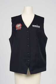 City of Greater Bendigo - Civic Collection
Uniform - Vest
Part of a uniform worn by staff and volunteers at the Visitor Centre at the Old Bendigo Post Office for the duration of the exhibition Making a Nation which closed in 2011.Navy blue vest with embroidered Making a National patch on upper right and Bendigo Tourism on upper left front. Five buttons on front.r; Making A Nation / Federation Exhibition / 1901 / Sir John Quick / BENDIGO l; Bendigo Tourismbendigo tourism, bendigo post office -
Glenelg Shire Council Cultural Collection
Administrative record - Videotape - Discovery Coast and Hinterland Tourism, Portland Video Productions, 'Discovery Coast and Hinterland', n.d
Glenelg Shire CouncilFront: 'DISCOVERY COAST & HINTERLAND TOURISM DURATION 14 MTS' -
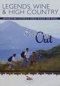 Falls Creek Historical Society
Booklet - Legends, Wine & High Country - Stepping Out
This is one of several booklets published to promote tourism throughout Victoria. It contains detailed information to promote tourism in the region of Northeast Victoria. It was published by the Victorian Tourism Information Service in April 1999.This item is important as it documents how the region of Northeast Victoria has been promoted by the Victorian government. An A4 sized marketing booklet, including images, maps and detailed information about walks, trails and activities in .Northeast Victoria published by the Victorian Tourism Information Board'tourism victoria, falls creek tourism, legends wine and high country, victorian tourism information service -
Port Melbourne Historical & Preservation Society
Pamphlet - Eighteen ways to enjoy Port Melbourne, Pat Grainger, 1994
Produced by Pat Grainger for the Port Melbourne Tourism Committee to hand out at Station Pier to cruise passengers.Eighteen ways to enjoy Port Melbourne' a pamphlet produced by the Port Melbourne Tourist Association November 1994 (refer 1468)tourism, port melbourne tourism association, pat grainger -
Marysville & District Historical Society
Flyer (item) - Brochure, Artworkz Tourism, Marysville-Steavenson Falls, 2018
A brochure including photographs and a tourist map of Marysville and some of the area's attractions focusing on Steavenson Falls. A brochure including photographs and a tourist map of Marysville and some of the area's attractions focusing on Steavenson Falls. The Steavenson Falls is named after the Victorian Assistant Commissioner of Roads and Bridges, John Steavenson who arrived in Victoria in the early 1860s.Shadowed by over 30 Mountains and/ on the banks of the beautiful Goulburn River/ and Lake Eildon. This is our playground.marysville, steavenson falls, victoria, waterfalls, john steavenson -
Marysville & District Historical Society
Document (item) - Historic Factsheet, Artworkz Tourism, Steavenson Falls Marysville, Unknown
An historic factsheet regarding Steavenson Falls in Marysville in Victoria.An historic factsheet regarding Steavenson Falls in Marysville in Victoria.steavenson falls, marysville, victoria, waterfalls -
Marysville & District Historical Society
Flyer (item) - Information Flyer, Artworkz Tourism, Marysville-Historic Timber Tramway Trestle Bridge, Post 2009
A flyer that was produced as a guide to the historic timber tramway trestle bridge near Marysville in Victoria.A flyer that was produced as a guide to the historic timber tramway trestle bridge near Marysville in Victoria. The historic timber tramway trestle bridge is along the Michaeldene Walking Track near Marysville in Victoria. The Michaeldene Trail to Taggerty River Lookout is a 4.3 kilometer lightly trafficked loop trail located near Marysville, Victoria. The track is one of several walking tracks located in and around Marysville in Victoria.timber tramway trestle bridge, marysville, victoria, michaeldene walking track, taggerty river, taggerty river lookout -
Marysville & District Historical Society
Flyer (item) - Information Flyer, Artworkz Tourism, Marysville-Phantom Falls, Post 2009
A flyer that was produced as a guide to Phantom Falls near Marysville in Victoria.A flyer that was produced as a guide to Phantom Falls near Marysville in Victoria. Phantom Falls is located off Lady Talbot Drive. Lady Talbot Drive a 24 kilometer scenic rainforest car journey which passes a number of walks and waterfalls in the Yarra Ranges National Park. Lady Talbot Drive is named after Lady Sarah Elizabeth, the wife of Sir Reginald Talbot, who was the Governor of Victoria from 25th April, 1904 to 6th July 1908.phantom falls, marysville, victoria, lady talbot drive, lady talbot forest drive, sir reginald talbot, lady sarah elizabeth talbot, yarra ranges national park -
Marysville & District Historical Society
Flyer (item) - Information Flyer, Artworkz Tourism, Marysville-Keppel Falls, Post 2009
A flyer that was produced as a guide to Keppel Falls near Marysville in Victoria.A flyer that was produced as a guide to Keppel Falls near Marysville in Victoria. The Keppel Falls are named after the Keppel Family who were among Marysville's earliest pioneering families.keppel falls, marysville, victoria, waterfalls, keppel family -
Marysville & District Historical Society
Booklet (item) - Information Booklet, Artworkz Tourism, Marysville-Keppel Falls, 11-03-2017
An information booklet that was produced as a guide to Keppel Falls near Marysville in Victoria.An information booklet that was produced as a guide to Keppel Falls near Marysville in Victoria. The Keppel Falls are named after the Keppel Family who were among Marysville's earliest pioneering families.keppel falls, marysville, victoria, photograph, waterfalls, keppel family -
Marysville & District Historical Society
Flyer (item) - Information Flyer, Artworkz Tourism, Marysville-Meeting of the Waters (Marysville), Post 2009
A flyer that was produced as a guide to the Meeting of the Waters near Marysville in Victoria.A flyer that was produced as a guide to the Meeting of the Waters near Marysville in Victoria. The meeting of the Waters is where the two rivers, the Taggerty River and Whitehouse Creek combine. meeting of the waters, marysville, victoria, taggerty river, whitehouse creek -
Marysville & District Historical Society
Ephemera (Item) - Information flyer, Artworkz Tourism, Buxton Trout & Salmon Farm, Unknown
A digital copy of an information flyer that was produced as a guide to Buxton Trout & Salmon Farm in Victoria.A digital copy of an information flyer that was produced as a guide to Buxton Trout & Salmon Farm in Victoria. Buxton Trout and Salmon Farm was established in 1958 and is Australia's first commercial trout farm where trout have been reared for over 50 years.buxton, victoria, buxton trout and salmon farm, advertising brochure, brochure, trout, salmon -
Marysville & District Historical Society
Flyer (Item) - Information flyer, Artworkz Tourism, Bruno's Art and Sculpture Garden, Unknown
A flyer that was produced as a guide to Bruno's Art and Sculpture Garden in Marysville in Victoria.A flyer that was produced as a guide to Bruno's Art and Sculpture Garden in Marysville in Victoria.bruno torfs, gardens-design, marysville, victoria, sculpture, australia, sculpture garden, sculptors, bruno's art and sculptures garden, 2009 black saturday bushfires, information flyer, artworkz tourism -
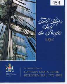 Greensborough Historical Society
Book, Tourism Canada, Tall Ships Sail the Pacific, 1778-1978
Records the discovery of Canada by James Cook in 1778. Also later efforts of explorers in opening up the interior of the country.This book was issued for the bicentenary of the discovery of Canada by Captain James Cook RN.A full colour 35 page book on British Columbia, Canada and the history of its discovery.Nilcaptain james cook, canada, british colombia, simon fraser, alexander mckenzie, captain george vancouver, sailing ships -
Ringwood and District Historical Society
Booklet, Maroondah City Council - Tourism Advisory Board, Ringwood Central Historic Walk
Details of 12 buildings in Ringwood - Walk no 4 (circa1990s) -
Ringwood and District Historical Society
Booklet, Maroondah City Council - Tourism Advisory Board, Scenic Walk Around Maroondah Lakes
Details of 20 points of interest on 12 kilometre return trip from Croydon Lake and Library, including Ringwood Lake (circa 1990s) -
Marysville & District Historical Society
Ephemera (Item) - Information brochure, Artworkz Tourism, MARYSVILLE THINGS TO DO AROUND MARYSVILLE, 27-01-2018
An information brochure on things to do around Marysville in Victoria.An information brochure on things to do around Marysville in Victoria.Disclaimer: The authors have taken care to ensure this/ publication is correct, though please be aware that/ errors and omissions do occur.marysville, victoria, australia, information brochure, gallipoli park lake, gallipoli lake, steavenson falls, steavenson river, bruno's art and sculpture garden, fernshaw park, buxton recreation reserve, taggerty river areas, anderson mill camping area, cooks mill camping area, neds gully camping area, keppel creek day area, beauty spot nature walk, gilbert gully nature walk, michaeldene track, cathedral range, the beeches walk, tree fern gully walk, crystal journey, marysville market, lake mountain ski resort, marysville golf club, marysville public outdoor swimming pool, buxton trout & salmon farm, keppel's lookout, jock's lookout, mount gordon, armstrong lookout, keppel falls, phantom falls, cora lynn falls, meeting of the waters, st ronan's well, preiffer falls, camberville historical township, keppels hut, the big culvert, the big tree, marysville historical society -
Marysville & District Historical Society
Flyer (item) - Information flyer, Artworkz Tourism, Marysville-Historic Cambarville, 26-03-2016
A flyer that was produced as a guide to Cambarville near Marysville in Victoria.A flyer that was produced as a guide to Cambarville near Marysville in Victoria. Cambarville is notable for its giant mountain ash (Eucalyptus regnans) trees within the Cumberland Memorial Scenic Reserve, and relics from former sawmills and gold mining. The Big Culvert is located nearby on the Marysville-Woods Point Road, which was historically part of the Yarra Track. Cambarville was established as a timber mill town in the 1940s. Timber mill owners A Cameron and FJ Barton named Cambarville. They established the mill to salvage timber from trees destroyed in the 1939 bushfires. Cambarville was impacted by the 2009 Black Saturday bushfires and any remaining structures were destroyed. cambarville, marysville, victoria, mountain ash, eucalyptus regnans, cumberland memorial scenic reserve, timber milling, big culvert, marysville-woods point road, yarra track, a cameron, fj barton, 2009 black saturday bushfires -
Marysville & District Historical Society
Flyer (item) - Information flyer, Artworkz Tourism, Marysville-The Big Tree, 15-07-2020
A flyer that was produced as a guide to the Big Tree near Marysville in Victoria.A flyer that was produced as a guide to the Big Tree near Marysville in Victoria. The Big Tree was, at one stage, known to be the tallest hardwood tree in the world standing at 92 meters (301ft, 6 inches). However, it was reduced to 84 meters by a wind storm in 1959. It is a mountain ash. There is a walking track through the forest to the Big Tree.big tree, mountain ash, cambarville, victoria, marysville -
Marysville & District Historical Society
Flyer (item) - Information flyer, Artworkz Tourism, Marysville-Cora Lynn Falls, 20-04-2018
A flyer that was produced as a guide to the Cora Lynn Falls near Marysville in Victoria.A flyer that was produced as a guide to the Cora Lynn Falls near Marysville in Victoria. These falls are located on the Marysville-Wood's Point Road. Cambarville is notable for its giant mountain ash (Eucalyptus regnans) trees within the Cumberland Memorial Scenic Reserve, and relics from former sawmills and gold mining. The Big Culvert is located nearby on the Marysville - Woods Point Road, which was historically part of the Yarra Track. Cambarville was established as a timber mill town in the 1940s. Timber mill owners A Cameron and FJ Barton named Cambarville. They established the mill to salvage timber from trees destroyed in the 1939 bushfires. Cambarville was impacted by the 2009 Black Saturday bushfires and any remaining structures were destroyed.marysville, victoria, photograph, cora lynn falls, waterfalls, cambarville, marysville-wood's point road, eucalyptus regnans, cumberland memorial scenic reserve, mining, big culvert, yarra track, a cameron, fj barton, 1939 bushfires, 2009 black saturday bushfires, timber mills -
Marysville & District Historical Society
Booklet (item) - Information booklet, Artworkz Tourism, Cora Lynn Falls, Unknown
An information booklet that was produced as a guide to the Cora Lynn Falls near Marysville in Victoria.An information booklet that was produced as a guide to the Cora Lynn Falls near Marysville in Victoria. These falls are located on the Marysville-Wood's Point Road. Cambarville is notable for its giant mountain ash (Eucalyptus regnans) trees within the Cumberland Memorial Scenic Reserve, and relics from former sawmills and gold mining. The Big Culvert is located nearby on the Marysville - Woods Point Road, which was historically part of the Yarra Track. Cambarville was established as a timber mill town in the 1940s. Timber mill owners A Cameron and FJ Barton named Cambarville. They established the mill to salvage timber from trees destroyed in the 1939 bushfires. Cambarville was impacted by the 2009 Black Saturday bushfires and any remaining structures were destroyed.marysville, victoria, photograph, cora lynn falls, waterfalls, cambarville, marysville-wood's point road, eucalyptus regnans, cumberland memorial scenic reserve, mining, big culvert, yarra track, a cameron, fj barton, 1939 bushfires, 2009 black saturday bushfires, timber mills -
Marysville & District Historical Society
Flyer (item) - Information flyer, Artworkz Tourism, Marysville-Cumberland Waterfall, Unknown
A flyer that was produced as a guide to the Cumberland Falls near Marysville in Victoria.A flyer that was produced as a guide to the Cumberland Falls near Marysville in Victoria. These falls are located on the Marysville-Wood's Point Road. Cambarville is notable for its giant mountain ash (Eucalyptus regnans) trees within the Cumberland Memorial Scenic Reserve, and relics from former sawmills and gold mining. The Big Culvert is located nearby on the Marysville - Woods Point Road, which was historically part of the Yarra Track. Cambarville was established as a timber mill town in the 1940s. Timber mill owners A Cameron and FJ Barton named Cambarville. They established the mill to salvage timber from trees destroyed in the 1939 bushfires. Cambarville was impacted by the 2009 Black Saturday bushfires and any remaining structures were destroyed.marysville, victoria, photograph, waterfalls, cumberland falls, p. 2328, rose series postcard, souvenir, rose stereograph company, cambarville, marysville-wood's point road, mountain ash, eucalyptus regnans, cumberland memorial scenic reserve, mining, timber milling, big culvert, a cameron, fj barton, black saturday bushfires -
Marysville & District Historical Society
Booklet (item) - Information Booklet, Artworkz Tourism, Cumberland Falls, Unknown
An information booklet that was produced as a guide to the Cumberland Falls near Marysville in Victoria.An information booklet that was produced as a guide to the Cumberland Falls near Marysville in Victoria. These falls are located on the Marysville-Wood's Point Road. Cambarville is notable for its giant mountain ash (Eucalyptus regnans) trees within the Cumberland Memorial Scenic Reserve, and relics from former sawmills and gold mining. The Big Culvert is located nearby on the Marysville - Woods Point Road, which was historically part of the Yarra Track. Cambarville was established as a timber mill town in the 1940s. Timber mill owners A Cameron and FJ Barton named Cambarville. They established the mill to salvage timber from trees destroyed in the 1939 bushfires. Cambarville was impacted by the 2009 Black Saturday bushfires and any remaining structures were destroyed.marysville, victoria, photograph, waterfalls, cumberland falls, p. 2328, rose series postcard, souvenir, rose stereograph company, cambarville, marysville-wood's point road, mountain ash, eucalyptus regnans, cumberland memorial scenic reserve, mining, timber milling, big culvert, a cameron, fj barton, black saturday bushfires -
Marysville & District Historical Society
Booklet (item) - Information booklet, Artworkz Tourism, Gold & Mining, Unknown
A booklet that was produced of information regarding gold and gold mining in Australia.A booklet that was produced of information regarding gold and gold mining in Australia.gold, gold mining, californian gold rush, australian gold rush, new south wales gold rush, victorian gold rush, eureka stockade, redgate diggings, eglington mine, redgate, alexandra, alluvial mining, quartz reef mining, walhalla quartz reef mine, mount pleasant diggings, artworks tourism -
Marysville & District Historical Society
Booklet (Item) - Information booklet, Artworkz Tourism, The Big Culvert, Unknown
An information booklet that was produced as a guide to The Big Culvert.An information booklet that was produced as a guide to The Big Culvert. The Big Culvert is a historic granite and bluestone arch along the Yarra Track, a major route to Melbourne through the 1800s. Built in 1870 and a major piece of infrastructure for its time, the heritage listed culvert allowed water to flow under often-flooded the road. The Yarra Track is the former name of the gold fields road from Healesville to the Woods Point and Jordan Goldfields, in Victoria, Australia. A direct route via the Yarra River and the Great Divide was discovered by Rieck in September 1862 and became known as the Yarra Track. Early in 1863, the Victorian Government decided to construct a 193-kilometre (120 mile) road along the route. Its original width varied between 4 and 6 metres (12 and 20 feet), and was designed to accommodate horse-drawn vehicles. The Track involved the climbing of the Black Spur, descent into the Acheron Valley, and then through Marysville to the Cumberland where it followed the existing route.the big culvert, yarra track, victoria, healesville, wood's point goldfields, jordan goldfields, black spur, acheron valley, cumberland valley -
Marysville & District Historical Society
Flyer (Item) - Information flyer, Artworkz Tourism, The Big Culvert, 26-03-2016
An information flyer that was produced as a guide to The Big Culvert.An information flyer that was produced as a guide to The Big Culvert. The Big Culvert is a historic granite and bluestone arch along the Yarra Track, a major route to Melbourne through the 1800s. Built in 1870 and a major piece of infrastructure for its time, the heritage listed culvert allowed water to flow under often-flooded the road. The Yarra Track is the former name of the gold fields road from Healesville to the Woods Point and Jordan Goldfields, in Victoria, Australia. A direct route via the Yarra River and the Great Divide was discovered by Rieck in September 1862 and became known as the Yarra Track. Early in 1863, the Victorian Government decided to construct a 193-kilometre (120 mile) road along the route. Its original width varied between 4 and 6 metres (12 and 20 feet), and was designed to accommodate horse-drawn vehicles. The Track involved the climbing of the Black Spur, descent into the Acheron Valley, and then through Marysville to the Cumberland where it followed the existing route.the big culvert, yarra track, victoria, healesville, wood's point goldfields, jordan goldfields, black spur, acheron valley, cumberland valley