Showing 594 items matching " underground"
-
 Bendigo Historical Society Inc.
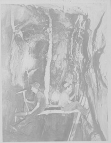
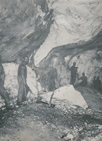
Negative - TOM PATULLO COLLECTION: MINERS UNDERGROUND
Negative print. Miners Underground. Two miners sitting on a pole underground, which straddles a shaft,one with a pick, the other with a hammer.cottage, miners, miners underground., miners underground. -
 Bendigo Historical Society Inc.
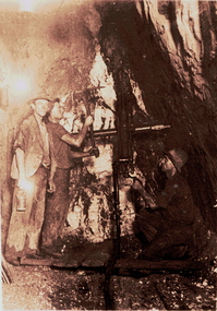
Slide - ALBERT RICHARDSON COLLECTION: TWO MINERS WORKING UNDERGROUND
Slide. .Two miners working underground.mine, gold, miners underground., bendigo mines-jack hattam collection. -
 Clunes Museum
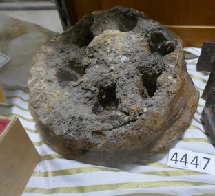
Tool - PICK
METAL MINER'S PICK USED UNDERGROUNDNilminer's pick, mining tool -
 Bendigo Historical Society Inc.
Photograph - CENTRAL DEBORAH MINE (UNDERGROUND), early 1900's?
Negative of image : 1000 feet underground at Deborah.topic, mining, central deborah mine -
 Stawell Historical Society Inc
Memorabilia - Realia, c1900's
Mining Relic found underground - Trolley Wheelstawell -
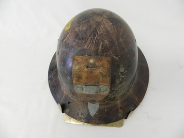 Kiewa Valley Historical Society
Helmet Safety, circa mid to late 1960's
This helmet worn by SEC Victoria workers in the Kiewa Hydro Electricity Scheme is a mandatory safety requirement by all personnel employed by government and statutory agencies who worked on or around "dangerous" apparatus or underground location sites. This type of pressed fibre helmet was later superseded by moulded plastic helmets. The start of the project (late 1940's) was not greatly covered by later introduced health and safety regulations. This has been demonstrated by photos of workmen outside using heavy machinery and other apparatus, see KVHS 0396, KVHS 0405 and KVHS 0392. However in the tunnels and underground safety helmets were mandatory, see KVHS 0403.This safety helmet was used by workers during construction of the generators and tunnels of the Kiewa Hydro Scheme was issued once only to each worker during his employment covering the 1940's to 1960's period. The attitude to health and safety during this period, can be summed up by this "initiation" ritual. When the helmet had been instrumental in saving a bad accident to a worker, that worker would be "invested" into the "Turtle Club". Although a safety helmet was only issued once to a worker this changed when modern moulded plastic helmets and greater Health and Safety requirements were introduced. Helmets now are replaced bi-annually.This safety helmet is made from pressed fibres with eyelets for airflow to the head. On the base of the helmet (before the rim) are 15 metal eyelets and three quarters up are six other eyelets (3 on each side). A thick leather strap is fastened by two rivettes to the main helmet. This strap has a metal bar rivetted on to affix a "safety" lamp, for underground work (Tunneling). There are two additional metal prongs and a metal bar to secure the lamp on the rim of the front of the helmet.sec vic kiewa hydro scheme, alternate energy supplies, alpine population growth -
 Bendigo Historical Society Inc.
Photograph - TOM PATULLO COLLECTION: MINERS UNDERGROUND
Photograph, five miners-underground in a mine with their picks and shovels.cottage, miners, miners underground, miners underground -
 Bendigo Historical Society Inc.
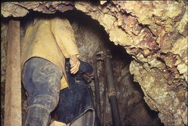
Slide - ALBERT RICHARDSON COLLECTION: MINERS DRILLING UNDERGROUND
Slide. Two workers drilling underground, standing on a platform.mine, gold, two drillers, underground., bendigo mines-jack hattam collection. -
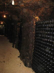
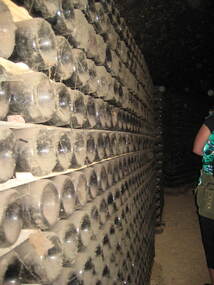 Ballarat Heritage Services
Photograph - Colour, Clare Gervasoni, Great Western Winery, 2010, 10/12/2010
Colour photograph of the underground cellar at great Western Winery.great western winery, winery, wine -
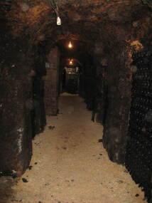
 Ballarat Heritage Services
Photograph - Colour, Clare Gervasoni, Great Western Winery, 2010, 10/12/2010
Colour photograph of the underground cellar at great Western Winery.great western winery, winery, wine -
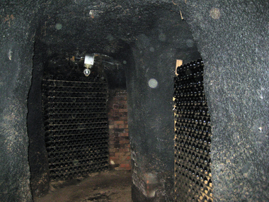
 Ballarat Heritage Services
Photograph - Colour, Clare Gervasoni, Great Western Winery, 2010, 10/12/2010
Colour photograph of the underground cellar at great Western Winery.great western winery, winery, wine -
 Ballarat Heritage Services
Photograph - Colour, Clare Gervasoni, Great Western Winery, 2010, 10/12/2010
Colour photograph of the underground cellar at great Western Winery.great western winery, winery, wine -
Stawell Historical Society Inc
Map, Stawell Gold Mines Pty Ltd, Plan of Magdala Mine. May 1994, May 1994
Moonlight Junction, Big Newington Co. Pleasants Creek and Newington, Prince Patrick, North Cross Extended, Prince Alfred, Robson and Party, North Magdala, Galatea and Pioneer Co., Duke Magdal, Moonlight, Moonlight Extended, Sliding Shaft, Extended Cross, Crown Cross United, Great Northern, Sloanes and Scotchmans, Marinees, North Waterloo, Scothmans United, Waterloo, Scotchmans Iron Duke and Bulcher, Perthen Shire, Prince of Wales, Roberts, Shafts of Rose of Denmark, Emerald Isle Shafts, O'Donnels, Darlington,, Albion, Federal, Ulster, Goldenpoint and Wexford.AO Printed Map In Colour. Showing Underground Workings and PortalScale 1 : 2500 -
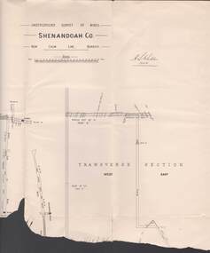 Bendigo Historical Society Inc.
Map - STRUGNELL COLLECTION: UNDERGROUND SURVEY OF MINES, BENDIGO, 20-3-01
Map, Underground Survey of Mines, Bendigo.Shenandoah Co., New Chum Line,H.S.Whitelawmap, bendigo, shenandoah co. -
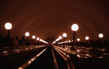 Robin Boyd Foundation
Slide, Robin Boyd, 1964
In 1964, Robin and Patricia Boyd spent several weeks on a world tour - Boyd took a leading role at the International Design Conference in Aspen and he also visited Chicago, Yale University, and New York’s World Fair. The Boyds then travelled on to England, Finland (especially to see Tapiola), Russia and India to see Le Corbusier's Chandigarh, and also Hong Kong and Thailand.Colour slide in a mount. Escalators into underground tube station, London, EnglandMade in Australia / 6 / AUG 64M / 13 (Handwritten)london, robin boyd, slide -
Stawell Historical Society Inc
Map, Geological Survey Office, Sloanes & Scotchmans united Mine, December 1916
Sloane & Scotchman's Geological Survey Map 1916 Showing Underground DrivesGeological Survey Office Ballarat December 1916 mining, gold, map -
Stawell Historical Society Inc
Map, Western Mining Corp / Stawell Joint Venture, Three dimensional View of Wonga Open Cut & Decline, April 1992
Cutaway perspective showing DeclinesView Looking North West with Cut Away Showing Underground Development Floorplanmining, gold -
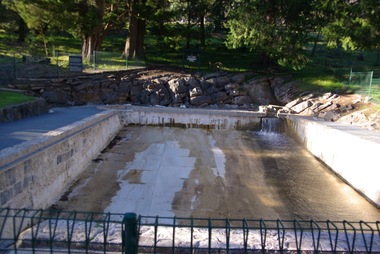 Ballarat Heritage Services
Photograph - Colour, Clare Gervasoni, A.E. Lind Pool, 2011, 28/08/2011
Colour photographs of the Buchan Swimming Pool which is filled by a natural underground stream.a.e. lind pool, buchan swimming pool, buchan, pre-olympic swimming pool -
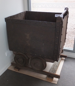 Stawell Historical Society Inc
Memorabilia - Realia, 1880-1900
Underground Mining Trolley with Four Wheels. Type used in Stawell (From Queensland) stawell -
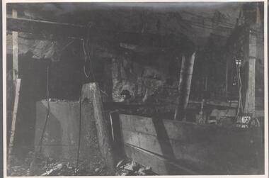 Bendigo Historical Society Inc.
Photograph - Carshalton Gold Mine Scraper, 1935
Significant to mining history of Bendigo.Black and white photograph : image shows underground position of scraper at No. 5 plat. Written in pencil on back of photograph in pencil: 'Carshalton No. 5 plat showing fixed scraper in position 17.9.35 'carshalton gold mine -
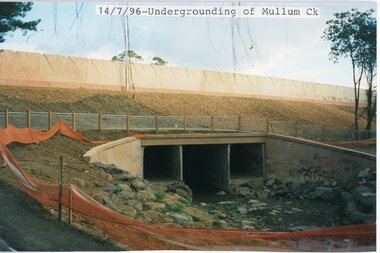 Ringwood and District Historical Society
photograph, Eastlink Ringwood Bypass Construction-Undergrounding of Mullum Ck 14/7/96
Colour photographWritten on back of photo: "Undergrounding of Mullum Ck-Ringwood Bypass 14/7/96" -
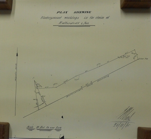 Bendigo Historical Society Inc.
Document - MARKS COLLECTION: UNDERGROUND WORKINGS BALLERSTED & SON
Plan on white paper (copy) of underground workings. On top of plan 'Plan Showing Underground Workings in the claim of Ballerstedt & Son' On bottom date written 29/11/65. Plan shows lease peg, southern boundary of claim.bendigo, mining, ballerstedt & co -
 Whitehorse Historical Society Inc.
Photograph, Mitcham Railway Station construction 2013-14
The original Mitcham Station was opened on 25th December 1882. Until the 1970s a shunting yard and goods shed existed where the southern car park is now. Tracks remained embedded in the car park for many years. In 1979 boom gates were provided at both Mitcham Road and Rooks Road. From December 2009 to January 2010 Mitcham Railway Station was used as a bus interchange when the realignment of tracks and construction of a new station occurred at Nunawading. The new Mitcham Station opened on 25th January 2014.Coloured photographs of the construction of the underground railway station at Mitcham in 2013-14 and the opening in 2014.mitcham railway station construction 2013-14, mitcham railway station opening 2014, mitcham railway station, rialway stations -
Bendigo Historical Society Inc.
Photograph - AUSTIN COLLECTION: Ray Beer, Central Deborah Gold Mine
Ray Beer was an employee of the Central Deborah Gold Mine. February 15th 2009: Bendigo Advertiser: 'MINING stalwart Raymond Beer has died at the age of 74 after a battle with cancer. He leaves behind an extended family and a legacy in Bendigo’s mining history. Ray was mine manager at the Central Deborah Gold Mine - appointed in 1978 - and led the team that made possible the underground project at the second level. He had a vision to allow visitors to go underground and experience Bendigo’s mining heritage first hand. Ray was responsible for developing the new battery, shaft and poppet head to make this a reality. It took persistence and lots of hard work. Friend and work colleague Bill McNamara said Ray was as good as 10 men. His enthusiasm and work ethic were unprecedented. Ray will be sadly missed by his wife, Thelma, six children, 15 grandchildren, seven brothers, three sisters, his extended family, and friends. He will be remembered for his kindness, tenacity and strength of character. In recognition of his contribution to Bendigo’s mining history, after more than 20 years of service at his retirement, a bronze life-sized statue was unveiled in his honour'. Central Deborah Gold Mine history: At its peak, Central Deborah Gold Mine reached a depth of 412 metres. It has 17 separate levels and 15 kilometres of drives and cross cuts (tunnels). The Central Deborah was very much a hands-on mine and the conditions that the miners worked in would be considered shocking by today's standards – being lowered underground in a cage with only two sides, often working ankle to knee deep in water, filling up to 32 ore trucks a shift by hand which were then pushed a mile or more along rails in the drives, working by carbide lamp, breathing in the fumes and rock dust and communication by bells. Geez, they were ironmen. However, at the time working conditions were considered to be among the best on the goldfields at Central Deborah, after all it was one of the only mines that had hot showers. Following Central Deborah Gold Mine's closure, the Bendigo skyline began to noticeably change. Obvious remnants of mining such as poppet heads, engine rooms, service quarters, battery houses and chimneys were steadily disappearing. After intense lobbying by the local community, the Bendigo City Council purchased the still very much intact Central Deborah Gold Mine in 1970 for a mere $6,000 to ensure that a vital link to Bendigo's historic golden past was maintained. The Bendigo Trust was then formed to oversee the operations of the Central Deborah Gold Mine, which led to the surface of the mine being opened to the public in 1971. Initially the surface was open for just 12 hours a week and as the demand for viewing a part of Bendigo's history increased, so did the opening hours. In 1974 the mine was gazetted as a Public Historical Purposes Reserve and attracted such visitors as H.R.H Prince Charles. By far the greatest shortcoming at this stage was that no one could view the underground workings, as these had become flooded. After what could only be described as a monumental effort by everyone involved, Level 2 of the mine was officially opened to the public by the Premier of Victoria, the Honourable John Cain, on 20 June 1986, which brought to fruition a long standing dream.Black and white photograph. Ray Beer, underground at Central Deborah Gold Mine, standing alongside wooden sign 'Murrell's Corner'. Sign is placed horizontally on timber supports; side of drive visible in background. Ray is wearing bib and brace overalls and hard hat with a belt around his waist. He is giving a 'thumbs up' sign. gold mining, central deborah gold mine, ray beer, mine manager -
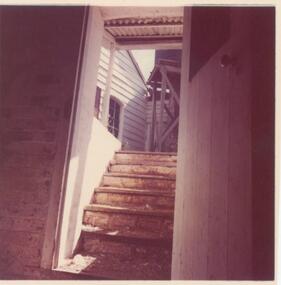 Phillip Island and District Historical Society Inc.
Photograph, 1978/9
The brick half Cellar, built by Samuel Amess for butter making and to keep meat - produce cool. On the side of the Cellar is a quotation "Gaze sadly here but shed no fear, their duty done they brought good cheer."Coloured photograph showing steps leading down to the underground Cellar situated beside "Rogers' Cottage"local history, photographs, buildings - historical, rural industry, coloured photograph, john cook, churchill island, rogers cottage cellar -
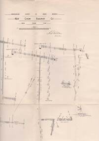 Bendigo Historical Society Inc.
Map - STRUGNELL COLLECTION: UNDERGROUND SURVEY OF MINES, BENDIGO, 25-5-01
Map, Underground Survey of Mines, Bendigo, New Chum Railway Co, New Chum Line.A.S.Whitelawmap, bendigo, new chum railway co. -
 Whitehorse Historical Society Inc.
Photograph, Schwerkolt Cottage
Coloured photo of Schwerkolt Cottage, Deep Creek Road, Mitcham. Underground well and pump in foregrounds,schwerkolt cottage -
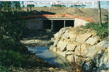 Ringwood and District Historical Society
photograph, Eastlink Ringwood Bypass Construction-Mullum Ck Undergrounding-Suda Av 21/1/96
Colour photographWritten on back of photo: "Mullum Ck Undergrounding-Suda Av end 21/1/96" -
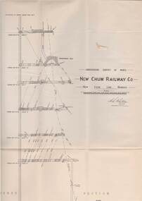 Bendigo Historical Society Inc.
Map - STRUGNELL COLLECTION: UNDERGROUND SURVEY OF MINES, BENDIGO, 29-3-01
Map, Underground Survey of Mines, New Chum Railway Co., New Chum Line, Transverse Section.A.S.Whitelawmap, bendigo, new chum railway co. -
Clunes Museum
Map - MAPS/DOCUMENTS
INFORMATIONDOCUMENTATION AND MAPS DESCRIBING THE WORKINGS OF THE PORT PHILLIP MINE, SHOWING 54 FEET DEEP OF THE UNDERGROUND WORKINGS.local history, mining, port phillip mine