Showing 228 items
matching william english
-
 Victorian Aboriginal Corporation for Languages
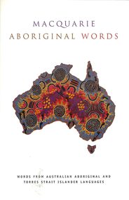
Book, Nick Thieberger, Macquarie Aboriginal words, 2007
A non-technical introduction and survey of seventeen Australian languages from across the continent; various authors. Simple grammatical information and wordlists organised by meaning. Introduction describing characteristics of Australian languages and relationship to kinship systems, address list of language centres, each language chapter has introduction, notes on wordlist, spelling and pronunciation, grammar and extensive wordlist in 26 or more categories; language index and English index; chapters annotated separately.Word lists, mapslinguistics, glossaries, vocabularies -
 Victorian Aboriginal Corporation for Languages
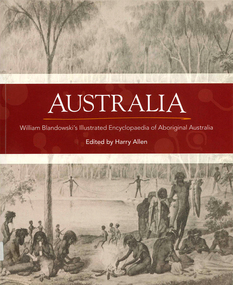
Book, Harry Allen, Australia : William Blandowski's illustrated encyclopaedia of Aboriginal Australia, 2010
William Blandowski was an explorer, natural scientist and artist who led a Victorian government expedition to the junction of the Murray and Darling Rivers from 1856 to 1857. This is the first publication in English of his nineteenth century illustrated encyclopaedia of Aboriginal life.Maps, b&w illustrationsaboriginal australian history, pictorial histories, william blandowski -
 Victorian Aboriginal Corporation for Languages
Book, Harry Allen, Australia : William Blandowski's illustrated encyclopaedia of Aboriginal Australia, 2010
William Blandowski was an explorer, natural scientist and artist who led a Victorian government expedition to the junction of the Murray and Darling Rivers from 1856 to 1857. This is the first publication in English of his nineteenth century illustrated encyclopaedia of Aboriginal life.b&w illustrations, mapswilliam blandowski, pictorial works -
 Victorian Aboriginal Corporation for Languages
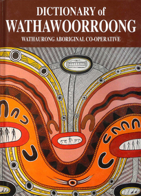
Book, Bruce Pascoe et al, Dictionary of Wathawoorroong, 2008
Dictionary with text in English and Wathawoorroong dialect.maps, b&w photographs, word listswathawoorroong, wathaurong, wathawurrung, wathaurong aboriginal co operative, kulin nation, aireys inlet, colac, ballarat, werribee, geelong, dictionaries, language map, victorian aboriginal corporation for languages, language reclamation, endangered languages, william buckley, francis tuckfield, william thomas, george augustus robinson, frances sievwright, barry blake, stephen morey -
 Uniting Church Archives - Synod of Victoria
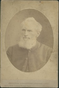
Photograph, Undated c.1880
Rev. William P. Wells (1826 - 1895) Born Marton, Lincolnshire 1826. Probationer of the English Methodist Conference 1850. Appointed to a mission circuit in Newfoundland. Returned to England in 1852. Sent to Melbourne in 1854. President of the South Australian Conference and later President of the Victorian Conference. President of Prince Alfred College, South Australia. Started the Methodist Building and Loans Fund. Codified Methodist laws and regulations. Served as minister in Castlemaine, Melbourne West, Melbourne East, Geelong, St. Kilda, Sandhurst, Hawthorn. Died 21 December 1895.Sepia toned head and shoulders oval inset studio portrait of the Rev. William P Wells.rev. william p. wells, president of conference, prince alfred college, methodist, minister, building and loans fund -
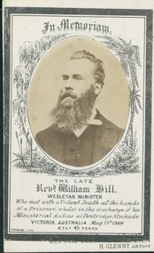 Uniting Church Archives - Synod of Victoria
Photograph, c.1869
Born Wolverhampton July 24 1826. Converted to Methodism in 1841. Trained at the Theological Institution at Richmond, U.K. Appointed as missionary to Ceylon by the 1850 English Conference. Returned to England due to ill health. Arrived in Victoria in 1854. Appointed Chairman of Castlemaine and Sandhurst District. Murdered by a prisoner at Pentridge Prison on May 13 1869. Oval, sepia toned head and shoulders studio portrait of Rev. William Hill, mounted on B & W lithographed in memoriam card.In Memoriam The Late Revd. William Hill Wesleyan Minister Who met with a Violent Death at the hands of a Prisoner, whilst in the discharge of his Ministerial duties at Pentridge Stockade. VICTORIA. AUSTRALIA. May 13th 1869. AETAT 45 yearswilliam hill, methodist, minister, ceylon, missionary, murdered, pentridge prison -
 National Wool Museum
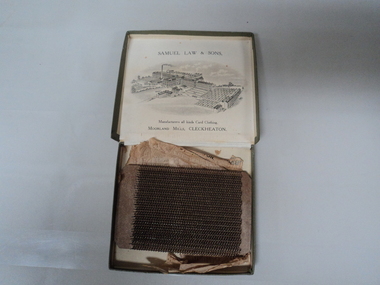
Sample, Card Clothing
Card clothing sample manufactured by Samuel Law and Sons, Cleckheaton and probably sent to the Collins Bros Mill at the same time as W621. Card clothing is defined as 'the leather or other stiff material which holds the wire staples, the points of which project outwardly and form the carding teeth which operated on the fibres.' This fits into a carding machine ("The Textile Industries" vol. 8 - William S. Murphy, 1911).Card clothing sample, comprising rows of bent wires mounted on a thick rectangular leather base. Wrapped in tissue printed with an engraving of the factory where it was made and housed in an olive green lidded cardboard box, the interior of which is printed with an image of the manufacturer's factory.SAMUEL LAW & SONS, / Manufacturers all kinds Card Clothing. / Moorland Mills. / CLECKHEATON, England. SAMPLE OF CARD CLOTHING / FROM / SAMUEL LAW & SONS, / (branch of the English Card Clothing Company, Limited). / CLECKEATON. / MOORLAND MILLSsamuel law and sons collins bros mill pty ltd, carding, card clothing -
Koorie Heritage Trust
Book, Robertson, Craig, Buckley's Hope : the real life story of Australia's Robinson Crusoe, 1981
... a young English convict named William Buckley escaped from ...Blurb: On Boxing Day 1803 a young English convict named William Buckley escaped from Victoria's abortive first settlement, at Sorrento. For the next thirty-two years Buckley survived in the wild, mainly because he was adopted and helped by the local tribes. In 1835 Buckley rejoined the civilization he had cast aside, emerging to meet Melbourne's founders. He became an important guide and interpreter in the crucial first years of the European conquest of the Port Phillip region. Then, as the Aborigines were engulfed by the flood of white men, Buckley found himself in no-man's land, mistrusted by his former black friends and by the white society who so misunderstood them. He was reviled, so harshly that his reputation has suffered to this day. This is William Buckley's story. It is a story based on fact, about a real Robinson Crusoe who was unique in Australia's history. And it is also a story of European intruders imposing their savage will on an alien, ancient continent. Rarely has Australian history come more alive than in the pages of this remarkable first novel. Buckley's life with the Aboriginal people of Port Phillip between 1803 and 1835; subsequent life in white community ; includes glossary of Aboriginal words (p. 271-280).288 p. : 3 maps ; 22 cm.Blurb: On Boxing Day 1803 a young English convict named William Buckley escaped from Victoria's abortive first settlement, at Sorrento. For the next thirty-two years Buckley survived in the wild, mainly because he was adopted and helped by the local tribes. In 1835 Buckley rejoined the civilization he had cast aside, emerging to meet Melbourne's founders. He became an important guide and interpreter in the crucial first years of the European conquest of the Port Phillip region. Then, as the Aborigines were engulfed by the flood of white men, Buckley found himself in no-man's land, mistrusted by his former black friends and by the white society who so misunderstood them. He was reviled, so harshly that his reputation has suffered to this day. This is William Buckley's story. It is a story based on fact, about a real Robinson Crusoe who was unique in Australia's history. And it is also a story of European intruders imposing their savage will on an alien, ancient continent. Rarely has Australian history come more alive than in the pages of this remarkable first novel. Buckley's life with the Aboriginal people of Port Phillip between 1803 and 1835; subsequent life in white community ; includes glossary of Aboriginal words (p. 271-280).buckley, william, 1780-1856 -- fiction. | novels in english. australian writers, 1945-. texts | convicts -- australia -- history -- fiction. | history - biographies - non-indigenous | settlement and contacts - penal colonies / convicts | settlement and contacts - colonisation - 1788-1850 | race relations - attitudes | language - vocabulary - word lists | kurnai / gunai people (s68) (vic sj55) | port phillip / western port area (vic sj55) -
National Wool Museum
Book, Sheepmates
"Sheepmates" - William Hatfield, Angus & Robertson, 1946. Novel re: life on a wool growing property in the Australian outback for an English immigrant.wool growing, hatfield, mr william -
Koorie Heritage Trust
Book, Blandowski, William, Australia : William Blandowski's Illustrated Encyclopedia of Aboriginal Australia, 2010
Blandowski's "Australia" is simultaneously an encyclopedia of Aboriginal life, a visual record of Blandowski's travels from 1849 to 1857 and a collage which combines photograghs, original images and the works of other artists. William Blandowski was an explorer, natural scientist and artist who led a Victorian government expedition to the junction of the Murray and Darling Rivers from 1856 to 1857. This is the first publication in English of his nineteenth century illustrated encyclopaedia of Aboriginal life.v-vii, 188 P. map, ill. notes; photographs; facs. plates; footnotes; timeline; annotations.Blandowski's "Australia" is simultaneously an encyclopedia of Aboriginal life, a visual record of Blandowski's travels from 1849 to 1857 and a collage which combines photograghs, original images and the works of other artists. William Blandowski was an explorer, natural scientist and artist who led a Victorian government expedition to the junction of the Murray and Darling Rivers from 1856 to 1857. This is the first publication in English of his nineteenth century illustrated encyclopaedia of Aboriginal life.aboriginal australians -- murray river valley (n.s.w.-s. aust) -- social life and customs -- 19th century -- pictorial works. | aboriginal australians -- murray river valley (n.s.w.-s. aust) -- rites and ceremonies -- 19th century -- pictorial works. | material culture. | hunting, gathering and fishing. | body - scarification. | ceremonies. | recreation - games. | weapons - clubs and fighting sticks - fighting. | death - mortuary customs. | death - mortuary / funeral ceremonies - burial. -
 Whitehorse Historical Society Inc.
Functional object - Kidney Bowl
Medical kidney dish used by William Harrison, a member of St. John's Ambulance. Equipment used when attending public functions. Used at Morton Park and Blackburn Football Club. 1946+White enamel kidney dish with blue/black edging.|Oral History is at NP3400 and Transcription is at ND6056Geddes Pharmacy - Carlton/G.H. Zeal/English mademedicine, nursing -
 Dandenong/Cranbourne RSL Sub Branch
Durban South Africa Drivers Licence
It appears that Mr WA Benville was born in/near Durban South Africa on 6th Oct 1884. He served for Her Majesties Services for 222 days in the Boer war then came to Australia. He worked as Electrician at the GPO and lived at 180 High St.Kilda and joined the Australian Imperial Force, Australian flying Corps on 26/6/1917. Service No, 2320. Rank,.Air Mechanic 2nd Class. Roll Title Flying Corps Conflict Operation, First World War 1914-1918. Mr Benville Departed Melbourne on HMAT Port Sydney A15 on 9/11/1917. He was Married to Mrs Emily Madge Benville when he enlisted in Australia. Mrs Benville died on 10th July 1947. ( Buried at the Cheltenham Cemetery) Mr William Arthur Benville Died on 28th August 1976. Rest In Peace. Drivers licence to drive a Motor Car "William Arthur Benville" Natal Province District of Durban South Africa. Pink Cover.(The licence is written in English on left and Afrikaans on right. [We have used the English Inscriptions] Natal Province-Motor Vehicle and Road Traffic Regulation Ordinance 1937. (Ordinance No. 10 of 1937 as amended) Drivers Licence class of motor vehicle in which respect licence is granted Motor Car. 123659. Issued to Surname Benville, Christian Name William Arthur, Address 178 Florida Rd, Date of Birth 6.10.84, Fee Paid 10/- shillings This licence is hereby granted to the abovenamed person, whose photograph and signature (or right thumb impression) appear hereunder, to drive a motor vehicle of the class described above. (Signature) ?????? Registrar District DURBAN , Date 26Sep 1951 ( Line undecipherable ) he must present his licence at any revenue or borough licencing office for amendment. Change of Address Date New Address Recorded by. Endorsements PN 363-P. 15593/NW.756/4,000/22-6-49 -
 Ballarat Heritage Services
Photograph - Colour, Stonework, Old Sarum, England, English Heritage Site, 01 November 2016
William the Conqueror inherited Old Sarum from the last Saxon king of England. It was an ideal site for a royal castle. It was here in 1070 that William paid off his army after a long and bitter campaign in northern England. It was here in 1086 that he called together all the major landholders in England so they could swear allegiance to him. It was a crucial moment. The Domesday Book was being written, a threatened Viking invasion had only just been averted and William's eldest son was in armed rebellion. Old Sarum was an important place where this Norman king of England held power. In 1794 the Ordnance Survey set out to check the accuracy of the first mapping of Southern England, which had begun ten years earlier. From a point just below Old Sarum Lieutenant William Mudge laid out a base-line 36,574 feet (11,253 metres) long. From each end of the line the positions of distant places were plotted using a huge theodolite made in 1791 by Jesse Ramsden. The accuracy of the process, which was repeated all over England, depended on Jesse Ramsden's craftsmanship and on William Mudge's surveying skill in setting out this first base-line from Old Sarum. The nearer end of Mudge's line is marked by an inscribed stone beside the modern A345 at Old Sarum. ordnance survey, william mudge, jesse ramsden, william the conqueror, old sarum, saxon, 1086, england -
 Ballarat Heritage Services
Photograph - Colour, Stonework, Old Sarum, England, English Heritage Site, 2016, 01 November 2016
William the Conqueror inherited Old Sarum from the last Saxon king of England. It was an ideal site for a royal castle. It was here in 1070 that William paid off his army after a long and bitter campaign in northern England. It was here in 1086 that he called together all the major landholders in England so they could swear allegiance to him. It was a crucial moment. The Domesday Book was being written, a threatened Viking invasion had only just been averted and William's eldest son was in armed rebellion. Old Sarum was an important place where this Norman king of England held power. In 1794 the Ordnance Survey set out to check the accuracy of the first mapping of Southern England, which had begun ten years earlier. From a point just below Old Sarum Lieutenant William Mudge laid out a base-line 36,574 feet (11,253 metres) long. From each end of the line the positions of distant places were plotted using a huge theodolite made in 1791 by Jesse Ramsden. The accuracy of the process, which was repeated all over England, depended on Jesse Ramsden's craftsmanship and on William Mudge's surveying skill in setting out this first base-line from Old Sarum. The nearer end of Mudge's line is marked by an inscribed stone beside the modern A345 at Old Sarum. ordnance survey, william mudge, jesse ramsden, william the conqueror, old sarum, saxon, 1086, england -
 Ballarat Heritage Services
Photograph - Colour, Stonework and well, Old Sarum, England, English Heritage Site, 2016, 01 November 2016
William the Conqueror inherited Old Sarum from the last Saxon king of England. It was an ideal site for a royal castle. It was here in 1070 that William paid off his army after a long and bitter campaign in northern England. It was here in 1086 that he called together all the major landholders in England so they could swear allegiance to him. It was a crucial moment. The Domesday Book was being written, a threatened Viking invasion had only just been averted and William's eldest son was in armed rebellion. Old Sarum was an important place where this Norman king of England held power. In 1794 the Ordnance Survey set out to check the accuracy of the first mapping of Southern England, which had begun ten years earlier. From a point just below Old Sarum Lieutenant William Mudge laid out a base-line 36,574 feet (11,253 metres) long. From each end of the line the positions of distant places were plotted using a huge theodolite made in 1791 by Jesse Ramsden. The accuracy of the process, which was repeated all over England, depended on Jesse Ramsden's craftsmanship and on William Mudge's surveying skill in setting out this first base-line from Old Sarum. The nearer end of Mudge's line is marked by an inscribed stone beside the modern A345 at Old Sarum. ordnance survey, william mudge, jesse ramsden, william the conqueror, old sarum, saxon, 1086, england -
 Ballarat Heritage Services
Photograph - Colour, Stonework, Old Sarum, England, English Heritage Site, 01 November 2016
William the Conqueror inherited Old Sarum from the last Saxon king of England. It was an ideal site for a royal castle. It was here in 1070 that William paid off his army after a long and bitter campaign in northern England. It was here in 1086 that he called together all the major landholders in England so they could swear allegiance to him. It was a crucial moment. The Domesday Book was being written, a threatened Viking invasion had only just been averted and William's eldest son was in armed rebellion. Old Sarum was an important place where this Norman king of England held power. In 1794 the Ordnance Survey set out to check the accuracy of the first mapping of Southern England, which had begun ten years earlier. From a point just below Old Sarum Lieutenant William Mudge laid out a base-line 36,574 feet (11,253 metres) long. From each end of the line the positions of distant places were plotted using a huge theodolite made in 1791 by Jesse Ramsden. The accuracy of the process, which was repeated all over England, depended on Jesse Ramsden's craftsmanship and on William Mudge's surveying skill in setting out this first base-line from Old Sarum. The nearer end of Mudge's line is marked by an inscribed stone beside the modern A345 at Old Sarum. ordnance survey, william mudge, jesse ramsden, william the conqueror, old sarum, saxon, 1086, england -
 Ballarat Heritage Services
Photograph - Colour, Sign Explaining toilets, Old Sarum, England, English Heritage Site, 01/11/2016
William the Conqueror inherited Old Sarum from the last Saxon king of England. It was an ideal site for a royal castle. It was here in 1070 that William paid off his army after a long and bitter campaign in northern England. It was here in 1086 that he called together all the major landholders in England so they could swear allegiance to him. It was a crucial moment. The Domesday Book was being written, a threatened Viking invasion had only just been averted and William's eldest son was in armed rebellion. Old Sarum was an important place where this Norman king of England held power. In 1794 the Ordnance Survey set out to check the accuracy of the first mapping of Southern England, which had begun ten years earlier. From a point just below Old Sarum Lieutenant William Mudge laid out a base-line 36,574 feet (11,253 metres) long. From each end of the line the positions of distant places were plotted using a huge theodolite made in 1791 by Jesse Ramsden. The accuracy of the process, which was repeated all over England, depended on Jesse Ramsden's craftsmanship and on William Mudge's surveying skill in setting out this first base-line from Old Sarum. The nearer end of Mudge's line is marked by an inscribed stone beside the modern A345 at Old Sarum. Colour photograph of a sign explaining toilets at Old Sarum, English Heritage Siteordnance survey, william mudge, jesse ramsden, william the conqueror, old sarum, saxon, 1086,, england -
 Ballarat Heritage Services
Photograph - Colour, Toilets, Old Sarum, England, English Heritage Site, 2016, 01 November 2016
William the Conqueror inherited Old Sarum from the last Saxon king of England. It was an ideal site for a royal castle. It was here in 1070 that William paid off his army after a long and bitter campaign in northern England. It was here in 1086 that he called together all the major landholders in England so they could swear allegiance to him. It was a crucial moment. The Domesday Book was being written, a threatened Viking invasion had only just been averted and William's eldest son was in armed rebellion. Old Sarum was an important place where this Norman king of England held power. In 1794 the Ordnance Survey set out to check the accuracy of the first mapping of Southern England, which had begun ten years earlier. From a point just below Old Sarum Lieutenant William Mudge laid out a base-line 36,574 feet (11,253 metres) long. From each end of the line the positions of distant places were plotted using a huge theodolite made in 1791 by Jesse Ramsden. The accuracy of the process, which was repeated all over England, depended on Jesse Ramsden's craftsmanship and on William Mudge's surveying skill in setting out this first base-line from Old Sarum. The nearer end of Mudge's line is marked by an inscribed stone beside the modern A345 at Old Sarum. ordnance survey, william mudge, jesse ramsden, william the conqueror, old sarum, saxon, 1086, england -
 Ballarat Heritage Services
Photograph - Colour, Stonework, Old Sarum, England, English Heritage Site, 2016, 01 November 2016
William the Conqueror inherited Old Sarum from the last Saxon king of England. It was an ideal site for a royal castle. It was here in 1070 that William paid off his army after a long and bitter campaign in northern England. It was here in 1086 that he called together all the major landholders in England so they could swear allegiance to him. It was a crucial moment. The Domesday Book was being written, a threatened Viking invasion had only just been averted and William's eldest son was in armed rebellion. Old Sarum was an important place where this Norman king of England held power. In 1794 the Ordnance Survey set out to check the accuracy of the first mapping of Southern England, which had begun ten years earlier. From a point just below Old Sarum Lieutenant William Mudge laid out a base-line 36,574 feet (11,253 metres) long. From each end of the line the positions of distant places were plotted using a huge theodolite made in 1791 by Jesse Ramsden. The accuracy of the process, which was repeated all over England, depended on Jesse Ramsden's craftsmanship and on William Mudge's surveying skill in setting out this first base-line from Old Sarum. The nearer end of Mudge's line is marked by an inscribed stone beside the modern A345 at Old Sarum. ordnance survey, william mudge, jesse ramsden, william the conqueror, old sarum, saxon, 1086, england -
 Ballarat Heritage Services
Photograph - Colour, looking from Stonework towards earth mounds, Old Sarum, England, English Heritage Site, 2016, 01 November 2016
William the Conqueror inherited Old Sarum from the last Saxon king of England. It was an ideal site for a royal castle. It was here in 1070 that William paid off his army after a long and bitter campaign in northern England. It was here in 1086 that he called together all the major landholders in England so they could swear allegiance to him. It was a crucial moment. The Domesday Book was being written, a threatened Viking invasion had only just been averted and William's eldest son was in armed rebellion. Old Sarum was an important place where this Norman king of England held power. In 1794 the Ordnance Survey set out to check the accuracy of the first mapping of Southern England, which had begun ten years earlier. From a point just below Old Sarum Lieutenant William Mudge laid out a base-line 36,574 feet (11,253 metres) long. From each end of the line the positions of distant places were plotted using a huge theodolite made in 1791 by Jesse Ramsden. The accuracy of the process, which was repeated all over England, depended on Jesse Ramsden's craftsmanship and on William Mudge's surveying skill in setting out this first base-line from Old Sarum. The nearer end of Mudge's line is marked by an inscribed stone beside the modern A345 at Old Sarum. ordnance survey, william mudge, jesse ramsden, william the conqueror, old sarum, saxon, 1086, england -
 Ballarat Heritage Services
Photograph - Colour, Looking from Stonework towards people walking on earth mounds, Old Sarum, England, English Heritage Site, 2016, 01 November 2016
William the Conqueror inherited Old Sarum from the last Saxon king of England. It was an ideal site for a royal castle. It was here in 1070 that William paid off his army after a long and bitter campaign in northern England. It was here in 1086 that he called together all the major landholders in England so they could swear allegiance to him. It was a crucial moment. The Domesday Book was being written, a threatened Viking invasion had only just been averted and William's eldest son was in armed rebellion. Old Sarum was an important place where this Norman king of England held power. In 1794 the Ordnance Survey set out to check the accuracy of the first mapping of Southern England, which had begun ten years earlier. From a point just below Old Sarum Lieutenant William Mudge laid out a base-line 36,574 feet (11,253 metres) long. From each end of the line the positions of distant places were plotted using a huge theodolite made in 1791 by Jesse Ramsden. The accuracy of the process, which was repeated all over England, depended on Jesse Ramsden's craftsmanship and on William Mudge's surveying skill in setting out this first base-line from Old Sarum. The nearer end of Mudge's line is marked by an inscribed stone beside the modern A345 at Old Sarum. ordnance survey, william mudge, jesse ramsden, william the conqueror, old sarum, saxon, 1086, england -
 Ballarat Heritage Services
Photograph - Colour, Stairs, Old Sarum, England, English Heritage Site, 2016, 01 November 2016
William the Conqueror inherited Old Sarum from the last Saxon king of England. It was an ideal site for a royal castle. It was here in 1070 that William paid off his army after a long and bitter campaign in northern England. It was here in 1086 that he called together all the major landholders in England so they could swear allegiance to him. It was a crucial moment. The Domesday Book was being written, a threatened Viking invasion had only just been averted and William's eldest son was in armed rebellion. Old Sarum was an important place where this Norman king of England held power. In 1794 the Ordnance Survey set out to check the accuracy of the first mapping of Southern England, which had begun ten years earlier. From a point just below Old Sarum Lieutenant William Mudge laid out a base-line 36,574 feet (11,253 metres) long. From each end of the line the positions of distant places were plotted using a huge theodolite made in 1791 by Jesse Ramsden. The accuracy of the process, which was repeated all over England, depended on Jesse Ramsden's craftsmanship and on William Mudge's surveying skill in setting out this first base-line from Old Sarum. The nearer end of Mudge's line is marked by an inscribed stone beside the modern A345 at Old Sarum. ordnance survey, william mudge, jesse ramsden, william the conqueror, old sarum, saxon, 1086, england -
 Ballarat Heritage Services
Photograph - Colour, Public toilets hidden in earth mound, Old Sarum, England, English Heritage Site, 2016, 01 November 2016
William the Conqueror inherited Old Sarum from the last Saxon king of England. It was an ideal site for a royal castle. It was here in 1070 that William paid off his army after a long and bitter campaign in northern England. It was here in 1086 that he called together all the major landholders in England so they could swear allegiance to him. It was a crucial moment. The Domesday Book was being written, a threatened Viking invasion had only just been averted and William's eldest son was in armed rebellion. Old Sarum was an important place where this Norman king of England held power. In 1794 the Ordnance Survey set out to check the accuracy of the first mapping of Southern England, which had begun ten years earlier. From a point just below Old Sarum Lieutenant William Mudge laid out a base-line 36,574 feet (11,253 metres) long. From each end of the line the positions of distant places were plotted using a huge theodolite made in 1791 by Jesse Ramsden. The accuracy of the process, which was repeated all over England, depended on Jesse Ramsden's craftsmanship and on William Mudge's surveying skill in setting out this first base-line from Old Sarum. The nearer end of Mudge's line is marked by an inscribed stone beside the modern A345 at Old Sarum. ordnance survey, william mudge, jesse ramsden, william the conqueror, old sarum, saxon, 1086, england -
 Ballarat Heritage Services
Photograph - Colour, Entrance to Public toilets hidden in earth mound, Old Sarum, England, English Heritage Site, 2016, 01 November 2016
William the Conqueror inherited Old Sarum from the last Saxon king of England. It was an ideal site for a royal castle. It was here in 1070 that William paid off his army after a long and bitter campaign in northern England. It was here in 1086 that he called together all the major landholders in England so they could swear allegiance to him. It was a crucial moment. The Domesday Book was being written, a threatened Viking invasion had only just been averted and William's eldest son was in armed rebellion. Old Sarum was an important place where this Norman king of England held power. In 1794 the Ordnance Survey set out to check the accuracy of the first mapping of Southern England, which had begun ten years earlier. From a point just below Old Sarum Lieutenant William Mudge laid out a base-line 36,574 feet (11,253 metres) long. From each end of the line the positions of distant places were plotted using a huge theodolite made in 1791 by Jesse Ramsden. The accuracy of the process, which was repeated all over England, depended on Jesse Ramsden's craftsmanship and on William Mudge's surveying skill in setting out this first base-line from Old Sarum. The nearer end of Mudge's line is marked by an inscribed stone beside the modern A345 at Old Sarum. ordnance survey, william mudge, jesse ramsden, william the conqueror, old sarum, saxon, 1086, england -
 Ballarat Heritage Services
Photograph - Colour, Masons' Marks, Old Sarum, England, English Heritage Site, 2016, 01 November 2016
William the Conqueror inherited Old Sarum from the last Saxon king of England. It was an ideal site for a royal castle. It was here in 1070 that William paid off his army after a long and bitter campaign in northern England. It was here in 1086 that he called together all the major landholders in England so they could swear allegiance to him. It was a crucial moment. The Domesday Book was being written, a threatened Viking invasion had only just been averted and William's eldest son was in armed rebellion. Old Sarum was an important place where this Norman king of England held power. In 1794 the Ordnance Survey set out to check the accuracy of the first mapping of Southern England, which had begun ten years earlier. From a point just below Old Sarum Lieutenant William Mudge laid out a base-line 36,574 feet (11,253 metres) long. From each end of the line the positions of distant places were plotted using a huge theodolite made in 1791 by Jesse Ramsden. The accuracy of the process, which was repeated all over England, depended on Jesse Ramsden's craftsmanship and on William Mudge's surveying skill in setting out this first base-line from Old Sarum. The nearer end of Mudge's line is marked by an inscribed stone beside the modern A345 at Old Sarum. ordnance survey, william mudge, jesse ramsden, william the conqueror, old sarum, saxon, 1086, england