Showing 176 items matching "197"
-
 Melbourne Tram Museum
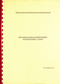
Document - Report, Melbourne & Metropolitan Tramways Board (MMTB), "Trial Installation of Barrier Kerbing, Nicholson Street - Fitzroy", Nov. 197
Report, manila covers, A4 paper, white comb binder, 30 pages, 1 photograph page of Nicholson St, looking north with a Z class tram in the distance, tables of traffic timing, looking at the impact of concrete barrier kerbs laid along the eastern side of Nicholson St Fitzroy between Alexandra Parade and Victoria Parade, 12 month trial. Report dated November 1976. Includes impact on traffic and tram services. 2nd copy added 23/10/2014.Marked number "85" in top right hand corner and stamped on cover and inside cover page "Discarded from PTC Library 22 Oct 1989". 2nd copy ex AETA marked "4E13" in top right hand corner of cover.trams, tramways, mmtb, nicholson st, fitzroy, traffic control -
 Warrnambool and District Historical Society Inc.
Trophy, Tea and Coffee Set (Cycle Trophy), Early 20th century
The Warrnambool to Melbourne/ Melbourne to Warrnambool Cycle Race is an annual event which is nationally known and attracts today international cyclists and riders from around Australia. In 1912 the ladies of Warrnambool under the direction of Mrs Younger, the Lady Mayoress, arranged to have this tea and coffee service engraved with the town crest and the relevant details so that it could be presented to the winner of the 1912 Warrnambool to Melbourne Cycle Race. But the race was not run because of a dispute between the League of Wheelmen and the race sponsor. The trophy was kept for the following year but again the race was not held. Then again in 1914 the race was cancelled because of the outbreak of World War One. So it was decided to raffle the trophy to recoup the costs. The raffle was won by Mrs Herriot and eventually the trophy ended up in Queensland with a daughter of the winner. In 197… the trophy was donated to the Warrnambool and District Historical Society. This is one of the most attractive and interesting items in our collection. It is well provenanced and is of great importance in: 1. the history of the Melbourne to Warrnambool Cycle Race. This race, of prime importance in Warrnambool’s sporting calendar and history, is the second oldest one race cycle race in the world and one of the longest one day cycle events in the world. 2. demonstrating the way the women of Warrnambool in 1912 banded together to support a premier event in the Warrnambool’s annual sporting calendar.1 Silver-soldered oval tray with fluted inside edge (has inscription) .2 Silver-soldered oval-shaped coffee pot with handle and spout .3 Silver-soldered oval-shaped tea pot with hinged lid .4 Silver-soldered bowl-shaped sugar basin with two handles and concave-shaped lid and ridged on sides .5 Silver-soldered milk jug with lid and concave-shaped handle The five items are engraved with the Town of Warrnambool crest and all have the maker’s marks on the base of the item. Tray: ‘1912 1st Prize Warrnambool to Melbourne Bicycle Race Presented by the Ladies of Warrnambool’ Base of items: ‘F HP. W. & M. 53515A, Walker and Hall, Sheffield England, Warranted Hard & Silver Soldered’. warrnambool to melbourne cycle race, melbourne to warrnambool/ -
 Kew Historical Society Inc
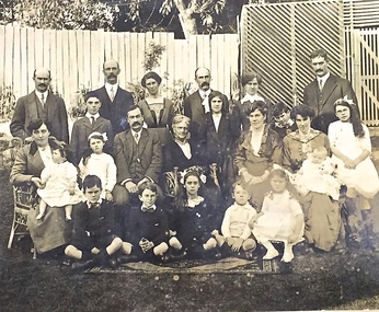
Photograph - Family portrait, The Marshall Family, 1903-1914
Captain John Marshall was born in Dundee, Scotland c.1833. Within eleven years of his arrival in Melbourne in 1852, he had established an important colonial shipping company, Anderson & Marshall, and married Mary Austin, the eldest daughter of Thomas Austin Esq of Clifton Villa in Cotham Road. Elected to the Kew Borough Council in 1869, he remained an active member until 1875. During this period, he was elected Mayor of Kew in 1872. A Scottish Protestant by birth and conviction, John Marshall was, with David Beath, a member of the inaugural committee that began planning for a separate Presbyterian Church in Kew, lending the Committee the funds to purchase land on the corner of Cotham Road and Highbury Grove. John Marshall lived at his home, 'Maryfield', at what was then 239 [now 197] Cotham Road until shortly before his death at the age of 70 in January 1903. He was buried on 14 January in Grave 493, Presbyterian Compartment A, Boroondara General Cemetery.Family portrait of the relatives of an important civic figure in Kew in the 19th century who was also a notable businessman and shipowner in the Colony of Victoria.Albumen silver photograph on card of the Marshall family grouped in three rows in a garden setting. The twenty-three members of the extended family do not include John Marshall so the photograph presumably dates from after his death in 1903. His wife, Mary Marshall, is in the middle row, five from left. marshall family, john marshall -- mayor of kew -
 Eltham District Historical Society Inc
Photograph, Liz Pidgeon, Heritage Excursion; East of Eltham, 6 Sep 2014, 20 May 2017
Newsletter No. 218, September 2014 September Excursion - East of Eltham Walk In Newsletter No. 197, March 2011, there was a brief history of Crown Allotment 15 Section 5 Parish of Nillumbik (CA 15) a parcel of land of a quarter of a square mile extending from Eucalyptus Road to Reynolds Road at the eastern extremity of Eltham. From the 1940s it was known as Stokes orchard. In later years it has been subdivided for residential purposes but leaving significant areas as power line and water supply reserves and bushland reserves that are habitat for the threatened For our excursion on 6th September we intend to walk through CA 15 to a bushland reserve east of Reynolds Road. The walk will traverse the boundary between suburban Eltham and the non-urban areas to the south and east. This is a pleasant walk through residential areas and bushland. Along the way we will discuss the early and more recent history of CA 15 as well as local natural history and geology. This walk is about 3.5 km in length and will take 2 to 2.5 hours. It will start at 2pm at the corner of Eucalyptus Road, Pitt Street and Nyora Road.Born Digitaleltham east, eltham district historical society, heritage excursion, activities, nyora road, reynolds road, gum tree road reserve, diosma road, stokes orchard, eucalyptus road -
 Eltham District Historical Society Inc
Photograph, Liz Pidgeon, Heritage Excursion; East of Eltham, 6 Sep 2014, 20 May 2017
Newsletter No. 218, September 2014 September Excursion - East of Eltham Walk In Newsletter No. 197, March 2011, there was a brief history of Crown Allotment 15 Section 5 Parish of Nillumbik (CA 15) a parcel of land of a quarter of a square mile extending from Eucalyptus Road to Reynolds Road at the eastern extremity of Eltham. From the 1940s it was known as Stokes orchard. In later years it has been subdivided for residential purposes but leaving significant areas as power line and water supply reserves and bushland reserves that are habitat for the threatened For our excursion on 6th September we intend to walk through CA 15 to a bushland reserve east of Reynolds Road. The walk will traverse the boundary between suburban Eltham and the non-urban areas to the south and east. This is a pleasant walk through residential areas and bushland. Along the way we will discuss the early and more recent history of CA 15 as well as local natural history and geology. This walk is about 3.5 km in length and will take 2 to 2.5 hours. It will start at 2pm at the corner of Eucalyptus Road, Pitt Street and Nyora Road.Born Digitaleltham east, eltham district historical society, heritage excursion, activities, nyora road, reynolds road, gum tree road reserve, diosma road, stokes orchard, eucalyptus road