Showing 1506 items matching "acres"
-
 Bendigo Historical Society Inc.
Map - CAMPBELL COLLECTION: BENDIGO AND DISTRICT MAPS, 9-4-29
Map. Campaspe, Parish of Kimbolton, Scale 20 chains to 1 inch. Total area 4117 acres, Campaspe River, Prepared in W.P.B. by W.J.Galbraith from Parish and Assessment Plans. (number 384 in map cupboard 1)W.J.Galbraithmap, bendigo, agricultural lands -
Bendigo Historical Society Inc.
Map - CAMPBELL COLLECTION: BENDIGO & DISTRICT MAPS, 14-6-29
Map. Eppalock, Sedgwick and Strathfieldsaye. Scale 20 chains to 1 inch. Total area 3972 acres. Prepared in W.P.B. from Assessment Plan and Parish Plans. H.A. Darby. (number 378 in map cupboard 1)H.A.Darbymap, bendigo, agricultural lands -
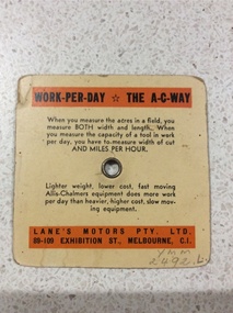 Yarrawonga and Mulwala Pioneer Museum
Tractor calculator, Unknown
A ready reckoner useful to the farmer during the 1950'sSquare orange card with rotating wheel attached by a centrre metal stud. By aligning appropriate measures on the wheel and card it tells the farmer the approx number of acres that can be worked in a ten hour day with any tool or implement.Allis Chambers tracotr calculator. Tractor speed miles per hour. Width of cut in feet of ploughs, harrows, cultivators, combines, harvesters etc (see photo) -
Whitehorse Historical Society Inc.
Document, History of Blackburn North State School No 4715, c1970
Document re establishment of Blackburn North Primary School on 5 acres of land on the North Side of Springfield Road. Opened 5 April 1954 with initial enrolment of 237 pupils, also listing staff and school committee members.blackburn north primary school, primary schools, jenkins, p, cole, j -
 Whitehorse Historical Society Inc.
Document - Correspondence, Re A.C. Huggins, 19/10/1923 12:00:00 AM
Sworn valuation and report of A. C. HugginsSworn valuation and report of A. C. Huggins situated in Mitcham Road, Mitcham for 17 October 1923. Land of 2 acres, part under orchard (Cherry), weatherboard house of 6 rooms in fair order. Value 1,450 pounds.Sworn valuation and report of A. C. Huggins land values, huggins, a. c., mitcham road, mitcham, price, charles s. -
 Kew Historical Society Inc
Plan - Subdivision Plan, Bonnie Doon Estate, c.1908
Pru Sanderson, in her groundbreaking ‘City of Kew Urban Conservation Study : Volume 2 - Development History’ (1988), summarised the periods of urban development and subdivisions of land in Kew. The periods that she identified included 1845-1880, 1880-1893, 1893-1921, 1921-1933, 1933-1943, and Post-War Development. These periods were selected as they represented periods of rapid growth or decline in urban development. An obvious starting point for Sanderson’s groupings involved population growth and the associated economic cycles. These cycles also highlighted urban expansion onto land that was predominantly rural, although in other cases it represented the decline and breakup of large estates. A number of the plans in the Kew Historical Society’s collection can also be found in other collections, such as those of the State Library of Victoria and the Boroondara Library Service. A number are however unique to the collection.The Kew Historical Society collection includes almost 100 subdivision plans pertaining to suburbs of the City of Melbourne. Most of these are of Kew, Kew East or Studley Park, although a smaller number are plans of Camberwell, Deepdene, Balwyn and Hawthorn. It is believed that the majority of the plans were gifted to the Society by persons connected with the real estate firm - J. R. Mathers and McMillan, 136 Cotham Road, Kew. The Plans in the collection are rarely in pristine form, being working plans on which the agent would write notes and record lots sold and the prices of these. The subdivision plans are historically significant examples of the growth of urban Melbourne from the beginning of the 20th Century up until the 1980s. A number of the plans are double-sided and often include a photograph on the reverse. A number of the latter are by noted photographers such as J.E. Barnes.The subdivision advertised as the Bonnie Doon Estate in Greensborough was first advertised in 1908. At that stage, the new subdivision included 15 allotments of between one and four acres. By the time the subdivision plan in the Kew Collection was created, only 12 lots of between ¾ and 2½ acres remained. Both the State Library and Kew plans emphasise the distance to the city being 13½ miles, which could be reached by train on weekdays and weekends. Unusually, the plan describes the suitability of lots as locations for ‘Week-end Homes’. Correspondingly, the train line is described as ‘The Holiday Resort for the Northern Suburbs’.bonnie doona estate, subdivision plans - greensborough -
Ringwood and District Historical Society
Envelope, Packet: School 1451 (at Ringwood East) and Ringwood 2997. History of Schools in Ringwood. Mr Edward Cass first teacher
School no.1451 1874-1894; Cass, E.F.; School 1451 moved to SS3284 Dandenong in 1900; 4 acres of old site sold to C.Molloy; "A History of Schools in Ringwood" 4 pages +Additional Keywords: Cass, E.F. / Molloy, C. -
Bendigo Historical Society Inc.
Map - CAMPBELL COLLECTION: BENDIGO AND DISTRICT MAPS, 16-4-29
Map. Kennington, Parishes of Sandhurst, Mandurang and Strathfieldsaye. Scale 20 chains to 1 inch. Total area 2918 acres. Prepared in W.P.B. from A. and C.L. Plans by W.J.Galbraith, 16-4-29. (number 394 in map cupboard 1)W.J.Galbraithmap, bendigo, allotments -
Bendigo Historical Society Inc.
Map - CAMPBELL COLLECTION: BENDIGO & DISTRICT MAPS, 22-3 29
Map. Marong, Parishes of Marong, Lockwood and Mandurang. Scale 20 chains to an inch. Total area 5106 acres. Crusoe Reservoir on right. Compiled in W.P.B. from Field Survey and Parish Plans (number 373 in map cupboard 1)G.W.Lmap, bendigo, allotments -
Bendigo Historical Society Inc.
Map - CAMPBELL COLLECTION: BENDIGO AND DISTRICT MAPS
Map. Marong, Parishes of Marong, Lockwood and Mandurang. Scale 20 chains to an inch. Total 5106 acres. Compiled in W.P.B. from Field Survey and Parish Plans. Crusoe Reservoir to the right of map. (number 362 in map cupboard 1)map, bendigo, parish plan -
Bendigo Historical Society Inc.
Map - CAMPBELL COLLECTION: BENDIGO AND DISTRICT MAPS, 6-4-28
Map. Sedgwick, Parishes of Strathfieldsaye, Lyell, and Sedgwick. Scale 20 chains to 1 inch. Total area 5372 acres. Prepared in W.P.B. from C.L.and A. Plans by W.J.Galbraith 6-4-28. (number 400 in map cupboard 1)W.J.Galbraith.map, bendigo, agricultural lands -
 Bendigo Historical Society Inc.
Document - MCCOLL, RANKIN AND STANISTREET COLLECTION: CENTRAL NELL GWYNNE, March - April 1943
Document. Manila folder & 4 letters, 1 map The 4 letters pertain to an application by the Commonwealth of Australia to the lands Depart. For sale of an area of 8 acres 0 roods 31 perches now comprising the garden of Fortuna to unlimited depth.McColl, Rankin & Stanistreetorganization, business, central nell gwynne, mccoll, rankin & stanistreet, central nell gwynne gmc, south nell gwynne, gold mining, dept of mines -
 Whitehorse Historical Society Inc.
Document, Canterbury Road Tunstall, 29/01/19?5
Photocopy of letter to the Commercial Bank, Prahran re land and property valuation occupied by Mr Sliegner, north side of Canterbury Road, Tunstall (Now Forest Hill) close to Springvale Road. Land 2.5 acres with villa and out buildings.land values, sliegner (mr), canterbury road, forest hill, c. husband (estate agent) -
 Whitehorse Historical Society Inc.
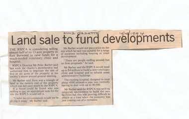
Article, Land sale to fund developments, 19/10/1994 12:00:00 AM
RSPCA plans to sell 5 or 6 acres of its East Burwood property at market value to help fund the new veterinary clinic and hospital.Newspaper article outlining RSPCA plans to sell 5 or 6 acres of its East Burwood property at market value to help fund the new veterinary clinic and hospital. The sum required to build the new hospital and clinic is $4 million. RSPCA plans to sell 5 or 6 acres of its East Burwood property at market value to help fund the new veterinary clinic and hospital. royal society for the prevention of cruelty to animals, burwood east, barber, peter, veterinary services, land sales -
 Whitehorse Historical Society Inc.
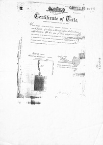
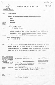
Legal record - Document, Forest Hill, 12/08/1913
Photocopy of Certificate of Title. Vol 3715 Fol. 742903 to Julius Draeger, 12 August 1913, for fifteen acres of land being part of Crown Portion 94, including plan of subdivision (P72294) cancelling title. [Contract of Sale ND567]Photocopy of Certificate of Title. Vol 3715 Fol. 742903 to Julius Draeger, 12 August 1913, for fifteen acres of land being part of Crown Portion 94, including plan of subdivision (P72294) cancelling title. [Contract of Sale ND567]Photocopy of Certificate of Title. Vol 3715 Fol. 742903 to Julius Draeger, 12 August 1913, for fifteen acres of land being part of Crown Portion 94, including plan of subdivision (P72294) cancelling title. [Contract of Sale ND567]glebe street, forest hill, land subdivision, draeger, carl julius otto, vicki street, bindy street, lee-ann street -
 Bendigo Historical Society Inc.
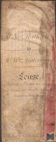
Document - INDENTURE DOCUMENT BETWEEN JAMES NORTHCOTT AND WILLIAM ANDERSON
Indenture document, hand written in ink and ruled in red ink, between James Northcott, farmer and William Anderson ' of the same place' for 380 acres at Bullock Creek. Document is in poor condition and folded in four sections. Document dated 1870.rural industry, farm property, indenture northcott and anderson -
Bendigo Historical Society Inc.
Map - CAMPBELL COLLECTION: BENDIGO AND DISTRICT MAPS, 11-4-29
Map. Huntly, Parishes of Huntly Nerring and Neilborough. Scale 20 chains to 1 inch. Total area 4738 acres. Eaglehawk. Prepared in W.J.B. from A. and C.L. Plans by W.J.Galbraith 11-4-29. (number 396 in map cupboard 1)W.J.Galbraithmap, bendigo, agricultural lands -
Bendigo Historical Society Inc.
Map - CAMPBELL COLLECTION: BENDIGO AND DISTRICT MAPS, 14-6-29
Map. Terricks, Parish of Terrick Terrick West, scale 20 chains to 1 inch, total area 6318 acres, prepared in W.P.B. from Assessment and Parish Plans by W.J.G. 14-6-29. (number 388 in map cupboard 1)W.J.Galbraithmap, bendigo, agricultural lands -
Bendigo Historical Society Inc.
Map - CAMPBELL COLLECTION: BENDIGO AND DISTRICT MAPS
Map. Kimbolton, Parishes of Kimbolton and Lyell, scale 20 chains to 1 inch. Area by Planimeter 6258 acres. Knowsley. 10 1/2 miles to Strathfieldsaye. Campaspe River at bottom right of map. (number 365 in map cupboard 1)map, bendigo, allotments -
Bendigo Historical Society Inc.
Map - CAMPBELL COLLECTION: BENDIGO AND DISTRICT MAPS, 10-5-29
Map. Mandurang, Scale 20 chains to an inch. Total area 5746 acres. Kennington, Township of Mandurang. To accompany my report of 10-5-29 R. Marshall, Forest assessor. Drawn by I.M.K. (number 399 in map cupboard 1)I.M.K.map, bendigo, allotments -
 Bendigo Historical Society Inc.
Document - KELLY AND ALLSOP COLLECTION: CORRYONG GOLD MINING SYNDICATE - CIRCULAR, 12/07/1926 to 18/08/1926
Report of the Rising Sun Lease of 25 acres situated at Lake La Page, Western Australia, over which the Company has taken an option on the recommendation of Mr. F. J. Rashleigh, who inspected and reported on the property on behalf of the option holders.Corryong Gold Mining Co.business, stockbroker, kelly & allsop, kelly & allsop collection, corryong gold mining syndicate., lake la page, r.t.trembath, fred tricks. -
 Whitehorse Historical Society Inc.
Document, Forest Hill, 1/06/1937
Photocopy of contract of sale between Julius Draeger, vendor and John Ernest Kleinert, 19 June 1937, for 15 acres of land being part of Crown Portion 94, Certificate of Title, Vol 3715 Fol 742908 (Certificate of Title ND576)land sales, draeger, carl julius otto, kleinert, john ernest, glebe street, forest hill -
 Bacchus Marsh & District Historical Society
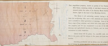
Map, Pentland Hills Estate Land Sale 1904
The Pentland Hills Estate property shown in this auction plan was put up for sale in 1904. It was a deceased estate sale. The property had been owned by Peter Grant who died in 1899. Peter Grant had worked and farmed in the Myrniong area for many years and had also been a Councillor on the Bacchus Marsh Shire for a number of terms. A property sales report in the Express newspaper recorded that the land for sale comprised 500 acres of the old Pentland Hills Estate. It was subdivided into three lots, all of which were sold at good prices. Lot l, 212 acres was sold to Messrs Thomas and Robert Lidgett of Myrniong, at £11/15/ per acre, lot 2, 200 acres, to Mr David Robertson, of Bacchus Marsh, at £9 17/0 per acre, and lot 3, 38 acres, was sold to Mr James Norton, jun at £11 per acre. A single page paper map showing a portions of land available for sale from the Pentland Hills Estate near Bacchus Marsh.The name of the seller, Mrs Grant, can seen handwritten on this map and the buyers of the three portions for sale, Lidgett lot 1, Robertson lot 2 and Morton lot 3. Parts of the text are missing along the edges due to tearing or excessive trimming of the edges. The map is pasted into a bound volume containing 76 maps or plans in total. High resolution digital image stored on BMDHS computer network. Handwritten: Mrs Grant, Myrniong, Executrix in the deceased Estate of Mr. Peter Grant to sell by public auction.land sales, pentland hills maps, myrniong area land sales, pentland hills estate -
![Map, Liquidator's sale, 1896. [Woolpack Estate, Bacchus Marsh]](/media/collectors/5e461d8021ea67224c82f2a1/items/6779ee97032b72846b5995f2/item-media/6779ef33032b72846b599b30/item-fit-380x285.jpg) Bacchus Marsh & District Historical Society
Bacchus Marsh & District Historical SocietyMap, Liquidator's sale, 1896. [Woolpack Estate, Bacchus Marsh]
The Woolpack Estate was an area of land owned by various landowners in the Bacchus Marsh area since the early Colonial period of the 1840s. The area was located on the eastern side of the Bacchus Marsh township about 7 kilometers from the town. The Lerderderg River ran through part of the land and so did the Melbourne to Ballarat Road. The historic Woolpack Inn associated with James Crook was also located on this land. By 1896 150 acres of this land was under the control of liquidators for the Federal Bank of Australasia who instructed that the land be sub-divided and sold in lots by public auction. A successful sale was held on 24 June 1896. Most of the blocks of land were sold for higher than expected prices and most of the buyers were people from the town and district of Bacchus Marsh. The map includes various details about the land which is described on the map as an "important sale of rich alluvial irrigable flat land in the Bacchus Marsh Valley, and other properties". The auction was conducted by the local agents W. Anderson and Bence in conjunction with Pearce Brothers also of Bacchus Marsh.A single page paper map showing a plan of 150 acres of land from the Woolpack Estate to be sold in various lots in June 1896. Also shown on the map are lots for sale at Robinson's Farm on Coimadai Creek and allotments near Bacchus Marsh railway station, including lots on Government Road (East Maddingley Road), View Street and Government Road (Parwan Road). No scale provided. The map is pasted into a bound volume containing 76 maps or plans in total. High resolution digital image stored on BMDHS computer network. land sales bacchus marsh, bacchus marsh victoria maps, woolpack estate bacchus marsh victoria -
Bendigo Historical Society Inc.
Map - CAMPBELL COLLECTION: BENDIGO AND DISTRICT MAPS, 8-2-29
Map. Bagshot, Parishes of Wellsford, Ellesmere, and Bagshot. Huntly 4 miles, Fosterville 3 miles. Total area 5037 acres, Prepared in W.P.B. from A.C.L and D.B. Plans, by W.J.Galbraith 8-2-29. (number 382 in map cupboard 1).W.J.Galbraithmap, bendigo, agricultural lands -
Bendigo Historical Society Inc.
Map - CAMPBELL COLLECTION: BENDIGO AND DISTRICT MAPS, 30-1-29
Map. Ellesmere, Parish of Ellesmere, scale 20 chains to 1 inch. Total area 3926 acres. Prepared in W.P.B. from A. and P. Plans, by W.J. Galbraith, 30-1-29, to Bendigo along Fosterville. (number 381 in map cupboard 1)W.J.Galbraithmap, bendigo, agricultural lands -
Bendigo Historical Society Inc.
Map - CAMPBELL COLLECTION: BENDIGO AND DISTRICT MAPS, 16-5-29
Map. Egerton, Parishes of Egerton and Whirrakee. Scale 20 chains to 1 inch. Total area 5401 acres. Prepared in W.P.B. from A. and C.L. Plans by W.J.G. 16-5-29. To Rochester 12 miles. (number 366 in map cupboard 1)W.J.G.(W.J.Galbraith)map, bendigo, allotments -
Bendigo Historical Society Inc.
Map - CAMPBELL COLLECTION: BENDIGO AND DISTRICT MAPS, 8-2-29
Map. Bagshot, Parishes of Wellsford, Ellesmere and Bagshot. Scale 20 chains to 1 inch. Total area 5037 acres. Prepared in W.P.B. from A.C.l. and D.B. Plans, W.J. Galbraith, 8-2-29 (number 353 in map cupboard 1)W.J.Galbraithmap, bendigo, agricultural lands -
Bendigo Historical Society Inc.
Map - CAMPBELL COLLECTION: BENDIGO AND DISTRICT MAPS, 12-2-29
Map. Axedale, Parishes of Ellesmere and Axedale. Scale 20 chains to 1 inch. To the west is Wellsford. Total area 4156 acres. Prepared in W.P.B. from A and P plans by W.J. Galbraith 12-2-29. (number 352 in map cupboard 1)W.J.Galbraithmap, bendigo, agricultural lands -
Bendigo Historical Society Inc.
Map - CAMPBELL COLLECTION: BENDIGO AND DISTRICT MAPS, 1929
Map. Campaspe, Parish of Kimbolton. Total area 4117 acres. Campaspe River, Kimbolton. Scale 20 chains to 1 inch. Prepared in W.P.B. form Parish and Assessment Plans. G.W.L. 9-4-29. (number 351 in map cupboard 1)map, bendigo, allotments