Showing 152 items matching "additional land"
-
 Eltham District Historical Society Inc
Photograph - Digital Photograph, Alan King, Original Kangaroo Ground Primary School No. 2105 building, Eltham-Yarra Glen Road, Kangaroo Ground, 28 December 2007
Kangaroo Ground's first school began in 1851 with 22 pupils from the district's ten families. It was a single room school located further south on the site, which also served as a Presbyterian church. The first teacher was Andrew Ross. The school building was used as a Post Office between 1854 and 1858 and during 1857 also served as a Court of Petty Sessions. With a growing farming community, a new building was warranted and the original Sate School No. 352 was closed and a new building, State School No. 2105 was oipened October 1, 1878. A residence for Head Teacher Henry Wallace School was erected in 1879 attached to the left of the school building. That residence is now home to the Andrew Ross Museum, which opened in 1993. Covered under Heritage Overlay, Nillumbik Planning Scheme. Published: Nillumbik Now and Then / Marguerite Marshall 2008; photographs Alan King with Marguerite Marshall.; p35 In a corner of the Kangaroo Ground Primary School playground stands an old weatherboard building. This structure, attached to the former teacher’s weatherboard residence facing Main Road, first served as a school in 1878. The former residence, built in 1879, houses the Andrew Ross Museum, which opened in 1993. It is named after the school’s first teacher,1 who also founded The Evelyn Observer newspaper, which began on the site in 1873. Later the printing presses were moved to brick newspaper offices by the Kangaroo Ground Hotel, which became the Shire of Eltham offices. However Kangaroo Ground’s first school began in 1851 for 22 pupils from the district’s ten families, in a slab building further south on this site. Andrew Harkness and other settlers campaigned for the building, which was built on half an acre (0.2ha) donated by local farmer, James Donaldson. Builder was Samuel Furphy, father of the novelist Joseph.2 The single room measuring 30 feet x 18 feet (9m x 5.5m), was unlined and the green slabs shrank, allowing the wind and rain entry through cracks except when they were stuffed with paper.3 The building served as a Presbyterian church as well as a school, where fees were 18 pence a week for education. Young men also attended evening classes there in winter. At one stage, a corner of the room was curtained off for the schoolmaster’s living space, and the platform, which was used for sleeping, was also the pulpit during church services. Teacher Andrew Ross also took church services when the minister was unable to attend, which happened frequently as he had long distances to travel on the bad roads. In 1857 the school building was also used as the Court of Petty Sessions, and from 1854 until 1858, it served as a post office. During the gold rush fossickers on their way to the Caledonia Diggings at Queenstown (now St Andrews) prospected the district, but did not remain long, as the fields were not rich in gold. But the farming community grew, until by 1878 the population warranted the building of State School No 2105 – the present one-roomed tongue-and-groove lined building measuring 49 feet x 18 feet (15m x 5.5m), to accommodate 60 children. The old school, No 352, was closed, and the new one opened on October 1, with Henry Wallace as head teacher, assisted by work mistress Annie Johnston. Early teachers included Messrs Smith, Hamilton and Prosser, with sewing teachers Misses Sweeney, Limerock and Oliver. In the early 1920s a small room was built on the front veranda of the teacher’s residence, and used as a State Savings Bank agency until about 1934. In 1928 the schoolroom’s three-tiered floor was replaced by a flat floor and teacher’s platform (which has since been removed). A half-glassed partition wall then divided the large room into two rooms in which the old style form-type desks were replaced with dual desks. The small playground, surrounded by pine trees and a picket fence, was extended in 1931 with an additional acre or so (0.4 ha) of land. During World War Two the school faced closure because of a fall to seven in the enrolment, but by 1946 it had increased again to 45. Mr Eric Morgan was head teacher and Mrs Margaret Banks was assistant head teacher, a position she held for ten years. In 1955, under the head teacher Mr V Gardiner, who taught there for 13 years, the school won a prize for the best-kept garden and school ground in the inspectorate. A district subdivision increased the enrolment in 1968 to 65 and a bus service was established. After the hall which had been used for lessons was demolished late that year, the pupils met in the original fire brigade meeting room (now the tennis club, diagonally opposite the general store). The new school building with a storeroom and staffroom was built in 1974.This collection of almost 130 photos about places and people within the Shire of Nillumbik, an urban and rural municipality in Melbourne's north, contributes to an understanding of the history of the Shire. Published in 2008 immediately prior to the Black Saturday bushfires of February 7, 2009, it documents sites that were impacted, and in some cases destroyed by the fires. It includes photographs taken especially for the publication, creating a unique time capsule representing the Shire in the early 21st century. It remains the most recent comprehenesive publication devoted to the Shire's history connecting local residents to the past. nillumbik now and then (marshall-king) collection, kangaroo ground, andrew ross museum, eltham-yarra glen road, kangaroo ground primary school no. 2105, kangaroo ground state school, state school no. 2105 -
 Wodonga & District Historical Society Inc
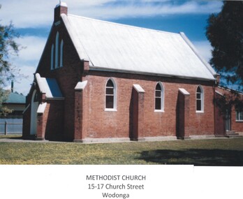
Photograph - First Methodist Church, Wodonga
Land for the Methodist Church in Wodonga was reserved in 1864. By 1865 the Reverend Francis Neale, a Wesleyan minister was appointed to Albury from where he supervised the congregation at Wodonga Creek until a church was built in 1873. By 1885 Wodonga and the other preaching places on the Victorian side of the Murray had become a separate circuit under the Reverend L. J Rowlands. This circuit included Bethanga. Kiewa. Leneva, Kergunyah and Bonegilla. In the 1960s the Methodist congregation built a new chapel in Hovell Street, Wodonga. The creation of the Uniting Church during the 1970s meant that the services were held in the former Presbyterian Church and joint Sunday School classes were conducted in the Methodist Hall. In 1961 the Church building and land was purchased by the Ukrainian Community for £2,000. Ukrainian Catholic families in Wodonga donated £100 each towards the purchase. Additional fund raising such as carol singing in nearby towns (Benalla, Wangaratta, Albury and Wodonga) assisted with the purchase of the Church. The former Methodist Church was in poor condition and the members of its new congregation undertook the replacement of the floor, the footings, replastering of the walls and the construction of an altar. The renovations cost a further £400. Once a month a priest came up from Melbourne to conduct services in the Church. On completion it was blessed by Bishop Ivan Prasko to become St Olga's Catholic Church (Ukrainian). In 1965 the Church was dedicated to its patron St Volodymir, with Bishop Varlamm (Sydney) and Bishop Donat (Melbourne) taking part in the ceremony. The members of the Ukrainian Catholic community also built a hall and smaller chapel in Hunt Street, Wodonga. With a declining congregation, this property became more manageable to maintain than the original brick building and the decision was made to close the building in 2010. In 2022 the building and extensive block of land in Church Street was sold commercially for potential redevelopment.These images are significant because they depict an early Wodonga Church building.A collection of coloured photographs depicting the first Methodist Church in Wodonga, Victoria It was a red brick church with a steeply pitched gable roof and parapeted gable walls. There was a small front porch with matching roof and gable treatment to the front. Simple timber Gothic windows were along the sides, with a tri-partite window above the porch. Two sections of this window featured stained glass, the other was opaque glass. Red brick buttresses were topped with white-painted render, as were the parapets, and the windows were also outlined with white painted render. Timber joinery was painted white. A front path led directly to the porch and the Church was flanked by mature oak trees. A small, relatively modern red brick skillion extension was added to the rear of the building.wodonga churches, methodist church wodonga, ukrainian catholic church wodonga -
 City of Kingston
Pamphlet - Colour, Arthur Tuckett & Son, Auctioneers and Subdivisional Specialists, Auction of Station Estate, Moorabbin, 1923
Sales plan for land in the suburb of Moorabbin, bounded by Railway Crescent, South Road, Jasper Road and Pattersons Road.The developing urban area of Moorabbin within the City of Kingston. This land sale pamphlet illustrates the subdivision of land within the municipality and the changing demographic of the district as new houses are constructed.Colour pamphlet advertising an auction of the Station Estate Moorabbin. Incorporates details of the shopping facilities, proximity to the railway line, variety of schools and churches in the area, and a sales plan for home sites and shop fronts. Incorporates a map of the estate bordered by Pattersons Road, Japer Road, South Road and Railway Crescent. Handwritten in grey pencil top right front page: Station Estate / late [indecipherable] Handwritten in red pencil on subdivision map: x [on majority of properties marked on the map] Handwritten in grey pencil on subdivision map: additional subdivisions drawn in and large lines drawn across the mapmoorabbin, land sales, estate -
 Bendigo Historical Society Inc.
Document - Rocky Vale Beebe House, 2010 to 2015
The Beebe name was well-known in Bendigo in the last quarter of the 19th and the early part of the 20th centuries. From 1875, William Beebe senior, monumental mason, occupied a site in the centre on the city, in Mitchell Street opposite King Street. Death was more part of life in those days, and the Beebes were there to provide the burial monuments. Later, he took his sons into the business, which grew as Beebe and Son. Many examples of their work can be found in the local cemeteries. William Beebe senior (1830-1891) was born in Rutland, the smallest English county in 1830, to stonemason Chamberlain Beebe and Susannah Clements. William emigrated to Victoria in 1854 and after engaging on unknown works in Port Fairy, Dunkeld, and Melbourne arrived in Bendigo. His obituary records that he commenced work here on the site of the Bank of Australasia (opposite the Shamrock Hotel), which would have been no later than 1856. He took up a 13 acre selection on the site of Rocky Vale Villa in 1864 and continued to select or purchase further parcels of adjoining land until he owned some 150 acres, much of it unfit for cultivation. He was a keen gardener and had a garden and orchard around the house. William took over 20 years to build the two-story sandstone and granite house "Rocky Vale Villa". The house was constructed from sandstone sourced "from an adjacent ridge of rocks" (Bendigo Advertiser 28/9/1891). Granite from Harcourt was used for lintels and quoins. Not long before he died, William was still adding to the house. In the Codicil to his will, he states that "I have just built and completed two additional rooms to my Dwelling house situe at Inglewood Road aforesaid" (dated 19/9/1891). William died one week later on the 26th September 1891.Photographs and Historical Documents relating to Rocky Vale Villa, 7 Wicks Road, Maiden Gully, Bendigo by the Bendigo Historical Society.history, bendigo, rocky vale villa maiden gully, william beebe stonemason bendigo -
 Surrey Hills Historical Society Collection
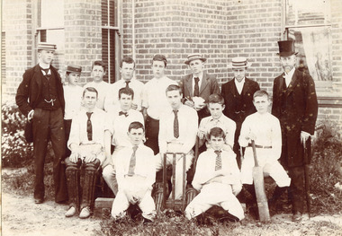
Photograph - Surrey College Cricket Team, 1899, 1899
Surrey College was opened in early 1892 by Reverend Dr Frederick Darling who had been the first minister of the Presbyterian Church in Canterbury Road. He resigned this position to open the school which operated until 1905 with additional premises at 12 Vincent Street. The main building fronted 219-233 Union Road. The school had 40 boarders as well as day boys. Courses included algebra, euclid, history, typewriting, shorthand and drill. In the 1930s, Nethercourt Private Hospital took over the site. Later it became St Jude's Hospital. Land in front of the building was sub-divided off in the 1970s. The building is still extant as a private dwelling with York Street, Surrey Hills as the address. This is one of 3 photos donated by Susan Hobbs, whose grandfather Rev. George Edward Downton is thought to have been a student at the college. George E. Downton was born in Avoca in 1885. He was later a missionary in New Guinea and Secretary to the Australian Board of Missions in Adelaide. He died in 1926 or 1927. This photo is one of two that were originally in the Box Hill Historical Society collection. They were transferred to us in 2024. The third photo could not be located. There was also a rough family tree and notes for the Downton family with correspondence regarding the donation but this was not found.Sepia photograph on grey mount board of 15 men and boys. Eleven of the boys are dressed in whites, 5 wearing ties and 1 a bow tie, one with a boater and one with a cap. The boy seated on the right is holding a cricket bat and the boy seated on left is wearing cricket pads on his legs. There are stumps and bails in the middle of front row. Three young men are in suits and boaters with one in the back row holding items in his hands. On the right hand side of the back row is Reverend Frederick Darling, Principal of the College, who wears a top hat and tails. There is a brick building behind with windows and blinds, and some foliage and plants behind and in front of boys. "Surrey College - Surrey Hills/Principal: Rev Fredk. A Darling, Melb. Unib./Cricket Team, 1899"schools, sport, cricket, 1899, surrey hills, surrey college, rev frederick a darling, george edward downton, susan hobbs, union road, nethercourt hospital, st jude's hospital, 219-223 union road, york street, 1890-1899 -
 Surrey Hills Historical Society Collection
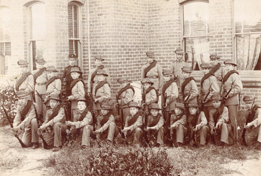
Photograph - Surrey College Cadet Corps, 1899, 1899
Surrey College was opened in early 1892 by Rev. Dr Frederick Darling who had been the first minister of the Presbyterian Church in Canterbury Road. He resigned this position to open the school which operated until 1908 with additional premises at 12 Vincent Street. The school had 40 boarders as well as day boys. Courses included algebra, euclid, history, typewriting, shorthand and drill. In the 1930s, Nethercourt Private Hospital took over the site. Later it became St Jude's Hospital. land in front of the building was subdivided off in the 1970s. The building is still extant as a private dwelling with York Street, Surrey Hills as the address. This is one of 3 photos donated by Susan Hobbs, whose grandfather Rev. George Edward Downton is thought to have been a student at the college. George E. Downton was born in Avoca in 1885. He was later a missionary in New Guinea and Secretary to the Australian Board of Missions in Adelaide. He died in 1926 or 1927. Sepia photo of 26 men and boys dressed in military uniform, many holding rifles. They are standing in front of a brick building with bay windows with blinds and curtains. There is a clump of foliage and grass in front of boys. "Surrey College - Surrey Hills / Principal: Rev Frdk. A. Darling, Melb. Univ./Cadet Corps, 1899." On the mount below the photo. Inscription on bottom right hand corner of photo: "Prepare for cavalry"schools, 1899, surrey hills, surrey college, rev frederick a darling, george edward downton, susan hobbs, union road, nethercourt hospital, st jude's hospital, 219-223 union road, cadet corps, 1890-1899 -
 Bendigo Historical Society Inc.
Postcard - BLANCHE SLY POSTCARD COLLECTION, 1900 - 1920
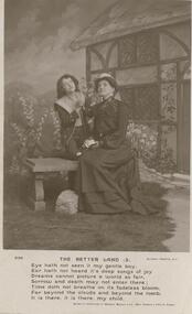
Postcard Album of Blanche Sly. Postcards stored in Folder 81 (49 postcards). 1403.1 - 1403.28 Grey linen look cover with picture of a small sailing boat pasted centre front pf cover. Partly torn sticker on lower LH corner. Blanche Victoria SLY Born: 11 Oct 1890, daughter of William and Hannah Sly Address: 1913; Loddon Vale Address: 1980; 100 Barnard Street Bendigo Died: Bendigo 12 June 1982, buried Bendigo G3 William Sly: Born: 1856 at Smythesdale, Victoria Married in Victoria in 1887; Hannah Theilman Died: Bendigo 1937, buried Bendigo G1 Hannah Sly Nee Theilman Born: 1866 Married in Victoria in 1887; William Sly Died: Bendigo 1948, buried Bendigo G3 See additional Research .Postcard Album of Blanche Sly containing 49 postcards. See 1403 B&W studio photo of two ladies sitting on a bench, looking skywards. Cottage and flowers as a backdrop. A poem 'The Better Land' beneath the photo.Addressee - Miss E Port (Staff), The Convalescent Home, Woolton. Nr Liverpool Sender - Florrie, The Vicarage Date stamp Jan 15, 1906postcard, collector, blanche sly -
 Bendigo Historical Society Inc.
Postcard - BLANCHE SLY POSTCARD COLLECTION, 1900 - 1920
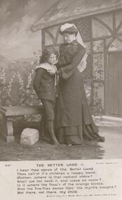
Postcard Album of Blanche Sly. Postcards stored in Folder 81 (49 postcards). 1403.1 - 1403.28 Grey linen look cover with picture of a small sailing boat pasted centre front pf cover. Partly torn sticker on lower LH corner. Blanche Victoria SLY Born: 11 Oct 1890, daughter of William and Hannah Sly Address: 1913; Loddon Vale Address: 1980; 100 Barnard Street Bendigo Died: Bendigo 12 June 1982, buried Bendigo G3 William Sly: Born: 1856 at Smythesdale, Victoria Married in Victoria in 1887; Hannah Theilman Died: Bendigo 1937, buried Bendigo G1 Hannah Sly Nee Theilman Born: 1866 Married in Victoria in 1887; William Sly Died: Bendigo 1948, buried Bendigo G3 See additional Research .Postcard Album of Blanche Sly containing 49 postcards. See 1403 B&W studio photo of a lady looking down at a youth Cottage and flowers as a backdrop. A poem 'The Better Land' beneath the photo.Addressee - Miss E Port (Staff), Convalescent Home, Woolton. Nr Liverpool Sender - Florrie Date stamp Jan 11, 1906postcard, collector, blanche sly -
 Falls Creek Historical Society
Magazine - Brigade Magazine Spring 2016
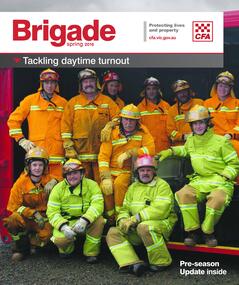
Brigade Magazine is issued to members of the Victorian CFA. The Spring edition of 2016 includes an article to acknowledge 21 years of service by the Falls Creek CFA. The article was written by Joy Nowakowski on behalf of the Falls Creek CFA with information provided by the Falls Creek Historical Society. Falls Creek Fire Brigade protects Falls Creek Village from fires throughout the year and supports other brigades to fight bushfires nearby and further away. In 2016 the brigade had 23 year-round volunteers. At a celebratory function at Falls Creek in June 2016, alpine pumper and brigade snowmobiles were on display. Falls Creek’s alpine pumper was the first of its kind in Australia. It had a pumping capacity of 4,000 litres a minute and its tracks enabled it to access areas of the village and ski fields. Until 2016 Falls Creek Village has been threatened by two major fires, the worst being in 2003 when CFA crews saved the village and the adjoining ski field infrastructure right at the boundaries. Snow making equipment was used to create a water/fog barrier that helped stop the fires from taking the village. The team that saved the village was considered heroic Support for fighting fires at Falls Creek dates back to 1956 but this support came from Mount Beauty, 30 kilometres down the mountain. Falls Creek locals were concerned by this, so used six available hydrants and a canvas hose to fight any fires on the mountain. In 1964 the SECV gave the village a trailer which could be used with both wheels and skis for summer and winter operations. But this trailer only lasted two years. In the early 1970s, the village was given a 2,000-gallon Ford Blitz 4WD truck, and additional equipment was quickly acquired by the village including a new locally-constructed trailer with a pumper unit. In the 1990s, a change in land status meant the Falls Creek area became the responsibility of CFA. This status was formalised in 1995 by a public meeting that formed Falls Creek Fire Brigade.This magazine is significant because it contains an article celebrating 21 years of Falls Creek CFA.A publication for CFA members which includes stories about recent incidents, brigades, training, events, community safety, health and safety and general CFA news. falls creek cfa, alpine firefighting, falls creek cfa 21 years -
 Flagstaff Hill Maritime Museum and Village
Book - Historical, Warrnambool, Richard Osburne, The History of Warrnambool, 1887
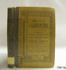
This little book is one of only 1000 books published of the original Queen's Jubilee Edition. It spans fifty years of the history of Warrnambool from the time that the first Government Land Sales commenced. It also deliberately coincides with the 1887 celebrations of Queen Victoria's Jubilee Year of her ascension to the British Throne. The book is an invaluable reference for researchers of local Warrnambool history and has been used as a text book and reference book for local students. The book had two owners before it became part of the Warrnambool Public Library, and when the library closed down, the book was held by the Warrnambool City Council until, in 1974, it was transferred to the newly established Flagstaff Hill Maritime Museum and Village. The author, Richard Osburne, (1825-1895) was born in Australia. He moved to Warrnambool in 1847 as the first local Journalist. In 1851 he founded the Warrnambool Examiner newspaper which he operated until the end of 1880. Osburne was much involved in civic and community affairs of the town, and he set himself the task of recording the history of the city's early pioneers. In the introductory pages of the book the author refers to himself as "The Father of the Warrnambool Press". Only 1,000 copies of this edition of the book were printed. In September 1980 a facsimile edition was printed with the addition of illustrations from the period, an index and relevant annotations by local historian T.A. Wicking (Tom Wicking). This later book was named the Premier Town Edition, due to Warrnambool being awarded the title of Premier Town in Victoria in 1979-82 by the Premier of Victoria; it also received the inaugural award in 1959 and a later award in 1988-91. This book is rare. It is one of only 1000 copies printed, and one of three in the Collection of Flagstaff Hill Maritime Museum and Village. The book was dedicated to the early colonists as well as to the new arrivals by the writer, Richard Osburne, who entitles himself as "The father of the Warrnambool Press". The content of the book is invaluable as a reference for Warrnambool and District's local history in its early colonial and pioneering days. It provides the information that helps in an understanding the foundation that the city was built on, connecting the people of today to the pioneers of the past. The inscriptions of two previous owners of the book, at least one of whom was a local resident, gives additional significance to this copy. The History of Warrnambool: Capital of the Western Ports of Victoria From1847 (when the first Government Land Sales took place) up to the end of 1886, By Richard Osburne, Proprietor of the Warrnambool Examiner from 1851 to the close of 1880. Author: Richard Osburne Publisher: Prahran: The Chronicle Printing & Publishing Company Limited Date: 1887 (MDCCCLXXXVII) Edition: Original: Queen's Jubilee Edition Small book with hard cover and reinforced spine. Dust jacket front has been pasted over front hard cover. The hardcovers are covered with clear adhesive plastic covering. Inscriptions include a typed label on the spine, a stamp at base of the fly page, on the loose page inside front cover, on inside back cover, and two hand written names on the second fly page; Jackson Giblett and G. M. Potter. The first fly page has a message to the readers, as shown in the Inscriptions of this record.Label on spine "R.A. 994.57 OSB" Inscriptions on second fly page: "Jackson Giblett / 1886" and "G.M. Potter, 70 Japan Street" Printed on fly page: "PRICE, FIVE SHILLINGS" Stamp of front end paper: WARRNAMBOOL / PUBLIC LIBRARY", "000336" and in a rectangular border " - - - - - - / WARRNAMBOOL / PUBLIC LIBRARY" First fly page: "THE QUEEN'S JUBILEE EDITION. TO OLD COLONISTS AND YOUNG AUSTRALIANS, OR NEW ARRIVALS, THIS HISTORY OF THE RISE AND PROGRESS OF THE CAPITAL OF WESTERN VICTORIA, IS DEDICATED AS INTERESTING AND USEFUL, BY "THE FATHER OF THE WARRNAMBOOL PRESS" RICHARD OSBURNE." Stamp inside back cover: "WARRNAMBOOL LIBRARY/ Liebig Street / Warrnambool 3280 / (055) 6- 2258"warrnambool, shipwreck coast, flagstaff hill, maritime museum, maritime village, the history of warrnambool, richard osburne, osturne's history of warrnambool, queen's jubilee edition, 1847-1887, warrnambool history, the chronicle printing and publishing company, capital of the western ports of victoria, first government land sales, warrnambool examiner, five shillings, warrnambool's first reporter, warrnambool public library, 1887, 1979, premier town, premier edition, queen's jubliee, queen victoria's jubilee, western ports of victoria, 1847, government land sales, chronicle publishing and printing co., g m potter, 1000 copies, t a wicking, jackson giblett, 1886, japan street, old colonists, young australians, new arrivals, rise and progress, capital of western victoria, interesting and useful, the father of the warrnambool press -
 University of Melbourne, Burnley Campus Archives
Plan - Photocopy, Sunshine Planning Scheme, 1993
Photocopies. 18.02.1993. (1) 5 copies Map User Guide - Sunshine Planning Scheme. List of Zones, Reservations and additional Planning Controls. (2) Sunshine Planning Scheme - Local Section. Zones and Reserved Land Map No 2. (3) Map No 3. (4) Map No 4. Used in planning Native Garden Woodlandsunshine, reservations, native garden, planning scheme, victoria department of planning and development -
University of Melbourne, Burnley Campus Archives
Plan, Keilor Planning Scheme, 1993
Photocopies. 18.02.1993. (1) 5 copies Map user guide - Keilor Planning Scheme, List of Zones Reservations and additional Planning Controls. (2) Keilor Planning Scheme - Local Section. Zones and Reserved Land Map No. 7. (3) Map No 9. Also 3 photocopies of maps joined together. Used in planning Native Garden Woodland Section.keilor, native garden, reservations, planning scheme, zoning, victoria department of planning and housing -
 Ringwood and District Historical Society
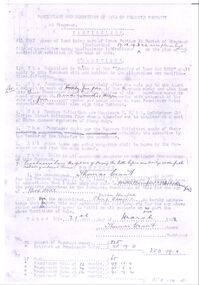
Document - Contract, Ringwood Property Sale from Thomas Grant to Walter and Philip Bamford 1908 (cnr Whitehorse Road and Warrandyte Road), 1908
The transfer of land in Ringwood from Thomas Grant to Walter and Philip Bamford on 21st March 1908.3 photocopied pages, poorly defined with some hand written details +Additional Keywords: Bamford, Walter / Bamford, Philip / Grant, Thomas -
 Ringwood and District Historical Society
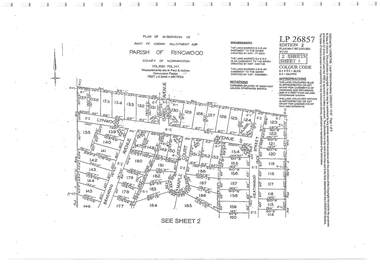
Document - Subdivision Plan, Part of Crown Allotment 32B Parish of Ringwood, County of Mornington Vol 6051 Fol 111 - LP26857
LANDATA Land Victoria 2-sheet plan printout dated 9/11/1953.Sheet 1 includes Lynwood Avenue, Isabel Avenue, Braewood Avenue, Maple Court, and Heathwood Street, Ringwood East, Vic. Sheet 2 includes Braewood Avenue, Rotherwood Avenue, and Heathwood Street, Ringwood East, Vic. Additional markings include LP46598, CP173330, LP86847, LP213448, LP217511, LP207217, LP56241. -
 Ringwood and District Historical Society
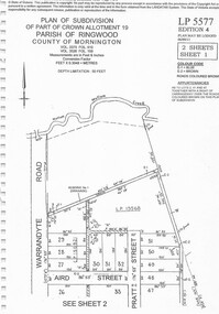
Document - Subdivision Plan, Part of Crown Allotment 19 Parish of Ringwood, County of Mornington Vol 3375 Fol 910 & Vol 3526 Fol 159 - LP5577
LANDATA Land Victoria 2-sheet plan printout dated 6/9/2011.Sheet 1 includes Warrandyte Road, Aird Street, and Pratt Street, Ringwood, Vic. Additional markings include LP19568 Sheet 2 includes Warrandyte Road, Aird Street, Pratt Street, and White Horse Road, Ringwood, Vic. Additional markings include SP25671H, CP100154, LP10519, LP28996 and P51182. -
 Ringwood and District Historical Society
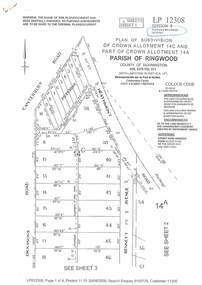
Document - Subdivision Plan, LP12308 Crown Allotment 14C and Part of Crown Allotment 14A Parish of Ringwood, County of Mornington Vol 5378 Fol 511 - Circa 1927
LANDATA Land Victoria 4-sheet plan printout dated 2009.Sheet 1 includes Canterbury Road, Heathmont Road, Dickasons Road and Bennett Avenue, Heathmont. Additional markings include PC353066. Sheet 2 includes Heathmont Road, Bennett Avenue and Orchid Street, Heathmont. Additional markings include PS326369 and SP24567. Sheet 3 includes Dickasons Road and Bennett Avenue, Heathmont. Additional markings include LP46776, SP28005 and PS335189. Sheet 4 includes Dickasons Road, Bennett Avenue and Orchid Street, Heathmont. Additional markings include SP25998, SP31080, SP31780, SP25968, SP25969 and LP46475. -
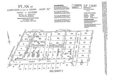 Ringwood and District Historical Society
Document - Subdivision Plan, LP11645 Part of Crown Allotment 26A, Parish of Ringwood, County of Mornington Vol 5164 Fol 1032616 - 1926
LANDATA Land Victoria 2-sheet plan printout dated 2009Sheet 1 includes Mount Dandenong Road, Valda Avenue and Velma Grove, Ringwood East. Additional markings include SP35514, SP22189, SP34206, SP35514, SP26794, PS319109, PS319010 and PS304868. Sheet 2 includes Mount Dandenong Road, Valda Avenue, Mirabel Avenue and Velma Grove, Ringwood East. Additional markings include SP26430, SP25320, PS341575, PS319110, PS319010, LP48415, SP22732, SP25844, PS304936 and PS304937. -
 Ringwood and District Historical Society
Document - Subdivision Plan, LP113220 Part of Crown Allotments 35 & 39B, Parish of Warrandyte, County of Mornington, Vol 6421 Fol 183 & 184 - 1965
LANDATA Land Victoria 2-sheet plan printout dated 2009Sheet 1 includes Kalinda Road, Ringwood. Additional markings include LP113117. Sheet 2 includes Kalinda Road and Maroondah Highway, Ringwood. Additional markings include LP86253. Both sheets include location of Drainage and Sewerage Reserve along Mullum Mullum Creek. -
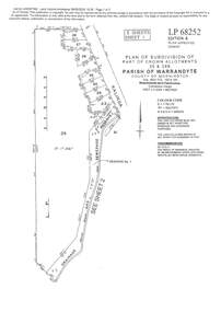
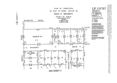 Ringwood and District Historical Society
Document - Subdivision Plan, LP135787 Part of Crown Section 23, Parish of Warrandyte, County of Evelyn, Vol 9293 Fol 947 and Vol 9503 Fol 640 - 1984
LANDATA Land Victoria 3-sheet plan printout dated 2007Sheet 1 includes Wonga Road, Mundara Drive, Gilston Way and Oakleaf Court, Ringwood. Additional markings include SP25252. Sheet 2 includes Wonga Road and Oakleaf Court, Ringwood. Sheet 3 includes Wonga Road, Wyndarra Court and Gem Close, Ringwood. -
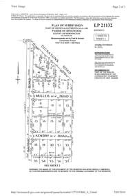 Ringwood and District Historical Society
Document - Subdivision Plan, LP21132 Part of Crown Allotment 14A & 14B, Parish of Ringwood, County of Mornington Vol 4929 Fol 657 - (Undated, circa 1920s/30)
LANDATA Land Victoria 2-sheet plan printout dated 2010.Sheet 1 includes Dickasons Road, Barnic Road, Muller Road and Kenbry Road, Heathmont. Sheet 2 includes Barnic Road and Possum Lane, Heathmont. Additional markings include LP83779. -
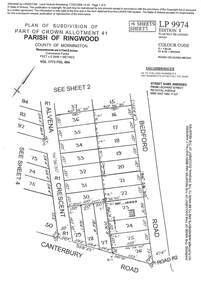 Ringwood and District Historical Society
Document - Subdivision Plan, LP9974 Part of Crown Allotment 41, Parish of Ringwood, County of Mornington Vol 1773 Fol 464 - 1924
LANDATA Land Victoria 4-sheet plan printout dated 2009Sheet 1 includes Alvena Crescent, Bedford Road and Canterbury Road, Heathmont. Additional markings include RP16869. Sheet 2 includes Alvena Crescent and Bedford Road, Heathmont. Additional markings include PS318390 and CP161633. Sheet 3 includes Bedford Road, Alvena Crescent and Royal Avenue, Heathmont. Additional markings include RP454. Street name amended from Leonard Street to Royal Avenue Vide Gaz 1962 P.427. Sheet 4 includes Alvena Crescent, Royal Avenue, Coleman Street and Canterbury Road, Heathmont. Additional markings include SP27861, PS305057, RP10566, SP34722 and LP116573. -
 Ringwood and District Historical Society
Document - Subdivision Map, Part of Crown Portion 22 Parish of Ringwood, County of Mornington. Vol 1915 Fol 827 - LP2427
LANDATA Land Victoria 4-sheet plan dated January 2003 - copy of original 1889 subdivision, amended with 1947 amendments by Assistant Registrar of Titles.Sheet 1 includes Main Lilydale Road (later Old Lilydale Road), Wandin Road (later Mount Dandenong Road), and Joseph Street, Ringwood East. Additional Plan markings SP30844, SP32804, LP144251, PS332061, PS305232. Sheet 2 includes Main Lilydale Road (later Old Lilydale Road), Wandin Road (later Mount Dandenong Road), and Dynes Street, Ringwood East. Additional Plan markings LP43708, LP44231, LP124702. Sheet 3 includes Main Lilydale Road (later Old Lilydale Road), Dynes Street, Albert Street (later Wyrunga Street), and Carcoola Road, Ringwood East. Additional Plan markings LP114181, LP114180, LP18261, LP214030, LP67300, PS354509, PS335500. Sheet 4 includes Main Lilydale Road (later Old Lilydale Road), Albert Street (later Wyrunga Street), and Carcoola Road, Ringwood East. Additional Plan markings PS315494, PS319495. -
 Ringwood and District Historical Society
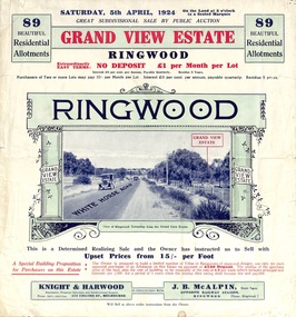
Flyer, Subdivisional Land Auction Sale Brochure, Grand Central Estate, Ringwood, Vic. - 1924
Refer also to Reg. No. 5148 for 1925 auction sale of land also titled Grand View Estate situated further south in Ringwood.Double sided multi-folded page advertising public auction sale on Saturday, 5th April, 1924, of residential allotments highlighting local facilities, services and layout of the estate. Includes panoramic view over the estate and other local photographic images. Additional clipped copy of subdivison map on blue cardboard backing includes real estate sales notations.Subdivision includes Whitehorse Road, Rupert Street, Herbert Street. and Leonard Street. Agents - Knight & Harwood, 315 Collins Street, Melbourne, Phone 10615, 10616 Central, in conjunction with J.B. McAlpin, Opposite Railway Station, Ringwood. Phone Ringwood 7. -
 Ringwood and District Historical Society
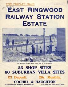
Flyer, Land Sale Brochure, East Ringwood Station Estate - c.1925
Multi-fold double sided sheet with yellow and blue print and blue monotone photographs advertising private sale of retail and residential sites. Brochure includes price list, and details of subdivision features and local facilities, with photographs. Additional clipped map of Estate on cardboard backing with handwritten sales notations and title ref LP11245.Subdivision includes Railway Avenue, Dublin Road, Lawrence Grove, Stanley Avenue. Agents - Coghill & Haughton, 79 Swanston Street, Melbourne, Phone Central 2793. Photographs include construction of East Ringwood Railway Station, "The Dive" where aquatic sports are held, Old East Ringwood Township, Davey's Hill. -
 Ringwood and District Historical Society
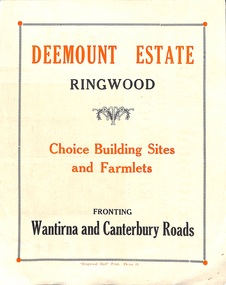
Flyer, Subdivisional Land Sale advertisement - Deemount Estate, Ringwood, Vic. - c.1950
Double sided folded page with black and orange advertisement and blueprint for Deemount Estate fronting Canterbury and Wantirna Roads, Ringwood, with handwritten price list and terms of sale. Additional undated hand-drawn map on light cardboard - 4 allotments on western side of Maidstone Street .Subdivision includes Canterbury Road, Wantirna Road and Maidstone Street. -
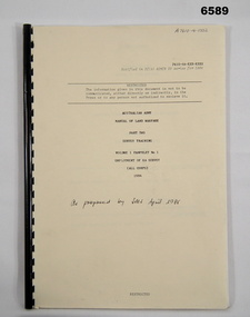 Bendigo Military Museum
Pamphlet - Manual of Land Warfare - Employment of RASvy - Survey Training, School of Military Survey, Bonegilla, Vic, 1984
This document is a draft proposal by the School of Military Survey (SMS) for the Manual of Land Warfare Volume 1, Phamphlet No1 - Employment of RASvy - Part 2, Survey Training 1984. The pamphlet describes the responsibilities and principles of employment of RASvy units and elements in the area of operations and in the support area. It outlines the roles, characteristics and tasks of RASvy units and elements, but no attempt has been made to detail staff or technical procedures. The document being a draft, contains many blank pages for additional information to be added prior to publication. RASvy was disbanded in 1996.45 x page A4 paper pamphlet containing text and diagrams. Buff coloured light card covers with a plastic comb binding.On the front cover: "A 7610 -14 - 1332" "As proposed by SMS April 1985"royal australian survey corps, rasvy, fortuna, army survey regiment, army svy regt, asr, school of military survey -
Surrey Hills Historical Society Collection
Photograph - Surrey College staff and boarders, 1899, 1899
Surrey College was opened in early 1892 by Rev. Dr Frederick Darling who had been the first minister of the Presbyterian Church in Canterbury Road. He resigned this position to open the school which operated until 1908 with additional premises at 12 Vincent Street. The school had 40 boarders as well as day boys. Courses included algebra, euclid, history, typewriting, shorthand and drill. In the 1930s, Nethercourt Private Hospital took over the site. Later it became St Jude's Hospital. land in front of the building was subdivided off in the 1970s. The building is still extant as a private dwelling with York Street, Surrey Hills as the address. This is one of 3 photos donated by Susan Hobbs, whose grandfather Rev. George Edward Downton is thought to have been a student at the college. George E. Downton was born in Avoca in 1885. He was later a missionary in New Guinea and Secretary to the Australian Board of Missions in Adelaide. He died in 1926 or 1927. Sepia photo of 26 men and boys and one female against a background of a two-storey brick building. This is the rear of the Surrey College. There are 4 additional figures in the background and an additional house can be seen beyond the property boundary. Many of the boys wear or hold caps or boaters. The 2 men in the back row on the right are wearing academic gowns and mortar boards. The gentleman with the beard on the end is Rev. Frederick Darling, the Principal of the college. Sepia photo on cream mount board. Note that the photo is detached from the mount, so the photo is numbered SHP2025.15.1 and the mount as SHP2025.15.2.Front: "Surrey College - Surrey Hills / Principal: Rev. Fredk. A. DARLING, Melb. Univ./STAFF AND BOARDERS, 1899." Back: "York Street, Surrey Hills" in grey lead pencil; possibly Susan John's hand. Back, bottom LH corner: "L. Johnstone" Back, top RH corner: "5621" - this was the registration number used by box Hill historical society Middle back: Purple stamp - "Tennent/Photographer / 110 Johnstone Street / Collingwood" schools, 1899, surrey hills, surrey college, rev frederick a darling, george edward downton, susan hobbs, union road, nethercourt hospital, st jude's hospital, 219-223 union road, 1890-1899, york street -
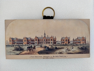 Royal Australian and New Zealand College of Obstetricians & Gynaecologists (RANZCOG)
Print - Colour print, Charles Webb, Original design of the Alfred Hospital, c. 1870
"The Alfred Hospital was founded in 1869 as a result of the work of a number of Melbourne doctors who fought a long and internecine battle for an additional general hospital treating its first patient in 1871. Prahran Council donated a parcel of low lying land for the provision of a Hospital. In 1870, the Melbourne architect, Charles Webb, won the competition to design The Alfred Hospital with his revolutionary design. Webb incorporated the "Nightingale" design principles by designing large light filled pavilions as wards connected by covered corridors or walkways." (Alfred Health)Small colour print mounted on a wood block. Print depicts a series of five red brick buildings at centre, with a dirt road snaking up from the left foreground to the front of the central building. A man is driving a two horse buggy along the dirt road towards the buildings. The landscape on either side of the road consists of grassland and low vegetation, as well as four shallow circular pits (two on either side) which contain vegetation. There are two figures in the right foreground cutting grass with scythes. A flock of birds is visible in the sky in the central background, above the main hospital building. Text printed below image reads 'THE ORIGINAL DESIGN OF THE ALFRED HOSPITAL/By C.Webb, Arckitect (sic)'. The back of the wooden block to which the print is affixes is painted black, and a circular hook has been attached to the centre back of the block for hanging the artwork. The hook is gold coloured, and attached using two gold coloured pins and a small strap. Handwriting at bottom right of the back of the object reads 'ANN TAVELL''THE ORIGINAL DESIGN OF THE ALFRED HOSPITAL/By C.Webb, Arckitect (sic)' -
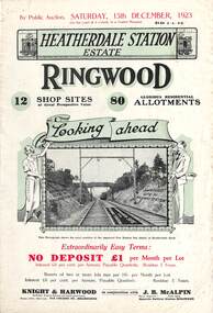 Ringwood and District Historical Society
Flyer, Subdivisional Land Auction Sale Brochures, Heatherdale Station Estate, Ringwood, Vic. - 1923 and 1924
Two double sided multi-folded pages advertising public auction sales of shop sites and residential allotments on Saturday, 15th December, 1923 and Saturday, 2nd February, 1924, including summary of local facilities, services and map showing layout of the estate. Includes a photograph depicting proposed site for first Heatherdale railway station and a panoramic view of Ringwood from the railway level crossing in Heatherdale Road. 1923 and 1924 flyers are identical except for the auction dates printed at the top.Subdivision includes Heatherdale Road, Molan Street, Yallourn Parade, Newman Street, and Madden Street. Agents - Knight & Harwood, 315 Collins Street, Melbourne, Phone 10615, 10616 Central, in conjunction with J.B. McAlpin, Opposite Railway Station, Ringwood. Phone Ringwood 7. Additional cardboard-backed copy of map includes later penciled sales notations for some blocks (VC 5801 refers). -
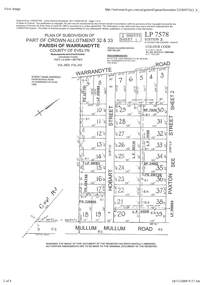 Ringwood and District Historical Society
Document - Subdivision Plan, Part of Crown Allotment 32 & 33 Parish of Warrandyte, County of Evelyn Vol 3922 Fol 242
LANDATA Land Victoria 2-sheet plan printout dated 16/6/1919.Sheet 1 includes Warrandyte Road, Hobart Street, Paxton Street, and Mullum Mullum Road, Ringwood, Vic. Additional markings include PS327701, LP215189, RP7936, LP110103, LP36735, LP31149, SP24012, PS310739, PS326740, PS336885, LP41558. Sheet 2 includes Warrandyte Road, Paxton Street, Arnold Street, and Mullum Mullum Road, Ringwood, Vic. Additional markings include RO270, SP26622, LP50242, RP19467, SP27005, SP31440, PS312181.