Showing 810 items matching "aerial views"
-
 Eltham District Historical Society Inc
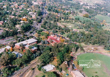
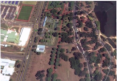
Photograph, Aerial view of Eltham Shire Office and Eltham Library precinct, 1994, 1994
... Aerial view of Eltham Shire Office and Eltham Library...Colour photograph of oblique aerial view centred on Eltham... photograph of oblique aerial view centred on Eltham Library, 1994 ...Colour photograph of oblique aerial view centred on Eltham Library, 1994eltham, eltham library, eltham shire offices, eltham central park, alistair knox park, main road, aerial photographs -
 Federation University Historical Collection
Booklet, Wendy Morris, A Guide to Maldon, 1983, 1983
... Soft covered booklet featuring an aerial view of the town... featuring an aerial view of the town of Maldon on the cover. A Guide ...Soft covered booklet featuring an aerial view of the town of Maldon on the cover. heritage, tourism, maldon, mining, streetscape, townscape, gardens, quartz reef mining, geology, maldon goldmines, maldon hospital, kangaroo hotel, architecture, conservation and planning, cast iron, forests, mount tarrangower, nuggetty ranges, beehive -
 Glenelg Shire Council Cultural Collection
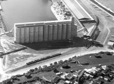
Photograph - Photograph - ariel view of grain silo construction, Portland, 1970
... construction, aerial view.... and white photograph of grain silos under construction, aerial view ...Port of Portland Authority archivesFront: (no inscriptions) Back: (no inscriptions)port of portland archives, grain silos, aerial photography -
Port Melbourne Historical & Preservation Society
Photograph - Aerial view of Port Melbourne, 1978
... Aerial view of Port Melbourne...Two A3 photocopies of aerial view of Port Melbourne c 1978... photocopies of aerial view of Port Melbourne c 1978 Photograph Aerial ...Two A3 photocopies of aerial view of Port Melbourne c 1978local government - city of port melbourne, phillip donnellon -
 Hume City Civic Collection
Photograph, Late 1980s
... A black and white aerial view of one of the Aboriginal ring... aboriginal rings george evans collection A black and white aerial ...A study was conducted to locate a number of Aboriginal sites in Sunbury in the 1980s. This study took place as a result of the expanding development on Sunbury's outskirts.A black and white aerial view of one of the Aboriginal ring sites in Sunburyaboriginal sites, aboriginal rings, george evans collection -
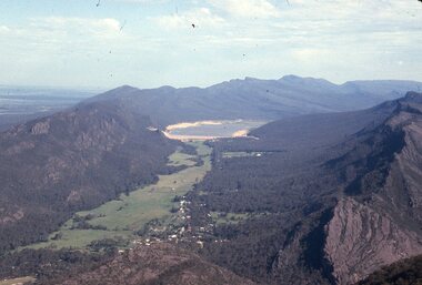
 Stawell Historical Society Inc
Slide, Ian McCann, Aerial View Grampians & Construction of Bellfield, 1960's
... Aerial View Grampians & Construction of Bellfield...Colour Slide; aerial View of Mt William through scattered... grampians Grampians Mt William Colour Slide; aerial View of Mt ...Colour Slide; aerial View of Mt William through scattered cloudsgrampians, mt william -
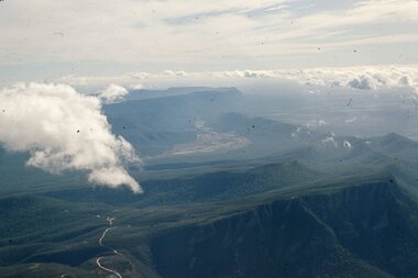 Stawell Historical Society Inc
Slide, Ian McCann, Aerial View of Grampians Ranges inc Valley, 1960's
... Aerial View of Grampians Ranges inc Valley...Colour Slide: Aerial View of Grampians Showing both Ranges... grampians Grampians Colour Slide: Aerial View of Grampians Showing ...Colour Slide: Aerial View of Grampians Showing both Ranges and the Valley grampians -
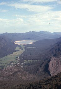 Stawell Historical Society Inc
Slide, Ian McCann, Aerial View of Lake Bellfield, 1960's
... Aerial View of Lake Bellfield...Colour Slide: Aerial View of Lake Bellfield Looking Up... grampians Grampians Lake Bellfield Colour Slide: Aerial View of Lake ...Colour Slide: Aerial View of Lake Bellfield Looking Up the Valleygrampians, lake bellfield -
 Whitehorse Historical Society Inc.
Photograph, Aerial View of Site for Nunawading Civic Centre, 12/06/1968 12:00:00 AM
... Aerial View of Site for Nunawading Civic Centre....Black and white photo of Aerial View of Site for Nunawading... of Aerial View of Site for Nunawading Civic Centre. Aerial View ...Black and white photo of Aerial View of Site for Nunawading Civic Centre.nunawading civic centre -
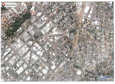 Bendigo Historical Society Inc.
Map - BENDIGO MAP AERIAL VIEW
... BENDIGO MAP AERIAL VIEW...Map of Bendigo. Aerial View of Bendigo. Published by City... PHOTOGRAPH Aerial bendigo Map of Bendigo. Aerial View of Bendigo ...Map of Bendigo. Aerial View of Bendigo. Published by City of Bendigo. Undated.photograph, aerial, bendigo -
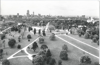 Melbourne Legacy
Photograph, Shrine of Remembrance, 1973
... Black and white photo of an aerial view of the Shrine... Black and white photo of an aerial view of the Shrine ...A photo of the Shrine, it shows the Melbourne skyline and the gardens from an elevated position. It was used on the cover of the programme for the annual "Anzac Commemoration Ceremony for Students" in 1973. It was used for several years afterwards as well. The student events were usually held just prior to ANZAC Day.The Shrine is an imposing building in the Melbourne skyline. Images like this were used by Legacy on the cover of their school students' Anzac service programmes.Black and white photo of an aerial view of the Shrine of Remembrance and a strip of negatives.shrine of remembrance, garden -
 Stawell Historical Society Inc
Slide, Ian McCann, Aerial View of Lake Belfield in the distance, 1960's
... Aerial View of Lake Belfield in the distance...Colour Slide: Aerial View of Grampians Valley with lake...Grampians Lake Bellfield Colour Slide: Aerial View ...Colour Slide: Aerial View of Grampians Valley with lake Bellfield in the distancegrampians, lake bellfield -
Lakes Entrance Historical Society
Photograph - Framed photograph, 2002c
... Mounted photograph, aerial view of waterway and housing..., aerial view of waterway and housing area from Kalimna Photograph ...Mounted on chipboard, rear of backboard has strap for wall hangingMounted photograph, aerial view of waterway and housing area from Kalimnaphotography, photographs, slides, film -
 Ballarat Tramway Museum
Photograph - Colour Print, Google Earth, Jan. 2015
... Aerial views... Junction Aerial views Solar Panels Gardens Fish Hatchery Laminated ...Yields information about the South Gardens Reserve and the BTM, including Depot Junction following its redevelopment late 2014.Laminated colour photograph of the South Gardens Reserve Precinct, showing the revised depot junction - completed late Dec. 2014, the fish hatchery, the tram depot with Solar panels, Nov. 2014. Image downloaded from Google Earth 31/3/2015. Has a single trucker on 2 road and 939 on 3 road. See images i2 and i3 for other digital photos prepared from Google Earth at the same time. Image i2 has the solar panels marked by a red arrow.trams, tramways, btm, depot junction, aerial views, solar panels, gardens, fish hatchery -
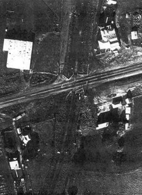 Ballarat Tramway Museum
Document - Photocopies, John Phillips, Bungaree Aerial photo, 1980's
... Aerial views... at Seymour St loop. Trams tramways Bungaree Aerial views Victorian ...Demonstrates the use of bogie trams on the Lydiard St North route and the crossing of trams at Seymour St loop.Two sets of three copies of the Victorian Railways aerial photographs of Bungaree Railway station late 1960's early 1970's. Shows tennis court, station buildings, houses and sheds in the station yard. The level crossing does not appear to have any flashing lights installed on it.trams, tramways, bungaree, aerial views, victorian railways -
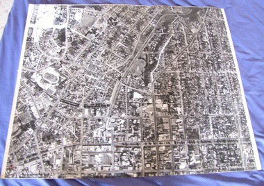 Ballarat Tramway Museum
Photograph - Black & White Photograph/s, late 1960's
... Aerial views... Aerial views Sovereign Hill On rear in pencil "2384/90" Black ...Black and white aerial photograph of the central area of Ballarat ranging from Mair St to Mt Pleasant, Drummond St and Victoria St. Taken late 1960's as it would appear that the construction of Sovereign Hill has commenced. Shows the tram tracks and possibly parking areas being marked out. On rear in pencil "2384/90"trams, tramways, ballarat, aerial views, sovereign hill -
 Ballarat Tramway Museum
Photograph - Illustration/s, News and Information Bureau - Photo, Ballarat view from Town Hall, Oct. 1958
... Aerial views.... Trams tramways Sturt St Black Hill Aerial views Trackwork ...Yields information about the Sturt and Lydiard St streetscape from the Town Hall, c1958.Photograph of intersection of Sturt St and Lydiard St from Town Hall. Looking north east to Black Hill. See also item with Reg. No. 667 of similar but earlier view. Photo is inside cover of ANZ quarterly survey, dated Oct. 1958. Shows four trams in City Loop and good photo of trackwork and motor cars of period. Not to be displayed - before copy neg made.Ballarat - important Provincial Citytrams, tramways, sturt st, black hill, aerial views, trackwork -
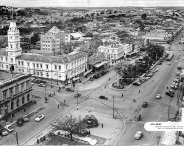
 Ballarat Tramway Museum
Photograph - Illustration/s, Herald & Weekly Times Ltd, Sturt St. Aerial View, 1934, Jan. 1934
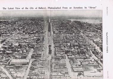
... Sturt St. Aerial View, 1934... aerial views... in an aerial view dated 1934. Shows buildings such as the Gas Works ...Yields information about Ballarat from the eastern aspect of the city looking west in an aerial view dated 1934. Shows buildings such as the Gas Works and other buildings that no longer exist.Photographic reproduction of Ballarat looking west down Sturt St., page 6 of Magazine section of Weekly Times, Jan 20, 1934. On rear is two colour photo of Alexandria Avenue, Melbourne. Record updated and image added 21/9/2013.trams, tramways, ballarat, sturt st., aerial views -
 Bacchus Marsh & District Historical Society
Photograph, Aerial image of Bacchus Marsh and Darley in 1994
... Aerial Views Bacchus Marsh Vic..... Arbee Real Estate Agency Bacchus Marsh Aerial Views Bacchus ...A whole of town and nearby area aerial image of Bacchus Marsh produced for display in the Arbee Real Estate Agency premises in Main Street, Bacchus Marsh.A large framed colour aerial photograph showing the township of Bacchus Marsh, the neighbouring smaller community of Darley, and the nearby areas of both places. "Bacchus Marsh - Darley. Aerial Photo 27 November, 1994. Presented by Arbee Real Estate "Professionals"'arbee real estate agency bacchus marsh, aerial views bacchus marsh vic. -
 Melbourne Tram Museum
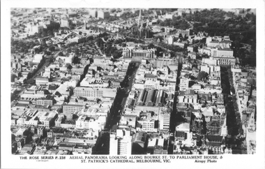
Postcard, Rose Stereograph Co, "Aerial Panorama looking along Bourke St.", mid 1940s
... aerial views.... aerial views Melbourne Bourke St Collins St Eastern Market ...Rose Series postcard No. P 238, titled "Aerial Panorama looking along Bourke St. to Parliament House & St Patrick's Cathedral, Melbourne - Airspy photo" - There are buses in Bourke Street. Note the three large roof spans of the Eastern Market in the middle of the photo. Photo dated around mid-1940s.Yields information about east end of both Bourke and Collins Streets in the mid 1940s.Postcard - printed real photograph with Rose Stereograph Co. name on the rear.aerial views, melbourne, bourke st, collins st, eastern market -
 Melbourne Tram Museum
Postcard, Rose Stereograph Co, "Melbourne from the Air", early 1940s
... aerial views... information about an aerial view of Melbourne C1930 tramways trams ...Rose Series postcard No. P 622, titled ""Melbourne from the Air", Photo looking east over Melbourne with the Melbourne skyline, railway yards, St Kilda Road, Yarra River and Princes Bridge in the view. Three trams can be seen in the view in St Kilda Road. The building in the middle bottom of the photo is the recently completed Australian Provincial Assurance (APA) Assocation Limited Head Office on the south east corner of Collins and Queen Streets. This 1889 building was refaced and the tower added in 1928-1929. The adding of three additional floors to the Bank of Australasia building, 1875-1876, is well in hand 1929-1931 on the north west corner of Queen and Collins Streets. On the south east corner of the corner of Collins and Market Streets, the new Australian Mutual Provident (AMP) Society Head Office is reaching full height, also constructed 1929-1931. Yields information about an aerial view of Melbourne C1930Postcard - printed real photograph with Rose Stereograph Co. name on the rear.tramways, trams, aerial views, melbourne, collins st. -
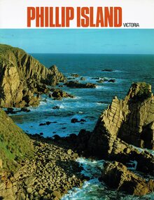 Phillip Island and District Historical Society Inc.
Booklet, Phillip Island Victoria, 1978
... aerial views... aerial views Alice Robinson Glossy coloured booklet containing ...Tourist information on Phillip Island attractions from the 1970sHistoricalGlossy coloured booklet containing large coloured photos of buildings, animals and tourist attractions. phillip island, tourist brochure, hotels, cowes, aerial views, alice robinson -
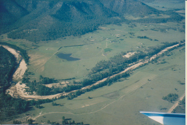 University of Melbourne, Burnley Campus Archives
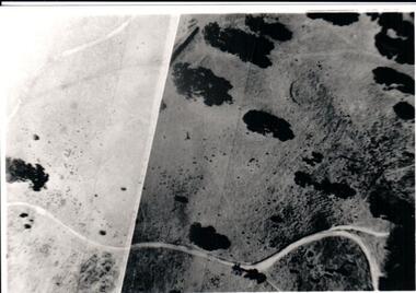
Photograph - Colour print, Aerial View of Countryside, Unknown
... Aerial View of Countryside...aerial views...countryside aerial views river valley farm buildings dams ...4 colour photographs taken from a small aeroplane. Views of countryside, river, valley, mountains, dams, farm buildings countryside, aerial views, river, valley, farm buildings, dams, mountains -
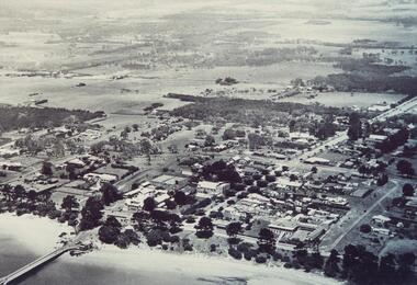 Phillip Island and District Historical Society Inc.
Photograph, 1940's 1950's
... aerial view of cowes...Black & White aerial view of the Cowes Township and jetty... cowes phillip island aerial view of cowes cowes jetty cowes pier ...Photograph donated by John JanssonBlack & White aerial view of the Cowes Township and jetty area, Phillip Islandcowes phillip island, aerial view of cowes, cowes jetty, cowes pier phillip island, john jansson -
Glenelg Shire Council Cultural Collection
Postcard - Postcard - Portland Harbour, n.d
... Coloured postcard, aerial view of Portland Harbour, town... Back: Maker's details Coloured postcard, aerial view ...Coloured postcard, aerial view of Portland Harbour, town and Fawthrop Lagoon in backgroundBack: Maker's detailspostcard, tourism, travel -
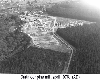 Glenelg Shire Council Cultural Collection
Photograph, Dartmoor Pine Mills, Apr-76
... Aerial view of pine plantation and a mill. Houses...) (pen). Aerial view of pine plantation and a mill. Houses ...Port of Portland Authority archives.Front: (no inscriptions) Back: Portland Harbour Trust Commissioners (purple stamp) (centre). Dartmoor Pine Mills (lower left) (pencil) April, 1976 (lower left) (pen).port of portland -
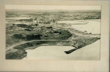 Glenelg Shire Council Cultural Collection
Photograph, (untitled), 1954
... BxW photograph. Aerial view of develpoment of Port...: (no inscriptions) Back: 1954 BxW photograph. Aerial view of develpoment ...Port of Portland Authority archives.Front: (no inscriptions) Back: 1954port of portland archives -
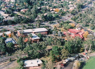 Eltham District Historical Society Inc
Photograph, Aerial view of Eltham Shire Office and Eltham Library precinct, 1994, 1994
... Aerial view of Eltham Shire Office and Eltham Library...Colour photograph of oblique aerial view centred on Eltham... photograph Colour photograph of oblique aerial view centred on Eltham ...Colour photograph of oblique aerial view centred on Eltham Shire Offices, 1994eltham shire office, eltham library, main road, eltham, aerial photograph -
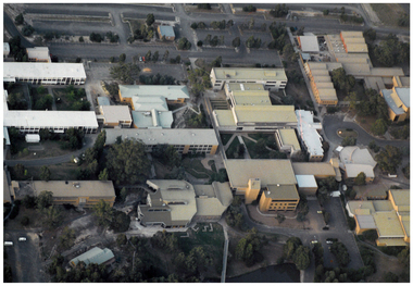 Federation University Historical Collection
Photograph - Photograph - Colour, Aerial Photograph of Federation University Mount Helen Campus
... Colour photograph showing an aerial view of the Federation... university Colour photograph showing an aerial view of the Federation ...Federation University Australia was established on 1 January 2014. Formerly known as the University of Ballarat, its enabling legislation was the University of Ballarat Amendment (Federation University Australia) Act 2013. Although formally created as a University in 1994, the University of Ballarat has a lineage back to 1870 with the establishment of the School of Mines Ballarat, making it the third institution of higher learning to be established in Australia and the first to be established in regional Australia. On 1 January 1994, Ballarat University College became the University of Ballarat and in 1998 the University merged with three TAFE Institutes to become a dual sector institution with multiple campuses. On 1 January 2014, the University of Ballarat amalgamated with the Monash University Gippsland Campus to form Federation University Australia. The Gippsland Campus also had a long lineage dating back to 1928 with the establishment of the Yallourn Technical School which became a predecessor institution to the Gippsland College of Advanced Education formed in 1968. In 1990, it was renamed the Monash University College and in 1993 became the Gippsland Campus of Monash University. In 2016, Federation University Australia announced plans to take possession, over a two-year period, of Monash’s Berwick Campus in the south-east corridor of Melbourne. Federation University Australia, or FedUni, is headquartered in Ballarat and offers programs in Higher Education and Vocational Education and Training to regional Victoria and beyond. The University’s commitment to educational and social equity, teaching excellence, research distinction, environmental sustainability and regional capacity building has enabled it to develop in a way that draws on its proud heritage to inform its future. Its regional character sets a framework for the University’s priorities but does not constrain it from serving wider community interests, nationally and internationally. The name Federation University Australia was chosen to convey the scope and capacity of an expanded regional university with a federated network of campuses.Colour photograph showing an aerial view of the Federation University Mount Helen Campus.aerial, mount helen campus, federation university -
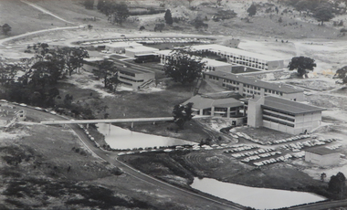 Federation University Historical Collection
Photograph - Photograph - Black and White, Ballarat College of Advanced Education, Aerial view of the Mt Helen campus from the north, c1975
... Ballarat College of Advanced Education, Aerial view of the...black and white photograph: Aerial view of Mt Helen campus... photograph: Aerial view of Mt Helen campus from the north Ballarat ...black and white photograph: Aerial view of Mt Helen campus from the north mount helen campus, mount helen campus aerial, student residences, p building, f building, g building, l building, mt helen library, union building, u building, e.j. barker library, aerial