Showing 1400 items
matching allotments
-
 Bendigo Historical Society Inc.
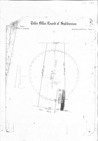
Document - LANDS OFFICE: SANDHURST LISTS OF ALLOTMENTS SOLD 1854 - 1856, 1854 - 1856
Document: LANDS OFFICE: SANDHURST LISTS OF ALLOTMENTS SOLD 1854 - 1856 Sandhurst lists of allotments sold, dated 1854 - 1856. Sandhurst land sales outlying districts 1854 -1861. Loose pages in plastic pockets, blue lined, formerly in register that has degraded and not repairable. Lists of date of sale, no. of lot, parish, allotment, section, extent (size) purchasers name.Lands Officeland sales 1854, lands office, sandhurst, bendigo -
 City of Moorabbin Historical Society (Operating the Box Cottage Museum)
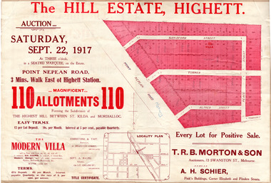
Flyer - The Hill Estate, Highett, 1917
The land sales in the area stopped due to the 1890s depression. For the next 20 years real estate sales virtually stopped until after WWI.Example of the progress of the Municipality of MoorabbinAdvertising flyer for auction of real estate sales - plan of building blocks for saleThe Hill Estate, Highett - 110 allotments - Auction Saturday September 22, 1917 T.R.B. Morton & Sonpoint nepean road (nepean highway), turner street, sanford street, alfred street, peace street, highett, real estate, moorabbin -
 Ringwood and District Historical Society
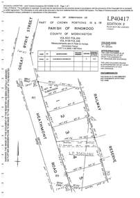
Document - Subdivision Plan, LP40417 Part of Crown Portions 16 & 18, Parish of Ringwood, County of Mornington, Vol 6231 Fol 035 and Vol 8139 Fol 248 - 1957
LANDATA Land Victoria plan printout dated 2008Map includes Heathmont Road, Heathmont, with allotments adjoining Railway Reserve. Other markings include LP95632NS. -
 Whitehorse Historical Society Inc.
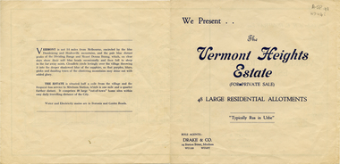
Document, Vermont Heights Estate
Sale brochure for 'Vermont Heights Estate', Vermont,Sale brochure for 'Vermont Heights Estate', Vermont, 48 allotments. Agent: Drake & Co.Sale brochure for 'Vermont Heights Estate', Vermont,land sales, vermont heights estate, centre road, vermont, penllyne avenue -
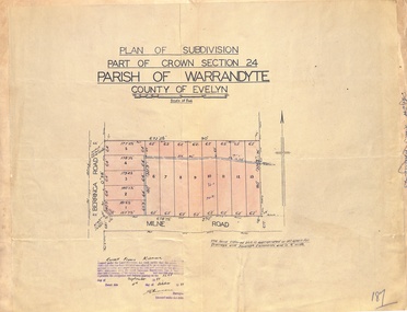 Ringwood and District Historical Society
Map - Plan of Subdivision, Part of Crown Section 24, Parish of Warrandyte, County of Evelyn - 1951
Survey map of residential allotments in Berringa Road and Milne Road, Park Orchards, Victoria. Russell Francis Kinnane, Licensed Surveyor, 4th October, 1951. -
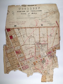 Bendigo Historical Society Inc.
Map - TOOLLEEN ALLOTMENTS, circa 1870
Map: Parish plan showing Village allotments at Toolleen, Parish of Toolleen, County of Rodneymap, rodney, toolleen, parish of toolleen, county of rodney -
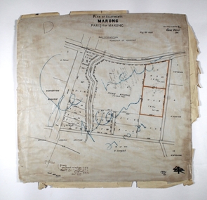 Bendigo Historical Society Inc.
Map - MARONG ALLOTMENTS, 25/08/1906
Map: Plan of Allotments at Marong, Parish of Marong, County of Bendigo. Hand draughted mapmap, bendigo, parish plan, marong, parish of marong -
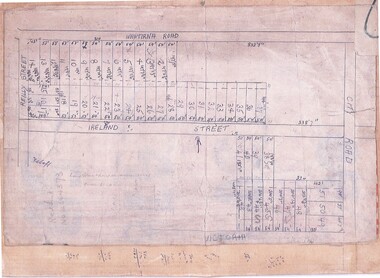 Ringwood and District Historical Society
Document, Subdivision Map (Undated) - Ringwood, Victoria
Hand-drawn copy of subdivision plan showing numbered residential allotments with property dimensions.Map includes Wantirna Road, Ireland Street, City Road and Victoria Street (later Regina Street), Ringwood, Victoria. -
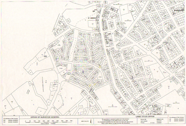 Bendigo Historical Society Inc.
Map - LONG GULLY HISTORY GROUP COLLECTION: LONG GULLY AREA
Copy of a map showing streets and allotments in the Long Gully area, last updated 30/05/97, printed 19/06/97. Made by the Land Titles Office. Some street names, reserves and allotment numbers are printed on the map.bendigo, history, long gully history group, the long gully history group - long gully area, land titles office, office of surveyor general, city of bendigo, shire of marong, state electricity commission -
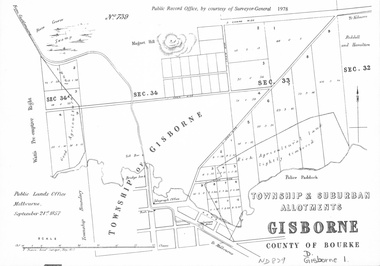 Whitehorse Historical Society Inc.
document - Map, Melbourne Metro, 1978
Collection of reproductions issued by the Public Record Office in 1978. Comprises: Allotments in the Black Forest, 1857; Township of Dandenong, 1856; Township and suburban allotments, Gisborne, 1857; Storing Yard allotments near the Melbourne Wharf, 1854; Town lots near the Railway Terminus, Melbourne, 1863; Parish of Prahran, 1853; Township of Sandridge, 1855; Township of Sunbury, 1857; River Yarra Yarra at the Queens Wharf, 1860.victoria. public record office, black forest, victoria, dandenong, gisborne, melbourne wharf, railway terminus, spencer street, melbourne, prahran, sandridge, sunbury, queens wharf -
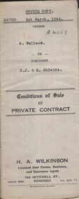 Bendigo Historical Society Inc.
Document - H.A. & S.R. WILKINSON COLLECTION: CONTRACT OF SALE
Conditions of sale by private contract dated 1st March, 1944 between A. Wallace (seller) and R.J. & E. Shields (buyer) for land situate in Ellis Street, Kennington containing six acres being described in certificate of title volume 4983 folio 995671 section H and being Crown allotments 529,529A, 529B. Crown grant volume 6111 folio 1222194, crown allotments 530, 530A section H. Crown grant volume 6307 folio 1261328, Crown allotment 529F section H. Crown grant volume 6307 folio 1261329, Crown allotment 529C section H. Crown grant volume 6307 folio 1261293, crown allotment 529D section H. Crown grant volume 6307 folio 1261294 crown allotment 529E section H. Together with 6-roomed weatherboard dwelling and all sundry. Price 1,300 pounds.organization, business, h.a. & s.r wilkinson real estate -
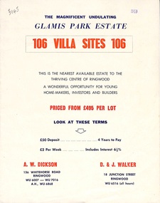 Ringwood and District Historical Society
Flyer, Land Sale Brochure, Glamis Park Estate (Wantirna, Vic.) - 1959
Street name Carnarvon Avenue on the subdivision plan became Selkirk Avenue at some stage during or subsequent to development of the Estate.Bi-folded advertisement for sale of residential allotments, including summary of subdivision features and local facilities.Subdivision includes Wantirna streets - Wantirna Road, Carnarvon Avenue, Inchcape Avenue, St Thomas Avenue, St Davids Drive, Dudley Avenue, Angus Avenue. Agents - A.W. Dickson, 136 Whitehorse Road, Ringwood, Telephone WU 6007, WU 7016, A.H. WU 6868. D. & J. Walker, 18 Junction Street, Ringwood, Telephone WU 6516 (all hours). -
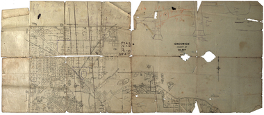 Federation University Historical Collection
Plan, Creswick, County of Talbot
This plan is associated with former Ballarat School of Mines Student Richard Squire (1875-1876). Gift of the Squire Family, 2014 Plan showing allotments in Creswick, County of Talbot. The plan is in a number of pieces with some sections missing.creswick, creswick creek, spring hill, sarah paterson, lehman, mullins, spittle, squire, richard squire -
 Bendigo Historical Society Inc.
Map - JACK FLYNN COLLECTION: ARCHDALE, 15/01/1936
Map: Parish of Archdale, County of Gladstone. Parish plan. The Allotments have been coloured in with pencil.By Authority H.J. Green, Government Printer Melbourne. Drawn and Reproduced at the Dept, of Lands and Survey, Melbourne, Victoria. 15/01/36map, gladstone, parish plan, archdale , gladstone -
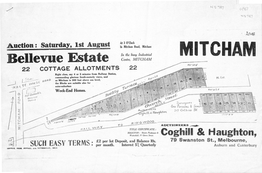 Whitehorse Historical Society Inc.
Pamphlet, Bellevue Estate, ca 1927
Land sale of 22 allotments at Mitcham ca 1927 bounded by Barkly Terrace and Church Street.land sales, barkly terrace, mitcham, church street, bellevue estate, coghill & haughton -
 Ringwood and District Historical Society
Map - Plan of Subdivision, Part of Crown Section 24, Parish of Warrandyte, County of Evelyn - undated, circa 1951
Survey map of residential allotments in Milne Road, east of Berringa Road, Park Orchards, Victoria. -
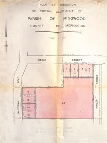 Ringwood and District Historical Society
Document, Plan of Subdivision - Part of Crown Allotment 10A, Parish of Ringwood, County of Mornington - 1957
Map of residential allotments in Wantirna Road and Reilly Street, Ringwood, and Philip Street, Heathmont, Vic.Footnote includes "Lots numbered 5 to 11 and 16 to 23 both inclusive are not included in this plan. Signature of Consulting Engineer - Alan J. Brown BCE, LS, MVIS, Licensed Surveyor, Dillons Buildings, 1 Riversdale Road, Camberwell (Phone) WF3528 dated 1-4-1957. -
 Kew Historical Society Inc
Plan - Subdivision Plan, High Street, Kew, 1920-1935
Pru Sanderson, in her groundbreaking ‘City of Kew Urban Conservation Study : Volume 2 - Development History’ (1988), summarised the periods of urban development and subdivisions of land in Kew. The periods that she identified included 1845-1880, 1880-1893, 1893-1921, 1921-1933, 1933-1943, and Post-War Development. These periods were selected as they represented periods of rapid growth or decline in urban development. An obvious starting point for Sanderson’s groupings involved population growth and the associated economic cycles. These cycles also highlighted urban expansion onto land that was predominantly rural, although in other cases it represented the decline and breakup of large estates. A number of the plans in the Kew Historical Society’s collection can also be found in other collections, such as those of the State Library of Victoria and the Boroondara Library Service. A number are however unique to the collection.The Kew Historical Society collection includes almost 100 subdivision plans pertaining to suburbs of the City of Melbourne. Most of these are of Kew, Kew East or Studley Park, although a smaller number are plans of Camberwell, Deepdene, Balwyn and Hawthorn. It is believed that the majority of the plans were gifted to the Society by persons connected with the real estate firm - J. R. Mathers and McMillan, 136 Cotham Road, Kew. The Plans in the collection are rarely in pristine form, being working plans on which the agent would write notes and record lots sold and the prices of these. The subdivision plans are historically significant examples of the growth of urban Melbourne from the beginning of the 20th Century up until the 1980s. A number of the plans are double-sided and often include a photograph on the reverse. A number of the latter are by noted photographers such as J.E. Barnes.A roughly drawn and faded actual or projected subdivision of a parcel of land bordering on High and Mary Streets. The plan shows five allotments facing High Street and at their rear, another allotment facing Mary Street. In 1906, when the Board of Works surveyors completed Detail Plan 1589, the allotment in Mary Street is shown to include a building. The section of land attached to this building is shown to be undeveloped, thus making a further subdivision possible.subdivision plans - kew, high street -- kew (vic.), mary street -- kew (vic.) -
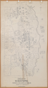 Federation University Historical Collection
Plan, Borough of Sebastopol, 1940, 01/07/1940
Sebastopol became a suburb of the City of Ballarat.Plan showing the streets, allotments creeks in the Borough of Sebastopol, Parishes of Ballaarat and Cardigan, County of Grenville, in 1940. sebastopol, t. rider, yarrowee creek, leigh river, st george's reserve, leigh creek, sebastopol public gardens, sebastopol recreation reserve, gravel reserve, night soil depot, sanitary depot, rubbish depot -
 Whitehorse Historical Society Inc.
Document, Crown Allotment
Land documents relating to Crown Allotment 116 Shady Grove Nunawading Parish of Nunawading County of BourkeLand documents relating to Crown Allotment 116 Shady Grove Nunawading Parish of Nunawading County of BourkeLand documents relating to Crown Allotment 116 Shady Grove Nunawading Parish of Nunawading County of Bourkeland titles, holmes, dave, shady grove nunawading no.76, helen, jobbins, thomas, the freehold investment and banking company of australia ltd, wilson, david duncan butchart, boyle, walter, holbery, emily rachel, fisher, james cowley morgan -
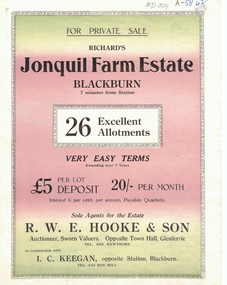 Whitehorse Historical Society Inc.
Document, Jonquil Farm Estate
Brochure of Richard's Jonquil Farm EstateBrochure of Richard's Jonquil Farm Estate featuring 26 allotments, 7 minutes from Blackburn Station.Brochure of Richard's Jonquil Farm Estate land subdivision, jonquil farm estate blackburn, laurel grove, blackburn, boongarry avenue, main street, linum street, hooke, r.w.e. & son, keegan, i.c. -
 Beechworth Honey Archive
Hand-Drawn Diagram of Land by Frank Lebbell Frost September 1920
Hand-drawn diagram of land at Dookie by Frank L. Frost. Depicts plan od three allotments.hand drawn, hand-drawn, plan, land, dookie, frost, beekeeper, beechworth honey -
 Canterbury History Group
Ephemera - Maling Road Canterbury, c1900
Copy of the brochure for the sale of ten allotments on the south side of Maling Road by the Equity Trustees Company c1900.canterbury, maling road, bryson street, equity trustees company limited -
Port Melbourne Historical & Preservation Society
Plan - Photographic copy, Plan of allotments marked at Sandridge, 1849, Lindsay Clarke, Surveyor, c. 1849
Photographic copy of 'Plan of allotments marked at Sandridge in the Parish of South Melbourne; by surveyor Lindsay Clarke 1849On back, '7' in inktown planning, business and traders - hotels, lindsay clarke, wilbraham frederick evelyn liardet, wfe liardet -
Clunes Museum
Map, A.C. BROOKS GOVERNMENT PRINTER MELBOURNE, EGLINTON COUNTY OF TALBOT, 1965
MAP OF EGLINTONMAP OF EGLINTON, COUNTY OF TALBOT PRINTED ON CANVAS WITH PLASTIC TAB FOR HANGING. MAP SHOWS TOWN ALLOTMENTSADMINISTRATIVE STAMP ON BOTTOM LEFT AND ON THE BACK OF THE MAP ANOTHER STAMP - NORTHERN DIVISION (299) FORESTS COMMISSION BENDIGOeglinton, historical map -
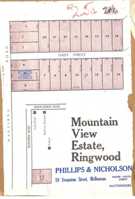 Ringwood and District Historical Society
Map, Partially Trimmed Copy of Mountain View Estate Subdivision Advertisement, Ringwood, Vic. - (Undated, circa 1930s)
Clipped subdivision map on cardboard backing. 22 residential allotments on Daisy Street and Wantirna Road, Ringwood.Auctioneers - Phillips & Nicholson, 59 Swanston Street, Melbourne. Phone Central 10907. -
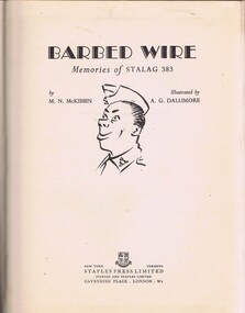 Greensborough Historical Society
Book, Barbed Wire: memories of Stalag 383, by M N McKibbin, 1947_
Tells the story of Prisoners of War at Stalag 383 during World War II. Personal memoirs of inmates (prisoners of war) of Stalag 383. 128p., hard cover, black and white illustrations.Inscription: "To Uncle Ame and, this book was prepared & paid for thru' army allotments whilst we were still p.o.w's, Allick.prisoners of war, world war ii, stalag 383. -
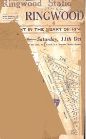 Ringwood and District Historical Society
Map, Partially Trimmed Copy of Ringwood Station Estate Auction Notice, Ringwood, Vic. - 1919
Triangular clipping from subdivision auction advertisement on cardboard backing. Faint handwritten sales notations on numbered residential allotments in Bedford Road and Williams Grove (later Lena Grove), Ringwood. -
Bendigo Historical Society Inc.
Map - CAMPBELL COLLECTION: BENDIGO AND DISTRICT MAPS
... allotments ...Map. Mandurang, Parish of Mandurang. Scale 20 chains to 1 inch. Total area 5993 acres. Northern Railway. (number 395 in map cupboard 1)map, bendigo, allotments -
Bendigo Historical Society Inc.
Map - CAMPBELL COLLECTION: BENDIGO AND DISTRICT MAPS, 16-4-29
... allotments ...Map. Kennington, Parishes of Sandhurst, Mandurang and Strathfieldsaye. Scale 20 chains to 1 inch. Total area 2918 acres. Prepared in W.P.B. from A. and C.L. Plans by W.J.Galbraith, 16-4-29. (number 394 in map cupboard 1)W.J.Galbraithmap, bendigo, allotments