Showing 204 items matching "bendigo and districts map"
-
 Bendigo Historical Society Inc.
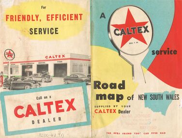
Document - J W SWATTON COLLECTION: MAP OF NEW SOUTH WALES
Two Road maps of New South Wales. C M Jones, Caltex Dealer, Golden Square, Bendigo stamped on the front. Map shows Sydney Outlet Roads, City of Sydney, City of canberra, Newcastle District, Motor tours Around Sydney, Routes to Brisbane, Road Map of New South Wales. It also lists the Principal Towns with Distances from Sydney and Interstate Road Mileages including Sydney to Melbourne via Hume Highway, Prince's Highway, via Canberra & Bombala. Also Sydney to Adelaide via Hume & Sturt Highways, Sydney to Brisbane via New England Highway, Pacific Highway via Toowoomba and Sydney to Adelaide via Western, Mid-Western and Sturt Highways.person, receipts, j w swatton, j w swatton collection, road map of new south wales, caltex, c m jones, e s sculley, clive barrass -
 Bendigo Historical Society Inc.
Photograph - 1.25,000 BENDIGO AERIAL PHOTOGRAPHS
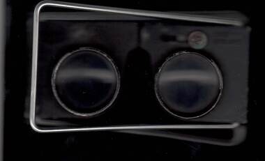
Eighteen undated coloured 1.25,000 army aerial photographs covering Bendigo city and district. [a] -( Similar to A vintage Abrams map reader -Adjustable Stereoscope) -Casella London viewing eye frame with Irving scratched into frame. Another name scratched out also. [b] WW2 Leather pouch stamped Casella London made to hold eye frame.bendigo, utilities, fortuna army mapping division -
 Bendigo Historical Society Inc.
Map - ST ARNAUD MAP, 1968
... Colour map of St Arnaud district printed by Royal... Arnaud district printed by Royal Australian Survey Corps 1968 Map ...Colour map of St Arnaud district printed by Royal Australian Survey Corps 1968Royal Australian Survey Corpsmap, victoria, starnaud -
 Bendigo Historical Society Inc.
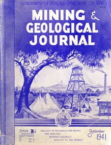
Book - MINING & GEOLOGICAL JOURNAL, September, 1941
Mining & Geological Journal September 1941, Geology in the search for metals, fire assaying, Bendigo goldfields, Geology of Yea district published half yearly by the Department of Mines Victoria contains photographs, maps and illustrations.gold, mining, journal -
 Bendigo Historical Society Inc.
Map - CAMPBELL COLLECTION: BENDIGO AND DISTRICT MAPS, 1982
... Bendigo forest district Map. Forest Commission Victoria, Bendigo ...Map. Forest Commission Victoria, Bendigo Forest District, Sub-Plan 1 District Fire Prevention Plan, Greater Bendigo Area. Prevention Strategy Plan. Shire of Marong, Shire of Huntly, Borough of Eaglehawk, Shire of Strathfieldsaye, Sailors Gully, Epsom, Jackass Flat, White Hills, California Gully, Maiden Gully, Long Gully, North Bendigo, City of Bendigo, Bendigo East, Kennington, West Bendigo, Golden Square, Quarry Hill, Flora Hill, Spring Gully, Kangaroo Flat.Base prepared 1982. (number 397 in map cupboard 1)map, bendigo, forest district -
Bendigo Historical Society Inc.
Map - CAMPBELL COLLECTION: BENDIGO AND DISTRICT MAPS, 21-8-1972
... cupboard 1) Map CAMPBELL COLLECTION: BENDIGO AND DISTRICT MAPS ...Map. Shire of Strathfieldsaye Locality Plan. Scale 1 inch=1 mile. Drawn by M.Higgs 21-8-1972, Shire of Huntly, Shire of McIvor, City of Bendigo, Shire of Marong, Shire of Maldon, Shire of Metcalfe, Lake Eppalock, Axedale Township, Strathfieldsaye Township, Melbourne to Bendigo Railway Line, Big Hill Tunnel, Mt.Herbert 1596. (number 398 in map cupboard 1)M.Higgs 21-8-1972map, bendigo, locality plan -
Bendigo Historical Society Inc.
Map - CAMPBELL COLLECTION: BENDIGO AND DISTRICT MAPS, 10-5-29
... : BENDIGO AND DISTRICT MAPS ...Map. Mandurang, Scale 20 chains to an inch. Total area 5746 acres. Kennington, Township of Mandurang. To accompany my report of 10-5-29 R. Marshall, Forest assessor. Drawn by I.M.K. (number 399 in map cupboard 1)I.M.K.map, bendigo, allotments -
Bendigo Historical Society Inc.
Map - CAMPBELL COLLECTION: BENDIGO AND DISTRICT MAPS, 6-4-28
... COLLECTION: BENDIGO AND DISTRICT MAPS ...Map. Sedgwick, Parishes of Strathfieldsaye, Lyell, and Sedgwick. Scale 20 chains to 1 inch. Total area 5372 acres. Prepared in W.P.B. from C.L.and A. Plans by W.J.Galbraith 6-4-28. (number 400 in map cupboard 1)W.J.Galbraith.map, bendigo, agricultural lands -
Bendigo Historical Society Inc.
Map - CAMPBELL COLLECTION: BENDIGO AND DISTRICT MAPS, 1962
... cupboard 1) Map CAMPBELL COLLECTION: BENDIGO AND DISTRICT MAPS. ...Map. Mandurang, County of Bendigo. Scale 40 chains to 1 inch. Sandhurst, Strathfieldsaye, Sedgwick, Sutton Grange, Ravenswood, Lockwood, Township of Kangaroo Flat, Township of Mandurang. By Authority A.C. Brooks, Government Printer, Melbourne. Drawn and Reproduced at the Department of Lands and Survey, Melbourne,1962, Price 2/-. (number 401 in map cupboard 1)A.C. Brooks, Government Printer.map, bendigo, allotments -
Bendigo Historical Society Inc.
Map - CAMPBELL COLLECTION: BENDIGO AND DISTRICT MAPS, March 1947
... CAMPBELL COLLECTION: BENDIGO AND DISTRICT MAPS. ...Map. Mandurang, County of Bendigo, Sandhurst, Strathfieldsaye, Sedgwick, Sutton Grange, Ravenswood, Lockwood. Scale 40 chains to 1 inch. Drawn and reproduced at the Department of Lands and Survey, Melbourne, March 1947, price 2/-. By Authority : J.J. Gourley, Government Printer, Melbourne. (number 402 in map cupboard 1)J.J. Gourley, Government Printer.map, bendigo, allotments -
Bendigo Historical Society Inc.
Map - CAMPBELL COLLECTION: BENDIGO AND DISTRICT MAPS, June 1953
... AND DISTRICT MAPS. ...Map. Marong, County of Bendigo, Scale 40 chains to 1 inch. Woodstock, Leichardt, Nerring, Sandhurst, Lockwood, Shelbourne. Drawn and reproduced at the Department of Lands and Survey, Melbourne, Victoria. By Authority : W.M. Houston, Government Printer. June 1953. Price 2/-. (number 403 in map cupboard 1)W.M. Houston, Government Printer.map, bendigo, agricultural lands -
Bendigo Historical Society Inc.
Map - CAMPBELL COLLECTION: BENDIGO AND DISTRICT MAPS, August 1952
... : BENDIGO AND DISTRICT MAPS. ...Map. Nerring, County of Bendigo, Yarraberb, Neilborough, Leichardt, Marong, Sandhurst, Huntly. Scale 20 chains to 1 inch. Drawn and reproduced at the Department of Lands and Survey, Melbourne, Victoria, August 1952. Price 2/-. By Authority J.J. Gourley, Government Printer, Melbourne. (number 404 in map cupboard 1)J.J. Gourley, Government Printermap, bendigo, allotments -
Bendigo Historical Society Inc.
Map - CAMPBELL COLLECTION: BENDIGO AND DISTRICT MAPS, 1963
... CAMPBELL COLLECTION: BENDIGO AND DISTRICT MAPS. ...Map. Sedgwick, County of Bendigo. Scale 20 chains to 1 inch. Strathfieldsaye, Eppalock, Lyell, Mandurang, Sutton Grange, County of Talbot. By Authority A.C. Brooks,Government Printer, Melbourne. Drawn and reproduced at the Department of Lands and Survey, Melbourne.1963. Price 2/-. (number 405 in map cupboard 1)A.C. Brooks, Governmenr Printer, Melbourne.map, bendigo, allotments -
Bendigo Historical Society Inc.
Map - CAMPBELL COLLECTION: BENDIGO AND DISTRICT MAPS, 11-2-37
... : BENDIGO AND DISTRICT MAPS. ...Map. Parish of Shelbourne, County of Bendigo. Scale 40 chains to 1 inch. Drawn and reproduced at the Department of Lands and Survey, Melbourne, Victoria. Price 2/-.11-2-37. By Authority H.J. Green, Government Printer, Melbourne.H.J. Green, Government Printermap, bendigo, agricultural lands -
Bendigo Historical Society Inc.
Map - BENDIGO AND DISTRICT PARISH MAPS, 21-10-26
... /-. (number 13 in map cupboard 1) Map BENDIGO AND DISTRICT PARISH MAPS ...Map. Sandhurst, County of Bendigo, City of Bendigo, Strathfieldsaye, Mandurang, Marong, Nerring, Borough of Eaglehawk, Township of Kangaroo Flat, Lockwood, Huntly, Epsom, Wellsford. By Authority H.J. Green, Government Printer, Photo-Lithographed at the Department of Lands and Survey, Melbourne bj W.J Butson 21-10-26,Price 1/-. (number 13 in map cupboard 1)By Authority H.J. Green, Govt. Printermap, bendigo, sandhurst -
 Bendigo Historical Society Inc.
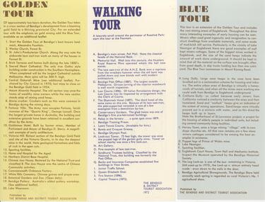
Document - BENDIGO TOURISM BROCHURES COLLECTION: THREE SINGLE SHEET TOUR BROCHURES, 1960's
Document. Three single sheet tour brochures with maps printed on the Reverse, Published by the Bendigo and District Tourist Association. a. Yellow brochure ""Golden Tour''. Outlines a two hour driving tour of Bendigo and White Hills. b. White brochure outlining ''a Walking Tour'' along Pall Mall and through Rosalind park. c. Blue brochure " Blue Tour''. Outlines a driving tour around Eaglehawk.document, memo, three single sheet tour brochures -
 Bendigo Historical Society Inc.
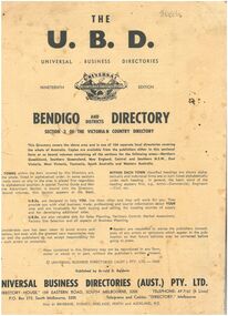
Booklet - The Universal Business Directory (UBD)
The Nineteenth Edition of the Bendigo and Districts Universal Business Directory, which is Section 3 of the Victorian Country Directory for 1969. The directory includes classified sections for Bendigo and surrounding towns, including Carisbrook, Castlemaine, Eppalock, Harcourt, Malmsbury, Maryborough, Newbridge, Raywood, Tooborac and Yapeen. It also includes an Eaglehawk Traders section, emergency phone numbers and maps of Bendigo, Castlemaine, Kangaroo Flat and Maryborough. The booklet is made of soft flimsy paper with black print and contains 51 pages.There is a grey lead scribble on back page between the '6' and '7'.bendigo businesses, bendigo maps, 1960s, bendigo business directory -
 Bendigo Historical Society Inc.
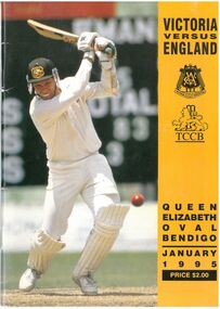
Booklet - Cricket Match Record
Record of the Victoria versus England Cricket match played at the Queen Elizabeth Oval (QEO) in January 1995. The booklet includes profiles of the English and Victorian players, a summary of the history of English cricket in Bendigo, a picture of the QEO grandstand in 1901-1902, results of England teams who had previously played in Bendigo, local cricketers, scorecards and a map of the QEO. The autograph page has two autographs added. The booklet has 25 pages. There is also a yellow advertising feature page intact, in the middle of the booklet.Two autographs have been added on the autograph page in thick black marker.cricket, 1990s, queen elizabeth oval, england, bendigo district cricket association, cricket team, victorian cricket association, bendigo cricket, international cricket -
 Bendigo Historical Society Inc.
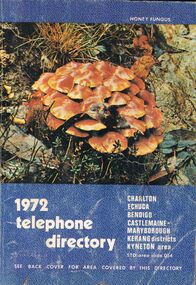
Book - BOOK - 1972 TELEPHONE DIRECTORY
A copy of the 1972 Telephone Directy for Charlton, Echuca, Bendigo, Castlemaine, Maryborough, Kerang Districts, Kyneton area. The book is blue with a unique pattern and has a picture of the local flora.The back cover features of a map of the Bendigo Area.book, rural -
 Bendigo Historical Society Inc.
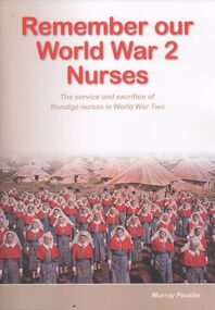
Book - REMEMBER OUR WORLD WAR 2 NURSES
Soft covered book, Remember our World War 2 Nurses, the service and sacrifice of Bendigo nurses in World War Two, 150 pages with black and white photographs & maps, researched and written by Murray Poustie, published by the Northern District School of Nursing Graduates Association Inc, printed in Bendigo by Bendigo Modern Press.Murray Poustiebooks, military, nursing, bendigo-nursing-ww2 -
 Bendigo Historical Society Inc.
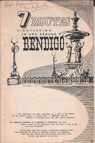
Document - BENDIGO CHAMBER OF COMMERCE & INDUSTRIES BOOKLET - 7 TOUTES SIGHTESEEING IN AND AROUND BENDIGO
Booklet produced for the Bendigo Chamber of Commerce & Industries 7 ROUTES sightseeing in and around Bendigo Black & white, 32 page booklet, plus extrended cover Two maps on inside front (Bendigo route) and rear (District routes) covers Four half-day routes * 1st Bendigo, * 2nd Eppalock etc. * 3rd Castlemaine & * 7th Whipstick Hill Three day routes * 4th Maryborough etc., * 5th Kyneton, Daylesford, etc., * 6th Wedderburn, etc.Hedges & Bell, Maryborough -
 Bendigo Historical Society Inc.
Document - OLD TOM LEASE MAP
Hand Drawn map of Old Tom Lease - Parish of Huntly, County of Bendigo, Mining district of Sandhurst.place, land, mining -
 Bendigo Historical Society Inc.
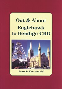
Book - OUT & ABOUT EAGLEHAWK TO BENDIGO CBD, 2007
... COTTAGE Miners Plaques monuments buildings maps buildings Bendigo ...Out & About Eaglehawk to Bendigo CBD .Plaques monuments, buildings, maps, buildings. 88 pages. Includes B&W photosJean & Ken Arnoldcottage, miners, plaques monuments, buildings, maps, buildings, bendigo and district -
 Bendigo Historical Society Inc.
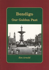
Book - BENDIGO OUR GOLDEN PAST, 2007
Bendigo Our Golden Past. Signed by Ken Arnold 2007. History of Bendigo. Photographs: black and white. Street maps, copy opf painting. 80 pages. Signed by: Ken Arnold, December 2007. 80 pages.Ken Arnoldbendigo, history, bendigo & district, history of bendigo -
Bendigo Historical Society Inc.
Map - PASTORAL HOLDINGS, See above
... Inc. History House 11 Mackenzie Street Bendigo goldfields MAP ...Map: Copy of 'Map showing the Pastoral Holdings of the Port Phillip District 1835-51, Now Victoria'. Comiled by A.S.Kenyon M.I.E. Aus. Historical society of Victoria 1932map, victoria, pastoral holdings, pastoral holdings, port phillip district -
Bendigo Historical Society Inc.
Map - BENDIGO (COUNTY), Circa 1870's
Map:Plan showing the whole of the County of Bendigo-- attached handwritten sheet in the top left hand corner-'Proclaimed Commons Sandhurst District'. Also attached is a separate plan of the parish of Kimbolton (number 262 in map cupboard 1)map, bendigo, parish plan, bendigo, proclaimed commons -
 Bendigo Historical Society Inc.
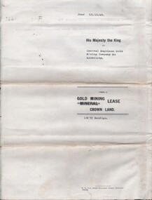
Document - MCCOLL, RANKIN AND STANISTREET COLLECTION: CENTRAL NAPOLEON GOLD MINING CO. N.L, 15th August 1950
... of Central Napoleon Gold Mining Co N.L & King George VI, Map... Co N.L & King George VI, Map: No 11272 Mining District ...Document: Gold Mining Lease Crown Land No 11272 Bendigo, entered in the register book Vol 331 Fol 36450, embossed seals of Central Napoleon Gold Mining Co N.L & King George VI, Map: No 11272 Mining District of Bendigo, Parish of Sandhurst, County of Bendigo, shows the minerunning between Harvey & Inglis Streets and crossing Empire and Sparrowhawk Roads and running a good distance beyond Sparrowhawk Rd.organization, business, industrial - mining, mccoll rankin & stanistreet, mining, gold mining, central napoleon -
 Bendigo Historical Society Inc.
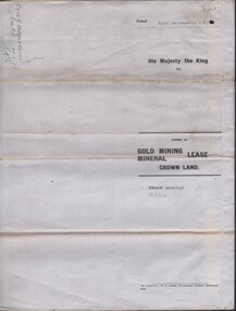
Document - MCCOLL, RANKIN AND STANISTREET COLLECTION: CENTRAL NAPOLEON GOLD MINING CO. N.L, 15th December 1934
... of Central Napoleon Gold Mining Co N.L. & King George V, Map... Co N.L. & King George V, Map: No 10260, Mining district ...Document: Gold Mining Lease Crown Land, No 10260 Bendigo, Entered in the register book vol. 307 fol. 34041, embossed seals of Central Napoleon Gold Mining Co N.L. & King George V, Map: No 10260, Mining district of Bendigo, Parish of Sandhurst, County of Bendigo, During the Reign of King George V.organization, business, industry - mining, mccoll rankin & stanistreet, mining, gold mining, central napoleon -
 Bendigo Historical Society Inc.
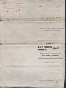
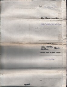
Document - MCCOLL, RANKIN AND STANISTREET COLLECTION: CENTRAL NELL GWYNNE - FORM D GOLD MINING LEASE 10981 BENDIGO, 5 Oct 1936
Document. Renewal New Lease no 11073 His Majesty the King to Central Nell Gwynne GMC N/L. 1 map no 10981 of Mining District of Bendigo Parish of Sandhurst City of Bendigo County of Bendigo. No 10981 Bendigo Vo 322 Fol 35594.McColl, Rankin & Stanistreetorganization, business, central nell gwynne, mccoll, rankin & stanistreet, cnetral nell gwynne, gold mining, lease -
 Bendigo Historical Society Inc.
Document - MCCOLL, RANKIN AND STANISTREET COLLECTION: CENTRAL NELL GWYNNE, 5/10/1941
... Mining Company No Liability. Included is a map of the mining... Company No Liability. Included is a map of the mining district ...Document. Paper Document containing an indenture detailing lease between His Majesty the King to Central Nell Gwynne Gold Mining Company No Liability. Included is a map of the mining district of Bendigo Parish of Sandhurst. No 11172 Bendigo Vol 327 Fol 36016.McColl, Rankin & Stanistreetorganization, business, central nell gwynne, mccoll, rankin & stanistreet, central nell gwynne, gold mining, lease