Showing 247 items
matching box hill north
-
 Ballarat Heritage Services
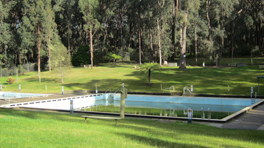
Photograph - digital photographs, Lisa Gervasoni, Mirboo North Pre Olympic Swimming Pool, c2010
Colour photograph of Mirboo North Pre Olympic Swimming Poolswimming pool, sport, swimming, pre olympic, mirboo north swimming pool, mirboo north -
 Ballarat Heritage Services
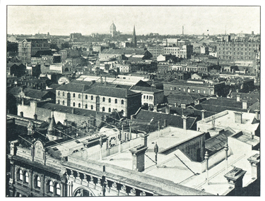
Image, Melbourne, From the Equitable Building, Looking North-East
Black and white image of Melbourne.melbourne -
 Ballarat Heritage Services
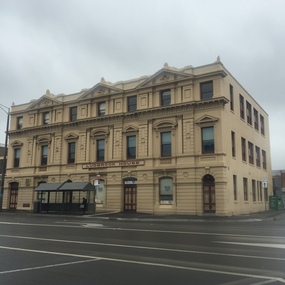
Photograph - Colour, Ludbrook House, Lydiard Street, Ballarat, 2016, 19/09/2016
ludbrook house, lydiard street north, ballarat, streetscape, architeture -
 Ballarat Heritage Services
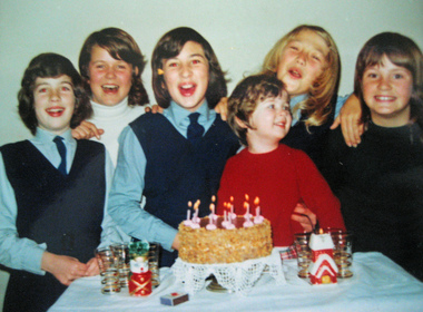
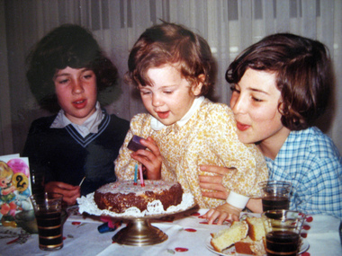
Photograph - Colour, Kathleen Gervasoni, Birthday Party, c1972, c1972
Colour photograph of Ann Gervasoni's birthday party held at 93 Willsmere Road Kew (behind North Kew Newsagency). Some of the partygoers wear the uniform of St Anne's East Kew. Left to right: Clare Gervasoni, Sally Ann Estella, Ann Gervasoni, Lisa Gervasoni (red jumper), Eve Urban, Genevieve Rayson.birthday, gervasoni, birthday cake, st anne's east kew uniform -
 Ballarat Heritage Services
Photograph, Kathleen Gervasoni, Birthday Party, November 1971, 1971
Colour photograph of Lisa Gervasoni's second birthday party held at 93 Willsmere Road Kew (behind North Kew Newsagency). Left to right: Clare Gervasoni (in the old summer uniform of St Anne's East Kew), Lisa Gervasoni, and Ann Gervasoni (in the new summer uniform of St Anne's East Kew).birthday, gervasoni, birthday cake, st anne's east kew uniform, st anne's east kew -
 Ballarat Heritage Services
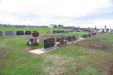
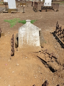
Photograph - Photograph - Colour, Clare Gervasoni, Tower Hill Cemetery, 2009, 26/07/2009
The Tower Hill Cemetery is located near Koroit on the north side of the Princes Highway The, between Port Fairy and Warrnambool. The first burial at Tower Hill Cemetery took place in 1856. Over 150 years there has been over 8,000 burials. Around 45 percent of the burials are in unmarked graves.Colour photograph of a headstone in the Tower Hill Cemetery.tower hill cemetery, william rutledge, eliza rutledge -
 Ballarat Heritage Services
Photograph - Photograph - Colour, Clare Gervasoni, Tower Hill Cemetery, 2009, 26/07/2009
The Tower Hill Cemetery is located near Koroit on the north side of the Princes Highway The, between Port Fairy and Warrnambool. The first burial at Tower Hill Cemetery took place in 1856. Over 150 years there has been over 8,000 burials. Around 45 percent of the burials are in unmarked graves.Colour photograph of a headstone in the Tower Hill Cemetery.tower hill cemetery -
 Ballarat Heritage Services
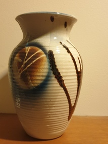
Ceramic - Artwork - Ceramics, Pottery Vase by Mark Reid
Mark REID Mark Reid began working with clay in the early 1980s, working for a time at Kairi Pottery in North Queensland. In 1985, he and his wife Robyn set up the Torvil Pottery at Buninyong, Victoria. In 1991, they relocated to a 10 acre property in nearby Magpie and set up the Ballarat Clayfire Gallery with a working studio, gallery and residence. In 2005, the Clayfire Gallery was located to Daylesford. Reid signs his work with an incised 'Mark Reid' or 'MR'. Photograph of a hand thrown ceramic vase. australian landscape pottery, gilbert buchanan, graham wood, landscape, redbyrne pottery, ceramics, shepparton, torvil pottery, ballarat clayfire gallery -
 Ballarat Heritage Services
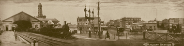
Photograph - Image - Black and White, Ballarat Railway Station, c1904, c1904
The Ballarat to Melbourne Railway line opened in 1862.Black and white panoramic view of the Ballarat Railway Station. A steam train is about to cross Lydiard Street North, and the railway gates are shut to prevent cars crossing the tracks. ballarat railway station, signals, railway track, provincial hotel, railway gates -
 Ballarat Heritage Services
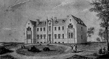
Photograph - Image, Ham Brothers, Benevolent Asylum, North Melbourne, c1851, 1851
Black and white image of the Benevolent Asylum at North Melbourne. thomas ham, benevolent asylum, melbourne benevolent asylum, north melbourne -
 Ballarat Heritage Services
Photograph, Lisa Gervasoni, Former Cuthbert's Legal, Lydiard Street North, Ballarat, 15/08/2007
Former Cuthbert's Legal on the corner of Lydiard Street North and Mair Street, a double storey building on bluestone footings. cuthbert's legal, lydiard street north, architecture -
 Ballarat Heritage Services
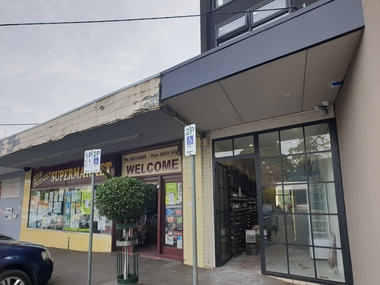
Photograph, Clare Gervasoni, Willsmere Village Supermarket, 2022, 16/07/2022
The North Kew Village Supermarket survived the Covid19 lockdowns, but according to locals the rent was put up and the supermarket became unviable and was foced to close. In the 1960s the supermarket was owned by Tainsshes. The North Kew Village Supermarket during a closing down sale.supermarket, north kew village supermarket, tainshes -
 Ballarat Heritage Services
Photograph, Ballarat Looking North-east from the Town Hall Tower, 14/12/1895
Photograph published in the Australasian of Ballarat Looking North-east from the Town Hall Towerballarat, ballarat town hall, ballarat post office, ballarat railway station -
 Ballarat Heritage Services
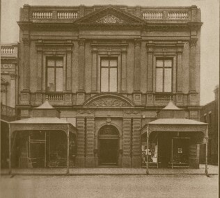
Photograph, Ballarat Fine Art Gallery
Black and white image of the Ballarat Fine Art Gallery (later Art Gallery of Ballarat) in Lydiard Street North, Ballarat. art gallery of ballarat, ballarat fine art gallery, lydiard street north -
 Ballarat Heritage Services
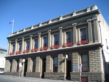
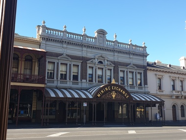
Photograph - Image, Clare Gervasoni, Ballarat Mining Exchange, 2020, 16/05/2020
This photo was taken during 'Lock Downs' during the Covid19 Pandemic. Colour photograph of the Mining Exchange in Lydiard Street North, Ballarat.lydiard street north, ballarat mining exchange, stockbrockers, pandemic, covid 19 -
 Ballarat Heritage Services
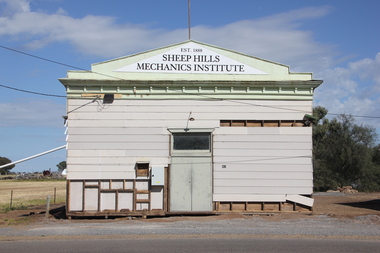
Photograph, Clare Gervasoni, Sheep Hills Mechanics' Institute, 08/10/2017
Sheep Hills is located Sheep Hills in the northern Wimmera region, north-west Victoria between Warracknabeal and Minyip.The Sheep Hills Mechanics' Institute was established in 1888.Weatherboard Mechanics' Institute at Sheep Hills Victoriasheep hills, sheep hills mechanics' institute -
 Ballarat Heritage Services
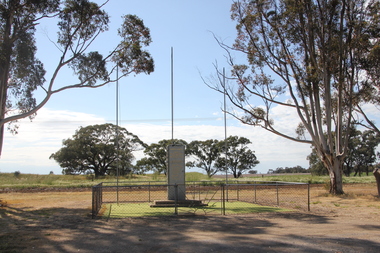
Photograph, Clare Gervasoni, Sheep Hills War Memorial, 2017, 08/10/2017
Sheep Hills is located Sheep Hills in the northern Wimmera region, north-west Victoria between Warracknabeal and Minyip.The Sheep Hills cenataph is opposite the Mechanics' Institute. The cenotaph commemorates those from the district who served in World Wars One and Two and lists the names of those who died in the conflict. Sheep Hills War Memorialsheep hills, sheep hills cenataph, sheep hills war memorial, allan albert, walter robert childs, joseph william darling, william pleass gove, george laing, herman percy robert schultz -
 Ballarat Heritage Services
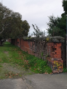
Photograph, Clare Gervasoni, Remnant Wall from the Ballarat East Railway Workshops
Remnant Wall from the Ballarat East Railway Workshops at the intersection of King Street NOrth and Corbett Street Ballarat East.ballarat east railway workshops, brick wall, bluestone -
 Ballarat Heritage Services
Photograph - Image, Elizabeth Street Melbourne Looking North, 1865
A colour image Elizabeth Street, Melbourne. princes bridge, queen's bridge, yarra river, rowboats -
 Ballarat Heritage Services
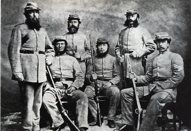
Photograph - Image, North Melbourne Rifle Regiment
A photograph of six uniformed men of the North Melbourne Rifle Regiment.north melbourne rifle regiment, volunteer regiments, rifles -
 Ballarat Heritage Services
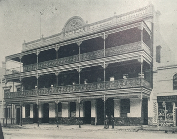
Photograph, George Hotel, Lydiard Street North, Ballarat, c1900
Originally called the George Inn, this hotel was established in 1853.Three storey hotel in Lydiard Street North, Ballaratballarat, george hotel, lydiard street north -
 Ballarat Heritage Services
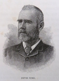
Photograph - Image, David Syme
David Syme (1827-1908) was a newspaper proprietor who was born on 2 October 1827 at North Berwick, Scotland. Early in 1851, he went via Cape Horn to California seeking gold. By mid-1852 he was in Melbourne, and in the next three years prospected with some success on Ballarat, Bendigo, Castlemaine and Beechworth diggings. In 1855 he lost a possible fortune at Egerton near Ballarat when a promising claim was jumped. Ebenezer Syme bought the insolvent Melbourne Age for £2000, and invited David Syme to take up a share. In September 1856 Syme put up some cash and his contracting business to obtain a half-share. He helped to manage the paper but returned to contracting late in 1857. When Ebenezer retired in 1859 Syme reluctantly returned to the business, and on Ebenezer's death next year he began his fifty-year career as publisher and editor of the Age. (C. E. Sayers, 'Syme, David (1827–1908)', Australian Dictionary of Biography, National Centre of Biography, Australian National University, http://adb.anu.edu.au/biography/syme-david-4679/text7741, published first in hardcopy 1976, accessed online 25 August 2019._Reproducation of a image of David Syme.david syme, portrait, the age, journalist -
 Ballarat Heritage Services
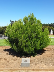
Photograph - Photograph - Colour, Clare Gervasoni, Aleppo Pine, Tower Hill Cemetery, 2019, 03/01/2019
The Tower Hill Cemetery is located near Koroit on the north side of the Princes Highway The, between Port Fairy and Warrnambool. The first burial at Tower Hill Cemetery took place in 1856. Over 150 years there has been over 8,000 burials. Around 45 percent of the burials are in unmarked graves. In 2023 this tree was no longer in existence, and a smaller tree was struggling in this site.Colour photographs of an Aleppo Pine planted in the Tower Hill Cemetery to mark the centenary of the landing at Galipolli.aleppo pine, anzac centenary, centenary, anniversary, tower hill cemetery, gallipoli -
 Ballarat Heritage Services
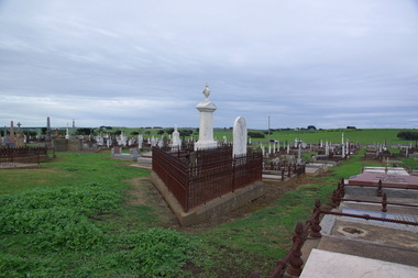
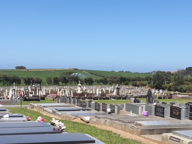
Photograph - Photograph - Colour, Clare Gervasoni, Tower Hill Cemetery, 2019, 03/01/2019
The Tower Hill Cemetery is located near Koroit on the north side of the Princes Highway The, between Port Fairy and Warrnambool. The first burial at Tower Hill Cemetery took place in 1856. Over 150 years there has been over 8,000 burials. Around 45 percent of the burials are in unmarked graves. Colour photograph of the Tower Hill Cemetery. with potatoes being irrigated in te background. The cemetery is laid out on design of a Celtic Cross.tower hill cemetery, tower hill, cemetery -
 Ballarat Heritage Services
Photograph - Photograph - Colour, Clare Gervasoni, Headstone of Patrick Carroll in Tower Hill Cemetery, 2019, 03/01/2019
The Tower Hill Cemetery is located near Koroit on the north side of the Princes Highway The, between Port Fairy and Warrnambool. The first burial at Tower Hill Cemetery took place in 1856. Over 150 years there has been over 8,000 burials. Around 45 percent of the burials are in unmarked graves.Colour photograph of the headstone of Patrick Carroll in the Tower Hill Cemetery. . by Patrick Carroll InLoving Remembrance of my beloved son Patrick Who departed this life the 20th day of April 1874 Aged 2 years and 2 months Also his beloved mother Who departed this life 15th Sept 1876 Aged 74 years Also his who died 16th November 1890 Aged 89 Years Also Patrick Carroll Who died 10 July 1906 aged 72 years Rest in Peace tower hill cemetery, patrick carroll -
 Ballarat Heritage Services
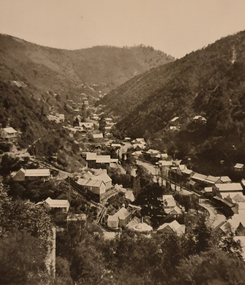
Photograph - Image - Black and White, Walhalla Looking North, c1903, c1903
Walhalla is a historic gold mining town nestled in a scenic valley in the Victorian Alps. It is named for the German hall of fame, the Walhalla temple,Sepia image of the Victorian goldtown Walhalla.walhalla, mining, townscape, gippsland -
 Ballarat Heritage Services
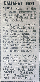
Newspaper - Newspaper clipping, Ballarat East High School, c1957
Ballarat East: This year is the third anniversary of the opening of our modern Ballarat East High School. We are growing, with 360 pupils, ranging from the first to the fourth form. At our speech night last year, we had Kevan Gosper (a member of the Australian Olympic Team) to present the sports awards. We are also to be represented for the first time at the combined swimming sports in the new Olympic pool. - Lynette Pascoe (14) Humffray St North, Ballarat East.A newspaper clipping concerning the early days of Ballarat East High School. behs, ballarat east high school, ballarat east, magazine, kevan gosper, 1957 -
 Ballarat Heritage Services
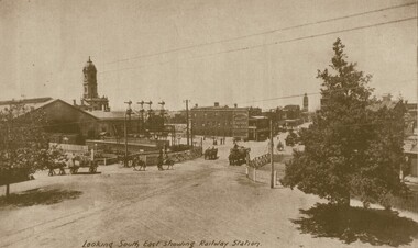
Photograph - Image, Looking South East Showing the Ballarat Railway Station
Ballarat looking South East from the Ballarat Railway Station. ballarat railway station, ballarat railway gates, lydiard street ballarat, reid's coffee palace, lydiard street north -
 Ballarat Heritage Services
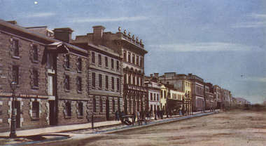
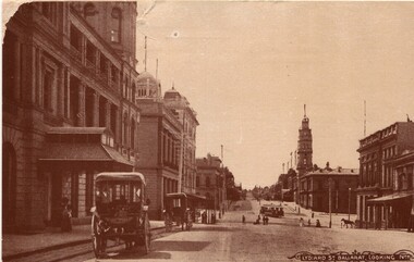
Photograph - Image, Lydiard Street Ballarat Looking North, C1890
Lydiard Street is a street in central Ballarat known for its Victorian architecture. The building with clock tower is the former Ballarat Post Office, the tower stage of the building dating from 1885. It sits on the corner of Sturt Street. Black and white photograph of Lydiard Street Ballarat.lydiard street ballarat, ballarat post office, tram, streetscape, architecture, vintage cars