Showing 176 items matching "campaspe"
-
 Bendigo Historical Society Inc.
Map - Laminated map of Lake Eppalock at full capacity. Map 'E'
John Perry Collection. Laminated map of Lake Eppalock at full capacity. Black and white. The dam was built by the State Rivers and Water Supply Commission of Victoria. The dam wall height is 45 metres (148 ft) and the main embankment is 1,041 metres (3,415 ft) long. At 100% capacity the dam wall was designed to hold back 304,651 megalitres (6.7014×10¹⁰ imp gal; 8.0480×10¹⁰ US gal) of water. The surface area of Lake Eppalock is 3,011 hectares (7,440 acres) and the catchment area is 2,124 square kilometres (820 sq mi). The controlled spillway is capable of discharging 8,040 cubic metres per second (284,000 cu ft/s). Lake Eppalock supplies both stock and domestic water to the Campaspe irrigation district. It also serves as a water supply to Bendigo and Heathcote and, in more recent times, Ballarat. The lake is a major attraction for those engaging in watersports, with a number of tourist parks and accommodation facilities available. Permissible activities on the lake include high-speed boating, water skiing, sailing, canoeing, fishing and swimming. The lake's water levels were low for approximately eight years between 2002 and 2010 during a prolonged drought, which restricted the amount of recreational activity until rainfall in the latter half of 2010 returned the lake to 100 percent capacity. Built between 1961 and 1964, Lake Eppalock remains the only water storage on the Campaspe River system.map, eppalock, water, dam, reservoir -
 City of Greater Bendigo - Civic Collection
Photograph - Portrait of Councillor Brennan, W H Robinson
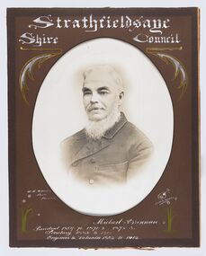
The district of Strathfieldsaye was proclaimed in 1861 and named a Shire on the 17th September in 1866. It remained a shire until amalgamation in 1994 when it became part of the City of Greater Bendigo. The shire was located 8 km to the south- east of Bendigo and covered an area of 601 square kilometres and extended from the Calder Highway to the Coliban and Campaspe Rivers. The shire's administration centre was in Strathfieldsaye until 1972 when new offices were opened in Kennington. Councillor Michael Brennan held roles of Shire Secretary and Clark of Works until around 1998 when his son R. B. Brennan was appointed Assistant Secretary and then Shire Secretary to assist his father with the work load during his later years. Michael Brennan remained Clerk of Works until his death at which time his son was appointed to the duties previously held by his father. Framed black and white head and shoulder portrait of Councillor Brennan with hand coloured and drawn detail. Profile to left. Cut oval brown mount decorated with text and flowers. Hand written title top and lower centreStrathfieldsaye / Shire Council / W H Robinson / Photo / Bendigo / J H B Gribble / Michael Brennan / President 1869 - 70. 1871 - 2. 1872 - 3 / Secretary 1882 to 1900 / Engineer & Valuator 1882 to 1902strathfieldsaye shire council, councillor brennan, president of strathfieldsaye shire -
 Bendigo Historical Society Inc.
Document - BARNEDOWN RUN: SHORT PAPER JOHN HARNEY
The original Barnedown Run consisted of 51,280 acres and was first taken up in 1839 by Henry Grey Bennett and was held under "Pre-emptive right" until it was subdivided in 1856 into Muskerry and Mt. Pleasant. In 1853 John Harney arrived in Australia and took up storekeeping at White Hills. In 1855 he took up land which was originally part of Barnedown Run and erected part of the present homestead. In 1860 Harney entertained Bourke and Wills exploration party at Adelaide Vale on the Campaspe River. Mr Harney owned a Hotel which was burnt down in 1861. Henry Grey Bennett a generous man died in1871 and the citizens of Bendigo erected a 20ft monument over his grave.John Harneyperson, individual, john harney, barnedown run, john harney, henry grey bennett, pre-emptive rights, white hills, adelaide vale, bourke and wills, edward o'keefe, cecil hyatt, mr frank k. hill. -
 Bendigo Historical Society Inc.
Plan - SANDHURST BOYS CENTRE COLLECTION: MASTER PLAN
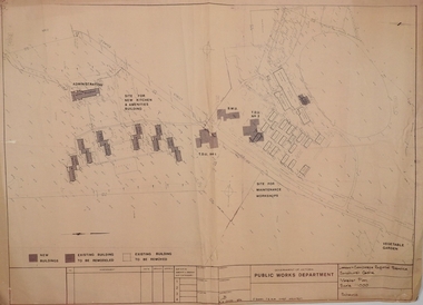
Government of Victoria. Public Works Department. Master plan for the Loddon-Campaspe Regional Service Sandhurst Centre. [produced by] J Swan Chief architect, approved by B.W. Swan. Shows a brick Administration building, 6 [accommodation?] brick buildings (to be remodelled), the site for a new kitchen & amenities building, TDU no 1, BMU, TDU no 2 (new buildings), sites for maintenance workshops, vegetable garden. Also shows a residence, garage, recreation oval, with 3 existing weatherboard buildings, galvanised iron building, a weatherboard grandstand, a galvanised iron shed, fowl shed, 14 galvanised iron buildings [probably Nissan huts] and 2 toilet blocks. Location unknown 16.02.2023.bendigo, institutions, sandhurst boys centre, victoria public works dept; plans; sandhurst boys centre; j.swan -
 Bendigo Historical Society Inc.
Map - Laminated map of Lake Eppalock at full capacity
John Perry Collection. Laminated copy of map of Lake Eppalock at full capacity. Had highlighter markings of old roads which appear to be still in use. The dam was built by the State Rivers and Water Supply Commission of Victoria. The dam wall height is 45 metres (148 ft) and the main embankment is 1,041 metres (3,415 ft) long. At 100% capacity the dam wall was designed to hold back 304,651 megalitres (6.7014×10¹⁰ imp gal; 8.0480×10¹⁰ US gal) of water. The surface area of Lake Eppalock is 3,011 hectares (7,440 acres) and the catchment area is 2,124 square kilometres (820 sq mi). The controlled spillway is capable of discharging 8,040 cubic metres per second (284,000 cu ft/s). Lake Eppalock supplies both stock and domestic water to the Campaspe irrigation district. It also serves as a water supply to Bendigo and Heathcote and, in more recent times, Ballarat. The lake is a major attraction for those engaging in watersports, with a number of tourist parks and accommodation facilities available. Permissible activities on the lake include high-speed boating, water skiing, sailing, canoeing, fishing and swimming. The lake's water levels were low for approximately eight years between 2002 and 2010 during a prolonged drought, which restricted the amount of recreational activity until rainfall in the latter half of 2010 returned the lake to 100 percent capacity. Built between 1961 and 1964, Lake Eppalock remains the only water storage on the Campaspe River system.map, water, dam, reservoir, eppalock -
 Bendigo Historical Society Inc.
Map - Laminated worksheet - identification of inundated artifacts at Lake Eppalock
John Perry Collection. Laminated copy of worksheet identifying inundated artifacts at Lake Eppalock when at 10% capacity. The dam was built by the State Rivers and Water Supply Commission of Victoria. The dam wall height is 45 metres (148 ft) and the main embankment is 1,041 metres (3,415 ft) long. At 100% capacity the dam wall was designed to hold back 304,651 megalitres (6.7014×10¹⁰ imp gal; 8.0480×10¹⁰ US gal) of water. The surface area of Lake Eppalock is 3,011 hectares (7,440 acres) and the catchment area is 2,124 square kilometres (820 sq mi). The controlled spillway is capable of discharging 8,040 cubic metres per second (284,000 cu ft/s). Lake Eppalock supplies both stock and domestic water to the Campaspe irrigation district. It also serves as a water supply to Bendigo and Heathcote and, in more recent times, Ballarat. The lake is a major attraction for those engaging in watersports, with a number of tourist parks and accommodation facilities available. Permissible activities on the lake include high-speed boating, water skiing, sailing, canoeing, fishing and swimming. The lake's water levels were low for approximately eight years between 2002 and 2010 during a prolonged drought, which restricted the amount of recreational activity until rainfall in the latter half of 2010 returned the lake to 100 percent capacity. Built between 1961 and 1964, Lake Eppalock remains the only water storage on the Campaspe River system.map, artifacts, eppalock, reservoir -
 Bendigo Historical Society Inc.
Map - Black and white map pertaining to Lake Eppalock
John Perry Collection. Laminated copy of map pertaining to Lake Eppalock. Gives details of dwellings, bridges and ford crossings. The dam was built by the State Rivers and Water Supply Commission of Victoria. The dam wall height is 45 metres (148 ft) and the main embankment is 1,041 metres (3,415 ft) long. At 100% capacity the dam wall was designed to hold back 304,651 megalitres (6.7014×10¹⁰ imp gal; 8.0480×10¹⁰ US gal) of water. The surface area of Lake Eppalock is 3,011 hectares (7,440 acres) and the catchment area is 2,124 square kilometres (820 sq mi). The controlled spillway is capable of discharging 8,040 cubic metres per second (284,000 cu ft/s). Lake Eppalock supplies both stock and domestic water to the Campaspe irrigation district. It also serves as a water supply to Bendigo and Heathcote and, in more recent times, Ballarat. The lake is a major attraction for those engaging in watersports, with a number of tourist parks and accommodation facilities available. Permissible activities on the lake include high-speed boating, water skiing, sailing, canoeing, fishing and swimming. The lake's water levels were low for approximately eight years between 2002 and 2010 during a prolonged drought, which restricted the amount of recreational activity until rainfall in the latter half of 2010 returned the lake to 100 percent capacity. Built between 1961 and 1964, Lake Eppalock remains the only water storage on the Campaspe River system.eppalock, map, water, dam, reservoir -
 Bendigo Historical Society Inc.
Map - Map of overlay of lake Eppalock at full capacity. Map 'C'
John Perry collection. Map 'C'. Laminated map of overlay of Lake Eppalock at full capacity. Circa 1951. The dam was built by the State Rivers and Water Supply Commission of Victoria. The dam wall height is 45 metres (148 ft) and the main embankment is 1,041 metres (3,415 ft) long. At 100% capacity the dam wall was designed to hold back 304,651 megalitres (6.7014×10¹⁰ imp gal; 8.0480×10¹⁰ US gal) of water. The surface area of Lake Eppalock is 3,011 hectares (7,440 acres) and the catchment area is 2,124 square kilometres (820 sq mi). The controlled spillway is capable of discharging 8,040 cubic metres per second (284,000 cu ft/s). Lake Eppalock supplies both stock and domestic water to the Campaspe irrigation district. It also serves as a water supply to Bendigo and Heathcote and, in more recent times, Ballarat. The lake is a major attraction for those engaging in watersports, with a number of tourist parks and accommodation facilities available. Permissible activities on the lake include high-speed boating, water skiing, sailing, canoeing, fishing and swimming. The lake's water levels were low for approximately eight years between 2002 and 2010 during a prolonged drought, which restricted the amount of recreational activity until rainfall in the latter half of 2010 returned the lake to 100 percent capacity. Built between 1961 and 1964, Lake Eppalock remains the only water storage on the Campaspe River system.map, water, eppalock, dam, reservoir -
 Bendigo Historical Society Inc.
Map - Laminated map of Lake Eppalock empty. Map 'D'
John Perry Collection. Laminated map of Lake Eppalock empty. Map 'D'. Circa 1951. The dam was built by the State Rivers and Water Supply Commission of Victoria. The dam wall height is 45 metres (148 ft) and the main embankment is 1,041 metres (3,415 ft) long. At 100% capacity the dam wall was designed to hold back 304,651 megalitres (6.7014×10¹⁰ imp gal; 8.0480×10¹⁰ US gal) of water. The surface area of Lake Eppalock is 3,011 hectares (7,440 acres) and the catchment area is 2,124 square kilometres (820 sq mi). The controlled spillway is capable of discharging 8,040 cubic metres per second (284,000 cu ft/s). Lake Eppalock supplies both stock and domestic water to the Campaspe irrigation district. It also serves as a water supply to Bendigo and Heathcote and, in more recent times, Ballarat. The lake is a major attraction for those engaging in watersports, with a number of tourist parks and accommodation facilities available. Permissible activities on the lake include high-speed boating, water skiing, sailing, canoeing, fishing and swimming. The lake's water levels were low for approximately eight years between 2002 and 2010 during a prolonged drought, which restricted the amount of recreational activity until rainfall in the latter half of 2010 returned the lake to 100 percent capacity. Built between 1961 and 1964, Lake Eppalock remains the only water storage on the Campaspe River system.map, water, dam, reservoir, eppalock -
 Bendigo Historical Society Inc.
Document - Legend to maps A, B and C for Lake Eppalock
John Perry Collection. Laminated 'legend' for Maps A, B and C for Lake Eppalock also in this collection. Black and White definitions and descriptions of objects and markers found on maps. Circa 1951. The dam was built by the State Rivers and Water Supply Commission of Victoria. The dam wall height is 45 metres (148 ft) and the main embankment is 1,041 metres (3,415 ft) long. At 100% capacity the dam wall was designed to hold back 304,651 megalitres (6.7014×10¹⁰ imp gal; 8.0480×10¹⁰ US gal) of water. The surface area of Lake Eppalock is 3,011 hectares (7,440 acres) and the catchment area is 2,124 square kilometres (820 sq mi). The controlled spillway is capable of discharging 8,040 cubic metres per second (284,000 cu ft/s). Lake Eppalock supplies both stock and domestic water to the Campaspe irrigation district. It also serves as a water supply to Bendigo and Heathcote and, in more recent times, Ballarat. The lake is a major attraction for those engaging in watersports, with a number of tourist parks and accommodation facilities available. Permissible activities on the lake include high-speed boating, water skiing, sailing, canoeing, fishing and swimming. The lake's water levels were low for approximately eight years between 2002 and 2010 during a prolonged drought, which restricted the amount of recreational activity until rainfall in the latter half of 2010 returned the lake to 100 percent capacity. Built between 1961 and 1964, Lake Eppalock remains the only water storage on the Campaspe River system.map, water, dam, reservoir, eppalock -
 Bendigo Historical Society Inc.
Document - Collection of photographs from newspaper on a single page
John Perry Collection. Laminated copy of page from 'Weekly Times' newspaper, February, 1962. Nine images relating to establishing and building Eppalock Reservoir, 15 miles from Bendigo. The dam was built by the State Rivers and Water Supply Commission of Victoria. The dam wall height is 45 metres (148 ft) and the main embankment is 1,041 metres (3,415 ft) long. At 100% capacity the dam wall was designed to hold back 304,651 megalitres (6.7014×10¹⁰ imp gal; 8.0480×10¹⁰ US gal) of water. The surface area of Lake Eppalock is 3,011 hectares (7,440 acres) and the catchment area is 2,124 square kilometres (820 sq mi). The controlled spillway is capable of discharging 8,040 cubic metres per second (284,000 cu ft/s). Lake Eppalock supplies both stock and domestic water to the Campaspe irrigation district. It also serves as a water supply to Bendigo and Heathcote and, in more recent times, Ballarat. The lake is a major attraction for those engaging in watersports, with a number of tourist parks and accommodation facilities available. Permissible activities on the lake include high-speed boating, water skiing, sailing, canoeing, fishing and swimming. The lake's water levels were low for approximately eight years between 2002 and 2010 during a prolonged drought, which restricted the amount of recreational activity until rainfall in the latter half of 2010 returned the lake to 100 percent capacity. Built between 1961 and 1964, Lake Eppalock remains the only water storage on the Campaspe River system. dam, engineering, water, eppalock -
 Bendigo Historical Society Inc.
Map - Black and White map. Outline of Lake Eppalock. Map 'B'
John Perry Collection. Laminated copy black and white map. Map 'B'. Outline of Lake Eppalcok, overlayed on map. Circa 1951. The dam was built by the State Rivers and Water Supply Commission of Victoria. The dam wall height is 45 metres (148 ft) and the main embankment is 1,041 metres (3,415 ft) long. At 100% capacity the dam wall was designed to hold back 304,651 megalitres (6.7014×10¹⁰ imp gal; 8.0480×10¹⁰ US gal) of water. The surface area of Lake Eppalock is 3,011 hectares (7,440 acres) and the catchment area is 2,124 square kilometres (820 sq mi). The controlled spillway is capable of discharging 8,040 cubic metres per second (284,000 cu ft/s). Lake Eppalock supplies both stock and domestic water to the Campaspe irrigation district. It also serves as a water supply to Bendigo and Heathcote and, in more recent times, Ballarat. The lake is a major attraction for those engaging in watersports, with a number of tourist parks and accommodation facilities available. Permissible activities on the lake include high-speed boating, water skiing, sailing, canoeing, fishing and swimming. The lake's water levels were low for approximately eight years between 2002 and 2010 during a prolonged drought, which restricted the amount of recreational activity until rainfall in the latter half of 2010 returned the lake to 100 percent capacity. Built between 1961 and 1964, Lake Eppalock remains the only water storage on the Campaspe River system.map, water, dam, reservoir, eppalock -
 Bendigo Historical Society Inc.
Map - Black and white map pertaining to Lake Eppalock
John Perry Collection. Laminated copy of map relating to Lake Eppalock. Lists dwellings, ford crossings and bridges. The dam was built by the State Rivers and Water Supply Commission of Victoria. The dam wall height is 45 metres (148 ft) and the main embankment is 1,041 metres (3,415 ft) long. At 100% capacity the dam wall was designed to hold back 304,651 megalitres (6.7014×10¹⁰ imp gal; 8.0480×10¹⁰ US gal) of water. The surface area of Lake Eppalock is 3,011 hectares (7,440 acres) and the catchment area is 2,124 square kilometres (820 sq mi). The controlled spillway is capable of discharging 8,040 cubic metres per second (284,000 cu ft/s). Lake Eppalock supplies both stock and domestic water to the Campaspe irrigation district. It also serves as a water supply to Bendigo and Heathcote and, in more recent times, Ballarat. The lake is a major attraction for those engaging in watersports, with a number of tourist parks and accommodation facilities available. Permissible activities on the lake include high-speed boating, water skiing, sailing, canoeing, fishing and swimming. The lake's water levels were low for approximately eight years between 2002 and 2010 during a prolonged drought, which restricted the amount of recreational activity until rainfall in the latter half of 2010 returned the lake to 100 percent capacity. Built between 1961 and 1964, Lake Eppalock remains the only water storage on the Campaspe River system.map, water, dam, reservoir, eppalock -
 Bendigo Historical Society Inc.
Map - General view of area of proposed construction of Lake Eppalock. Map 'A'
John Perry Collection. Laminated map of proposed construction of Lake Eppalock. Map 'A'. Black and white map in laminate. Circa 1951. The dam was built by the State Rivers and Water Supply Commission of Victoria. The dam wall height is 45 metres (148 ft) and the main embankment is 1,041 metres (3,415 ft) long. At 100% capacity the dam wall was designed to hold back 304,651 megalitres (6.7014×10¹⁰ imp gal; 8.0480×10¹⁰ US gal) of water. The surface area of Lake Eppalock is 3,011 hectares (7,440 acres) and the catchment area is 2,124 square kilometres (820 sq mi). The controlled spillway is capable of discharging 8,040 cubic metres per second (284,000 cu ft/s). Lake Eppalock supplies both stock and domestic water to the Campaspe irrigation district. It also serves as a water supply to Bendigo and Heathcote and, in more recent times, Ballarat. The lake is a major attraction for those engaging in watersports, with a number of tourist parks and accommodation facilities available. Permissible activities on the lake include high-speed boating, water skiing, sailing, canoeing, fishing and swimming. The lake's water levels were low for approximately eight years between 2002 and 2010 during a prolonged drought, which restricted the amount of recreational activity until rainfall in the latter half of 2010 returned the lake to 100 percent capacity. Built between 1961 and 1964, Lake Eppalock remains the only water storage on the Campaspe River system.map, dam, water, weir, eppalock -
 Bendigo Historical Society Inc.
Newspaper - JENNY FOLEY COLLECTION: SMILE
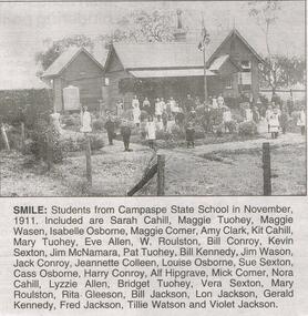
Bendigo Advertiser "The way we were" from Saturday, January 22, 2005. Smile: students from Campaspe State School in November 1911. Included are: Sarah Cahill, Maggie Tuohey, Maggie Wasen, Isabelle Osborne, Maggie Comer, Amy Clark, Kit Cahill, Mary Tuohey, Eve Allen, W. Roulston, Bill Conroy, Kevin Sexton, Jim McNamara, Pat Tuohey, Bill Kennedy, Jim Wason, Jack Conroy, Jeanette Colleen, Louise Osborne, Sue Sexton, Cass Osborne, Harry Conroy, Alf Hipgrave, Mick Comer, Nora Cahill, Lyzzie Alleen, Bridget Tuohey, Vera Sexton, Mary Roulton, Rita Gleeson, Bill Jackson, Lon Jackson, Gerald Kennedy, Fred Jackson, Tillie Watson and Violet Jackson. The clip is in a folder.newspaper, bendigo advertiser, the way we were -
 Victorian Aboriginal Corporation for Languages
Book, A month in the bush of Australia : journal of one of a party of gentlemen who recently travelled from Sydney to Port Philip : with some remarks on the present state of the farming establishments and society in the settled parts of the Argyle Country, 1965
Journal of a party of gentlemen travelling from Sydney to Port Phillip; p.6-7; Information on Lakes Bathurst &? George; p.15; Family, Yass area gathering &? eating manna; p.20; Meeting with small tribe Mantons Station; p.23-24; Hume R., tribe, guide Baambargan; p.26; Meeting with native party 27 miles S.E. Ovens R.; p.30-32; Catching possum Violet Creek, Aboriginal - English, flies warn game of danger, finding honey; p.38; Visit to camp Campaspe R.; p.41-42; Yarrayarre R. natives seen, attempts by guide to obtain wife, language difficulties; p.46; Head of Wearidy R. camp visited by natives.7colonisation, frontier life, pioneer life -
 Bendigo Historical Society Inc.
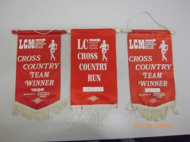
Banner - GOLDEN SQUARE P.S. LAUREL ST. 1189 COLLECTION: SPORTS FLAGS
Collection of sporting flags: 11 Loddon, Campaspe Mallee cross country; Team Winner 1989, red, 11 year old girls 2005, Team Winner Year Unknown; 8 years boys open 1995, 10 years girls 1995, Laurel street; 12/13 years boys 2003, 8 years old girls 2005, 9 years old boys, 12/13year boys 2000, 12/13 year girls 2000; 1Primary Schools basketball championship runners up 1996, 2 cricket team finalists, 1981-82, 1982-83; Team names provided; 3 BTCRSA Oakley winner flags, 1964, 1967 and 1969; Victorian Primary Schools' Sports Assn. Girls, Region runners up 1996.education, primary, golden square laurel st p.s. -
 Bendigo Historical Society Inc.
Document - Black and white laminated photo of flow of water from Lake Eppalock. 1964
John Perry Collection. Laminated copy of photo of crowd watching flow of water from the opened valve at the wall of Lake Eppalock during its commissioning. March, 1964. Lake Eppalock was created by flooding to town of Wild Duck. The dam was built by the State Rivers and Water Supply Commission of Victoria. The dam wall height is 45 metres (148 ft) and the main embankment is 1,041 metres (3,415 ft) long. At 100% capacity the dam wall was designed to hold back 304,651 megalitres (6.7014×10¹⁰ imp gal; 8.0480×10¹⁰ US gal) of water. The surface area of Lake Eppalock is 3,011 hectares (7,440 acres) and the catchment area is 2,124 square kilometres (820 sq mi). The controlled spillway is capable of discharging 8,040 cubic metres per second (284,000 cu ft/s). Lake Eppalock supplies both stock and domestic water to the Campaspe irrigation district. It also serves as a water supply to Bendigo and Heathcote and, in more recent times, Ballarat. The lake is a major attraction for those engaging in watersports, with a number of tourist parks and accommodation facilities available. Permissible activities on the lake include high-speed boating, water skiing, sailing, canoeing, fishing and swimming. The lake's water levels were low for approximately eight years between 2002 and 2010 during a prolonged drought, which restricted the amount of recreational activity until rainfall in the latter half of 2010 returned the lake to 100 percent capacity. Built between 1961 and 1964, Lake Eppalock remains the only water storage on the Campaspe River system.water, dam, reservoir, eppalock, wild duck -
 Bendigo Historical Society Inc.
Map - Map of Lake Eppalock shoreline when empty
John Perry Collection. Laminated copy of map detailing Lake Eppalock shoreline when empty. Circa 1951. Has colored highlighter lines following roads leading to lake shoreline and various inundated old roads and tracks on lakebed. The dam was built by the State Rivers and Water Supply Commission of Victoria. The dam wall height is 45 metres (148 ft) and the main embankment is 1,041 metres (3,415 ft) long. At 100% capacity the dam wall was designed to hold back 304,651 megalitres (6.7014×10¹⁰ imp gal; 8.0480×10¹⁰ US gal) of water. The surface area of Lake Eppalock is 3,011 hectares (7,440 acres) and the catchment area is 2,124 square kilometres (820 sq mi). The controlled spillway is capable of discharging 8,040 cubic metres per second (284,000 cu ft/s). Lake Eppalock supplies both stock and domestic water to the Campaspe irrigation district. It also serves as a water supply to Bendigo and Heathcote and, in more recent times, Ballarat. The lake is a major attraction for those engaging in watersports, with a number of tourist parks and accommodation facilities available. Permissible activities on the lake include high-speed boating, water skiing, sailing, canoeing, fishing and swimming. The lake's water levels were low for approximately eight years between 2002 and 2010 during a prolonged drought, which restricted the amount of recreational activity until rainfall in the latter half of 2010 returned the lake to 100 percent capacity. Built between 1961 and 1964, Lake Eppalock remains the only water storage on the Campaspe River system.map, eppalock, reservoir, lake, water -
 Bendigo Historical Society Inc.
Document - Directions to Lake Eppalock with road descriptions and map
John Perry Collection. Laminated copy of 'Directions to Lake Eppalock'. Gives directions in relationship of Lake Eppalock to Bendigo, Kyneton and Heathcote. Undated. Gives basic descriptions of bridges on lakebed, ford crossings on lakebed and inundated dwellings on lakebed. The dam was built by the State Rivers and Water Supply Commission of Victoria. The dam wall height is 45 metres (148 ft) and the main embankment is 1,041 metres (3,415 ft) long. At 100% capacity the dam wall was designed to hold back 304,651 megalitres (6.7014×10¹⁰ imp gal; 8.0480×10¹⁰ US gal) of water. The surface area of Lake Eppalock is 3,011 hectares (7,440 acres) and the catchment area is 2,124 square kilometres (820 sq mi). The controlled spillway is capable of discharging 8,040 cubic metres per second (284,000 cu ft/s). Lake Eppalock supplies both stock and domestic water to the Campaspe irrigation district. It also serves as a water supply to Bendigo and Heathcote and, in more recent times, Ballarat. The lake is a major attraction for those engaging in watersports, with a number of tourist parks and accommodation facilities available. Permissible activities on the lake include high-speed boating, water skiing, sailing, canoeing, fishing and swimming. The lake's water levels were low for approximately eight years between 2002 and 2010 during a prolonged drought, which restricted the amount of recreational activity until rainfall in the latter half of 2010 returned the lake to 100 percent capacity. Built between 1961 and 1964, Lake Eppalock remains the only water storage on the Campaspe River system.water, dam, directions, eppalock -
 Federation University Historical Collection
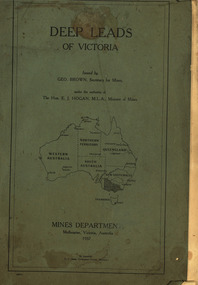
Book, Mines Department, Victoria, Deep Leads of Victoria, 1937, 1937
Charcoal green soft covered book of 64 pages. Contents include Ballarat, berry Consols, Canadian Lead, Castlemaine-Daylesford System, Chiltern, Duke of Cornwall Mine, Dyke's Freehold, Frenchman's Lead, Garibaldi Shaft, Glenfine, Guidlford, Hepburn Estate Co., Hepburn Home Paddock, Italian Gully, Henderson's Lead, Langi Logan, Leigh Consols, Sebastopol Plateau; Talbot, Woady Yalloak, A definition of a deep lead, formation of deep leads, water in deep leads, methods of deep lead mining (Tunnelling, Deep sinking, Chiltern method of working, Ballarat method of working), sampling washdirt and gravels, Balmoral, Mt William, Stawell, Moyston, Great Western, Ararat, Raglan, Wimmera Valley, Landsborough, Cardigan, Haddon, Beaufort, Waterloo, Avoca, Lamplough, Caralulup, Ballarat West, Ballarat, Smythesdale, Glenfine, Illabarook, Durham Lead, Morrison's Lead, Bullengarook, Berry-Moolort-Loddon System, Clunes, Creswick, Spring Hill, Bullarook, Castlemaine - Daylesford, Majorca, Carisbrook, Timor, Burnt Creek Tributary, Tarnagulla, Marong, Rheola, Inglewood, Huntly, Coliban, Campaspe, Goulburn Lead System, Ovens Valley System, Mitta Mitts, Kiewa Valley, Tarago, Tanjil, Moondarra, Bogong, Dargo High Plains, glossarymining, deep leads, mines department, squire, leigh consols, chiltern, duke of cornwall mine, dyke's freehold, frenchman's lead, garibaldi shaft, glenfine, guidlford, hepburn estate co., hepburn home paddock, italian gully, henderson's lead, langi logan, sebastopol plateau, talbot, woady yalloak, tunnelling, deep sinking, chiltern method of working, ballarat method of working, sampling washdirt. gravels, balmoral, mt william, stawell, moyston, great western, ararat, raglan, wimmera valley, landsborough, cardigan, haddon, beaufort, waterloo, avoca, lamplough, caralulup, ballarat west, ballarat, smythesdale, illabarook, durham lead, morrison's lead, bullengarook, berry-moolort-loddon system, clunes, creswick, spring hill, bullarook, castlemaine - daylesford, majorca, carisbrook, timor, burnt creek tributary, tarnagulla, marong, rheola, inglewood, huntly, coliban, campaspe, goulburn lead system, ovens valley system, mitta mitta, kiewa valley, tarago, tanjil, moondarra, bogong, dargo high plains -
 Bendigo Historical Society Inc.
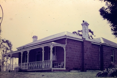
Slide - Adelaide Vale Homestead Fosterville
Adelaide Vale Homestead was begun in 1853 by John Harvey and was later occupied by Edward and Andrew O'Keefe. The building comprises a series of single storey stone buildings arranged behind a simple composed, verandah facade with a centrally located doorway flanked by windows. A central corridor leads from this doorway to a transverse corridor which was probably once an open breezeway. A free- standing octagonal pavilion is located close to the house. This is an interesting homestead dating from early times and constructed of local stone. The front facade is typically composed and the plan reflects the continuous growth of the property throughout the nineteenth century. The octagonal pavillion is a significant and unusual feature. The homestead is picturesquely sited and overlooks the Campaspe River valley, the Burke and Wills expedition camped nearby on their ill-fated expedition north. The old cheese factory is the sole survivor of the once extensive out-buildings. Some of the nineteenth century buildings have been demolished and there have been some later additions and alterations, notably an extensive side wing added in the 1920's. [In Butcher & Flanders, Bendigo Historic Buildings, 1987, the date of the house is given as 1868. Presumably this house replaced an older one on the property.]Adelaide Vale Homestead Fostervillehistory, bendigo, national trust collection bendigo, adelaide vale homestead -
 Bendigo Historical Society Inc.
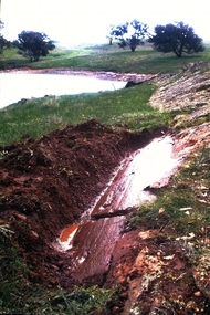
Slide - Dunn's Rock Eppalock, 2012
The low rolling hills of the Kimbolton countryside consist of ancient, hard and fractured Ordovician rock up to 65 million years old, which was originally deposited deep under the sea. Rocks mainly are sandstone, mudstone, black shale and quartz conglomerates. Marine fossils can be found in the area. Around seven million years ago a basalt flow buried the original bedrock along the along the Campaspe River. Ongoing weathering, wind and water movement over the following years has produced younger clay, sand, silt and gravel deposits throughout the area. Patches of White Hills Gravel are also found in the area. Another unique geological feature of this area is the Permian Glacial Pavement rocks north and south of Eppalock and glacial sediments (such as “Dunn’s Rock” and “Kellams Rock”). During the ice age (up to 280 million years ago) large glaciers moving over the countryside, scoured out sediments, pulverized bedrock, polished and cut grooves into bedrock in the direction of ice movement. When the ice melted boulders etc where left behind in areas of entirely different rock types, such as a 100 Tonne granite block known as ‘The Stranger’ near Derrinal. Dunn's Rock (Glaciated Pavement) Eppalock - Photos of the rock and a field group collecting date with Lake Eppalock (Knowsley) in the backgroundhistory, bendigo, dunn's rock eppalock, kimbolton forest, lake eppalock, gately collection -
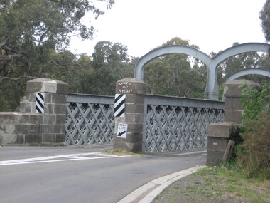 Ballarat Heritage Services
Photograph, Redesdale Bridge, 2016, 18/01/2016
The Redesdale Bridge is a wrought iron and timber structure with bluestone abutments which was installed over the Campaspe River in January 1868, although the bridge actually bears the date 1867. In 1859, the "Herald of the Morning", a ship carrying a cargo including 350 tons of ironwork for the Hawthorn bridge, caught fire and was scuttled a quarter of a mile off the jetty at Sandridge. A Melbourne salvaging firm raised the ironwork from the bottom of the bay, but after details of an arranged sale to the government caused a scandal in Parliament, the material was sold privately to the Melbourne foundry Langlands & Co. Two hundred tons of it was sold to the goldfields shires of McIvor and Metcalfe for only £1000. The bridge was designed by engineer T.B. Muntz and built by a contractor named Doran, and was completed late and considerably over budget at £6274. The bridge spans 45.7m across the river and has two roadways which are carried between three metal lattice girders in a through truss configuration. The design for the Hawthorn bridge had the deck supported over the trusses, and to stiffen the through truss configuration three sets of distinctive paired arches connect the trusses above the roadways. The roadway decking is constructed of longitudinally placed timbers on timber cross girders which rest on the lower chords of the trusses. (Heritage Victoria) A number of colour photographs showing the historic bridge at Metcalfe.metcalfe, shire of metcalfe, bridge, municipal boundary, shire of mcivor, redesdale bridge, campaspe river, t.b. muntz, doran -
 Freemasons Victoria - Southern Cross Lodge No. 24 (Maldon)
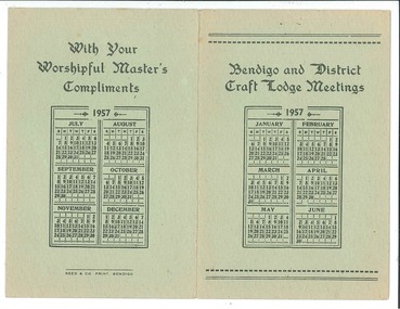
Meeting Card, Reed and Co. Print, 1957 Bendigo and District Craft Lodge Meetings, 1957
Offset Printed bi-fold card with lodge meetings in Bendigo Districtgolden & corinthian, mount alexander, mount franklin - st. george, mackenzie, st. george, southern cross, zetland, heathcote, aurora, zenith, eaglehawk, st. johns, rochester, trentham, kyneton, sadhurst, corona, wedderburn, gisborne, campaspe, carisbrook, harcourt, bendigo city -
 Bendigo Historical Society Inc.
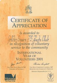
Document - GOLDEN SQUARE PRIMARY SCHOOL COLLECTION: CERTFICATES OF APPRECIATION
42 Certificates of appreciation/participation awarded to Golden Square Primary School Parents' Club, students and teachers. Awards from International Year of Volunteers 2001; Loddon Campaspe Multicultural Services; Bendigo RSL; Indigenous Literacy Foundation; jeans for Genes; Generals Basketball Club; Melbourne City Mission; Anti-Cancer Council; Juvenile Diabetes Research Foundation; MS Readathon, State Schools Relief Committee; Clean up Australia; Family Support Services, Parents Victoria; Good Friday appeal; Victoria Police Historical Society; Jump rope for Heart; Safety House Committee; Starlight foundation; City of Greater Bendigo Olympic Torch Relay; Camp Quality; Zone Football Carnival, School's Garden Awards; Heart Foundation; Target; Scholastic Book Club; School Industry Partnership Project; Royal Flying Doctor Service; Juvenile Diabetes Foundation; McDonald Camp Quality Puppets; Neighbourhood Watch; Centenary of Federation medallion certificate; Derby Hill Camp.bendigo, education, golden square primary school -
 Port of Echuca
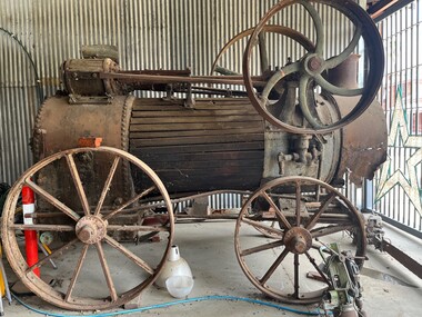
Functional object - Boiler engine, 1927
This is the Ruston and Proctor engine and boiler from the PS Little Wonder built by R Barbour, Cornella NSW. It was launched in December 1878. Owned by Murray River Sawmills, it was used for logging operations until 1904, when the vessel was dismantled. The engine and boiler was purchased by the Robins family and ran a pump on their property by the Goulburn River. The boiler was later condemned by the engine continued to be used with steam supplied by another boiler up until the 1950s. Now considered to be beyond repair. A good example of the technology and industrial history of northern Victoria and along the Goulburn River. boiler, steam display, steam garage, ruston and proctor -
 Port of Echuca
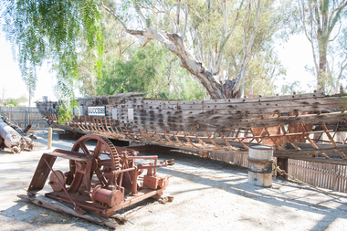
Functional object - Paddlesteamer hull, Westgood & Air, P.S Success, 1877
The PS Success was built in Moama in June 1977 by GB Air for Westwood & Air. It was built to tow barges of cargo along the Darling and Murray rivers, as well as running as a passenger boat from Swan Hill to Mildura during 1915-16. The Success was the last paddlesteamer actively working on the river when she performed several rescue voyages to flood bound properties along on the Darling River, rescuing sheep and a large cargo of wool. The vessel ended her working life in 1957 and was put up on the bank at Ned's corner, 80km west of Mildura. In 1996, the Pollard family donated the vessel to the Riverboat Historical and Preservation Society of Mildura with plans to restore her to her former glory. This project became increasingly difficult for the dedicated volunteers to handle and the Port of Echuca took ownership in 2009 in the hopes that further restoration work can be done at the Port. The Succes is currently on static display at the northern end of the Port of Echuca. The PS Success had a long, colourful history towing barges on the Murray River and in particular in the Mildura, Wentworth and Ned's Corner regions. She was the last paddlesteamer to be working on the river system right up until the 1956 floods towing the barge Vega, where at one point both boat and barge smashed into trees on a wild, uncontrolled journey downstream where she was damaged and later lay stranded on Ned's Corner.Composite timber hull, 3-inch red gum planks on angle iron frames. Carvel built with counter stern and straight stem. Originally had a round keel and a pair of 35hp engines. Success paddle steamers, echuca boat builders, westwood & air, p.s. success -
 Port of Echuca
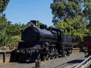
Functional object - A2 996 Locomotive, 1916
The A2 class was an express passenger locomotive that ran on Victorian Railways from 1907 to 1963. The 996 arrived at the Port of Echuca in 1968 from Newport and was donated to the City of Echuca by the Echuca Lions Club & the Rotary Club who had purchased it for 1250 pounds. the A2 996 is displayed at the Echuca Wharf Railway Siding.A2 996 is one of the later batch of sixty A2 class express passenger locomotives built with superheating and other design enhancements including Walschaerts valve gear. it was constructed at Newport Workshops in 1916 and was among the last few A2 class remaining in service when taken off register by the Victorian Railways in November 1963. Steam Locomotive made of steel & wrought iron with black livery. Front- A2 996 /. Rear - 996a2 locomotive, echuca lions club/rotary club, wharf, echuca loco shed, shire of campaspe, newport workshop, rollingstock collection, steam trains -
 Port of Echuca
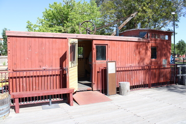
Functional object - Brake Van (Guards Van), 1914
Standard Victorian Railways Brake Van (Guards Van) originally Z 448 built at Newport Workshops & body built by Grimmond & Party butty gang. Entered traffic on 23rd March 1914. Altered to ZL448 incorporating long travel draft gear, 28th November 1961. Off Register on 10th August 1982 & sold to Echuca City Council 3rd September 1982 This is an example of the most numerous type of brake van used by Victorian Railways over a very long period. Brake vans would not have been a common sight at the Wharf as the line to the Wharf was operated as a siding from Echuca Station, so a brake van was not required. It is possible that a shunter walked ahead of the train to and from the wharf. This vehicle is significant. However a large number survive in operable condition around Victoria. Standard Vic Rail Brake (Guards) Van. wharf, shire of campaspe, newport workshop, brake van, grimmond & party butty gang, guards van, rollingstock collection, steam trains