Showing 173 items matching "channel islands"
-
 Lakes Entrance Historical Society
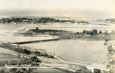
Photograph, Eastwood Bros, 1889c
Sepia photograph showing the just opened Entrance to Bass Strait. Sand not completely cleared from channel, buildings on dunes, dredge Wombat moored off Bullock Island. Rock groynes being built in lake. Lakes Entrance Victoriawaterways, islands, jetties, houses -
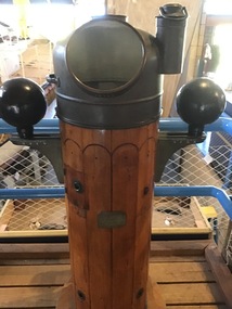 Queenscliffe Maritime Museum
Instrument - Binnacle Compass
Built in 1914 by Fleming and Ferguson in Paisley Scotland as Sir William Matthews for the Ceylon Government, she was a twin screwed steam bucket dredge. She was purchased from the Western Australian Government by the Melbourne Harbour Trust on 10 October 1941. After an extensive overhaul, the vessel was renamed the George Kermode and commenced operation in Victorian waters on 22 June 1942. The George Kermode was scuttled by the Department of Conservation, Forests and Land off Phillip Island on the 1 April 1976 as part of an artificial reef program. This vessel was used to dredge the Port Phillip channels from 1942 and is of cultural significance to Queenscliffe.Binnacle compass from the 'George Kermode'Compass No. 3127N Sestrel Type 89098bucket dredge, port phillip, melbourne harbour trust -
 Phillip Island Conservation Society Inc.
Work on paper - Photocopy of newspaper cutting, "PENGU/ CHOK/ IN/ OIL" (meant to be : "Penguins choke in oil"
With the establishment of the large heavy industrial zone at Hastings in the late 1960s, which included the BP oil refinery using the Port of Hastings at the north-western arm of Western Port, a number of environmental problems predicted by both scientists and conservationists arose. The main shipping channel on the western arm of Western Port was dredged, causing suspended particles affecting seagrass beds. With inadequate regulation around discharge of bilge water within the bay, and oil spillage, oil pollution affecting both seabirds and coastal areas was not uncommon. This report of 40 penguins actually known to have been killed by an oil spill event was typical of reports at the time. The 2 men quoted – Vernon Johnson and Ken Pound – were well known conservationists. Vernon and his wife Nora owned the Kingston Gardens picnic and zoo business where they cared for many injured wildlife. Ken was a Phillip Island counsellor for a few years, and instrumental in the establishment of the Phillip Island conservation Society. He also contributed various documents and newspaper cuttings to this archive.This article is significant for being a record of an exact number of penguins found dead from oil spill pollution in Western Port. Also as a record of conservationists in the early years of community and environment movements both locally and in Australia. The article further gives evidence of linking tourism with wildlife.Photocopy of newspaper cutting. Black print with very dark black and white photo of Fairy (Little) Penguin. Poor reproduction due to older photocopy machine.(indecipherable) - late/1960s.little penguins, fairy penguins, eudyptula minor, penguin behaviour, phillip island tourist attractions, phillip island conservation society, oil spills, bp refinery hastings, port of hastings, western port, marine pollution, oil tankers, vernon johnson, ken pound, phillip island promotion association -
 City of Kingston
Photograph - Black and white, 20 December 1945
... the Channel Island of Guernsey, bought two acres of land ...Cheltenham is a suburb in the City of Kingston that was originally established as a rural market gardening community. The area is bordered by Highett, Mentone and Heatherton. The market gardens, farms and paddocks have gradually been sub-divided into housing and industrial estates. The Southland shopping centre is a major feature of the area.Cheltenham was established as a rural market gardening community. The Le Page family lived in Cheltenham since 1854 when Nicholas Le Page, a tailor from the Channel Island of Guernsey, bought two acres of land on Chesterville Road near Bernard Street to establish a market garden. Over the years the Le Pages purchased more land in the area. In 1875-76 Nicholas' son Frank and his wife Mary built 'Daphne Cottage' near the corner of Bernard and Wilson Streets. n the 1940s Frank's son, Everest Le Page, bought five more lots of land in Chesterville Road from the Tuck family. The Le Pages grazed horses, ponies and cows on this land, and grew pumpkins, carrots, parsnips, onions, potatoes and cabbages. Many buildings and locations within in Cheltenham commemorate the Le Page family's contribution to the Cheltenham community.Aerial photograph taken in 1945 of the Cheltenham district within the City of Kingston. The image includes Chesterville Road, the future site of Turner Road pool (now Waves) and Highett Reserve, (top left), Jellicoe Street, Argus Street, Bernard Street, Wilson Street, the Methodist Children Homes (now Southland), McIvor Street, Goulburn Street, Nepean Highway, Jamieson Street and Barker Street (bottom left), market gardens and paddocks. In the top centre of the image, "Daphne Cottage", the home of Frank T. Le Page is visible on the corner of Bernard and Wilson Streets. Much of the land depicted in this image was owned by the Le Page family. This image is possibly from the collection of aerial photographs commissioned by the Department of Crown Lands and Survey and taken by Adastra Airways.Black and white ink: 57250 White print: VIC-170 57250 20.12.45 Run 6 PROJ. No. 5 MELB. METROP AREA Black type 10200 FTS 30' LENS 20.12.45cheltenham, market gardens, industry, le page family -
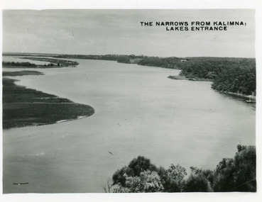
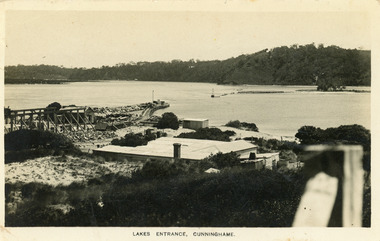 Lakes Entrance Historical Society
Postcard - New Works, Bulmer H D, 1910c
Also second copy same sizeBlack and white postcard showing view of Works buildings and north end of eastern pier. Cunninghame Arm and tip of Bullock Island and groyne work on right. Reeves channel and tip of Rigby Island on left. Mt Barkly and Kalimna Hills in background. Photo taken from top of dune. Roof of Carstairs boarding house centre foreground. Lakes Entrance VictoriaLakes Entrance, Cunninghamewaterways, settlement, historic buildings -
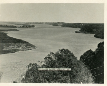 Lakes Entrance Historical Society
Postcard - Reeves Channel, Valentine Series, 1930c
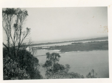
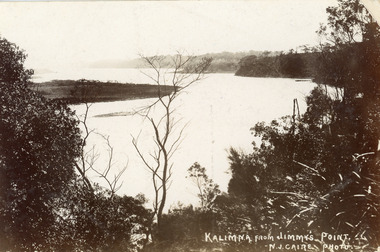
Other copy similar view with inscription 'The Lakes, Lakes Entrance Vic'Black and white postcard of Reeves Channel Gippsland Lakes, showing Rigby, Fraser and Flannagan Islands opposite the steep shoreline of the mainland. Natural vegetation of Jemmys Point in foreground from which photograph was taken. Lakes Entrance VictoriaKalimna from Jemmys Point Lakes Entranceislands, waterways, topography -
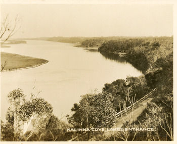 Lakes Entrance Historical Society
Postcard - Reeves Channel, Valentine Series, 1930c
Black and white small format postcard of Reeves Channel Gippsland Lakes, taken from Jemmys Point. It shows a glimpse of the Princes Highway, the steep shoreline of the mainland opposite Rigby Island with Fraser Island and Flannagan Island in distance. Lakes Entrance VictoriaKalimna Cove Lakes Entranceislands, waterways, topography -
 Lakes Entrance Historical Society
Postcard - Reeves Channel, 1930c
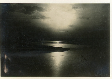
3 identical 6 x 8.5|1 same size hand tinted 6 x 8.5Black and white small format postcard of a sunset scene on Reeves Channel, Gippsland Lakes. It shows sunlight reflected through clouds and on the lake between Rigby Island and the mainland. Lakes Entrance Victoriaislands, waterways, topography -
 Lakes Entrance Historical Society
Photograph - Rigby Island, 1930c
Second copy similar viewBlack and white photograph of Rigby Island, Gippsland Lakes Victoria. It shows Reeves Channel on right of photo, Hopetoun Channel on left, The Narrows below Jemmys Point from which photo was taken. Lakes Entrance Victoriaislands, waterways, topography -
 Lakes Entrance Historical Society
Postcard - Reeves Channel, Bulmer H D, 1930c
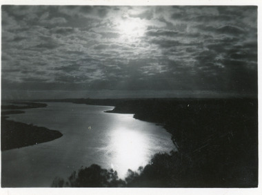
Second copy 5.5 x 8.5Black and white large format postcard showing moonlight reflections through clouds and across Reeves Channel of Lake King, Gippsland Lakes. Dark form of Rigby Island breaks the reflection on the lake. Lakes Entrance VictoriaMoonlight from Jemmys Point Lakes Entranceislands, waterways -
 Lakes Entrance Historical Society
Photograph - Lake King, Tambo Shire, 1995c
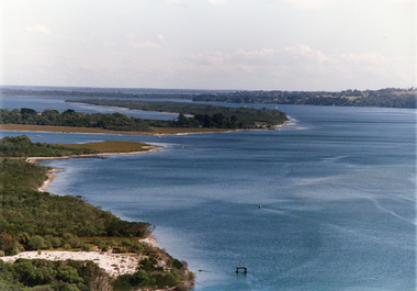
... , and Flannagan Island, and Reeves Channel of Lake King, Gippsland Lakes... Island, and Reeves Channel of Lake King, Gippsland Lakes. Steep ...Also second copyColour photograph of portion of Rigby Island, Fraser Island, and Flannagan Island, and Reeves Channel of Lake King, Gippsland Lakes. Steep shore of mainland in distance. Lakes Entrance Victoriaislands, waterways, topography -
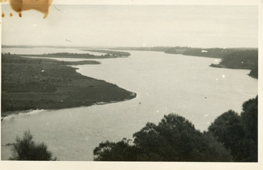
 Lakes Entrance Historical Society
Postcard - The Narrows, Bulmer H D, 1945c
Also two other copies 6.5 x 8.5Black and white small format postcard of the Narrows, and Reeves Channel of Lake King, Gippsland Lakes, showing Rigby, Fraser and Flannagan Islands opposite the steep shoreline of the mainland. Taken from Jemmys Point. Lakes Entrance VictoriaThe Narrows from Kalimna Lakes Entranceislands, waterways -
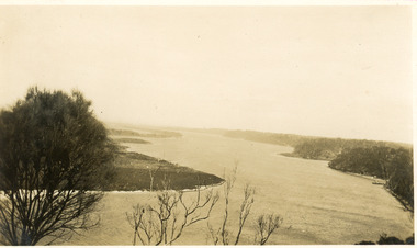
 Lakes Entrance Historical Society
Photograph - Lake King, 1950c
Also copy of same view, stained, 9 x 14Black and white photograph of the Narrows and Reeves Channel of Lake King, Gippsland Lakes. It shows Rigby, Fraser, and Flannagan Islands opposite the steep shoreline of the mainland. Taken from Jemmy's Point, it shows a recently built groyne from Rigby Island into the Narrows. Lakes Entrance Victoriaislands, waterways, topography -
 Lakes Entrance Historical Society
Photograph - Reeves Channel, 1930c
Black and white photograph of Reeves Channel on Lake King, Gippsland Lakes. It shows part of Rigby Island opposite the steep mainland shore of the lake. Lakes Entrance Victoriaislands, waterways, topography -
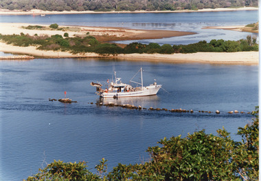 Lakes Entrance Historical Society
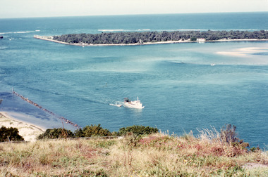
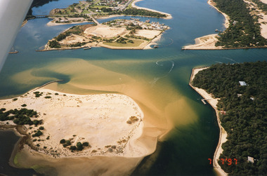
Photograph - Dredging, Tambo Shire, 1990c
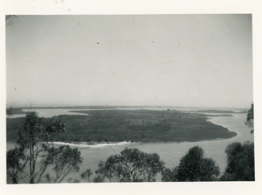
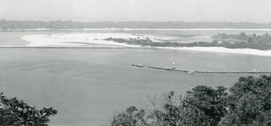
Second copyColour photograph of the south eastern shore of Rigby Island, Gippsland Lakes. It shows the scrub covered hummocks in the background, Hopetoun Channel, dumped sand which connects Snake Island and Rigby Islands, groynes into Narrows from Rigby Island. Fishing boat with scallop dredge moored in sheltered bay inside a groyne. Lakes Entrance Victoria waterways, topography, fishing industry, dredging -
 Lakes Entrance Historical Society
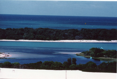
Photograph - Reeves Channel, Fraser, Ian, 1995c
Colour photograph of Reeves Channel of Lake King, Gippsland Lakes. It shows part of both Rigby Island and Fraser Island opposite the steep shoreline of the mainland. Two motor boats on lake. Lakes Entrance Victoriaislands, waterways, topography -
 Lakes Entrance Historical Society
Photograph - The Entrance, Fraser, Ian, 1990c
Colour photograph of the lake. It shows a fishing boat with scallop dredge moving up the lake opposite the artificial entrance, grassy edge of Jemmy's Point in foreground above highway guard fence, rock groyne at entry to North Arm, sandy shallows at entry to Hopetoun Channel, scrub covered hummocks of south shore and Bass Strait in distance. Lakes Entrance Victoriaislands, waterways, topography -
 Lakes Entrance Historical Society
Photograph - Hopetoun Channel, Fraser, Ian, 1996c
Colour photograph of Bass Strait, scrub covered coastal dunes, Hopetoun Channel, and southern portion of Rigby Island. Photo taken from sand dunes on Flannagan Island, near Lakes Entrance, Victoria.islands, waterways, topography -
 Lakes Entrance Historical Society
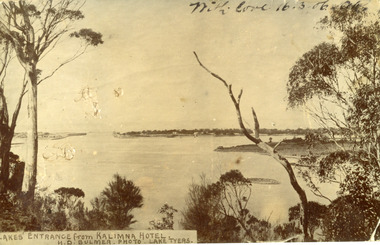
Postcard - The Entrance
Black and white post card showing the man made entrance through the hummock. It shows the fishermen's cottages on the western side of the entrance, Rigby Island and the Doughboy, small island, with salt affected vegetation and a small sand bar in the channel. Natural vegetation of Kalimna cliff in foreground. Lakes Entrance VictoriaLakes Entrance from Kalimna Hotel waterways, topography -
 Lakes Entrance Historical Society
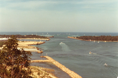
Photograph - The Entrance, Holding George, 1979
... Colour photograph of the Entrance, Bullock Island... Colour photograph of the Entrance, Bullock Island and Reeves ...Date made April 1979Colour photograph of the Entrance, Bullock Island and Reeves Channel, taken from Jemmys Point during the King of the Straits, offshore powerboat race. It also shows the built up groynes at the entrance to the North Arm, Pecks fish processing factory seen on Bullock Island. Lakes Entrance Victoriawaterways, recreation, boats and boating -
 Lakes Entrance Historical Society
Photograph - The Entrance, 1979
... Colour photograph of the entrance, Bullock Island... photograph of the entrance, Bullock Island and Reeves Channel. Taken ...The king of the straits, offshore powerboat race with Lakes entrance as a destination was not repeated due to adverse weather conditionsColour photograph of the entrance, Bullock Island and Reeves Channel. Taken from Jemmys Point during the King of the Strait offshore powerboat race. It also shows the built up groynes at the entrance to the North Arm. Lakes Entrance Victoriafishing industry, waterways, boats and boating -
 Lakes Entrance Historical Society
Photograph - Lakes Entrance, 1997
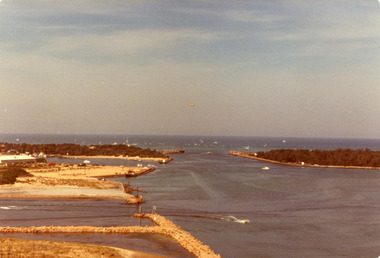
Date made 7 July 1997Colour photograph being an aerial view of entrance at Lakes Entrance, showing the sand hummocks, the sand bar offshore a fishing boat entering the channel through the bar which appears to be recently dredged township of Lakes Entrance Victoria waterways, islands, boats and boating -
 Lakes Entrance Historical Society
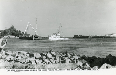
Postcard - Judith, The Rose Series
Black and white postcard taken from Bullock Island, showing the fishing boat Judith entering Cunninghame Arm from the entrance channel. Lakes Entrance VictoriaHeading for Home Fishing Trawler at the Entrance Lakes Entrancefishing industry, waterways, boats and boating -
 Lakes Entrance Historical Society
Postcard - Bullock Island, Bulmer H D, 1945
Black and white postcard of Bullock Island, Lakes Entrance, showing an extensive rock groyne to the south of the island, into which dredged sand and spoil is to be placed in order to extend the island's area. North Arm bridge, Bullock Island footbridge, New Works settlement and Entrance channel also in image. Lakes Entrance VictoriaBullock Island, Lakes Entranceboats and boating, fishing industry, islands -
 Lakes Entrance Historical Society
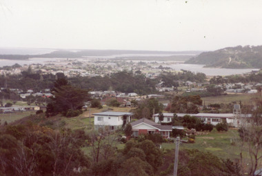
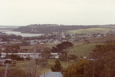
Photograph - Township, Fish, Marie, 1985c
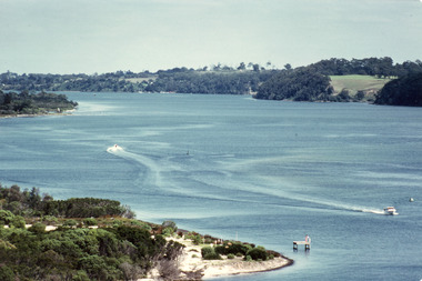
... Bullock Island and Rigby Island and Hopetoun Channel in centre... on left. Looking towards Bullock Island and Rigby Island ...\Colour photograph of township showing, North Arm and North Arm Bridge, Jemmys Point, Mount Barkly, Kalimna Heights on right, Cunninghame Arm and sand dunes on left. Looking towards Bullock Island and Rigby Island and Hopetoun Channel in centre background. Sea Vista flats in foreground. Photo take from near Telecom Tower on Merrangbaur Hill circa 1985. Lakes Entrance Victoria bridges, waterways, township -
 Lakes Entrance Historical Society
Photograph - Township, Fish, Marie, 1985c
... Bullock Island and Rigby Island and Hopetoun Channel in centre... on left. Looking towards Bullock Island and Rigby Island ...Colour photograph of township showing, North Arm and North Arm Bridge, Jemmys Point, Mount Barkly, Kalimna Heights on right, Cunninghame Arm and sand dunes on left. Looking towards Bullock Island and Rigby Island and Hopetoun Channel in centre background. Sea Vista flats in foreground. Photo take from near Telecom Tower on Merrangbaur Hill circa 1985. Lakes Entrance Victoria bridges, waterways, township -
 Mission to Seafarers Victoria
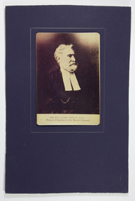
Photograph - Photograph, mounted, Reverend John Ashley, D.D. - Pioneer Chaplain in the Bristol Channel
Reverend John Ashley was a key initiator of missionary services to seafarers isolated and confined to moored ships or islands with families in the Bristol Channel of the 1830s. Attention was also focussed by other individuals, groups and churches in ports and led eventually to the establishment of the Mission to seamen, London which in turn inspired establishment of similar services in other countries and ports. Rev'd Kerr-Johnson who arrived in Australia was appointed by a Bethel Union of non-conformist churches in late 1856 and delivered the first shipboard service in 1857 for the Victorian Mission to seamen. refs: 1895-1905 Epitomised history... (MtsV) and Dr Ashley's Pleasure Yacht publication MTSV collection.John Ashley portraits are rare and this is the only image of him held in the collection at the Mission to Seafarers Melbourne. See also History for full significance.Sepia toned photograph of John Ashley mounted on dark blue card. Text at the bottom section of the photograph reads "THE REV.JOHN ASHLEY, D .D. /Pioneer Chaplain in the Bristol Channel"city of bristol, seamen's mission, mission to seamen, reverend john ashley (1801-1886) -
 Lakes Entrance Historical Society
Photograph - Snake Island, 1950c
Also two other copies 7 x 11Black and white photograph showing eastern end of Rigby Island, Snake Island, and dunes at Lakes Entrance, Victoria. Reeves River below, foreground bushes, Hopetoun Channel in middle distance, Bass Strait in distance. waterways, topography, islands -
 Lakes Entrance Historical Society
Photograph - Rigby Island, 1955c
Black and white photograph showing east end of Rigby Island, sand build up on Snake Island and rock groynes at Lakes Entrance, Victoria. Shrubbery in foreground, rock groynes in Reeves Channel, sand dunes in background.waterways, ocean, islands -
 Lakes Entrance Historical Society
Postcard - Reeves Channel, Caire Nicholas John, 1905c
Also black and white enlargement 16 x 25Black and white postcard of the lake below Jemmys Point, Gippsland Lakes, showing Rigby Island opposite the steep cliffs of Kalimna and Nungurner shores of lakes. Small island, known as the Doughboy of Rigby Island. View taken from Jemmys Point with natural vegetation in foreground. Lakes Entrance VictoriaKalimna from Jimmys Pointislands, waterways, topography, boats and boating