Showing 125 items
matching colonial bank
-
![Map, Liquidator's sale, 1896. [Woolpack Estate, Bacchus Marsh]](/media/collectors/5e461d8021ea67224c82f2a1/items/6779ee97032b72846b5995f2/item-media/6779ef33032b72846b599b30/item-fit-380x285.jpg) Bacchus Marsh & District Historical Society
Bacchus Marsh & District Historical SocietyMap, Liquidator's sale, 1896. [Woolpack Estate, Bacchus Marsh]
The Woolpack Estate was an area of land owned by various landowners in the Bacchus Marsh area since the early Colonial period of the 1840s. The area was located on the eastern side of the Bacchus Marsh township about 7 kilometers from the town. The Lerderderg River ran through part of the land and so did the Melbourne to Ballarat Road. The historic Woolpack Inn associated with James Crook was also located on this land. By 1896 150 acres of this land was under the control of liquidators for the Federal Bank of Australasia who instructed that the land be sub-divided and sold in lots by public auction. A successful sale was held on 24 June 1896. Most of the blocks of land were sold for higher than expected prices and most of the buyers were people from the town and district of Bacchus Marsh. The map includes various details about the land which is described on the map as an "important sale of rich alluvial irrigable flat land in the Bacchus Marsh Valley, and other properties". The auction was conducted by the local agents W. Anderson and Bence in conjunction with Pearce Brothers also of Bacchus Marsh.A single page paper map showing a plan of 150 acres of land from the Woolpack Estate to be sold in various lots in June 1896. Also shown on the map are lots for sale at Robinson's Farm on Coimadai Creek and allotments near Bacchus Marsh railway station, including lots on Government Road (East Maddingley Road), View Street and Government Road (Parwan Road). No scale provided. The map is pasted into a bound volume containing 76 maps or plans in total. High resolution digital image stored on BMDHS computer network. land sales bacchus marsh, bacchus marsh victoria maps, woolpack estate bacchus marsh victoria -
 Hymettus Cottage & Garden Ballarat
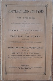
Work on paper - Book, Abstract and Analysis of the Evidence taken by A Select Committee of the Assembly of Victoria in the Case of George Dunmore Lang Late Manager and Frederic Lee Drake Late Assistant of the Bank of New South Wales at Ballaarat
Rev John Dunmore Lang's defence of his son who was imprisoned for his part in the fraud at the Bank of New South Wales Ballarat and Clunes in 1854.Small 95 page booklet published in 1857 by Fairfax, Melbourne and inscribed by W. D. Lang.non-fictionRev John Dunmore Lang's defence of his son who was imprisoned for his part in the fraud at the Bank of New South Wales Ballarat and Clunes in 1854.drake, lang, rev john dunmore lang, ballarat, clunes, select committee of enquiry -
 Kew Historical Society Inc
Work on paper - Sepia Wash & Ink, G B Richardson, Creek and Old Watering Stage, on the Yarra, East Collingwood, 1854, 1854
Blind Creek was located between the Abbotsford Convent and what is now the Collins Bridge in Studley Park. In an 1858 map of East Collingwood by Clement Hodgkinson, in the State Library of Victoria, one can see how the creek was originally a significant landmark in Collingwood; remaining vacant land until a barrel drain enclosed it. The area was later filled in, surveyed and developed. The position where Blind Creek entered the Yarra was in the immediate vicinity of Hodgson’s Punt, which had linked Kew to the other side of the Yarra from 1839. The Punt was purchased by the Colonial Government in 1852 and was in use until the opening of the Studley Park Road (Johnston Street) Bridge in 1858 made its continued use redundantThe point of view selected by the artist for the watercolour is from the banks of Blind Creek in East Collingwood, looking across the Yarra to the Kew side of the river.Inscribed verso 'Creek and Old Watering stage, on the Yarra East Collingwood 1854 / Trees, stage, &c have long since disappeared / [Artist Signature] / FT 110 / Creek itself now being filled in 1903.gb richardson, blind creek - abbotsford, yarra river - abbotsford (vic) - kew (vic), colonial artists, australian art - 19th century, george bouchier richardson -
 Stawell Historical Society Inc
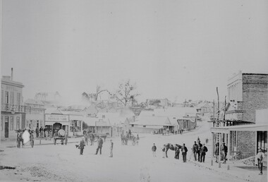
Photograph, Upper Main Street looking East from Patrick Street corner across Layzell Street 1866
Upper Main Street looking East. Poppet Heads in Background. Oriental Bank second on left then Quartz Reef Timber Yards. Intersection is Layzell St Main Street. Advertiser Office on right in front of Earlier Mechanics Institute. Part of a collection of Photographs by Mr. O.G. Armstrong as commissioned by the Shire of Stawell for the Inter-colonial and Paris Exhibition in Melbourne in 1866. View of the top end of Main Street 1866 with the Commercial Hotel in the left foreground. On the right is the Advertiser Newspaper office an Ararat newspaper before one was started in Stawell. The building on the right with the ladder in front was the Mechanics Institute later burned down twice. Upper Main street with Poppet Heads in the background, the Oriental Bank second on left & then Quartz Reef Timber Yard 1867. Lots of people and wagons in street. Advertiser Office on right and earlier Mechanics Institute with ladder at front.Upper Main Street Reefs 1867stawell mining streetscape -
 Stawell Historical Society Inc
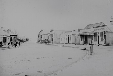
Photograph, Upper Main Street with the London Chartered Bank on the right, Mr W Muir Produce Dealer & the Bank of Victoria 1866
Main Street. On Right is London Chartered Bank. W Muir Produce Dealer. Bank of Victoria. Part of a collection of Photographs by Mr. O.G. Armstrong as commissioned by the Shire of Stawell for the Inter-colonial and Paris Exhibition in Melbourne in 1866. Another view of the top or eastern end of Main Street 1866. It is almost the same area as in photo No 14 but looking westward towards the Grampians. Streetscape with bend of road in foreground. Bank of Victoria prominent on right side of image.stawell businesses streetscape