Showing 140 items matching "connection to land"
-
 Eltham District Historical Society Inc
Photograph, Looking south across the Fitzsimons Lane Bridge over Yarra River between Eltham and Templestowe
The bridge over the Yarra River was initially opened September 22nd, 1961. Newspaper reports at the time of opening stated it linked Bolton Street, Eltham, with Fitzsimons Lane, Templestowe. In 1955 the Country Roads Board (CRB) produced survey plans that showed proposed land acquisition for the future bridge and road approaches. The 1955 plan shows that it was proposed to connect Fitzsimons Lane with Bolton Street in Eltham by a diagonal road across the river. The road connection would then continue along Bolton Street to Main Road. Prior to construction of the bridge the CRB modified the proposal significantly so that there was a new road parallel with Bolton Street and then curving to join Main Road at what was then its intersection with Old Eltham Road. This involved significantly more land acquisition and altered the pattern of land subdivision through this corridor. Initially the new road was just a single two-way carriageway as it would have required a significant widening of the cutting on the Shire of Eltham side of the river. The road was officially un-named but was known locally as the Eltham-Templestowe Road. The 1966 Melway street directory and other 1960s editions also listed the road as the Eltham-Templestowe Road. In December 1970, Eltham Shire Council, in pursuance of the provisions of the Local Government Act, named it Templestowe Road. The road was renamed Fitzsimons Lane around 1984 in conformity with the section south of the river. In 1991 a new bridge was built to the west of the original bridge. Fitzsimons Lane was widened to four traffic lanes although on the Eltham side this was done within the limits of the existing cutting. NEW BRIDGE STARTS THEM EXPLORING Without any fanfares, Country Roads Board workmen on Friday afternoon put the finishing touches to the approaches, removed the barricades, and let the traffic roll over the new Yarra bridge linking Bolton Street, Eltham, with Fitzsimons Lane, Templestowe. Over the week-end many “bridge watchers” who were making one of their periodic inspections of the progress on the new bridge found to their surprise that they could drive over it, so that people who had gone for a run out to Eltham suddenly found themselves wandering through Templestowe and Doncaster. By Monday the word of the bridge’s opening had got around sufficiently for many regular travellers to the city from Eltham and beyond to vary the monotony by going to town via Templestowe and Kew instead of through Heidelberg. They were surprised at the distances – about 3 ½ miles from Eltham to Templestowe, 6 miles from Eltham Shire hall to the Lower Heidelberg Road-Banksia Street intersection. NEW NEIGHBOURS For people on both sides of the river, the new bridge has turned distant friends into near neighbours. A Greensborough man on Sunday took 35 minutes to reach the home of a friend in East Doncaster, but the return trip over the new bridge took only 17 minutes. It will be some time yet before most people work out the possibilities in shorter and quicker trips form the north-eastern areas to the eastern and south-eastern suburbs. The coming of the warmer months will soon teach many, though the short cuts to Peninsular beaches and eastern suburban drive-ins. And before very long it is likely there will be a Tramways bus running from Templestowe to Eltham station. NEW BRIDGE STARTS THEM EXPLORING (1961, September 27). The Diamond Valley News (News clipping held in SEA_74-1_047) The previously un-named road between Main Road and Yarra River, Eltham South, east of Bolton Street was named Templestowe Road, December 15, 1970 NAMING OF STREETS AND ROADS. (1970, December 15). The Diamond Valley News (News clipping held in SEA_74-2_022)Black and white photographinfrastructure, shire of eltham infrastructure, bridge, fitzsimons lane bridge, yarra river -
 Eltham District Historical Society Inc
Photograph, Fitzsimons Lane Bridge over Yarra River between Eltham and Templestowe
The bridge over the Yarra River was initially opened September 22nd, 1961. Newspaper reports at the time of opening stated it linked Bolton Street, Eltham, with Fitzsimons Lane, Templestowe. In 1955 the Country Roads Board (CRB) produced survey plans that showed proposed land acquisition for the future bridge and road approaches. The 1955 plan shows that it was proposed to connect Fitzsimons Lane with Bolton Street in Eltham by a diagonal road across the river. The road connection would then continue along Bolton Street to Main Road. Prior to construction of the bridge the CRB modified the proposal significantly so that there was a new road parallel with Bolton Street and then curving to join Main Road at what was then its intersection with Old Eltham Road. This involved significantly more land acquisition and altered the pattern of land subdivision through this corridor. Initially the new road was just a single two-way carriageway as it would have required a significant widening of the cutting on the Shire of Eltham side of the river. The road was officially un-named but was known locally as the Eltham-Templestowe Road. The 1966 Melway street directory and other 1960s editions also listed the road as the Eltham-Templestowe Road. In December 1970, Eltham Shire Council, in pursuance of the provisions of the Local Government Act, named it Templestowe Road. The road was renamed Fitzsimons Lane around 1984 in conformity with the section south of the river. In 1991 a new bridge was built to the west of the original bridge. Fitzsimons Lane was widened to four traffic lanes although on the Eltham side this was done within the limits of the existing cutting. NEW BRIDGE STARTS THEM EXPLORING Without any fanfares, Country Roads Board workmen on Friday afternoon put the finishing touches to the approaches, removed the barricades, and let the traffic roll over the new Yarra bridge linking Bolton Street, Eltham, with Fitzsimons Lane, Templestowe. Over the week-end many “bridge watchers” who were making one of their periodic inspections of the progress on the new bridge found to their surprise that they could drive over it, so that people who had gone for a run out to Eltham suddenly found themselves wandering through Templestowe and Doncaster. By Monday the word of the bridge’s opening had got around sufficiently for many regular travellers to the city from Eltham and beyond to vary the monotony by going to town via Templestowe and Kew instead of through Heidelberg. They were surprised at the distances – about 3 ½ miles from Eltham to Templestowe, 6 miles from Eltham Shire hall to the Lower Heidelberg Road-Banksia Street intersection. NEW NEIGHBOURS For people on both sides of the river, the new bridge has turned distant friends into near neighbours. A Greensborough man on Sunday took 35 minutes to reach the home of a friend in East Doncaster, but the return trip over the new bridge took only 17 minutes. It will be some time yet before most people work out the possibilities in shorter and quicker trips form the north-eastern areas to the eastern and south-eastern suburbs. The coming of the warmer months will soon teach many, though the short cuts to Peninsular beaches and eastern suburban drive-ins. And before very long it is likely there will be a Tramways bus running from Templestowe to Eltham station. NEW BRIDGE STARTS THEM EXPLORING (1961, September 27). The Diamond Valley News (News clipping held in SEA_74-1_047) The previously un-named road between Main Road and Yarra River, Eltham South, east of Bolton Street was named Templestowe Road, December 15, 1970 NAMING OF STREETS AND ROADS. (1970, December 15). The Diamond Valley News (News clipping held in SEA_74-2_022)Black and white photographinfrastructure, shire of eltham infrastructure, bridge, fitzsimons lane bridge, yarra river -
 Eltham District Historical Society Inc
Photograph, Russell Yeoman, Fitzsimons Lane Bridge over Yarra River between Eltham and Templestowe, c.1970, 1970c
The bridge over the Yarra River was initially opened September 22nd, 1961. Newspaper reports at the time of opening stated it linked Bolton Street, Eltham, with Fitzsimons Lane, Templestowe. In 1955 the Country Roads Board (CRB) produced survey plans that showed proposed land acquisition for the future bridge and road approaches. The 1955 plan shows that it was proposed to connect Fitzsimons Lane with Bolton Street in Eltham by a diagonal road across the river. The road connection would then continue along Bolton Street to Main Road. Prior to construction of the bridge the CRB modified the proposal significantly so that there was a new road parallel with Bolton Street and then curving to join Main Road at what was then its intersection with Old Eltham Road. This involved significantly more land acquisition and altered the pattern of land subdivision through this corridor. Initially the new road was just a single two-way carriageway as it would have required a significant widening of the cutting on the Shire of Eltham side of the river. The road was officially un-named but was known locally as the Eltham-Templestowe Road. The 1966 Melway street directory and other 1960s editions also listed the road as the Eltham-Templestowe Road. In December 1970, Eltham Shire Council, in pursuance of the provisions of the Local Government Act, named it Templestowe Road. The road was renamed Fitzsimons Lane around 1984 in conformity with the section south of the river. In 1991 a new bridge was built to the west of the original bridge. Fitzsimons Lane was widened to four traffic lanes although on the Eltham side this was done within the limits of the existing cutting. NEW BRIDGE STARTS THEM EXPLORING Without any fanfares, Country Roads Board workmen on Friday afternoon put the finishing touches to the approaches, removed the barricades, and let the traffic roll over the new Yarra bridge linking Bolton Street, Eltham, with Fitzsimons Lane, Templestowe. Over the week-end many “bridge watchers” who were making one of their periodic inspections of the progress on the new bridge found to their surprise that they could drive over it, so that people who had gone for a run out to Eltham suddenly found themselves wandering through Templestowe and Doncaster. By Monday the word of the bridge’s opening had got around sufficiently for many regular travellers to the city from Eltham and beyond to vary the monotony by going to town via Templestowe and Kew instead of through Heidelberg. They were surprised at the distances – about 3 ½ miles from Eltham to Templestowe, 6 miles from Eltham Shire hall to the Lower Heidelberg Road-Banksia Street intersection. NEW NEIGHBOURS For people on both sides of the river, the new bridge has turned distant friends into near neighbours. A Greensborough man on Sunday took 35 minutes to reach the home of a friend in East Doncaster, but the return trip over the new bridge took only 17 minutes. It will be some time yet before most people work out the possibilities in shorter and quicker trips form the north-eastern areas to the eastern and south-eastern suburbs. The coming of the warmer months will soon teach many, though the short cuts to Peninsular beaches and eastern suburban drive-ins. And before very long it is likely there will be a Tramways bus running from Templestowe to Eltham station. NEW BRIDGE STARTS THEM EXPLORING (1961, September 27). The Diamond Valley News (News clipping held in SEA_74-1_047) The previously un-named road between Main Road and Yarra River, Eltham South, east of Bolton Street was named Templestowe Road, December 15, 1970 NAMING OF STREETS AND ROADS. (1970, December 15). The Diamond Valley News (News clipping held in SEA_74-2_022)Roll of 35mm black and white negative film, 4 of 7 stripsIlford HP4bridge, bridges, fitzsimons lane bridge, infrastructure, shire of eltham infrastructure, yarra river -
 Eltham District Historical Society Inc
Photograph, Fitzsimons Lane Bridge over Yarra River between Eltham and Templestowe, c.1966, 1966c
The bridge over the Yarra River was initially opened September 22nd, 1961. Newspaper reports at the time of opening stated it linked Bolton Street, Eltham, with Fitzsimons Lane, Templestowe. In 1955 the Country Roads Board (CRB) produced survey plans that showed proposed land acquisition for the future bridge and road approaches. The 1955 plan shows that it was proposed to connect Fitzsimons Lane with Bolton Street in Eltham by a diagonal road across the river. The road connection would then continue along Bolton Street to Main Road. Prior to construction of the bridge the CRB modified the proposal significantly so that there was a new road parallel with Bolton Street and then curving to join Main Road at what was then its intersection with Old Eltham Road. This involved significantly more land acquisition and altered the pattern of land subdivision through this corridor. Initially the new road was just a single two-way carriageway as it would have required a significant widening of the cutting on the Shire of Eltham side of the river. The road was officially un-named but was known locally as the Eltham-Templestowe Road. The 1966 Melway street directory and other 1960s editions also listed the road as the Eltham-Templestowe Road. In December 1970, Eltham Shire Council, in pursuance of the provisions of the Local Government Act, named it Templestowe Road. The road was renamed Fitzsimons Lane around 1984 in conformity with the section south of the river. In 1991 a new bridge was built to the west of the original bridge. Fitzsimons Lane was widened to four traffic lanes although on the Eltham side this was done within the limits of the existing cutting. NEW BRIDGE STARTS THEM EXPLORING Without any fanfares, Country Roads Board workmen on Friday afternoon put the finishing touches to the approaches, removed the barricades, and let the traffic roll over the new Yarra bridge linking Bolton Street, Eltham, with Fitzsimons Lane, Templestowe. Over the week-end many “bridge watchers” who were making one of their periodic inspections of the progress on the new bridge found to their surprise that they could drive over it, so that people who had gone for a run out to Eltham suddenly found themselves wandering through Templestowe and Doncaster. By Monday the word of the bridge’s opening had got around sufficiently for many regular travellers to the city from Eltham and beyond to vary the monotony by going to town via Templestowe and Kew instead of through Heidelberg. They were surprised at the distances – about 3 ½ miles from Eltham to Templestowe, 6 miles from Eltham Shire hall to the Lower Heidelberg Road-Banksia Street intersection. NEW NEIGHBOURS For people on both sides of the river, the new bridge has turned distant friends into near neighbours. A Greensborough man on Sunday took 35 minutes to reach the home of a friend in East Doncaster, but the return trip over the new bridge took only 17 minutes. It will be some time yet before most people work out the possibilities in shorter and quicker trips form the north-eastern areas to the eastern and south-eastern suburbs. The coming of the warmer months will soon teach many, though the short cuts to Peninsular beaches and eastern suburban drive-ins. And before very long it is likely there will be a Tramways bus running from Templestowe to Eltham station. NEW BRIDGE STARTS THEM EXPLORING (1961, September 27). The Diamond Valley News (News clipping held in SEA_74-1_047) The previously un-named road between Main Road and Yarra River, Eltham South, east of Bolton Street was named Templestowe Road, December 15, 1970 NAMING OF STREETS AND ROADS. (1970, December 15). The Diamond Valley News (News clipping held in SEA_74-2_022)Black and white photographManufacturer's marks: Polaroid, Batch #J62K181 (Sep 1966).infrastructure, shire of eltham infrastructure, bridge, fitzsimons lane bridge, polaroid, yarra river -
 Eltham District Historical Society Inc
Photograph, Fitzsimons Lane Bridge over Yarra River between Eltham and Templestowe
The bridge over the Yarra River was initially opened September 22nd, 1961. Newspaper reports at the time of opening stated it linked Bolton Street, Eltham, with Fitzsimons Lane, Templestowe. In 1955 the Country Roads Board (CRB) produced survey plans that showed proposed land acquisition for the future bridge and road approaches. The 1955 plan shows that it was proposed to connect Fitzsimons Lane with Bolton Street in Eltham by a diagonal road across the river. The road connection would then continue along Bolton Street to Main Road. Prior to construction of the bridge the CRB modified the proposal significantly so that there was a new road parallel with Bolton Street and then curving to join Main Road at what was then its intersection with Old Eltham Road. This involved significantly more land acquisition and altered the pattern of land subdivision through this corridor. Initially the new road was just a single two-way carriageway as it would have required a significant widening of the cutting on the Shire of Eltham side of the river. The road was officially un-named but was known locally as the Eltham-Templestowe Road. The 1966 Melway street directory and other 1960s editions also listed the road as the Eltham-Templestowe Road. In December 1970, Eltham Shire Council, in pursuance of the provisions of the Local Government Act, named it Templestowe Road. The road was renamed Fitzsimons Lane around 1984 in conformity with the section south of the river. In 1991 a new bridge was built to the west of the original bridge. Fitzsimons Lane was widened to four traffic lanes although on the Eltham side this was done within the limits of the existing cutting. NEW BRIDGE STARTS THEM EXPLORING Without any fanfares, Country Roads Board workmen on Friday afternoon put the finishing touches to the approaches, removed the barricades, and let the traffic roll over the new Yarra bridge linking Bolton Street, Eltham, with Fitzsimons Lane, Templestowe. Over the week-end many “bridge watchers” who were making one of their periodic inspections of the progress on the new bridge found to their surprise that they could drive over it, so that people who had gone for a run out to Eltham suddenly found themselves wandering through Templestowe and Doncaster. By Monday the word of the bridge’s opening had got around sufficiently for many regular travellers to the city from Eltham and beyond to vary the monotony by going to town via Templestowe and Kew instead of through Heidelberg. They were surprised at the distances – about 3 ½ miles from Eltham to Templestowe, 6 miles from Eltham Shire hall to the Lower Heidelberg Road-Banksia Street intersection. NEW NEIGHBOURS For people on both sides of the river, the new bridge has turned distant friends into near neighbours. A Greensborough man on Sunday took 35 minutes to reach the home of a friend in East Doncaster, but the return trip over the new bridge took only 17 minutes. It will be some time yet before most people work out the possibilities in shorter and quicker trips form the north-eastern areas to the eastern and south-eastern suburbs. The coming of the warmer months will soon teach many, though the short cuts to Peninsular beaches and eastern suburban drive-ins. And before very long it is likely there will be a Tramways bus running from Templestowe to Eltham station. NEW BRIDGE STARTS THEM EXPLORING (1961, September 27). The Diamond Valley News (News clipping held in SEA_74-1_047) The previously un-named road between Main Road and Yarra River, Eltham South, east of Bolton Street was named Templestowe Road, December 15, 1970 NAMING OF STREETS AND ROADS. (1970, December 15). The Diamond Valley News (News clipping held in SEA_74-2_022)Black and white photographinfrastructure, shire of eltham infrastructure, bridge, fitzsimons lane bridge, yarra river -
 Eltham District Historical Society Inc
Photograph, Fitzsimons Lane Bridge over Yarra River between Eltham and Templestowe
The bridge over the Yarra River was initially opened September 22nd, 1961. Newspaper reports at the time of opening stated it linked Bolton Street, Eltham, with Fitzsimons Lane, Templestowe. In 1955 the Country Roads Board (CRB) produced survey plans that showed proposed land acquisition for the future bridge and road approaches. The 1955 plan shows that it was proposed to connect Fitzsimons Lane with Bolton Street in Eltham by a diagonal road across the river. The road connection would then continue along Bolton Street to Main Road. Prior to construction of the bridge the CRB modified the proposal significantly so that there was a new road parallel with Bolton Street and then curving to join Main Road at what was then its intersection with Old Eltham Road. This involved significantly more land acquisition and altered the pattern of land subdivision through this corridor. Initially the new road was just a single two-way carriageway as it would have required a significant widening of the cutting on the Shire of Eltham side of the river. The road was officially un-named but was known locally as the Eltham-Templestowe Road. The 1966 Melway street directory and other 1960s editions also listed the road as the Eltham-Templestowe Road. In December 1970, Eltham Shire Council, in pursuance of the provisions of the Local Government Act, named it Templestowe Road. The road was renamed Fitzsimons Lane around 1984 in conformity with the section south of the river. In 1991 a new bridge was built to the west of the original bridge. Fitzsimons Lane was widened to four traffic lanes although on the Eltham side this was done within the limits of the existing cutting. NEW BRIDGE STARTS THEM EXPLORING Without any fanfares, Country Roads Board workmen on Friday afternoon put the finishing touches to the approaches, removed the barricades, and let the traffic roll over the new Yarra bridge linking Bolton Street, Eltham, with Fitzsimons Lane, Templestowe. Over the week-end many “bridge watchers” who were making one of their periodic inspections of the progress on the new bridge found to their surprise that they could drive over it, so that people who had gone for a run out to Eltham suddenly found themselves wandering through Templestowe and Doncaster. By Monday the word of the bridge’s opening had got around sufficiently for many regular travellers to the city from Eltham and beyond to vary the monotony by going to town via Templestowe and Kew instead of through Heidelberg. They were surprised at the distances – about 3 ½ miles from Eltham to Templestowe, 6 miles from Eltham Shire hall to the Lower Heidelberg Road-Banksia Street intersection. NEW NEIGHBOURS For people on both sides of the river, the new bridge has turned distant friends into near neighbours. A Greensborough man on Sunday took 35 minutes to reach the home of a friend in East Doncaster, but the return trip over the new bridge took only 17 minutes. It will be some time yet before most people work out the possibilities in shorter and quicker trips form the north-eastern areas to the eastern and south-eastern suburbs. The coming of the warmer months will soon teach many, though the short cuts to Peninsular beaches and eastern suburban drive-ins. And before very long it is likely there will be a Tramways bus running from Templestowe to Eltham station. NEW BRIDGE STARTS THEM EXPLORING (1961, September 27). The Diamond Valley News (News clipping held in SEA_74-1_047) The previously un-named road between Main Road and Yarra River, Eltham South, east of Bolton Street was named Templestowe Road, December 15, 1970 NAMING OF STREETS AND ROADS. (1970, December 15). The Diamond Valley News (News clipping held in SEA_74-2_022)Black and white photographinfrastructure, shire of eltham infrastructure, bridge, fitzsimons lane bridge, yarra river -
 Merri-bek City Council
Painting - Oil on linen, Renee Cosgrave, Learning Whakapapa (Māori Land Court Archives), 2023
-
 Eltham District Historical Society Inc
Film - Video (DVD), Melbourne and Metropolitan Board of Works, Yarra River Conference Proceedings; a Board of Works centenary event, 13-16 April 1991
Yarra River Conference History Segment [Noted on VHS tape jackets "Due to unavoidable circumstances, the quality of these tapes in some setions is less than desired."] The Yarra River Conference, organised by the Board of Works as part of the Centenary Celebrations, was held in the Board's Head Office Theatrette from 13-16 April, 1991. A segment of the Conference focussed on the role that the Yarra River has played in relation to the historical development of Melbourne. Conceived and presented by a group of prominent historians as a chronological 'trip down the river in time', and profusely illustrated with slides, this segment traced the various impacts that urban and rural growth, development of marine commerce, recreational uses, and environmental problems have had on the Yarra during a century and a half of European occupation. As no formal written paper of this combined presentation is available, these two video-tapes provide a record for anyone who has an interest in tis fascinating aspect of the Yarra's history. The speakers who combined to present this segment are identified on the cover of Tape 2. Tape 1 (2 hours) 1838-1863 Deputy ?? to Utility Early navigators of the Yarra River; developing the port of Melbourne; the gold rush and its effect on the new colony; punts and bridges; water supply; pollution of the Yarra; the discovery of gold and early settlement of the Yarra valley; floods of 1839 and 1863. 1863-1891 Formation of the Harbour Trust; Coode Canal; pollution of the Yarra by industry; aborigines, gold miners, timber getters in the Upper Yarra areas; bridges; the flood of 1891. Tape 2 ( 1 1/2 hours) 1892-1934: People Begin to See Beauty and Romance to the River Henley-on-Yarra; realignment of the Yarra; MMBW is responsible for a sewerage system; new docks to cope with increased overseas trade; development of recreational parks; new reservoirs; timber production and timber tramways; bushfire; flood of 1934. 1935-1970: The River is Neglected Still, Except When it Proves Useful Bushfirs of 1939; the end of many sawmills; birth of tourism; increased interest in conservation and preservation of land for open space; further augmentation of water supply system; birth of containerisation changes the port; environmental concerns gain momentum. Speakers Dr Tony Dingle *, Department of Economic History, Monash University Dr Carolyn Rasmussen *, History Consultant Prof. Graeme Davison, History Department, Monash University Mr. Tom Griffiths, Lecturer in Public History, Monash Uiversity Mr. Patrick Miller, History Consultant Mr. Colin Jones, Author and Historian * Co-authors of the Board's history, 'Vital Connections'.video recording, yarra river, conference proceedings -
 Linton and District Historical Society Inc
Mortgage document, Mortgage agreements, 1863 and 1868 : William Hugill and Henry Franks
Value of the mortgage was £500. Henry Franks appears to have lent William Hugill the money to purchase the land from him, and to have extended the agreement in 1868. See aslo conveyance document connected to this mortgage agreement: Registration no. 2023-47.A3 photocopy of mortgage agreements drawn up between William Hugill and Henry Franks, in connection with the sale/purchase of Allotment 15, Section 1, Township of Linton. (Current address 64 Sussex Street, Linton.)henry franks, william hugill, mortgage agreements, allotment 15 section 1 township of linton, 64 sussex street linton -
 Alfred Hospital Nurses League - Nursing Archive
Book - Illustrated book, Jim Claven, Lemnos & Gallipoli revealed : a pictorial history of the ANZACs in the Aegean, 1915-1916
The story of the Hellenic connection to Australia's Gallipoli story. Lemnos was the advance base for the Gallipoli campaign.Hardcover book. Title in gold print. Cover photo, black and white image of first party of officers proceeding from SS Simla to land on Lemnos Island, this is on the dust jacket. Author name printed on front of book and jacket. 352 pages, including over 300 labelled photographs and maps.non-fictionThe story of the Hellenic connection to Australia's Gallipoli story. Lemnos was the advance base for the Gallipoli campaign.wwi, lemnos, gallipoli, ahnl, grace wilson -
 Bendigo Military Museum
Instrument - Survey Plane Table with Tripod, Circa 1910
... a specific point on land. The connection between the tabletop... a specific point on land. The connection between the tabletop ...A Plane Table consists of a smooth wooden table surface (with metal strengthening supports) mounted on a sturdy base. The base, a three-legged Tripod, is designed to support the table over a specific point on land. The connection between the tabletop and the adjustable Tripod legs permits the user to level the table precisely, using bubble levels in a horizontal plane regardless of the roughness of the terrain. The Plane Table is a surveying device used in surveying and mapping to provide a level surface on which to make drawings, charts or maps. An alidade, with or without a telescope located on the tabletop is used to sight features and draw angles to that feature. Using these lines to the same feature from different setup locations it is possible to locate that feature on the map. Plane Tabeling was widely used by the early members of the Australian Survey Corps and in both World Wars. It remains a simple and effective tool to teach the fundamentals of mapping and surveying. It was simple to use and was reasonably robust and portable. See also item 6489.2 for the Plane Table Alidade.A wooden Plane Table with alloy fittings to strengthen and support the table top. The table is fixed to a three-legged wooden Tripod with cast alloy fittings and metal pointed tips.royal australian survey corps, rasvy, fortuna, army survey regiment, army svy regt, asr, 4 fd svy sqn, school of military survey -
 Merri-bek City Council
Photograph - Digital print on photographic paper, Maree Clarke, The Long Journey Home 8, 2024
-
 Merri-bek City Council
Photograph - Digital print on photographic paper, Maree Clarke, The Long Journey Home 11, 2024
-
 Flagstaff Hill Maritime Museum and Village
Map - World Map, Mappe Monde [Medieval Map of the World], 1910
This map from the mid-18th century doesn't include the finer details of land and sea masses that we know today. The map was produced by German cartographer and publisher, Johann Baptist Homann (1663-1724) and published in 1746, after his death. Earlier versions were published, such as 1707 and 1716. The date can be calculated from the Roman numerals on the top left text area. This print of a map is significant for its connection with early world explorers. A comparison of maps over the centuries shows the progression of navigational technology, the countries who claimed the land they explored. The naming of even some Australian locations shows who had already made their mark on Australia in the early 18th century. The print shows the fine details included by the cartographer and the beauty included that makes it attractive and interesting even today. The map is also significant for its connection with German cartographer, Johann Baptist Homann, whose Homann publishing company was renewed in Germany for producing high quality maps and atlases. Map behind glass in dark brown wooden frame on beige paper. The Coloured hand drawn line drawings show different hemispheres of the known world in the mid-18th century. Beautifully drawn figures and decorative embellishments enhance the map. The text on the top right has an explanation of the Figures I, II, III, and IV. This print of the 1746 map was produced in England by Leisure Arts Ltd. "PLANIGLOBIL TERRESTRIS" "MDCCXXXXVI" [1746] "MAPPE_MONDE" [Medieval Map of the World] "LEISURE ARTS LTD" "Printed in England"flagstaff hill, warrnambool, flagstaff hill maritime museum, flagstaff hill maritime village, flagstaff hill maritime museum and village, shipwreck coast, world map, french map, 18th century map, leisure arts ltd, cartography, early exploration, cartographer, johann homann (1663-1724), exploration, naviagtion, 1746 planiglobil terrestris -
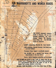 Ringwood and District Historical Society
Map, Partially Trimmed Copy of Ringwood Heights Estate, Ringwood, Vic. - circa 1923
Clipped copy of a subdivision advertisement on cardboard backing. Sales notations on numbered allotments in Andersons's Creek Road (later Warrandyte Road) and Wonga Road, Ringwood. Handwritten title reference - LP7305. Captions - This Estate commands extensive views of mountain, hill and dale including Dandenong and Great Dividing Ranges, Mt. Macedon, Keilor Plains, etc. The outlook cannot be surpassed. Climate invigorating, mountain air, good rainfall. Land undulating, splendid drainage; soil, sandy loam on gravel subsoil. Permanent water supply is practically assured. The district has a splendid train service, with electrification in the near future. Electric light & telephone connection can be arranged. Keep in mind this estate is only 1 mile 25 chains from the up-to-date town of Ringwood which has all the trading conveniences of a semi-suburban town and is the centre of one of the largest fruit growing districts in the state. Distance from Melbourne by first class motor road, 16 miles. -
 Merri-bek City Council
Photograph - Pigment inkjet print dry mounted to Dibond, Peta Clancy, here merri merri lies 8, 2024
... and connection to Land, specifically merri merri, which has been her home ...