Showing 466 items
matching conservation areas
-
 Kew Historical Society Inc
Photograph - Civic event in Stradbroke Park, 1976
Stradbroke Park. Extent: Kilby Road to Harp Road at Burke Road. Historical Documentation: 1851 - Portion 91 purchased by Edward Glynn; 1888 - The Harp of Erin Estate (which included Section 91) offered for sale; 1896 - The area now known as Stradbroke Park was bisected by a creek that flowed from the Yarra via Hay's Paddock (q.v.) and extended through to Burke Road; 1943 - W.D. Birrell, Town Clerk of Kew, proposed that the creek be filled and a reserve created; 1954 - Entire area designated as 'open space' and named 'Stradbroke Park'. The line of the creek that ran through the Park created a further reserve on the north side of High Street, now known as 'Harrison Reserve'. Existing Condition: The park is largely of mown grass that has mature trees set into it It is possible that a number of these are remnant of the original vegetation, while there are also a number of exotic trees introduced, particularly at the northern end of the park. The southern end is dominated by playing fields. (Source: Sanderson, P 1988. Kew Conservation Study)Colour photographic positive (with colour degradation) of sporting teams at a civic event in Stradbroke Park in Kew East in May 1976. The event was officiated by the Mayor of Kew, Cr Alan Hutchinson. Stradbroke Park is situated on the western boundary of Kew and bordered by Burke and Harp Roads.stradbroke park, cr alan hutchinson, team sports -- kew (vic.) -
 Kew Historical Society Inc
Photograph - Willsmere [Kew] Billabong, 1993
Willsmere Park is bounded by the the Yarra River, Green Acres Golf Club, Willow Grove and the Eastern Freeway. The land on which the park is now situated was bought by Thomas Wills at the Crown Land Sales of 1846 (Section 56). From the 1840s to the 1940s it was intensively farmed. The park is dominated by very large playing fields, while planting to the southern boundary was undertaken when the Eastern Freeway was built. It is only along the banks of the Yarra that there is any remnant native vegetation. Willsmere Park is of significance as an area of open land that remains from the flood plain that once dominated northern Kew. (Source: Kew Conservation Study, 1988)Original colour small format polaroid photograph of the 'Kew Billabong' in the Willsmere Park, taken on 16 September 1993."Willsmere Billabong 16.9.93"kew billabong, willsmere park, yarra river -- billabongs -
 Kew Historical Society Inc
Photograph - Yarra River in flood at the Willsmere Park, 1993
Willsmere Park is bounded by the the Yarra River, Green Acres Golf Club, Willow Grove and the Eastern Freeway. The land on which the park is now situated was bought by Thomas Wills at the Crown Land Sales of 1846 (Section 56). From the 1840s to the 1940s it was intensively farmed. The park is dominated by very large playing fields, while planting to the southern boundary was undertaken when the Eastern Freeway was built. It is only along the banks of the Yarra that there is any remnant native vegetation. Willsmere Park is of significance as an area of open land that remains from the flood plain that once dominated northern Kew. (Source: Kew Conservation Study, 1988)Original colour small format polaroid photograph of the Yarra River in flood at the Willsmere Park, taken on 16 September 1993."Yarra River at Willsmere Park Flooding 16.9.93"willsmere park, yarra river -- floods -- kew (vic.) -
 Kew Historical Society Inc
Photograph - Flooding in the Willsmere Park, 1993
Willsmere Park is bounded by the the Yarra River, Green Acres Golf Club, Willow Grove and the Eastern Freeway. The land on which the park is now situated was bought by Thomas Wills at the Crown Land Sales of 1846 (Section 56). From the 1840s to the 1940s it was intensively farmed. The park is dominated by very large playing fields, while planting to the southern boundary was undertaken when the Eastern Freeway was built. It is only along the banks of the Yarra that there is any remnant native vegetation. Willsmere Park is of significance as an area of open land that remains from the flood plain that once dominated northern Kew. (Source: Kew Conservation Study, 1988)Original colour small format polaroid photograph of flooding in the Willsmere Park, taken on 16 September 1993."Flooding of shared path from Willsmere Billabong 16.9.93"willsmere park, yarra river -- floods -- kew (vic.), kew billabong -
 Kew Historical Society Inc
Photograph - Flooding in the Willsmere Park, 1993
Willsmere Park is bounded by the the Yarra River, Green Acres Golf Club, Willow Grove and the Eastern Freeway. The land on which the park is now situated was bought by Thomas Wills at the Crown Land Sales of 1846 (Section 56). From the 1840s to the 1940s it was intensively farmed. The park is dominated by very large playing fields, while planting to the southern boundary was undertaken when the Eastern Freeway was built. It is only along the banks of the Yarra that there is any remnant native vegetation. Willsmere Park is of significance as an area of open land that remains from the flood plain that once dominated northern Kew. (Source: Kew Conservation Study, 1988)Original colour small format polaroid photograph of flooding in the Willsmere Park, taken on 16 September 1993."Flooding of Willsmere Park from Yarra 16.9.93"willsmere park, yarra river -- floods -- kew (vic.) -
 Kew Historical Society Inc
Photograph - Flooding of Willsmere Park from Yarra, 1993
Willsmere Park is bounded by the the Yarra River, Green Acres Golf Club, Willow Grove and the Eastern Freeway. The land on which the park is now situated was bought by Thomas Wills at the Crown Land Sales of 1846 (Section 56). From the 1840s to the 1940s it was intensively farmed. The park is dominated by very large playing fields, while planting to the southern boundary was undertaken when the Eastern Freeway was built. It is only along the banks of the Yarra that there is any remnant native vegetation. Willsmere Park is of significance as an area of open land that remains from the flood plain that once dominated northern Kew. (Source: Kew Conservation Study, 1988)Original colour small format polaroid photograph of flooding in Willsmere Park resulting from heavy rain on 15 September 1993."Flooding of Willsmere Park from Yarra 16.9.93"yarra river -- floods -- kew (vic.), willsmere park -
 Kew Historical Society Inc
Photograph - Willsmere [Kew] Billabong, 1993
Willsmere Park is bounded by the the Yarra River, Green Acres Golf Club, Willow Grove and the Eastern Freeway. The land on which the park is now situated was bought by Thomas Wills at the Crown Land Sales of 1846 (Section 56). From the 1840s to the 1940s it was intensively farmed. The park is dominated by very large playing fields, while planting to the southern boundary was undertaken when the Eastern Freeway was built. It is only along the banks of the Yarra that there is any remnant native vegetation. Willsmere Park is of significance as an area of open land that remains from the flood plain that once dominated northern Kew. (Source: Kew Conservation Study, 1988)Original colour small format polaroid photograph of Willsmere [Kew] Billabong on September 1993."Willsmere Billabong 16.9.93"yarra river -- floods -- kew (vic.), willsmere park -
 Kew Historical Society Inc
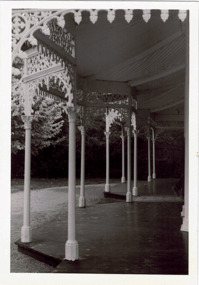
Photograph - Verandah of 'Wimba', 235 Cotham Road, John T Collins, 1979
Although probably built some time earlier, the first mention in the Rate Books of the property later known as 'Wimba Lodge' appears in the entry for 1870 when the property, owned by John Sharpe Denbigh, a civil servant, was given an N.A.V. of £72. Denbigh did however occupy a house in Cotham Road in 1863, and it is possible that was the same premises'. The house was occupied by Sharp until at least May 1876 when the 'family residence ... was auctioned' to Carlington George Edmund Marston, a chemist of Smith Street, Collingwood. At the time of the auction the house was described thus: The residence and grounds of the late J.S. Dendigh, situate in the most elevated part of Cotham Road Kew. The grounds comprise an area of 4a Or 29p or thereabouts, and have a frontage to Cotham-road of 4 chains. The house has two large rooms in front, with 6ft hall built of brick, bay and side windows (plate glass), four rooms of wood behind with slate roofs, bathroom and closets, detached kitchen and servant's room, large shed with washing boiler, pantry and cellar under, brick and cement tank, and the Yan Yean laid onto house and grounds, cowshed, pigstye, &c, the whole securely fenced. First class orchard and flower garden. The paddocks laid with English grasses and drained... .' (Sanderson P. Kew Conservation Study Vol 2)'Wimba' is a single storeyed rendered house. The front entrance is flanked by two polygonal bay windows, and a verandah with a concave corrugated iron roof returns around three facades, and accentuates the projections of the windows. The solid render parapet is very ornate and tall for the date of construction. It has panels of decoration along it and is surmounted by a number of render urns. (Sanderson P. Kew Conservation Study Vol 2)Reverse: "JOHN COLLINS / 11 Anderson Road / Hawthorn East, 3123 / Film 395 Exposure 15A / Kew / Wimba / Front verandah from east / 7-4-79wimba lodge, 235 cotham road -- kew (vic.), john s denbigh, carlington george edmund marston -
 Sunbury Family History and Heritage Society Inc.
Photograph, Gellibrand Hill
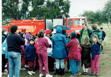
The students from Bulla Primary School were taken on an excursion to Gellibrand Hill, a native parkland near Bulla. They did tree-planting and were taken for a ride around the park in the conservation and environment truck. After the ride a park ranger spoke to the group about the park and its importance in the local area.The excursion was included as part of the students science and environmental studies.A non-digital photograph of a group of children gathered around a red truck controlled by the Conservation and Environment personnel while a man explains to the children the importance of the vehicle. They are in a semi-bushland area. gellibrand hill, tree planting, bulla primary school, school excursions -
 Williamstown Botanic Gardens- Hobsons Bay City Council
Oral History - Williamstown Botanic Gardens - Cyril Curtain, 24 July 2014
The interview is one of a series recorded in 2013-2014 to document memories and experiences of the Williamstown Botanic Gardens Cyril Curtain was born in Williamstown in 1928. He attended North Williamstown Primary School and Williamstown High School. Shortly after marrying he purchased a house on the Esplanade, where he still lives and in which this interview took place. Cyril’s work in conservation of the natural and built heritage is highly regarded. The recently developed Cyril Curtain Reserve in Williamstown is named in his honour. In this interview Cyril discusses the Gardens and the foreshore area including the beach and L A Parker Reserve A primary source of information on memories of the Gardens.CD and transcript of interview with Cyril Curtain and his memories of the Gardens and surrounding environs.fish pond, curator, cannons, williamstown botanic gardens, hobsons bay city council, aviary, pinetum, centennial reserve, midsummers night dream, cable tram car seats, infrared photography, , rotunda, gloucester reserve, 1934 storm, national trust, bateman house, clarke statue -
 Surrey Hills Historical Society Collection
Book, Medlow and the Bismark Estate by Prof. Miles Lewis, 1990
The Medlow Estate is a remarkable testimony to the unfulfilled expectations of the land boom of the 1880s to early 1890s. The areas of the former lot 14 or the lines of Varzin Avenue and Friedrichsruh Street where they pass through the present grounds will be conserved as may seem appropriate to exhibit the development of the garden in the Cairncross and Bull periods.The Medlow Estate is a remarkable testimony to the unfulfilled expectations of the land boom of the 1880s to early 1890s. The areas of the former lot 14 or the lines of Varzin Avenue and Friedrichsruh Street where they pass through the present grounds will be conserved as may seem appropriate to exhibit the development of the garden in the Cairncross and Bull periods.bismark estate, rosalie estate, conservation of natural resources, (mr) rex swanson, landform australia, cairncross family, medlow, varzin avenue, warrigal road, surrey hills, friedrichsruh street, (mr) (dr) r j bull, (miss) mary jane cairncross, g n taylor -
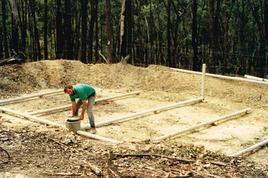 Round the Bend Conservation Co-operative
A member building a transpiration bed to recycle the household water. This is a way of concentrating absorption trenches in a confined area, managing waste water and containing the soil disturbance to the site
-
 National Wool Museum
Photograph - Portrait of Dr John Newman, Nicole Marie, 2021
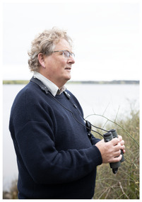
... and played a crucial role in protecting the area as a conservation... and played a crucial role in protecting the area as a conservation ...Thousands of volunteers work tirelessly to conserve and protect the environment of Geelong and the Bellarine. Their work often goes unnoticed. In 'The Work of Nature' the National Wool Museum and the Environment Department at the City of Greater Geelong worked with photographer Nicole Marie to showcase the significant contribution of environment volunteers in our region. Each of the eight people showcased in these portraits were nominated by their peers and members of the community for their significant contribution to conserving and protecting the environment. Dr John Newman - Geelong Field Naturalists Club Over almost twenty years John Newman has organised large groups of volunteers to conduct surveys across Geelong and the Bellarine for shorebirds and waterbirds. Understanding and collecting important environmental data helps in the effort to preserve important sites, much of this data is collected by volunteers. The information collected in Geelong and the Bellarine also forms part of national and international datasets that helps in understanding global patterns of migratory birds, such as sharp-tailed sandpiper, red-necked stint and the critically endangered curlew sandpiper. The data collected at the Moolap Saltworks (since 1981) and co-ordinated by John since 2003 highlighted the importance of this site for these three species and played a crucial role in protecting the area as a conservation site. Photo at Taits Point, Lake Connewarre Wildlife Reserve by Nicole Marie.Image showing an environmental portrait of a man holding binoculars with a water landscape in the background.environment, conservation, portraits, geelong, nature, exhibition, work of nature, geelong nature forum, volunteers, lake connewarre -
 National Wool Museum
Photograph - Portrait of Jarrah Wadsworth, Nicole Marie, 2021
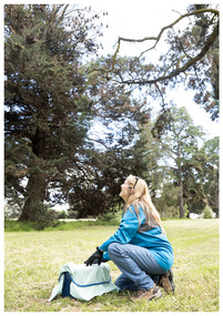
Thousands of volunteers work tirelessly to conserve and protect the environment of Geelong and the Bellarine. Their work often goes unnoticed. In 'The Work of Nature' the National Wool Museum and the Environment Department at the City of Greater Geelong worked with photographer Nicole Marie to showcase the significant contribution of environment volunteers in our region. Each of the eight people showcased in these portraits were nominated by their peers and members of the community for their significant contribution to conserving and protecting the environment. Jarrah Wadsworth - Friends of Bats and Bushcare Geelong Grey-headed flying foxes are listed as nationally threatened. They play a critical role in hardwood forest pollination and seed dispersal. They are often not well liked and can be seen as more of a nuisance than an asset to an area. Their numbers are rapidly declining. As the world warms and we experience more days of extreme heat they are increasingly threatened. Jarrah is a registered vet nurse and in her spare time heads up the Friends of Bats and Bushcare Geelong volunteer group. She is the coordinator of the FBBG and plays a key role in supporting the Geelong grey-headed flying fox population in Eastern Park and ensuring they survive extreme heat events. Photo at Eastern Park flying fox camp by Nicole Marie.Image showing an environmental portrait of a woman crouched on grass below trees where fruit bats are roosting.environment, conservation, portraits, geelong, nature, exhibition, work of nature, geelong nature forum, volunteers, eastern park -
 Canterbury History Group
Document - Mirabella, 62 Wattle Valley Road, Canterbury
, From the Camberwell Conservation Study - Significant Sites, on "Mirabella" 62 Wattle Valley Road Canterbury. Includes a list of comparative sites in the Camberwell area.canterbury, wattle valley road, mirabella, camberwell conservation study, williams> frank, zelman family -
 Falls Creek Historical Society
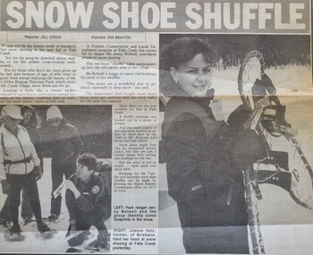
Article - Snow Shoe Shuffle, 30 July 1986
This article reports on the latest fad - snow shoe lessons, being conducted at Falls Creek by Ms Jenny Bolwell for the Forests, Conservation and Lands Department in 1986. The two hour "shuffle" took participants up into the sub-alpine area of the village. The snow shoe lessons had been held for the previous two seasons. Bookings were available each Tuesday and Saturday during the snow season.This article is significant because it documents the variety of activities available at Falls Creek during its development.A newspaper item about the new fad at Falls Creek - snow shoeing.snow shoes, falls creek activities -
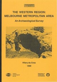 Bacchus Marsh & District Historical Society
Book, The Western Region: Melbourne Metropolitan Area: An Archaeological Survey
This study aimed to locate and document Aboriginal archaeological sites in the western region of Melbourne. This area was defined by the study as extending out from the western suburbs of Melbourne to the Brisbane Ranges and north beyond Bacchus Marsh. The specific aim of the study was to investigate the Aboriginal archaeology of the Western Plains area in the vicinity west of Melbourne. The Bacchus Marsh, Melton and Werribee shire boundaries of the time defined the areas of the study. The study contains extensive lists of the types of artifacts found the the locations where they were found.Soft cover foolscap size book. 96 pages with b & w illustrations, images and maps (some folded). Part of Occasional reports series (Victoria Archaeological Survey) ; No. 27. Published by Department of Conservation and Environment, Melbourne, 1990. Author, Hilary Du Cros. BMDHS Loc. AR/SU5This study aimed to locate and document Aboriginal archaeological sites in the western region of Melbourne. This area was defined by the study as extending out from the western suburbs of Melbourne to the Brisbane Ranges and north beyond Bacchus Marsh. The specific aim of the study was to investigate the Aboriginal archaeology of the Western Plains area in the vicinity west of Melbourne. The Bacchus Marsh, Melton and Werribee shire boundaries of the time defined the areas of the study. The study contains extensive lists of the types of artifacts found the the locations where they were found. aboriginal australians victoria western plains, aboriginal artifacts, archaelogical sites victoria western plains, aboriginal artifacts bacchus marsh region -
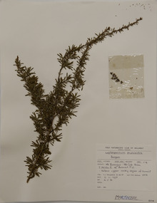
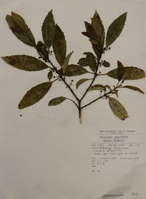
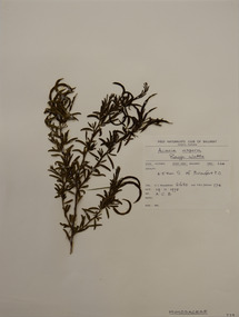
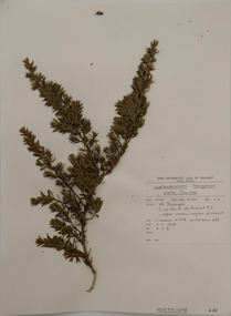 Federation University Herbarium
Plant specimen, Alexander Clifford Beauglehole, Leptospermum lanigerum (Aiton) Sm, 5/11/1978
Cliff Beauglehole was an orchardist at Portland, Victoria, who throughout hislife took an intense interest in the plants of Victoria. Over his lifetime he collected 90,000 plant specimens as part of a comprehensive study of Victoria's plants and wrote thirteen books under the heading The Distribution and Conservation of Vascular Plants in Victoria, each written to cover the 13 study areas of the Victorian and Conservation Council.A mounted botanical specimen.beauglehole herbarium, herbarium specimen, botany, herbarium, plant science, plant specimen, field naturalists' club ballarat, federation university herbarium, leptospermum lanigerum, woolly tea-tree, myrtaceae -
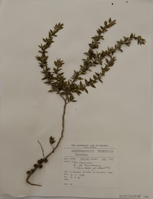
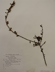
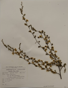 Federation University Herbarium
Plant specimen, Alexander Clifford Beauglehole, Leptospermum myrsinoides Schltdl, 1/11/1978
Cliff Beauglehole was an orchardist at Portland, Victoria, who throughout hislife took an intense interest in the plants of Victoria. Over his lifetime he collected 90,000 plant specimens as part of a comprehensive study of Victoria's plants and wrote thirteen books under the heading The Distribution and Conservation of Vascular Plants in Victoria, each written to cover the 13 study areas of the Victorian and Conservation Council.A mounted botanical specimen.beauglehole herbarium, herbarium specimen, botany, herbarium, plant science, plant specimen, field naturalists' club ballarat, federation university herbarium, leptospermum myrsinoides, heath tea-tree, myrtaceae -
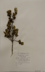 Federation University Herbarium
Plant specimen, Alexander Clifford Beauglehole, Leptospermum nitidum Hook.f
Cliff Beauglehole was an orchardist at Portland, Victoria, who throughout hislife took an intense interest in the plants of Victoria. Over his lifetime he collected 90,000 plant specimens as part of a comprehensive study of Victoria's plants and wrote thirteen books under the heading The Distribution and Conservation of Vascular Plants in Victoria, each written to cover the 13 study areas of the Victorian and Conservation Council.A mounted botanical specimen.beauglehole herbarium, herbarium specimen, botany, herbarium, plant science, plant specimen, field naturalists' club ballarat, federation university herbarium, leptospermum nitidum, shiny tea-tree, myrtaceae -
 Federation University Herbarium
Plant specimen, Alexander Clifford Beauglehole, Leptospermum phylicoides (A.Cunn. ex Schauer) Cheel, 6/11/1978
Cliff Beauglehole was an orchardist at Portland, Victoria, who throughout hislife took an intense interest in the plants of Victoria. Over his lifetime he collected 90,000 plant specimens as part of a comprehensive study of Victoria's plants and wrote thirteen books under the heading The Distribution and Conservation of Vascular Plants in Victoria, each written to cover the 13 study areas of the Victorian and Conservation Council.A mounted botanical specimen.beauglehole herbarium, herbarium specimen, botany, herbarium, plant science, plant specimen, field naturalists' club ballarat, federation university herbarium, leptospermum phylicoides, burgan, myrtaceae -
 Federation University Herbarium
Plant specimen, Alexander Clifford Beauglehole, Leptospermum scoparium J.R.Forst. & G.Forst, 2/11/1978
Cliff Beauglehole was an orchardist at Portland, Victoria, who throughout hislife took an intense interest in the plants of Victoria. Over his lifetime he collected 90,000 plant specimens as part of a comprehensive study of Victoria's plants and wrote thirteen books under the heading The Distribution and Conservation of Vascular Plants in Victoria, each written to cover the 13 study areas of the Victorian and Conservation Council.A mounted botanical specimen.beauglehole herbarium, herbarium specimen, botany, herbarium, plant science, plant specimen, field naturalists' club ballarat, federation university herbarium, leptospermum scoparium, manuka, myrtaceae -
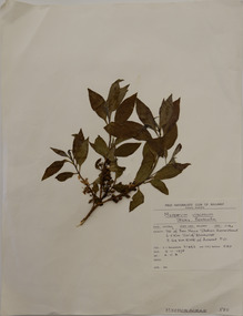 Federation University Herbarium
Plant specimen, Alexander Clifford Beauglehole, Myoporum viscosum R.Br, 9/11/1978
Cliff Beauglehole was an orchardist at Portland, Victoria, who throughout hislife took an intense interest in the plants of Victoria. Over his lifetime he collected 90,000 plant specimens as part of a comprehensive study of Victoria's plants and wrote thirteen books under the heading The Distribution and Conservation of Vascular Plants in Victoria, each written to cover the 13 study areas of the Victorian and Conservation Council.A mounted botanical specimen.beauglehole herbarium, herbarium specimen, botany, herbarium, plant science, plant specimen, field naturalists' club ballarat, federation university herbarium, myoporum viscosum, sticky boobialla, scrophulariaceae -
 Federation University Herbarium
Plant specimen, Alexander Clifford Beauglehole, Micromyrtus ciliata (Sm.) Druce, 3/11/1978
Cliff Beauglehole was an orchardist at Portland, Victoria, who throughout hislife took an intense interest in the plants of Victoria. Over his lifetime he collected 90,000 plant specimens as part of a comprehensive study of Victoria's plants and wrote thirteen books under the heading The Distribution and Conservation of Vascular Plants in Victoria, each written to cover the 13 study areas of the Victorian and Conservation Council.A mounted botanical specimen.beauglehole herbarium, herbarium specimen, botany, herbarium, plant science, plant specimen, field naturalists' club ballarat, federation university herbarium, micromyrtus ciliata, heath-myrtle, myrtaceae -
 Federation University Herbarium
Plant specimen, Alexander Clifford Beauglehole, Hedycarya angustifolia R.Cunn, 6/11/1978
Cliff Beauglehole was an orchardist at Portland, Victoria, who throughout hislife took an intense interest in the plants of Victoria. Over his lifetime he collected 90,000 plant specimens as part of a comprehensive study of Victoria's plants and wrote thirteen books under the heading The Distribution and Conservation of Vascular Plants in Victoria, each written to cover the 13 study areas of the Victorian and Conservation Council.A mounted botanical specimen.beauglehole herbarium, herbarium specimen, botany, herbarium, plant science, plant specimen, field naturalists' club ballarat, federation university herbarium, hedycarya angustifolia, djelwuck, austral mulberry, monimiaceae -
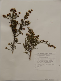
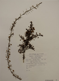
 Federation University Herbarium
Plant specimen, Alexander Clifford Beauglehole, Acacia acinacea Lindl, 25/10/1978
Cliff Beauglehole was an orchardist at Portland, Victoria, who throughout hislife took an intense interest in the plants of Victoria. Over his lifetime he collected 90,000 plant specimens as part of a comprehensive study of Victoria's plants and wrote thirteen books under the heading The Distribution and Conservation of Vascular Plants in Victoria, each written to cover the 13 study areas of the Victorian and Conservation Council.A mounted botanical specimen.beauglehole herbarium, herbarium specimen, botany, herbarium, plant science, plant specimen, field naturalists' club ballarat, federation university herbarium, acacia acinacea, fabaceae, gold-dust wattle -
 Federation University Herbarium
Plant specimen, Alexander Clifford Beauglehole, Acacia aculeatissima J.F.Macbr, 23/10/1978
Cliff Beauglehole was an orchardist at Portland, Victoria, who throughout hislife took an intense interest in the plants of Victoria. Over his lifetime he collected 90,000 plant specimens as part of a comprehensive study of Victoria's plants and wrote thirteen books under the heading The Distribution and Conservation of Vascular Plants in Victoria, each written to cover the 13 study areas of the Victorian and Conservation Council.A mounted botanical specimen.beauglehole herbarium, herbarium specimen, botany, herbarium, plant science, plant specimen, field naturalists' club ballarat, federation university herbarium, acacia aculeatissima, thin-leaf wattle, fabaceae -
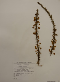 Federation University Herbarium
Plant specimen, Alexander Clifford Beauglehole, Acacia paradoxa DC, 23/10/1978
Cliff Beauglehole was an orchardist at Portland, Victoria, who throughout hislife took an intense interest in the plants of Victoria. Over his lifetime he collected 90,000 plant specimens as part of a comprehensive study of Victoria's plants and wrote thirteen books under the heading The Distribution and Conservation of Vascular Plants in Victoria, each written to cover the 13 study areas of the Victorian and Conservation Council.A mounted botanical specimen.beauglehole herbarium, herbarium specimen, botany, herbarium, plant science, plant specimen, field naturalists' club ballarat, federation university herbarium, acacia paradoxa, prickly wattle, fabaceae -
 Federation University Herbarium
Plant specimen, Alexander Clifford Beauglehole, Acacia aspera Lindl, 19/11/1978
Cliff Beauglehole was an orchardist at Portland, Victoria, who throughout hislife took an intense interest in the plants of Victoria. Over his lifetime he collected 90,000 plant specimens as part of a comprehensive study of Victoria's plants and wrote thirteen books under the heading The Distribution and Conservation of Vascular Plants in Victoria, each written to cover the 13 study areas of the Victorian and Conservation Council.A mounted botanical specimen.beauglehole herbarium, herbarium specimen, botany, herbarium, plant science, plant specimen, field naturalists' club ballarat, federation university herbarium, acacia aspera, rough wattle, fabaceae