Showing 300 items
matching frontages
-
 The Beechworth Burke Museum
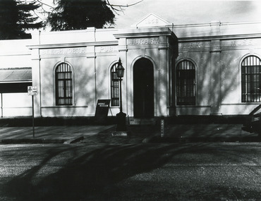
Photograph, c1970
Historical photograph taken of the frontage of the Burke Museum in Beechworth. As Australia’s oldest regional museum, the building used for the Burke Museum was originally built as the Beechworth Athenaeum, and was later dedicated as a museum in memorial to the explorer Robert O’Hara Burke, who died on the Burke and Wills expeditions in 1861. The Burke and Wills exhibitions were a significant colonial event that was memorialised in paintings, buildings, monuments, and statues. The photograph has historical significance, connecting with various themes such as exploring, establishing pathways, and significant colonial events or persons. The photograph depicts the frontage of the Burke Museum, which was dedicated as a memorial to the explorer Robert O’Hara Burke, who died on the Burke and Wills expeditions in 1861. Robert O’Hara Burke was a significant person who was connected to both Beechworth and to an important colonial event, the Burke and Wills expeditions. Born in Ireland, Burke migrated to Australia in 1853 and nearly a year later, was appointed to senior inspector at Beechworth. Described as quick-tempered yet generous, Burke later joined an expedition to explore the interior of the Victorian colony, which was later termed the Burke and Wills expeditions. While the expeditions generated a significant amount of interest, the objectives of the Burke and Wills expeditions were hazy, as was its planned route, leading to disaster on the trip as group infighting, poor provisions, and a lack of clear instructions ultimately resulted in Burke’s death. Regardless, the Burke and Wills expeditions promoted discovery and endures today in popular memory.Black and white rectangular photograph printed on paper.Obverse: 1856/ BEECHWORTH/ PUBLIC/ LIBRARY/ BURKE/ MUSEUM/ BURK MUSEUM/ (parking signs illegible) Reverse: BMM 84-2-1/ A02989 1997 2696/ BMM 84-2-3burke museum, beechworth, beechworth athenaeum, athenaeum, memorial, robert o'hara burke, robert burke, burke and wills exhibitions -
 Warrnambool and District Historical Society Inc.
Sale Poster, Mercer Print, "Arran" 1967, 1967
This Auction notice is for the sale of an Ellerslie property called "Arran" , owned by Mr Philip M. Ormsby. The date of the auction is Thursday 16th February 1967. Vendors solicitors are Archer Naughtin and Forrest of Mortlake and the sale agents are Dennys, Lascelles Limited. Portions of "Arran" had been in the family since 1865. The property has 3/4 mile frontage to the Hopkins river.This sale notice is of general interest as a well established property in a good farming region. Long sheet with sale details of the property Arran The majority of the text is black with some highlighted in red.There is a map of the property on the reverse.warrnambool, arran, ellerslie -
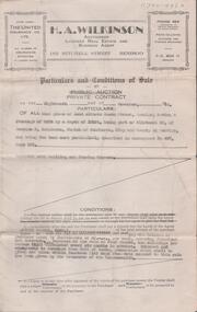
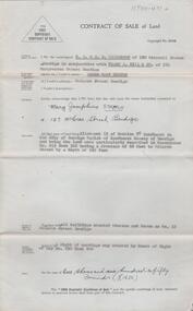
 Bendigo Historical Society Inc.
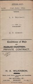
Document - H.A. & S.R. WILKINSON COLLECTION: CONTRACT OF SALE
Conditions of sale by private contract dated 21st July, 1933 between L.G. Thirlwell (seller) and M.B. Simmons (buyer) for land having a frontage of about 109 feet to Hargreaves Street, Bendigo by a depth of 166 feet being the land described in residence area certificate no. 33019 in the books of the Mining Registrar at Bendigo, together with 6-roomed weatherboard dwelling and all sundry. Price 235 pounds.organization, business, h.a. & s.r wilkinson real estate -
 Bendigo Historical Society Inc.
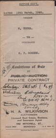
Document - H.A. & S.R. WILKINSON COLLECTION: CONDITION OF SALE
Conditions of sale by private contract issued by H.A. Wilkinson and dated 15th March, 1949 between W. Young (seller) and C.P. Rogers (buyer) for land situate in Brown Street Eaglehawk having a frontage of 129 links to Brown Street , by a depth of 192 links and being described in right of occupy residence area No. 5412, together with 5-roomed weatherboard dwelling and all sundry. Price 480 pounds.organization, business, h.a. & s.r wilkinson real estate -
 Charlton Golden Grains Museum Inc
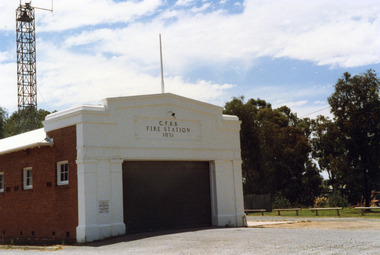
Photograph, Charlton Shire, Charlton Fire Station c. 1987, c.1987
The Charlton Fire Station was built in 1931.Colour photograph of the Charlton Fire Station. A single storey red brick building with a white frontage. A large entrance and three high high windows down the side. There is a plaque on the LH side of the main entrance that can't be clearly read.. The signage above the main entrance reads C.F.B.B. FIRE STATION 1931 There is a light above this sign. The fire tower is at the rear of the building. There is a low railing fence on the right side.charlton fire station, charlton fire brigade, public services -
 Bendigo Historical Society Inc.
Document - BEEBE, BAPTIST CHURCH DRAWING
Parchment paper architect drawing by William Beebe. Printed heading, 'Proposed Sunday School, Baptist Church', dated 21/9/ 05. Scale 8 feet to Inch. Eight rooms surrounding 30 feet x 50 feet main hall lighted by clearstory. Handwritten cost estimated if weatherboard £850, brick £1040, fencing not included. Land & house 72-foot frontage. Unknown donorbendigo, churches, baptist, beebe -
Phillip Island and District Historical Society Inc.
Photograph, circa 1900
Section of home frontage, single storey brick building. Elaborately decorated verandah roofing with lace wrought iron. Corrugated section painted in grey and white stripes. Mosaic style flooring of verandah in front of and to sides of lace curtained windows. Four figures of family, mother seated, son standing with hands on back of chair. Two daughters one standing and one kneeling in front.Partial exterior of family on verandah of home.local history, photography, photographs, slides, film, houses, black & white photograph, miss elms san remo -
![Newspaper clipping [copy], Greensborough farm 8500 [pounds], 23/12/1947](/media/collectors/4f729f5697f83e03086015b8/items/5d1d78dc21ea6a1138d1fd4a/item-media/5d1dcff421ea6b11381717d8/item-fit-380x285.jpg) Greensborough Historical Society
Greensborough Historical SocietyNewspaper clipping [copy], Greensborough farm 8500 [pounds], 23/12/1947
Corrabert Park was owned by Francis Flintoff, sold c. 1924 to Mr. E. Fullwood, who sold the property in December 1947 to Mr. W. M. Bamford for 8500 pounds. The land had frontage to the Plenty River and water from the MMBW aqueduct which passed through the property. There was a residence and two small rented cottages on the property. The area is currently known as Apollo Parkways.Copy of news clipping.Corrabert Park sold - newspapers.comcorrabert park, apollo parkways -
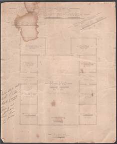
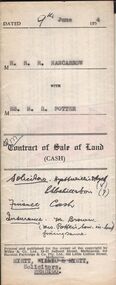 Bendigo Historical Society Inc.
Document - H.A. & S.R. WILKINSON COLLECTION: CONDITION OF SALE
Contract of sale of land (cash) dated 9th June, 1954 between Mr. R.R. Nancarrow (seller) and Mrs M.R. Potter (buyer) for land above 50 feet below the surface and all that piece of land being part of allotment section K Parish of Sandhurst, City and County of Bendigo described in the plan at the end hereof and thereon coloured red with a frontage to Atkins Street, Bendigo. Price 1,700 pounds.organization, business, h.a. & s.r wilkinson real estate -
Bendigo Historical Society Inc.
Document - The Royal Princess Theatre Story, 2001
The Royal Princess Theatre was opened on 31st August 1874. The cost of the building was £12,000 with a capacity of 2,000 people. The building was designed by William Charles Vahland. The site was at the corner of View Street and McKenzie Street, with the frontage facing View Street. The auditorium was on three levels and seated 650 in the pit (rear stalls), 200 in the stalls, 250 in the dress circle and 850 in the gallery. A further 50 were seated in the six stage boxes. The frontage of the theatre was 80ft wide x 60ft, which inside the auditorium the proscenium was 30ft wide by 18ft high. The stage was 56ft deep. Stage lighting at the time was by gas until the Electric Supply Co, of Victoria Ltd. had DC power available in 1898. The theatre was described as comparable to anything Drury Lane in London had to offer. The original proprietor’s of the theatre John Croley died on 26th March 1899 aged 72 years, while William Billy Heffernan died 23rd March 1891 aged 81 years.The Royal Princess Theatre Bendigo History Notes, provided by Fred Page for the Bendigo Historical Society. Three pages of notes and photographs photocopied from an unknown book pp 24 - 26.history, bendigo, royal princess theatre -
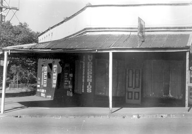 Surrey Hills Historical Society Collection
Photograph, 109 Union Road, Surrey Hills after fire damage
This building was damaged by fire and was subsequently demolished before June 1983. From 1901-1917 it was the site of the Surrey Hills Post Office. In later years the part of the building with frontage to Windsor Crescent was used as the dental surgery of Dr David Ellis; the Union Road part of the building was occupied by a barber and tobacconist for many years. At the time of the fire the building was used by a business supplying hydroponics requirements. This moved to (?) 119 Highbury Road, Burwood.The image is significant because it documents a building which was an important community facility which no longer exists.Black and white photo of a single-storey corner building with a corrugated iron roofed veranda and a single, 4-panel timber door. There is a sign with '109' mounted on the veranda of the building. There are multiple advertising signs on the walls of the building. Two of the windows are boarded up with corrugated iron sheets.shops, barber shops, tobacconists, surrey hills post office, dentists, union road, windsor crescent, hydroponics supplies, businesses, union road shops, dr david ellis -
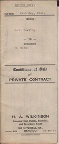 Bendigo Historical Society Inc.
Document - H.A. & S.R. WILKINSON COLLECTION: CONDITION OF SALE
Conditions of sale by private contract dated 20th May, 1943 between A.E. Cowling (seller) and H. Rice (buyer) for land situate Wood Street, Long Gully having a frontage of 150 links to Wood Street by a depth of 200 links and being the land described in right to occupy residence area title No. 4719 due 23/08/1943, together with 5-roomed weatherboard dwelling and all sundry. Price 225 pounds.organization, business, h.a. & s.r wilkinson real estate -
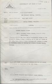
 Bendigo Historical Society Inc.
Document - H. A. & S. R. WILKINSON COLLECTION: CONTRACT OF SALE
Conditions of sale by private contract dated 18th November, 1947 between Mrs. A. A. Goodisson (vendor) and Mr. A. E. Stirton (purchaser). Property: land situate Lucan Street, Bendigo having a frontage of 33 feet by a depth of 165 feet, being part of allotment 35 section E, Parish of Sandhurst City of Bendigo, land described in conveyance No. 487 book 561, together with building and fence thereon. Price: 155 pounds.organization, business, h.a. & s.r wilkinson real estate -
 Bendigo Historical Society Inc.
Slide - DIGGERS & MINING. GETTING THE GOLD, c1855
Diggers & Mining. Getting the Gold. Slide: The evils of shepherding soon became obvious; shepherds often prospered by the ruin of parties who really worked their claims. The Ballarat diggers, through their local Court, abolished shepherding in 1855, and instituted a complicated 'frontage' system which, in effect, guaranteed the diggers who went to the expense and hardship of sinking a shaft the right to work a section of the lead. Markings: 58 994.LIF:4. Used as a teaching aid.hanimounteducation, tertiary, goldfields -
 Kew Historical Society Inc
Plan - Subdivision Plan, Palmyra Estate, 1918
Pru Sanderson, in her groundbreaking ‘City of Kew Urban Conservation Study : Volume 2 - Development History’ (1988), summarised the periods of urban development and subdivisions of land in Kew. The periods that she identified included 1845-1880, 1880-1893, 1893-1921, 1921-1933, 1933-1943, and Post-War Development. These periods were selected as they represented periods of rapid growth or decline in urban development. An obvious starting point for Sanderson’s groupings involved population growth and the associated economic cycles. These cycles also highlighted urban expansion onto land that was predominantly rural, although in other cases it represented the decline and breakup of large estates. A number of the plans in the Kew Historical Society’s collection can also be found in other collections, such as those of the State Library of Victoria and the Boroondara Library Service. A number are however unique to the collection.The Kew Historical Society collection includes almost 100 subdivision plans pertaining to suburbs of the City of Melbourne. Most of these are of Kew, Kew East or Studley Park, although a smaller number are plans of Camberwell, Deepdene, Balwyn and Hawthorn. It is believed that the majority of the plans were gifted to the Society by persons connected with the real estate firm - J. R. Mathers & McMillan, 136 Cotham Road, Kew. The Plans in the collection are rarely in pristine form, being working plans on which the agent would write notes and record lots sold and the prices of these. The subdivision plans are historically significant examples of the growth of urban Melbourne from the beginning of the 20th Century up until the 1980s. A number of the plans are double-sided and often include a photograph on the reverse. In 1918, Punch reported the sale of the Palmyra Estate. ‘Adjoining the Findon Estate at Kew is Palmyra, one of the most charming localities in this most desirable of all suburbs. Palmyra has frontages to Findon, Bakewell, Carson and Stevenson streets. Facing Carson street are eight blocks of 60 by 140; on Stevenson-street four of 60 by 232; and there are four of 60 by 233 on Bakewell-street.’ [Bakewell Street and Findon Street were later to be amalgamated into Findon Crescent.]subdivision plans - kew, studley park, palymyra estate, stevenson street -- kew (vic.), carson street -- kew (vic.), bakewell street (findon crescent) -- kew (vic.) -
 Glen Eira Historical Society
Letter - Eastleigh Community Church, East Boundary Road, 216
Two items about this Church: 1/ Printed Email from Brian Walsh, giving brief details of his time at Eastleigh Community Church and McKinnon Gospel Hall dated 21/04/2010 and Reply dated 03/06/2012. 2/ 3 digital photos taken on 20/02/2010 by Claire Barton for GEHS project: 2 different views of the street frontage for the Church and 1 view of the sign on the front wall.pearson bob, deakin street, mckinnon, eastleigh community church, bentleigh east, eastleigh gospel chapel, walsh brian, coates lindsay, mckinnon gospel hall, east boundary road, bent street -
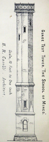 Federation University Historical Collection
Architectural Plan, Ballarat School of Mines Gauge Tower Architectural Plan, c1883
The Ballarat School of Mines was the first of its type in Australia. The Albert Street frontage was the 'working end' of the campus with the mining laboratory, gauge tower and caretakers cottage. All the structures in the foreground have been demolished to make way for the Flecknoe Building and the M.B. John Building. Harry Brew, the well known Ballarat School of Mines caretaker, lived in the small weatherboard building to the right of the photograph. He was appointed to the staff at the Ballarat School of Mines in 1936.Printed copy of an architectural plan for the Ballarat School of Mines Gauge Tower as printed in the 1879 Ballarat School of Mines Annual Report.henry caselli, henry richards caselli, architectural plan, ballarat school of mines, gauge tower -
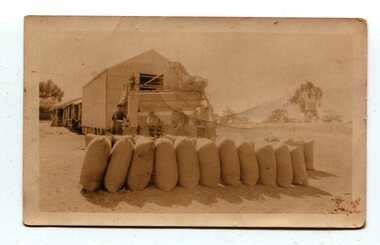 Orbost & District Historical Society
Photograph, 1930s
Maize has been grown on the Orbost flats for at least 70 years. When early settlers began to arrive on the Snowy River somewhere in the 1880s, the land was mostly swamps and heavily timbered jungle on the river frontages. The swamps were drained, bit by bit, with short handled shovels working in mud and water. The frontages were cleared by axe and shovel and fire. Several kinds of crops were experimented with such as hops, hemp and maize which grew particularly well and became the main crop of district. The problem then was to thresh and deliver the product to the market. A small single cob machine was brought here and one man turned the handle, while the boy or Mum fed the cobs singly into the machine. A good day’s work would thresh about 50 bushels or about 12 bags (4 bushels). The task then was to cart the maize to market. For a few years this was done by horses and dray carrying about 60 bushels to Mossiface, where it was loaded onto river boats to Lakes Entrance, and then by ocean boats to Melbourne. (information from NEWSLETTER OCTOBER, 2006)The growing of maize in the Orbost district contributed significantly to the economy of the township for many years, The many maize cribs once seen on the surrounding farms have now disappeared and this photograph is a pictorial record of that significance.A small sepia photograph with six men in front of a wooden barn. They are bagging maize. In the foreground are two rows of filled bags. On the right is a lifting machine to take the bags to the top storey. On the far right is a water tank on a stand"on back - "Thrashing Maize"maize-orbost agriculture-maize industry -
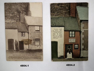 Bendigo Military Museum
Postcard - POSTCARDS - Scenic postcards from Wales, J.Jones et al
WW!, Tourist cards sent home by Joe Stuart.1. Sepia coloured photo of small house in Great Britain, located at Conway Quay, North Wales. The house is 6 feet wide. 2. Colourised picture of smallest house in Great Britain, Conway Quay. There is Lady in National dress, seated at the door doing knitting. 3. Colourised photo of kitchen of above. 4. Colourised photo of bedroom of above. The house size frontage 72 inches. Back to front 100 inches, Height 122 inches.1. On the rear Is addressed to "Dear Susie - Best love Joe". 2. 3. & 4. Nil on rear.wales, small housing -
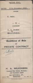 Bendigo Historical Society Inc.
Document - H.A. & S.R. WILKINSON COLLECTION: CONTRACT OF SALE
Conditions of sale by private contract dated 11th November, 1941 between H. Muir (seller) and C.E. Stokes & Mrs. J. Stokes (buyers) for land situate No. 718 High Street, Golden Square, together with 4-roomed weatherboard and rough cast dwelling and all sundry. Also all vendor's right title and interest in and to the adjoining land with a frontage to High street, and as fenced across the rear of the residence area land. Price 400 pounds.organization, business, h.a. & s.r wilkinson real estate -
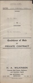 Bendigo Historical Society Inc.
Document - H.A. & S.R. WILKINSON COLLECTION: CONTRACT OF SALE
Conditions of sale by private contract dated 19th October, 1942 between D.R. Hay (seller) and H.A. Stirton (buyer) for land situate corner Creek and Hamann Streets, Bendigo, having a frontage of 85 links to Hamann Street by a depth of 134 links to Creek Street and adjoining allotments 6 and 4, and described in right to occupy residence area title No. 5429, together with 4-roomed weatherboard dwelling and all sundry. Price 270 pounds.organization, business, h.a. & s.r wilkinson real estate -
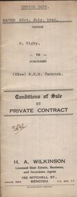 Bendigo Historical Society Inc.
Document - H.A. & S.R. WILKINSON COLLECTION: CONDITION OF SALE
Conditions of sale by private contract dated 23rd July, 1940 between R. Rigby (seller) and Miss B.E.M. Tancock (buyer) for land situate corner Violet and Queen Streets, Bendigo, having a frontage to Queen Street of approx. 71 links by a depth of approx. 137 links to Violet Street, being land described in right to occupy residence area no. 4868, together with 5-roomed weatherboard dwelling and all sundry. Price 155 pounds.organization, business, h.a. & s.r wilkinson real estate -
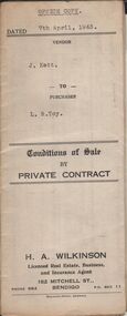 Bendigo Historical Society Inc.
Document - H.A. & S.R. WILKINSON COLLECTION: CONDITION OF SALE
Conditions of sale by private contract dated 7th April, 1943 between J. Kett (seller) and L. R. Toy (buyer) for all those pieces of land situate Panto Street Eaglehawk, being allotments 3,5 and 6 section 13A at Eaglehawk, having a frontage of 100 links to Panton Street and described in certificate of title volume 5159 folio 1031735, together with 7-roomed brick and weatherboard dwelling and all sundry. Price 400 pounds.organization, business, h.a. & s.r wilkinson real estate -
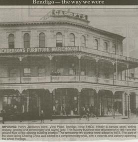 Bendigo Historical Society Inc.
Newspaper - JENNY FOLEY COLLECTION: IMPOSING
Bendigo Advertiser ''The way we were'' from 2000. Imposing: Henry Jackson's store, View Point, Bendigo, circa 1860s. Initially a canvas store, selling drapery, grocery and ironmongery and buying gold. The drapery business was disposed of in 1861 and the ground floor of the existing building erected. The remaining two storeys were added in 1872. The part of the store facing Charing Cross was added in a complementary style, with a veranda and balcony spanning the whole frontage. The clip is in a folder.newspaper, bendigo advertiser, the way we were -
 Bendigo Historical Society Inc.
Document - H. A. & S. R. WILKINSON COLLECTION: CONTRACT OF SALE
Contract of sale of land dated 30th July, 1954 between Miss A. M. Gibson (vendor) and Miss M. J. Stritch (purchaser). Property: Allotment 13 section 7C Parish of Sandhurst, City of Bendigo, land described in conveyance no. 253 book 326 having a frontage of 66 feet to McLaren Street by a depth of 165 feet, together with all buildings erected thereon and known as No. 12 McLaren street, Bendigo. Price: 1,650 pounds.organization, business, h.a. & s.r wilkinson real estate -
 Bendigo Historical Society Inc.
Document - H. A. & S. R. WILKINSON COLLECTION: CONTRACT OF SALE
Contract of sale of land dated 17th August, 1955 between Mr. H. B. Morgan (vendor) and Mr. L. H. Parsons (purchaser). Property: land being lot 3 on plan of subdivision lodged in the office of titles, having a frontage of 50 feet by a depth of 150 feet, being part of Crown allotment 547section H and situate in Osborne Street, Bendigo, together with 5 roomed weatherboard dwelling and all sundry. Price: 3,300 pounds.organization, business, h.a. & s.r wilkinson real estate -
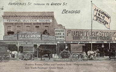 Bendigo Historical Society Inc.
Photograph - HARGREAVES AND QUEEN STREETS, 2nd June 1908
Hand-coloured postcard, Hargreaves through to Queen Streets, Bendigo. Three covered horse-drawn wagons with drivers, in front of Federal Auction rooms, Furniture Store. Large flag on pole - 'J.H. Curnow the Big Furniture Store', 'Office, House Land and Estate Agency', 'Farms, houses, building allotments, linoleums, carpets'. Inscriptions/markings: printed on card - 'Auction Rooms, Office and Furniture Store - Hargreaves Street, Sale Yards Frontage Queen Street.place, streetscape, hargreaves street -
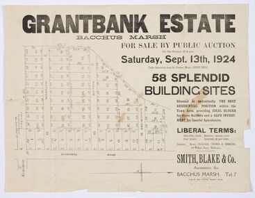 Bacchus Marsh & District Historical Society
Map - Land Sales Plan, Grantbank Estate Bacchus Marsh, 1924
The Grantbank Estate was a parcel of land close to the centre of the shopping area of Bacchus Marsh which was sub-divided and offered for sale in 58 lots on the 13th September, 1924. It comprised an area of 15 acres, being a portion of the Millbank Estate which had been in the hands of the Grant family for 75 years. The lots had frontages to Gisborne Road, Patterson, William and Sutherland Streets. This was a significant sub-division of land and represented a major expansion of residential housing in Bacchus Marsh in the early 20th century.This land sale map is a typical example of housing estate land sales advertising maps produced by real estate agents in this era. The map is significant for the detailed information it provides about when and where land was sold for new housing estates in Bacchus Marsh in the early twentieth century.Printed paper mapland sales bacchus marsh, land subdivsion bacchus marsh, housing estates land sales bacchus marsh, grant family bacchus marsh -
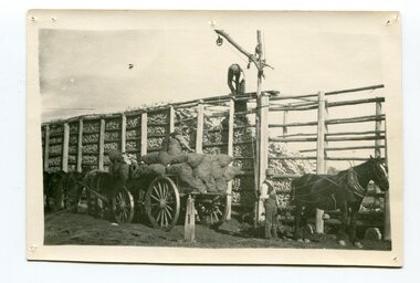 Orbost & District Historical Society
black and white photograph
Maize,has been grown on the Orbost flats for at least 70 years. When early settlers began to arrive on the Snowy River somewhere in the 1880s, the land was mostly swamps and heavily timbered jungle on the river frontages. The swamps were drained, bit by bit, by men with short handled shovels and working in mud and water. The frontages were cleared by axe and shovel and fire. Several kinds of crops were experimented with such as hops, hemp and maize, the latter grew particularly well and became the main crop of district. The problem then was to thresh and deliver the product to the market. A small single cob machine was brought here and one man turned the handle, while the boy or Mum fed the cobs singly into the machine. A good day’s work would thresh about 50 bushels or about 12 bags (4 bushels). The task then was to cart the maize to market. For a few years this was done by horses and dray carrying about 60 bushels to Mossiface, where it was loaded onto river boats to Lakes Entrance, and then by ocean boats to Melbourne. Later it was taken to Bairnsdale by foot and loaded onto the trains to Melbourne. (more information in Newsletter October 2006)The growing of maize in the Orbost district contributed significantly to the economy of the township for many years, The many maize cribs once seen on the surrounding farms have now disappeared and this photograph is a pictorial record of that significance.A black / white photograph of a man unloading maize from a horse-drawn wagon into a maize crib. Another man is standing by the horse.maize-crib-orbost agriculture maize-corn-orbost -
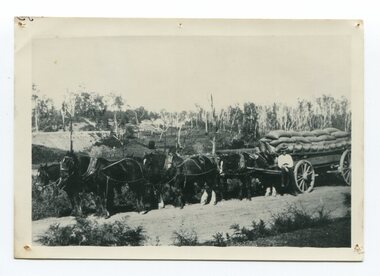 Orbost & District Historical Society
black and white photograph, late 19th century - early 20th century
Maize, or corn as it is called in America and New South Wales, has been grown on the Orbost flats for at least 70 years. When early settlers began to arrive on the Snowy River somewhere in the 1880s, the land was mostly swamps and heavily timbered jungle on the river frontages. The swamps were drained, bit by bit, by stout hearted men with short handled shovels and working in mud and water. The frontages were cleared by axe and shovel and fire. Several kinds of crops were experimented with such as hops, hemp and maize, the latter grew particularly well and became the main crop of district. The problem then was to thresh and deliver the product to the market. A small single cob machine was brought here and one man turned the handle, while the boy or Mum fed the cobs singly into the machine. A good day’s work would thresh about 50 bushels or about 12 bags (4 bushels). The task then was to cart the maize to market. For a few years this was done by horses and dray carrying about 60 bushels to Mossiface, where it was loaded onto river boats to Lakes Entrance, and then by ocean boats to Melbourne. ( from NEWSLETTER OCTOBER, 2006) This is a pictorial record of farming practices in Orbost in the early 20th century.A black / white photograph of a horse team hauling a wagon loaded with bags of maize.A man is sitting on the edge of the wagon.farming-orbost agriculture maize corn transport