Showing 1045 items matching "general view"
-
 Glenelg Shire Council Cultural Collection
Photograph - Photograph - View of Harbour from Victoria Parade, 1953
... Front: HARBOR FROM VICTORIA PARADE. 30.3.53./ General View... VICTORIA PARADE. 30.3.53./ General View. (lower centre) Back: P.H.T ...Port of Portland Authority archivesFront: HARBOR FROM VICTORIA PARADE. 30.3.53./ General View. (lower centre) Back: P.H.T./ Print No. 8/8 Neg. No P51/ Date taken 30.4.53./ SUBJECT./ % (Ink stamp with blue pen and pencil additions, centre) Partial fingerprint in purple ink, lower centre.port of portland archives -
 Ballarat Tramway Museum
Photograph - digital Images, Warren Doubleday
... tram terminus. Taken 12/11/2020 .1 - general view .2.../11/2020 .1 - general view .2 - view of the main panel ...Set of 6 digital images featured on the building on the south west corner of Barkly and Cobden Sts, the Mount Pleasant tram terminus. Taken 12/11/2020 .1 - general view .2 - view of the main panel with interpretative panels. .3 and .4 - view of the interpretative panels with credits - includes photo turned into a mural by Bob Wilson. .5 - map panel .6 - pamphlet box.trams, tramways, mount pleasant terminus, barkly st, history, heritage, interpretation -
 Melbourne Tram Museum
Photograph - Set of 7 postcard size photographs - Wattle Park MMTB, Melbourne & Metropolitan Tramways Board (MMTB), 1960s
... - Children's playground area 4 - General view of the footpaths and park... playground area 4 - General view of the footpaths and park 5 - one ...Set of 7 photographs, probably by the MMTB of Wattle Park. 1 - Wattle Park Chalet building 2 - ditto - side view 3 - Children's playground area 4 - General view of the footpaths and park 5 - one of the water features 6 - View of some of the buildings. 7 - part of the golf course.Yields information about Wattle Park during the 1960s, which was owned and maintained by the MMTB.Set of 7 black and white photographs.tramways, mmtb, wattle park, golf -
 Kiewa Valley Historical Society
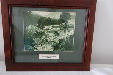
Set of 6 framed photographs - Kiewa Hydro Electric Scheme
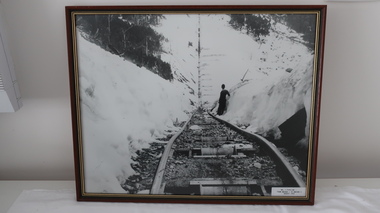
... September 1940 5. Junction Dam - General View from Downstream - 15th... Bridge - 9th September 1940 5. Junction Dam - General View from ...Official photos - Kiewa Hydro Electric Scheme constructed by State Electricity Commission of VictoriaOfficial photos of KHES in the Kiewa Valley1. Junction Dam Excavation - 5th April 1941 2. Bogong Residential Area Development - 24th April 1940 3. Beginning of Mt Beauty Township - 20th February 1947 4.Pretty Valley Bridge - 9th September 1940 5. Junction Dam - General View from Downstream - 15th September 1943 6. Construction of Dam Wall for Rocky Valley Dam - 1958khes, secv -
 Ballarat Tramway Museum
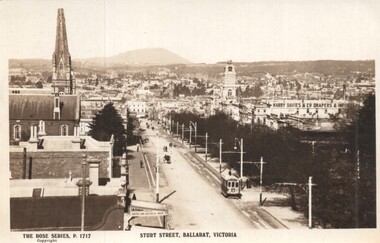
Postcard - Sturt Street Ballarat, Victoria, Rose Stereograph Co, 1920s?
... and the general view of the city. On the rear is a large Rose symbol... Importers, Ballarat Town Hall and the general view of the city ...Photo taken from the City Fire Brigade station at the corner of Sturt and Raglan Streets, looking east towards Mount Warrenheip. Has an eastbound ESCo tram. Photo shows the overhead structures, Harry Davies & Co. Drapers Importers, Ballarat Town Hall and the general view of the city. On the rear is a large Rose symbol and publisher details.Yields information about Sturt St during 1920sPostcard - Rose Series P 1717, Sturt Street looking east. Second copy - cigarette card size - 63mm x 87mmHas an address in Macarthur St, Ballarat on rear. Second copy has in ink "To Ken from Paul Kiwi4755"ballarat, sturt st, fire watch tower, harry davies -
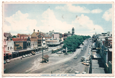 Ballarat Tramway Museum
Postcard - "Looking west up Sturt Street", Nu-color-vue or Nucolorvue Productions, 1960s
... in the parking loop, the small shelter and a general view looking west... in the parking loop, the small shelter and a general view looking west ...Postcard showing Sturt St from the building on the north east corner of Sturt and Grenville Sts. Shows three trams in the parking loop, the small shelter and a general view looking west along Sturt St. - 1960s. See also item 8703 for a mounted copy. The second copy in the stamp area has the postage rates for airmail.Yields information about Sturt St looking west from Grenville St.Postcard - colour with serated edges by Nu-color-vue - No. BT 52 - two copies held.trams, tramways, grenville st, sturt st, shelters, postcard -
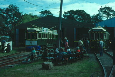 Ballarat Tramway Museum
Photograph - Digital image Set of 3, Warren Doubleday, 19/09/1981 12:00:00 AM
... of the depot extensions on 19/9/1981. .1 - general view with 40... - general view with 40 and 38 on the depot fan and that rock. Has ...Set of 3 Digital Images of the testing of the opening of the depot extensions on 19/9/1981. .1 - general view with 40 and 38 on the depot fan and that rock. Has the banner in position. .2 - ditto .3 - with Richard Gilbert speaking on the trolley. See Reg Item 2801 for the banner and the 1981- 1982 BTPS Annual Report for further details. From digital images from Warren Doubleday, pending transfer of the originals.trams, tramways, opening, depot extensions, btps, launch, banner, tram 38, tram 40 -
 Glen Eira Historical Society
Plan - LEMPRIERE AVENUE
... and ‘Greenmeadows Gardens’ Historic Area include street plan and general... plan and general view of Roselle Estate’, Greenmeadows Garden ...One item about this location 1/Excerpts (5 pages) from Andrew Wards Heritage Study vol 2, 3.6 on Lempriere Avenue and ‘Greenmeadows Gardens’ Historic Area include street plan and general view of Roselle Estate’, Greenmeadows Garden. Included in his description is mention of a large eucalypt in ‘Greenmeadows Gardens’ which pre-dates European settlement.streetscape, lempriere avenue, ‘greenmeadows gardens’, meadow street, alston grove, californian bungalow style, fences, spanish mission style, ‘greenmeadows house, lempriere w. g., meadow street, clarke william senior, ‘greenmeadows’, trees, balaclava road, orrong road, allan road, meadow street, lempriere john, kirton mr, dickson and yorston (pty ltd), lempriere ruby l mrs, dickson g c, yorston j c, st kilda east, east st kilda, roselle estate, east st kilda, east st kilda riding -
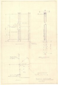 Falls Creek Historical Society
Plan - Diagram of Turnstile for New Chairlift
... . It is a detailed plan, including elevation, detail of pivot and the general... elevation, detail of pivot and the general arrangement views ...Bob (Herman) Hymans (a former member of the Royal Netherlands Navy was born in Bloemendaal, Holland on 30th September 1922. During World War II he fought against the Japanese in the Dutch East Indies (now Indonesia) and was imprisoned in Changi and on the Burma Railway. After gaining qualifications as a Ski Instructor, Bob arrived in Falls Creek in May 1950. Working as an Instructor and Supervisor at Bogong Lodge, Bob decided his future was in accommodation. He was successful in negotiating an indenture for land from the State Electricity Commission (SEC). It took Bob two years to build his Grande Coeur Chalet but, tragically, it was burned down in August 1961. Bob also built the first Chairlift in Australia. This was a single chairlift and the structure was built from wooden electricity poles. He was constantly full of new ideas and proposals for the village. Bob Hymans died on 7th May 2007. This Collection of documents and letters tells the story of Bob’s endeavours to develop Falls Creek into the ski village it is today. This map is significant because it documents plans made by Bob Hymans for Falls CreekThis diagram is part of Bob Hymans documents. It is a detailed plan, including elevation, detail of pivot and the general arrangement views of a turnstile. This is part of overall plans for the construction of a new chairlift at Falls Creek. At bottom of diagrams: PLAN TURNSTILE/ GENERAL ARRANGEMENT Scale 1 1/2" = 1'- 0"map of falls creek, falls creek leases, falls creek 1980s -
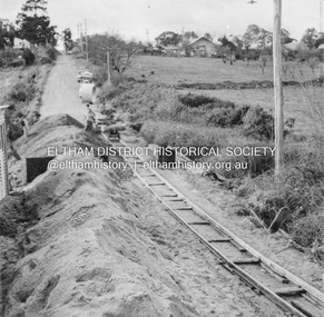 Eltham District Historical Society Inc
Album - Photograph, J.A. McDonald, Eltham-Greensborough Road, July 1956
... Diamond Creek Bridge (Bridge Street Bridge) General view... melbourne Diamond Creek Bridge (Bridge Street Bridge) General view ...Diamond Creek Bridge (Bridge Street Bridge) General view looking to Main Road View looking east up Bridge Street to Main Road prior to widening. The Eltham Obelisk is located at the top of the hill on the left but was relocated to the Eltham RSL front garden as a reesult of road widening works and improvements to the intersection. On the immediate right is the present-day Eltham Rugby Union ovalRecord of various Shire of Eltham infrastructure works undertaken during the period of 1952-1962 involving bridge and road reconstruction projects, sometimes with Eltham Shire Council Project Reference numbers quoted. It was during this period that a number of significant improvements were made to roads and new bridges constructed within the shire that remain in place as of present day (2022). In many situations, the photos provide a tangible visible record of infrastructure that existed throughout the early days of the Shire. The album was put together by or under the direction of the Shire Engineer, J.A. McDonald.infrastructure, road construction, shire of eltham, bridge construction, bridge street bridge, eltham, eltham-greensborough road, 1956-07 -
 Kiewa Valley Historical Society
Set of 6 framed photographs - Kiewa Hydro Electric Scheme
... 2. Junction Dam - General View from Downstream - May 1943 3... to Anchor 5. August 1955 2. Junction Dam - General View from ...Official photo of KHES constructed by SECVOfficial photo of KHES in the Kiewa Valley1. No. 1 Pipeline - from Anchor 1 to Anchor 5. August 1955 2. Junction Dam - General View from Downstream - May 1943 3. No. 3 Power Station - Clover Flat Camp - February 1951 4. Clover Dam - October 1954 5. View from Downstream of Junction Dam - July 1943 6. Upper Kiewa Valley Road 3 to 4 Mile - Mt Arthur in Background - July 1954 khes, secv -
 Bendigo Historical Society Inc.
Photograph - PHOTOCOPIES OF POSTCARDS: BENDIGONIAN HARGREAVES ST., MITCHELL ST., CITY MARKET, BAWCEN'S DRAPERY
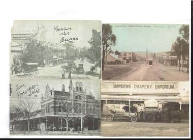
... building. General view of Mitchell Street, Bendigo, circa 1900..., Vic. Image shows horses and carts, Faul building. General view ...Photocopies: on one page, four cards. Bendigonian Series - In Hargreaves Street, Bendigo, Vic. Image shows horses and carts, Faul building. General view of Mitchell Street, Bendigo, circa 1900., Bendigonian Series, City Market Buildings, Bendigo, Vic. (? ) Bawdens Drapery Emporium - outside building D. Fletcher-Jones- Millinery Van -The Western district Travelling Draper , written on van ,There is a horse and cart which has a sign - D. Fletcher Jones, Travelling Draper.-bendigo, streetscape, mitchell, hargreaves st., bendigo, mitchell street, hargreave street, bawdens, faul. -
 Melbourne Tram Museum
Photograph - Set of 3 Colour Print/s, Colin Rough, 27/01/2002 12:00:00 AM
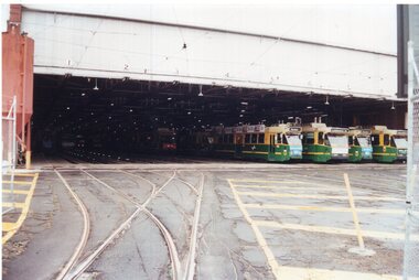
... .1 - General view across the yard with Z3 and B class trams... Depot. 27/1/2002 .1 - General view across the yard with Z3 ...Set of three Colour prints of Brunswick Depot. 27/1/2002 .1 - General view across the yard with Z3 and B class trams (appear to be 2006 and 2098) .2 - View with Z3 129 on the grinder siding and other trams in the background. Has the Depot Allocation Screen showing the location for tram 183. .3 - Looking north along Cameron St, with Z3 183 with the destination Moreland, running in. In the background is the Upfield Railway line. Photos shows the two signals in the street.On rear in ink "Brunswick Depot Melbourne 27/1/02" and (Col's 1st Aussie job) M&MTB 27/1/02"trams, tramways, brunswick depot, z3 class, b class, moreland, cameron st, signals, tram 129, tram 2006, tram 2098, tram 183 -
 University of Melbourne, Burnley Campus Archives
Photograph - Black and white print, Publicity Branch Victorian Department of Agriculture, Students Working in Orchard, 1964
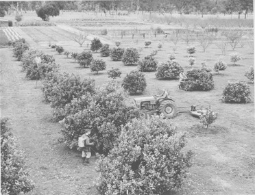
... (1964) B93.655 with caption "A general view of the orchard... in article by T H Kneen (1964) B93.655 with caption "A general view ...Note by T.H. Kneen 8 April 1992, "Operator on tractor could be Alan McLennan (Garden Instructor 1954-1969.) The citrus planting was established by Ray Harding (Dec 1958) therefore 1954-58. Students (3) not clear." Appears in article by T H Kneen (1964) B93.655 with caption "A general view of the orchard and vegetable garden at Burnley. The grass sward in the foreground is controlled by mechanical mowing and chemical weedicides."2 copies black and white photograph, one an enlargement. 3 students working in the Citrus Block of the Orchard. One is spraying from a backpack, one is mowing using a tractor and one is pruning.On reverse, "Photograph by Publicity Branch Department Of Agriculture Ref. No. D572B."alan mclennan, garden instructor, ray harding, burnley gardens, citrus trees, students working outside, orchard, tractor, spraying, mowing, pruning, publicity -
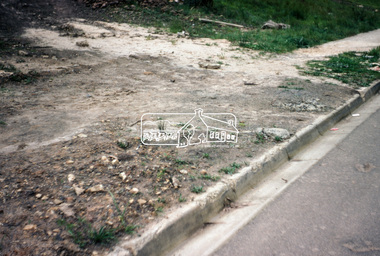
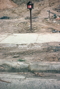
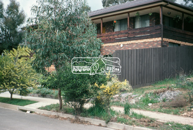
 Eltham District Historical Society Inc
Photograph, Kerb and channeling works, Beard Street and Main Road, Eltham, 3 Sep 1981
... to footpaths and gutters and general views of Beard Street... to footpaths and gutters and general views of Beard Street ...Roll of film taken by Eltham Shire Council officers of roads and houses in the Eltham East area, 3 September 1981 prior to construction of new water main; including views of existing damage to footpaths and gutters and general views of Beard Street. These images provide a perspective of housing estate developments and changes in housing styles and road development which began sweeping in from the mid 1970s with increasing urbanisation of what was once more outlying suburbs and regions.35mm colour positive transparency (1 of 28) Mount - Kodak Kodachrome Cardbeard street, eltham, footpaths and gutters, infrastructure, roads, main road -
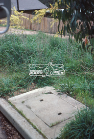
 Eltham District Historical Society Inc
Photograph, Beard Street, Eltham, 3 Sep 1981
... to footpaths and gutters and general views of Beard Street... to footpaths and gutters and general views of Beard Street ...Roll of film taken by Eltham Shire Council officers of roads and houses in the Eltham East area, 3 September 1981 prior to construction of new water main; including views of existing damage to footpaths and gutters and general views of Beard Street. These images provide a perspective of housing estate developments and changes in housing styles and road development which began sweeping in from the mid 1970s with increasing urbanisation of what was once more outlying suburbs and regions.35mm colour positive transparency (1 of 28) Mount - Kodak Kodachrome Cardbeard street, eltham, infrastructure, roads, horse, park road -
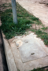
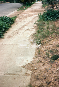
 Eltham District Historical Society Inc
Photograph, Foothpath and kerb damage, Bainbridge Drive, Eltham, 3 Sep 1981
... to footpaths and gutters and general views of Beard Street... to footpaths and gutters and general views of Beard Street ...Roll of film taken by Eltham Shire Council officers of roads and houses in the Eltham East area, 3 September 1981 prior to construction of new water main; including views of existing damage to footpaths and gutters and general views of Beard Street. These images provide a perspective of housing estate developments and changes in housing styles and road development which began sweeping in from the mid 1970s with increasing urbanisation of what was once more outlying suburbs and regions.35mm colour positive transparency (1 of 28) Mount - Kodak Kodachrome Cardeltham, infrastructure, roads, bainbridge drive, footpaths and gutters -
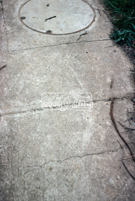
 Eltham District Historical Society Inc
Photograph, Foothpath and kerb damage, Madine Way, Eltham, 3 Sep 1981
... to footpaths and gutters and general views of Beard Street... to footpaths and gutters and general views of Beard Street ...Roll of film taken by Eltham Shire Council officers of roads and houses in the Eltham East area, 3 September 1981 prior to construction of new water main; including views of existing damage to footpaths and gutters and general views of Beard Street. These images provide a perspective of housing estate developments and changes in housing styles and road development which began sweeping in from the mid 1970s with increasing urbanisation of what was once more outlying suburbs and regions.35mm colour positive transparency (1 of 28) Mount - Kodak Kodachrome Cardeltham, infrastructure, roads, footpaths and gutters, madine way -
 Eltham District Historical Society Inc
Photograph, Madine Way, Eltham, 3 Sep 1981
... to footpaths and gutters and general views of Beard Street... to footpaths and gutters and general views of Beard Street ...Roll of film taken by Eltham Shire Council officers of roads and houses in the Eltham East area, 3 September 1981 prior to construction of new water main; including views of existing damage to footpaths and gutters and general views of Beard Street. These images provide a perspective of housing estate developments and changes in housing styles and road development which began sweeping in from the mid 1970s with increasing urbanisation of what was once more outlying suburbs and regions.35mm colour positive transparency (1 of 28) Mount - Kodak Kodachrome Cardeltham, infrastructure, roads, madine way, tadema park -
 Eltham District Historical Society Inc
Photograph, Beard Street, Eltham, 3 Sep 1981
... to footpaths and gutters and general views of Beard Street... to footpaths and gutters and general views of Beard Street ...Roll of film taken by Eltham Shire Council officers of roads and houses in the Eltham East area, 3 September 1981 prior to construction of new water main; including views of existing damage to footpaths and gutters and general views of Beard Street. These images provide a perspective of housing estate developments and changes in housing styles and road development which began sweeping in from the mid 1970s with increasing urbanisation of what was once more outlying suburbs and regions.35mm colour positive transparency (1 of 28) Mount - Kodak Kodachrome Cardeltham, infrastructure, roads, beard street, frank street, shalbury avenue -
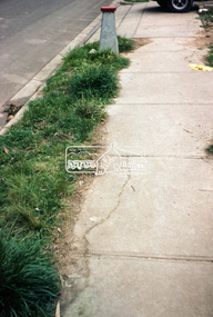
 Eltham District Historical Society Inc
Photograph, Beard Street, Eltham, 3 Sep 1981
... to footpaths and gutters and general views of Beard Street... to footpaths and gutters and general views of Beard Street ...Roll of film taken by Eltham Shire Council officers of roads and houses in the Eltham East area, 3 September 1981 prior to construction of new water main; including views of existing damage to footpaths and gutters and general views of Beard Street. These images provide a perspective of housing estate developments and changes in housing styles and road development which began sweeping in from the mid 1970s with increasing urbanisation of what was once more outlying suburbs and regions.35mm colour positive transparency (1 of 28) Mount - Kodak Kodachrome Cardeltham, infrastructure, roads, beard street -
 Eltham District Historical Society Inc
Photograph, Beard Street, Eltham, 3 Sep 1981
... to footpaths and gutters and general views of Beard Street... to footpaths and gutters and general views of Beard Street ...Roll of film taken by Eltham Shire Council officers of roads and houses in the Eltham East area, 3 September 1981 prior to construction of new water main; including views of existing damage to footpaths and gutters and general views of Beard Street. These images provide a perspective of housing estate developments and changes in housing styles and road development which began sweeping in from the mid 1970s with increasing urbanisation of what was once more outlying suburbs and regions.35mm colour positive transparency (1 of 28) Mount - Kodak Kodachrome Cardeltham, infrastructure, roads, beard street, frank street -
 Eltham District Historical Society Inc
Photograph, Beard Street, Eltham, 3 Sep 1981
... to footpaths and gutters and general views of Beard Street... to footpaths and gutters and general views of Beard Street ...Roll of film taken by Eltham Shire Council officers of roads and houses in the Eltham East area, 3 September 1981 prior to construction of new water main; including views of existing damage to footpaths and gutters and general views of Beard Street. These images provide a perspective of housing estate developments and changes in housing styles and road development which began sweeping in from the mid 1970s with increasing urbanisation of what was once more outlying suburbs and regions.35mm colour positive transparency (1 of 28) Mount - Kodak Kodachrome Cardeltham, infrastructure, roads, beard street, frank street