Showing 151 items
matching harbour beach
-
 Glenelg Shire Council Cultural Collection
Photograph - Photograph - Portland Harbour, Aug-89
Port of Portland Authority ArchivesBack: 'Land slip and infill Yacht Club / Henty Beach area August 89' black biroport of portland archives -
Glenelg Shire Council Cultural Collection
Photograph - Photograph - Lee Breakwater, Portland, n.d
Port of Portland Authority Archivesport of portland archives, lee breakwater, nuns beach, k s anderson wharf, harbour, construction -
Glenelg Shire Council Cultural Collection
Photograph - Photograph - Main Breakwater construction, Portland, 04/12/1952
Port of Portland Authority ArchivesFront: MAIN BREAKWATER ACCESS ROAD 4.12.52 TRUST WORKS HOUSES IN BACKGROUND - Blackprint. Back: Square purple stamp - Print No 4/9 Neg No 81 Date Taken 4.12.52 Subjectport of portland archives, main breakwater, construction, portland, harbour, harbour development -
Glenelg Shire Council Cultural Collection
Photograph - Photograph - Early Shipping: Ocean/Railway Pier, n.d
Port of Portland Authority ArchivesFront: back- ' View from old pier'- black ink Purple stamp- 'J66' Kodak Printport of portland archives, portland harbour -
Glenelg Shire Council Cultural Collection
Photograph - Photograph - Early Shipping: Ocean/Railway Pier, n.d
Port of Portland Authority ArchivesFront: Back- 10/10- Ink Purple PHT Stampport of portland archives, portland harbour, oil tanker berthed, nuns beach, ocean pier -
 Flagstaff Hill Maritime Museum and Village
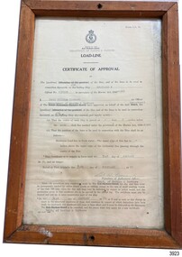
Document - Certificate of Approval, Load Line, 25-02-1970
This Certificate, Load-Line, gave approval for the vessel Reginald M to load cargo up to a certain line, marked by a disc attached to the ship and inspected by the South Australian Harbors Board. The vessel had a long and varied life of service. This Certificate relates to early 1970, before the ship was sold to the Lyall Mining and Rail Company. The Load Line on the Reginald M was carved on the ship, inside the hull and not removeable. The REGINALD M - The vessel “Reginald M” was a two-masted coastal ketch, owned and built by Mr. Jack (John) Murch of Birkenhead, Port of Adelaide, South Australia. Its construction took approximately 6 months and it was launched at Largs Bay in 1922. The Reginald M’s purpose was to serve the coastal trade of South Australia, to carry cargo cheaply and efficiently. It is believed that the keel was in fact hewn from two telegraph poles! Its builder frequented all the salvage yards for materials and fittings. Reginald M had a very shallow draft and a flat bottom that enabled it to come close to shore and to sit high and dry at low tide or to be beached on sand. The flat bottom was also to make the ship able to skim over reefs. Wagons could load and unload direct from her side. Her cargo included Guano, Barley, Wool, Horses, Cattle, Timber, Explosives, Potatoes, Shell Grit and Gypsum. After a variety of services, in late 1970 Reginald M was sold to the Mt. Lyell Mining and Railway Company and was used by them as a barge to carry explosives. In 1972 the Navy League of Strahan, Tasmania, purchased her for use by the Strahan Sea Cadet Unit to use at Macquarie Harbour and renamed her T.S. Macquarie. However this plan for use of Reginald M did not come to pass. In 1974 Mr. Andrew Rennie, of East Brighton, Melbourne, bought her for a similar purpose. , paying $5,000 and donating a ‘Cadet of the Year” trophy to the Sea Cadets. He sailed her from Strahan to Melbourne, planning to use her for pleasure sailing. Also in 1975 Reginald M was sold to Melbourne Ferry Company at auction. Later in 1975 the Reginald M was bought by Flagstaff Maritime Museum for $20,000 . She has been restored and is now one of the exhibits in the Village lagoon or lake. It was restored in 2006 using funds from a $4,000 government grant.This Certificate is significant because of its association with the last working days of REGINALD M. REGNIALD M was a coastal trading ketch from South Australia built in 1922. It was one of very few sailing coastal trading vessels still existing until 2016, and its flat bottom, single chine shape illustrated a very simple but robust method of construction, compared to other round bilged examples of trading vessels. The vessel is listed on the Australian Register of Historic Vessels (ARHV Number: HV000562.)Certificate, rectangular, behind glass in wooden frame. Certificate is an official printed form, some information is over-typed, other information is hand written and signed. Frame has a central hole in top and bottom. The Certificate relates to Load Level of the vessel Reginald M and refers to the exact placement of a disc within the vessel that indicates the maximum load in fresh water. . Issued to the vessel 'Reginald M', Official Number 137228. . Issued by the Sough Australian Harbors Board . Valid from 25-02-1970 to 31-01-1974. . Signed by Neil Cormack, 25th February 1970Certificate of Approval - Load Line for sailing vessel Reginald M, Official Number 137228. Logo of the South Australian Harbors Board. Issued by Department of Marine & Harbors, Port Adelaide, 25th February 1970. In force until 31st January 1974. Signed by Neil William Cormack, authorised officer for Department of Marine & Harbors. Typed onto form: "AUX [SAILING SIP]" "REGINALD M" "137228" "1968" " Neil William Cormack" "Department of Marine & Harbors" "1 [foot] 3 [inches below the] main [deck]" "31st JANUARY 74" "25th FEBRUARY 70" Signature: "Neil W Cormack"flagstaff hill, warrnambool, maritime village, maritime museum, flagstaff hill maritime museum & village, shipwreck coast, great ocean road, coastal trader, reginald m, ketch, john murch, ch murch, reg webb, carribie station, mt lyell copper company, melbourne ferry company, certificate of approval, load line, 137228, load line disc, 25-02-1970, neil w cormack, neil william cormack, south australian harbors board, department of marine and harbors, harbours -
 Flagstaff Hill Maritime Museum and Village
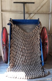
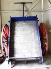
Vehicle - Beach cart and cover, Government of Victoria, 1860s
The beach cart was hand drawn by a team of six people; two in front, one on each side and two behind. The wide iron tyres on the the wheels helped prevent the cart from sinking into the sand. The load of heavy beach apparatus equipment was held in place by the hand worked rope net cover. It would be stored in the Rocket House packed and ready to use for practice or rescue. Beach apparatus equipment - In the mid-1800s the equipment could include a line throwing set, coiled line in wooden carrying case, rockets, cartridges, breeches buoy, hawser and traveller block, line-throwing pistol, beach cart, hand barrow, sand anchor, crotch pole, and tools such as spade, pick, mallet and hawser cutter. Around the 1860s Warrnambool had a Rocket House installed beside the Harbour. Saving lives in Warrnambool – The coastline of South West Victoria is the site of over 600 shipwrecks and many lost lives; even in Warrnambool’s Lady Bay there were around 16 known shipwrecks between 1850 and 1905, with eight lives lost. Victoria’s Government responded to the need for lifesaving equipment and, in 1858, the provision of rocket and mortar apparatus was approved for the lifeboat stations. In 1859 the first Government-built lifeboat arrived at Warrnambool Harbour and a shed was soon built for it on the Tramway Jetty, followed by a rocket house in 1864 to safely store the rocket rescue equipment. In 1878 the buildings were moved to the Breakwater (constructed from 1874-1890), and in 1910 the new Lifeboat Warrnambool arrived with its ‘self-righting’ design. For almost a hundred years the lifesaving and rescue crews, mostly local volunteers, trained regularly to rehearse and maintain their rescue skills. They were summoned when needed by alarms, gunshots, ringing bells and foghorns. In July 1873 a brass bell was erected at Flagstaff Hill specifically to call the rescue crew upon news of a shipwreck. Some crew members became local heroes but all served an important role. Rocket apparatus was used as recently as the 1950s. This cart and cover set is significant for its connection with local history, maritime history and marine technology. Lifesaving has been an important part of the services performed from Warrnambool's very early days, supported by State and Local Government, and based on the methods and experience of Great Britain. Hundreds of shipwrecks along the coast are evidence of the rough weather and rugged coastline. Ordinary citizens, the Harbour employees, and the volunteer boat and rescue crew, saved lives in adverse circumstances. Some were recognised as heroes, others went unrecognised. In Lady Bay, Warrnambool, there were around 16 known shipwrecks between 1850 and 1905. Many lives were saved but tragically, eight lives were lost.Beach cart; a blue and white painted, wooden cart with two, red coloured metal wheels. The wheels have twelve spokes and wide iron tyres. The cart has a long draw bar with T- handles at the end. It was pulled by two people, usually steered by another two and pushed by a further two. It was supplied by the Government of Victoria. There is an inscription on the front end panel. The cart has a removable hand worked rope cover. Stencilled in white paint “G of V” flagstaff hill, warrnambool, maritime village, maritime museum, shipwreck coast, great ocean road, flagstaff hill maritime museum and village, lady bay, warrnambool harbour, port of warrnambool, shipwreck, life-saving, lifesaving, rescue crew, rescue, rocket rescue, rocket crew, beach rescue, rescue equipment, rocket rescue equipment, rocket equipment, marine technology, lifeboat, volunteer lifesavers, volunteer crew, lifesaving rescue crew, rocket apparatus, shore to ship, stranded vessel, rocket rescue apparatus, line thrower, beach apparatus, breeches buoy, life jacket, rocket house, rocket shed, rocket machine, rocket head, rocket launcher, rocket line, beach rescue set, rocket set, beach cart, hand barrow, welsh hand barrow, harbour board, government of victoria, harbour master, l.s.r.c., lsrc -
 Flagstaff Hill Maritime Museum and Village
Vehicle - Beach Cart, Government of Victoria, 1860s
... line beach rescue set rocket set beach cart Harbour Board ...The beach cart was hand drawn by a team of six people; two in front, one on each side and two behind. The wide iron tyres on the the wheels helped prevent the cart from sinking into the sand. The load of heavy beach apparatus equipment was held in place by a separate hand worked rope net cover. It would be stored in the Rocket House packed and ready to use for practice or rescue. Beach apparatus equipment - In the mid-1800s the equipment could include a line throwing set, coiled line in wooden carrying case, rockets, cartridges, breeches buoy, hawser and traveller block, line-throwing pistol, beach cart, hand barrow, sand anchor, crotch pole, and tools such as spade, pick, mallet and hawser cutter. Around the 1860s Warrnambool had a Rocket House installed beside the Harbour. Saving lives in Warrnambool – The coastline of South West Victoria is the site of over 600 shipwrecks and many lost lives; even in Warrnambool’s Lady Bay there were around 16 known shipwrecks between 1850 and 1905, with eight lives lost. Victoria’s Government responded to the need for lifesaving equipment and, in 1858, the provision of rocket and mortar apparatus was approved for the lifeboat stations. In 1859 the first Government-built lifeboat arrived at Warrnambool Harbour and a shed was soon built for it on the Tramway Jetty, followed by a rocket house in 1864 to safely store the rocket rescue equipment. In 1878 the buildings were moved to the Breakwater (constructed from 1874-1890), and in 1910 the new Lifeboat Warrnambool arrived with its ‘self-righting’ design. For almost a hundred years the lifesaving and rescue crews, mostly local volunteers, trained regularly to rehearse and maintain their rescue skills. They were summoned when needed by alarms, gunshots, ringing bells and foghorns. In July 1873 a brass bell was erected at Flagstaff Hill specifically to call the rescue crew upon news of a shipwreck. Some crew members became local heroes but all served an important role. Rocket apparatus was used as recently as the 1950s. This cart and its matching cover is significant for its connection with local history, maritime history and marine technology. Lifesaving has been an important part of the services performed from Warrnambool's very early days, supported by State and Local Government, and based on the methods and experience of Great Britain. Hundreds of shipwrecks along the coast are evidence of the rough weather and rugged coastline. Ordinary citizens, the Harbour employees, and the volunteer boat and rescue crew, saved lives in adverse circumstances. Some were recognised as heroes, others went unrecognised. In Lady Bay, Warrnambool, there were around 16 known shipwrecks between 1850 and 1905. Many lives were saved but tragically, eight lives were lost.Beach cart; a blue and white painted, wooden cart with two, red coloured metal wheels. The wheels have twelve spokes and wide iron tyres. The cart has a long draw bar with T- handles at the end. It was pulled by two people, usually steered by another two and pushed by a further two. It was supplied by the Government of Victoria. There is an inscription on the front end panel.Stencilled in white paint “G of V” flagstaff hill, warrnambool, maritime village, maritime museum, shipwreck coast, great ocean road, flagstaff hill maritime museum and village, lady bay, warrnambool harbour, port of warrnambool, shipwreck, life-saving, lifesaving, rescue crew, rescue, rocket rescue, rocket crew, beach rescue, rescue equipment, rocket rescue equipment, rocket equipment, marine technology, lifeboat, volunteer lifesavers, volunteer crew, lifesaving rescue crew, rocket apparatus, shore to ship, stranded vessel, rocket rescue apparatus, line thrower, beach apparatus, breeches buoy, life jacket, rocket house, rocket shed, rocket machine, rocket head, rocket launcher, rocket line, beach rescue set, rocket set, beach cart, harbour board, government of victoria, harbour master, l.s.r.c., lsrc, rope cover, rope net -
 Flagstaff Hill Maritime Museum and Village
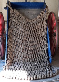
Equipment - Beach cart cover, Government of Victoria, 1860s
The load of heavy beach apparatus life saving equipment was held in place on the beach cart by the hand worked rope net cover. It would be stored in the Rocket House packed and ready to use for practice or rescue. Beach apparatus equipment - In the mid-1800s the equipment could include a line throwing set, coiled line in wooden carrying case, rockets, cartridges, breeches buoy, hawser and traveller block, line-throwing pistol, beach cart, hand barrow, sand anchor, crotch pole, and tools such as spade, pick, mallet and hawser cutter. Around the 1860s Warrnambool had a Rocket House installed beside the Harbour. Saving lives in Warrnambool – The coastline of South West Victoria is the site of over 600 shipwrecks and many lost lives; even in Warrnambool’s Lady Bay there were around 16 known shipwrecks between 1850 and 1905, with eight lives lost. Victoria’s Government responded to the need for lifesaving equipment and, in 1858, the provision of rocket and mortar apparatus was approved for the lifeboat stations. In 1859 the first Government-built lifeboat arrived at Warrnambool Harbour and a shed was soon built for it on the Tramway Jetty, followed by a rocket house in 1864 to safely store the rocket rescue equipment. In 1878 the buildings were moved to the Breakwater (constructed from 1874-1890), and in 1910 the new Lifeboat Warrnambool arrived with its ‘self-righting’ design. For almost a hundred years the lifesaving and rescue crews, mostly local volunteers, trained regularly to rehearse and maintain their rescue skills. They were summoned when needed by alarms, gunshots, ringing bells and foghorns. In July 1873 a brass bell was erected at Flagstaff Hill specifically to call the rescue crew upon news of a shipwreck. Some crew members became local heroes but all served an important role. Rocket apparatus was used as recently as the 1950s. This cover was used with the beach cart. The cart is significant for its connection with local history, maritime history and marine technology. Lifesaving has been an important part of the services performed from Warrnambool's very early days, supported by State and Local Government, and based on the methods and experience of Great Britain. Hundreds of shipwrecks along the coast are evidence of the rough weather and rugged coastline. Ordinary citizens, the Harbour employees, and the volunteer boat and rescue crew, saved lives in adverse circumstances. Some were recognised as heroes, others went unrecognised. In Lady Bay, Warrnambool, there were around 16 known shipwrecks between 1850 and 1905. Many lives were saved but tragically, eight lives were lost.Rectangular rope cover, hand worked for the purpose of covering the beach cart. The cover is made from heavy rope in a pattern that looks similar to crochet. A loop has been worked into each corner.flagstaff hill, warrnambool, maritime village, maritime museum, shipwreck coast, great ocean road, flagstaff hill maritime museum and village, lady bay, warrnambool harbour, port of warrnambool, shipwreck, life-saving, lifesaving, rescue crew, rescue, rocket rescue, rocket crew, beach rescue, rescue equipment, rocket rescue equipment, marine technology, lifeboat, volunteer lifesavers, volunteer crew, lifesaving rescue crew, rocket apparatus, stranded vessel, rocket rescue apparatus, beach apparatus, life jacket, rocket shed, rocket line, beach rescue set, rocket set, beach cart, hand barrow, welsh hand barrow, harbour board, government of victoria, harbour master, l.s.r.c., lsrc, rocket house -
 Flagstaff Hill Maritime Museum and Village
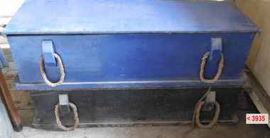
Equipment - Line faking box, Government of Victoria, 1860s
The rocket line faking box with lid has a frame inside with a specifically designed perimeter of faking pegs. The rocket shot line has been faked, or skilful wound, around these pegs to prevent it from tangling. The line is stored in the box, ready for attaching to the line throwing rocket. Some line faking boxes have a false base that is removed before firing the line-throwing pistol, leaving the line to feed out from the box when the rocket is fired. After the line is attached to the rocket the box tilted slightly and faced towards the wreck to allow it to be freely dispatched. The equipment often includes more that one faking box to make allowance for possible errors, broken lines or the need for a heavier line. Saving lives in Warrnambool – The coastline of South West Victoria is the site of over 600 shipwrecks and many lost lives; even in Warrnambool’s Lady Bay there were around 16 known shipwrecks between 1850 and 1905, with eight lives lost. In 1859 the first Government-built lifeboat arrived at Warrnambool Harbour and a shed was soon built to house it. In 1858 the provision of rocket and mortar apparatus was approved for lifeboat stations in Victoria, and in 1864 a rocket house was built to safely store the rocket rescue equipment. In 1878 the buildings were moved to the Breakwater area, and in 1910 the new Lifeboat Warrnambool arrived with its ‘self-righting’ design. For almost a hundred years the lifeboat and rocket crews, mostly local volunteers, trained regularly to maintain their rescue skills. They were summoned when needed by alarms, gunshots, ringing bells and foghorns. Some became local heroes but all served an important role. By the end of the 1950s the lifeboat and rescue equipment had become obsolete. Rocket Rescue Method - The Government of Victoria adopted lifesaving methods based on Her Majesty’s Coast Guard in Great Britain. It authorised the first line-throwing rescue system in 1858. Captain Manby’s mortar powered a projectile connected to rope, invented in 1808. The equipment was updated to John Dennett’s 8-foot shaft and rocket method that had a longer range of about 250 yards. From the 1860s the breeches buoy and traveller block rocket rescue apparatus was in use. It was suspended on a hawser line and manually pulled to and from the distressed vessel carrying passengers and items. In the early 1870s Colonel Boxer’s rocket rescue method became the standard in Victoria. His two-stage rockets, charged by a gunpowder composition, could fire the line up to 500-600 yards, although 1000 yards range was possible. Boxer’s rocket carried the light line, which was faked, or coiled, in a particular way between pegs in a faking box to prevent twists and tangles when fired. The angle of firing the rocket to the vessel in distress was measured by a quadrant-type instrument on the side of the rocket machine. Decades later, in about 1920, Schermuly invented the line-throwing pistol that used a small cartridge to fire the rocket. The British Board of Trade published instructions for both the beach rescue crew and ship’s crew. It involved setting up the rocket launcher on shore at a particular angle measured by the quadrant, inserting a rocket that had a light-weight line threaded through its shaft, and then firing it across the stranded vessel, the line issuing freely from the faking board. A tally board was then sent out to the ship with instructions in four languages. The ship’s crew would haul on the line to bring out the heavier, continuous whip line, then secure the attached whip block to the mast or other sturdy part the ship. The rescue crew on shore then hauled out a stronger hawser line, which the ship’s crew fixed above the whip block. The hawser was then tightened using the block on the shore end of the whip. The breeches buoy and endless whip are then attached to the traveller block on the hawser, allowing the shore crew to haul the breeches buoy to and from the vessel, rescuing the stranded crew one at a time. This rocket line faking box is significant for its connection with local history, maritime history and marine technology. Lifesaving has been an important part of the services performed from Warrnambool's very early days, supported by State and Local Government, and based on the methods and experience of Great Britain. Hundreds of shipwrecks along the coast are evidence of the rough weather and rugged coastline. Ordinary citizens, the Harbour employees, and the volunteer boat and rescue crew, saved lives in adverse circumstances. Some were recognised as heroes, others went unrecognised. In Lady Bay, Warrnambool, there were around 16 known shipwrecks between 1850 and 1905. Many lives were saved but tragically, eight lives were lost.Rocket line faking box with loose fitting lid, painted blue on the outside. Rectangular box has two rope handles within wooden rope holders fixed onto each long side and one at each end. The box has a hook and ring at the base each end for releasing the top from the inserted faking frame. The line faking frame is inside the box. It has seventeen wooden pegs along each long side of the frame and three pegs along each short side. A continuous length of rocket line has been faked around the pegs in a specific pattern.flagstaff hill maritime museum & village, flagstaff hill, maritime museum, maritime village, warrnambool, great ocean road, shipwreck, life-saving, lifesaving, rescue crew, rescue, rocket rescue, maritime accidents, rocket crew, beach rescue, line rescue, rescue equipment, rocket firing equipment, rocket rescue equipment, rocket apparatus, beach apparatus, petticoat breeches, breeches buoy, rocket house, rocket shed, lifeboat men, rocket equipment, rocket machine, rocket head, rocket launcher, rocket line, marine technology, line-firing pistol, line throwing gun, beach rescue set, traveller, hawser, faking, faking box, faked line, lady bay, warrnambool harbour, port of warrnambool, volunteer lifesavers, volunteer crew, breakwater, lifeboat warrnambool, rocket rescue method, rocket rescue apparatus, shore to ship, italian hemp, line-throwing pistol, line throwing cartridge, rocket apparatus rescue, stranded vessel, tally board, light line, whip line, endless whip, petticoat buoy, traveller chair, traveller block, her majesty’s coast guard, harbour board, line thrower, line throwing, beach cart, hand barrow, sand anchor, hawser cutter, life jacket, faking board, welsh hand barrow, rocket set, rocket line faking box, faking frame -
 Flagstaff Hill Maritime Museum and Village
Equipment - Line faking box, Government of Victoria, 1860s
The rocket line faking box has a frame inside with a specifically designed perimeter of faking pegs. The rocket shot line has been faked, or skilful wound, around these pegs to prevent it from tangling. The line is stored in the box, ready for attaching to the line throwing rocket. Some line faking boxes have a false base that is removed before firing the line-throwing pistol, leaving the line to feed out from the box when the rocket is fired. After the line is attached to the rocket the box tilted slightly and faced towards the wreck to allow it to be freely dispatched. The equipment often includes more that one faking box to make allowance for possible errors, broken lines or the need for a heavier line. Saving lives in Warrnambool – The coastline of South West Victoria is the site of over 600 shipwrecks and many lost lives; even in Warrnambool’s Lady Bay there were around 16 known shipwrecks between 1850 and 1905, with eight lives lost. In 1859 the first Government-built lifeboat arrived at Warrnambool Harbour and a shed was soon built to house it. In 1858 the provision of rocket and mortar apparatus was approved for lifeboat stations in Victoria, and in 1864 a rocket house was built to safely store the rocket rescue equipment. In 1878 the buildings were moved to the Breakwater area, and in 1910 the new Lifeboat Warrnambool arrived with its ‘self-righting’ design. For almost a hundred years the lifeboat and rocket crews, mostly local volunteers, trained regularly to maintain their rescue skills. They were summoned when needed by alarms, gunshots, ringing bells and foghorns. Some became local heroes but all served an important role. By the end of the 1950s the lifeboat and rescue equipment had become obsolete. Rocket Rescue Method - The Government of Victoria adopted lifesaving methods based on Her Majesty’s Coast Guard in Great Britain. It authorised the first line-throwing rescue system in 1858. Captain Manby’s mortar powered a projectile connected to rope, invented in 1808. The equipment was updated to John Dennett’s 8-foot shaft and rocket method that had a longer range of about 250 yards. From the 1860s the breeches buoy and traveller block rocket rescue apparatus was in use. It was suspended on a hawser line and manually pulled to and from the distressed vessel carrying passengers and items. In the early 1870s Colonel Boxer’s rocket rescue method became the standard in Victoria. His two-stage rockets, charged by a gunpowder composition, could fire the line up to 500-600 yards, although 1000 yards range was possible. Boxer’s rocket carried the light line, which was faked, or coiled, in a particular way between pegs in a faking box to prevent twists and tangles when fired. The angle of firing the rocket to the vessel in distress was measured by a quadrant-type instrument on the side of the rocket machine. Decades later, in about 1920, Schermuly invented the line-throwing pistol that used a small cartridge to fire the rocket. The British Board of Trade published instructions for both the beach rescue crew and ship’s crew. It involved setting up the rocket launcher on shore at a particular angle measured by the quadrant, inserting a rocket that had a light-weight line threaded through its shaft, and then firing it across the stranded vessel, the line issuing freely from the faking board. A tally board was then sent out to the ship with instructions in four languages. The ship’s crew would haul on the line to bring out the heavier, continuous whip line, then secure the attached whip block to the mast or other sturdy part the ship. The rescue crew on shore then hauled out a stronger hawser line, which the ship’s crew fixed above the whip block. The hawser was then tightened using the block on the shore end of the whip. The breeches buoy and endless whip are then attached to the traveller block on the hawser, allowing the shore crew to haul the breeches buoy to and from the vessel, rescuing the stranded crew one at a time. This rocket line faking box is significant for its connection with local history, maritime history and marine technology. Lifesaving has been an important part of the services performed from Warrnambool's very early days, supported by State and Local Government, and based on the methods and experience of Great Britain. Hundreds of shipwrecks along the coast are evidence of the rough weather and rugged coastline. Ordinary citizens, the Harbour employees, and the volunteer boat and rescue crew, saved lives in adverse circumstances. Some were recognised as heroes, others went unrecognised. In Lady Bay, Warrnambool, there were around 16 known shipwrecks between 1850 and 1905. Many lives were saved but tragically, eight lives were lost.Rocket line faking box with loose fitting lid, painted black on the outside. Rectangular box has two rope handles within wooden rope holders fixed onto each long side and one at each end. The box has a hook and ring at the base each end for releasing the top from the inserted faking frame. The line faking frame is inside the box. It has seventeen wooden pegs along each long side of the frame and three pegs along each short side. A continuous length of rocket line has been faked around the pegs in a specific pattern.flagstaff hill maritime museum & village, flagstaff hill, maritime museum, maritime village, warrnambool, great ocean road, shipwreck, life-saving, lifesaving, rescue crew, rescue, rocket rescue, maritime accidents, rocket crew, beach rescue, line rescue, rescue equipment, rocket firing equipment, rocket rescue equipment, rocket apparatus, beach apparatus, petticoat breeches, breeches buoy, rocket house, rocket shed, lifeboat men, rocket equipment, rocket machine, rocket head, rocket launcher, rocket line, marine technology, line-firing pistol, line throwing gun, beach rescue set, traveller, hawser, faking, faking box, faked line, lady bay, warrnambool harbour, port of warrnambool, volunteer lifesavers, volunteer crew, breakwater, lifeboat warrnambool, rocket rescue method, rocket rescue apparatus, shore to ship, italian hemp, line-throwing pistol, line throwing cartridge, rocket apparatus rescue, stranded vessel, tally board, light line, whip line, endless whip, petticoat buoy, traveller chair, traveller block, her majesty’s coast guard, harbour board, line thrower, line throwing, beach cart, hand barrow, sand anchor, hawser cutter, life jacket, faking board, welsh hand barrow, rocket set, rocket line faking box, faking frame -
 Flagstaff Hill Maritime Museum and Village
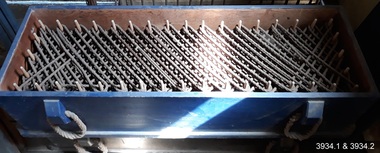
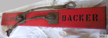
Equipment - Sand anchor, Mid-19th to mid-20th Century
The rocket rescue crews used a sand anchor at a beach rescue site to weigh down the rescue apparatus. The crew would connect the steel cables to the connecting cable and then join heavy ropes or chains to the connecting cable. They would then bury the anchor in a trench about three-quarters of a metre deep, keeping the connecting cable’s end free. The length of heavy rope or chain was attached to a pulley block onto the heavy hawser line. The block and a crotch pole were used to keep the hawser line high and taught, keeping the survivors above the sea as they were hauled to shore on a line or in a breeches buoy. Saving lives in Warrnambool – The coastline of South West Victoria is the site of over 600 shipwrecks and many lost lives; even in Warrnambool’s Lady Bay there were around 16 known shipwrecks between 1850 and 1905, with eight lives lost. In 1859 the first Government-built lifeboat arrived at Warrnambool Harbour and a shed was soon built to house it. In 1858 the provision of rocket and mortar apparatus was approved for lifeboat stations in Victoria, and in 1864 a rocket house was built to safely store the rocket rescue equipment. In 1878 the buildings were moved to the Breakwater area, and in 1910 the new Lifeboat Warrnambool arrived with its ‘self-righting’ design. For almost a hundred years the lifeboat and rocket crews, mostly local volunteers, trained regularly to maintain their rescue skills. They were summoned when needed by alarms, gunshots, ringing bells and foghorns. Some became local heroes but all served an important role. By the end of the 1950s, the lifeboat and rescue equipment had become obsolete. Rocket Rescue Method - The Government of Victoria adopted lifesaving methods based on Her Majesty’s Coast Guard in Great Britain. It authorised the first line-throwing rescue system in 1858. Captain Manby’s mortar powered a projectile connected to a rope, invented in 1808. The equipment was updated to John Dennett’s 8-foot shaft and rocket method that had a longer range of about 250 yards. From the 1860s the breeches buoy apparatus was in use. The apparatus was suspended on a hawser line and manually pulled to and from the distressed vessel carrying passengers and items. In the early 1870s Colonel Boxer’s rocket rescue method became the standard in Victoria. His two-stage rockets, charged by a gunpowder composition, could fire the line up to 500-600 yards, although 1000 yards range was possible. Boxer’s rocket carried the light line, which was faked, or coiled, in a particular way between pegs in a faking box to prevent twists and tangles when fired. The angle of firing the rocket to the vessel in distress was measured by a quadrant-type instrument on the side of the rocket machine. Decades later, in about 1920, Schermuly invented the line-throwing pistol that used a small cartridge to fire the rocket. The British Board of Trade published instructions for both the beach rescue crew and ship’s crew. It involved setting up the rocket launcher on shore at a particular angle measured by the quadrant, inserting a rocket that had a lightweight line threaded through its shaft, and then firing it across the stranded vessel, the line issuing freely from the faking board. A tally board was then sent out to the ship with instructions in four languages. The ship’s crew would haul on the line to bring out the heavier, continuous whip line, then secure the attached whip block to the mast or other sturdy part of the ship. The rescue crew on shore then hauled out a stronger hawser line, which the ship’s crew fixed above the whip block. The hawser was then tightened using the block on the shore end of the whip. The breeches buoy and endless whip are then attached to the traveller block on the hawser, allowing the shore crew to haul the breeches buoy to and from the vessel, rescuing the stranded crew one at a time. This sand anchor is part of the rocket rescue equipment and is significant for its connection with local history, maritime history and marine technology. Lifesaving has been an important part of the services performed from Warrnambool's very early days, supported by State and Local Government, and based on the methods and experience of Great Britain. Hundreds of shipwrecks along the coast are evidence of the rough weather and rugged coastline. Ordinary citizens, the Harbour employees, and the volunteer boat and rescue crew, saved lives in adverse circumstances. Some were recognised as heroes, others went unrecognised. In Lady Bay, Warrnambool, there were around 16 known shipwrecks between 1850 and 1905. Many lives were saved but tragically, eight lives were lost.The sand anchor comprises a plank with steel cables and a connecting cable. The rectangular wooden bevelled-edged plank with two pairs of square metal plates bolted through it. Each metal plate has an eyelet and the two steel cable lengths are permanently attached by their eyelets to the plates. The eyelets at each end of the cable lengths are reinforced with rope work and one length also has a ‘U’ bolt shackle connection. The steel connecting cable also has reinforced eyelets at both ends. The plank has a black stencilled inscription on the upper surface. Stencilled in black paint "ANCHOR" "BACKER"flagstaff hill maritime museum & village, flagstaff hill, maritime museum, maritime village, warrnambool, great ocean road, shipwreck, life-saving, lifesaving, rescue crew, rescue, rocket rescue, maritime accidents, shipwreck victim, rocket crew, beach rescue, line rescue, rescue equipment, rocket firing equipment, rocket rescue equipment, rocket apparatus, beach apparatus, breeches buoy, rocket house, rocket equipment, rocket launcher, rocket line, marine technology, beach rescue set, traveller, block, running block, pulley, hawser, faked line, lady bay, warrnambool harbour, port of warrnambool, volunteer lifesavers, volunteer crew, breakwater, rocket rescue method, rocket rescue apparatus, shore to ship, rocket apparatus rescue, stranded vessel, whip line, endless whip, harbour board, sand anchor, rocket set, anchor backer, rescue anchor, beach anchor, backer, anchor, steel cable, wire cable, connecting cable -
 Flagstaff Hill Maritime Museum and Village
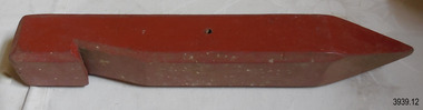
Equipment - Sand peg set, Mid-19th to mid-20th Century
This set of Victorian era wooden sand pegs was part of the equipment used by the Rocket Rescue Crew when attending a shipwreck. The broad pegs were designed to give a strong grip on soft sand and soil. The pegs could be used with the sand anchor as well as to give a stronger hold on the tripod holding the hawser. The same design is still available today and is used by the Army and by campers. The rocket rescue crews used a sand anchor at a beach rescue site to weigh down the rescue apparatus. The crew would connect the shackle to the other cable on the anchor and to the loose steel cable to form a triangle with the cable lengths. They would then bury the anchor in about a 0.75-meter trench, keeping the free end of the cable above the surface. This end of the cable was then connected to a block that was attached to the heavy hawser line. The block and a crotch pole were used to keep the hawser line high and taught as the survivors were hauled to shore on a line or in a breeches buoy. Saving lives in Warrnambool – The coastline of South West Victoria is the site of over 600 shipwrecks and many lost lives; even in Warrnambool’s Lady Bay there were around 16 known shipwrecks between 1850 and 1905, with eight lives lost. In 1859 the first Government-built lifeboat arrived at Warrnambool Harbour and a shed was soon built to house it. In 1858 the provision of rocket and mortar apparatus was approved for lifeboat stations in Victoria, and in 1864 a rocket house was built to safely store the rocket rescue equipment. In 1878 the buildings were moved to the Breakwater area, and in 1910 the new Lifeboat Warrnambool arrived with its ‘self-righting’ design. For almost a hundred years the lifeboat and rocket crews, mostly local volunteers, trained regularly to maintain their rescue skills. They were summoned when needed by alarms, gunshots, ringing bells and foghorns. Some became local heroes but all served an important role. By the end of the 1950s, the lifeboat and rescue equipment had become obsolete. Rocket Rescue Method - The Government of Victoria adopted lifesaving methods based on Her Majesty’s Coast Guard in Great Britain. It authorised the first line-throwing rescue system in 1858. Captain Manby’s mortar powered a projectile connected to a rope, invented in 1808. The equipment was updated to John Dennett’s 8-foot shaft and rocket method that had a longer range of about 250 yards. From the 1860s the breeches buoy apparatus was in use. The apparatus was suspended on a hawser line and manually pulled to and from the distressed vessel carrying passengers and items. In the early 1870s Colonel Boxer’s rocket rescue method became the standard in Victoria. His two-stage rockets, charged by a gunpowder composition, could fire the line up to 500-600 yards, although 1000 yards range was possible. Boxer’s rocket carried the light line, which was faked, or coiled, in a particular way between pegs in a faking box to prevent twists and tangles when fired. The angle of firing the rocket to the vessel in distress was measured by a quadrant-type instrument on the side of the rocket machine. Decades later, in about 1920, Schermuly invented the line-throwing pistol that used a small cartridge to fire the rocket. The British Board of Trade published instructions for both the beach rescue crew and ship’s crew. It involved setting up the rocket launcher on shore at a particular angle measured by the quadrant, inserting a rocket that had a lightweight line threaded through its shaft, and then firing it across the stranded vessel, the line issuing freely from the faking board. A tally board was then sent out to the ship with instructions in four languages. The ship’s crew would haul on the line to bring out the heavier, continuous whip line, then secure the attached whip block to the mast or other sturdy part of the ship. The rescue crew on shore then hauled out a stronger hawser line, which the ship’s crew fixed above the whip block. The hawser was then tightened using the block on the shore end of the whip. The breeches buoy and endless whip are then attached to the traveller block on the hawser, allowing the shore crew to haul the breeches buoy to and from the vessel, rescuing the stranded crew one at a time. This set of sand pegs would have been used with sand anchor that is part of the rocket rescue equipment . It is significant for its connection with local history, maritime history and marine technology. Lifesaving has been an important part of the services performed from Warrnambool's very early days, supported by State and Local Government, and based on the methods and experience of Great Britain. Hundreds of shipwrecks along the coast are evidence of the rough weather and rugged coastline. Ordinary citizens, the Harbour employees, and the volunteer boat and rescue crew, saved lives in adverse circumstances. Some were recognised as heroes, others went unrecognised. In Lady Bay, Warrnambool, there were around 16 known shipwrecks between 1850 and 1905. Many lives were saved but tragically, eight lives were lost.Peg or spike; set of twelve wooden pegs, painted red. Pages have a long, thick square shank with bevelled side edges, flat top with broad hook on one side of the top and a point at the other end. A small hole goes from one side to the other side near the centre of the shank, on the face without the hook. flagstaff hill maritime museum & village, flagstaff hill, maritime museum, maritime village, warrnambool, great ocean road, shipwreck, life-saving, lifesaving, rescue crew, rescue, rocket rescue, maritime accidents, shipwreck victim, rocket crew, beach rescue, line rescue, rescue equipment, rocket firing equipment, rocket rescue equipment, rocket apparatus, beach apparatus, breeches buoy, rocket house, rocket equipment, rocket launcher, rocket line, marine technology, beach rescue set, traveller, block, running block, pulley, hawser, faked line, lady bay, warrnambool harbour, port of warrnambool, volunteer lifesavers, volunteer crew, breakwater, rocket rescue method, rocket rescue apparatus, shore to ship, rocket apparatus rescue, stranded vessel, whip line, endless whip, harbour board, sand anchor, rocket set, anchor backer, beach anchor, backer, steel cable, wire cable, sand peg, wooden tent peg, army peg, military peg -
Port Melbourne Historical & Preservation Society
Plaque - Missions to Seamen Harbour Lights Guild, memorial to Alice Sibthorpe Tracy, Oct 1933
This tablet was originally erected at the Victorian Seamen's Institute, corner Nott and Beach Streets, and was relocated to the new Mission building, corner Beach Road and Swallow Street, in 1937. Several years prior to demolition of the building in October 1995, this tablet was removed and stored, eventually being donated anonymously to the PMH&PS.. It commemorates her service since helping to found the Harbour Lights Guild.Missions to Seamen Harbour Lights Guild memorial to Alice Sibthorpe Tracy (1933). The border of this tablet is made up of small blue tiles. The inscripture is set in a light stone face. which is in two halves, bordered by a rectangle of small gold-coloured stones. Surrounding is a mosaic in various shades of blue stones. A small red cross is set in the centre top. Extremely heavy for ot's size'To the glory of God, and sacred to the memory of Alice Sibthorpe Tracy, one of the founders of the Ladies' Harbour Lights Guild, of which she was Honorary Treasurer for 23 years. Ever a devoted worker. ...12th Dec 1932. This memorial erected October 1933.'missions to seamen, memorials, religion - anglican (holy trinity), alice sibthorpe tracy, ladies harbour lights guild -
 Ballarat Heritage Services
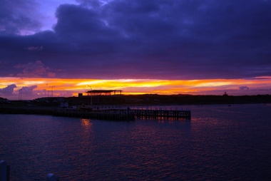
Digital photographs, L.J. Gervasoni, Harbour Pavilion under construction, c2010
... Office goldfields warrnambool coast coastal beach seascape ...warrnambool, coast, coastal, beach, seascape, harbour pavilion, construction, sunset, viaduct road, breakwater -
 Ringwood RSL Sub-Branch
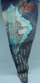
Souvenir Navy Pennant, HMAS Hobart
Blue Felt Pennant with a picture of the ship HMAS Hobart.Battle Honours or Ports of call - Bay City Norfolk Panama Canal Long Beach San Diego Port Hueneme Vancouver San Francisco Pearl Harbour Sydney Boston Mayport Fiji -
 Flagstaff Hill Maritime Museum and Village
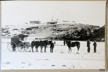
Photograph - Scene - Warrnambool, C. 1854-1871
This is an image of the Warrnambool Lighthouse Complex on Middle Island in 1854. The Store, Lighthouse Keeper's Quarters, Lighthouse and Flagstaff are in the background. The foreground shows a covered buggy drawn by two horses and a person in attendance, and another wheeled vehicle behind it with a figure nearby. There is a saddled horse to the right with two males in conversation nearby. The ground is soft, perhaps the riverbed or sandy shore. THE LIGHTHOUSE KEEPERS Lighthouse Keepers were responsible for keeping their Lighthouse’s lights shining at night. They kept a lookout for passing vessels and changes in weather. They were expected to clean, polish and maintain the equipment and buildings. They kept regular and detailed records of who was on watch, and the time the light was lit, trimmed and extinguished. They kept a journal about other events that occurred. They keep regular, accurate Meteorological Logs. It was expected that they were competent in Morse code signalling. They would be called to help in times of disasters and shipwrecks and to give official statements about these events. Many Lighthouse Keepers also volunteered as members of the lifeboat crew. The Lady Bay lighthouses were officially classified as small, so the Keepers had the official titles of Senior Assistant Lighthouse Keeper and Assistant Lighthouse Keeper. They were employed by the Public Service and paid rent to live in the Lighthouse Quarters. They were compulsorily retired at the age of 60, with most receiving a superannuation payment. Despite their time-consuming duties, there was time to follow hobbies and crafts such as growing vegetables, playing musical instruments, making models of buildings including lighthouses, and crafting furniture pieces. An example of a keeper’s skills is the carved fire screen made by /assistant Keeper Thomas Hope in the late 19th century and displayed in the Lighthouse Keeper’s cottage at Flagstaff Hill. Both Alexander and Farncombe had served under Senior Keeper Robert Deverell, who was the first and only Senior Lighthouse Keeper at the Middle Island Complex. John Alexander was the Assistant Keeper in the 1850s. Andrew Farncombe was the last Assistant Keeper at Middle Island, serving there with his family from 1864 to 1871. During 1871 and 1872 the Lighthouse Complex was moved to Flagstaff Hill on Merri Street. Farncombe and Deverell then became the first Keepers and occupants of the Lady Bay Lighthouse Complex at Flagstaff Hill. They continued their service together; overall, Deverell served from 1859 to 1885 and Farncombe from 1864 to 1974. WARRNAMBOOL'S LADY BAY LIGHTHOUSE COMPLEX - The original Lighthouse Complex was built on Middle Island in 1858-1859 then transferred stone-by-stone to Flagstaff Hill in 1871. The Complex comprised the Lighthouse, the Lighthouse Keepers’ Quarters and a Privy. The bluestone Keeper’s Quarters was a cottage divided into two compartments, one for the Senior Keeper and his family, the other for the Assistant Keeper and his family. The bluestone Store was divided into three; a store, a workshop, and an oil store (or office). The Privy comprised a small building also divided into two separate, back-to-back toilets, one for each Keeper and his family. In the 1970s the Flagstaff Hill Planning Board was set up under the chairmanship of John Lindsay. The Board was to make recommendations to the Warrnambool City Council regarding the use of the buildings and the rest of the Crown Land on the site. The Flagstaff Hill Maritime Village opened in 1975 and began renovating the Cottage in stages, during which time evidence of a 1920s fire was found in the eastern section of the cottage. Additions of a porch on the west and a washroom on the east were made in the 1980s. The western part of the building is now a Shipwreck Museum and the east has returned to a late 19th-century Lighthouse Keeper’s cottage and includes the screen made by Assistant Lighthouse Keeper Thomas Hope in the late 19th century. Hope served two periods of time at the Lighthouse. This photograph is significant as a visual record of the original Warrnambool Lighthouse Complex on Middle Island, the origin of what is now the Lady Bay Lighthouse Complex. The photograph is significant for its connection to the Complex, which is now listed on the Victorian Heritage Register, H1520, for being of historical, scientific (technological) and architectural significance to the State of Victoria. The Complex is significant as an example of early colonial development. The photograph is significant for its connection with the important navigational function of the Lighthouses, a function still being performed to this day. The photograph is also significant as it shows an example of buildings organised by the Public Works Department in Victoria in the mid-to-late 19th century. The structures tare still stand strong. Photograph of horses, a buggy and three gentlemen in the foreground and the background shows a lighthouse and accompanying buildings. Printed in black and white. (Another two horse-drawn vehicles are partially visible). The subject is the Lighthouse Complex on Middle Island, Warrnambool, dated between 1854 and 1871.An inscription is handwritten in black pen on the back of the mounting board."The lighthouse and accompanying buildings were / established on Middle Island in 1854, as this / picture shows. In 1871 they were moved to their / present site on Flagstaff Hill."flagstaff hill, flagstaff hill maritime museum, flagstaff hill maritime village, warrnambool, maritime museum, shipwreck coast, lighthouse keeper's cottage, lighthouse residence, lighthouse, chart room, quarters, privy, middle island, beach lighthouse, obelisk, lighthouse complex, lady bay complex, warrnambool port, warrnambool harbour, lady bay, keepers, lighthouse keeper, upper lighthouse, lower lighthouse, assistant keeper, ports and harbours, cottage, meteorological record, 1854, 1871 -
 Glenelg Shire Council Cultural Collection
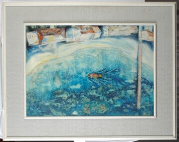
Painting, Summer Holiday, 1967
Aerial view of a harbour with a jetty and a boat. At edge of water is a narrow beach and 4 houses (white with roofs painted in orange, yellow, white and pale blue). Seaweed and reefs are visible below surface of water. Framed in wood and board frame (white and grey).Front: Barnard 1967 (lower left, blue paint). Back: Phyl Barnard "Summer Holiday" 1967. -
 Melbourne Tram Museum
Ephemera - Timetable/s, Public Transport Victoria (PTV), Set of 25 digital timetables, 2018
Set of 25 digital timetables generally applicable from 20-05-2018 following the introduction of more frequent services on many routes. Image files are htd2860iRx - x being the route number. Route 1 - East Coburg - South Melbourne Beach Route 3 and 3A - Melbourne University - East Malvern - and via St Kilda Beach Route 5 - Melbourne University - Malvern Route 6 - Melbourne University - Glen Iris Route 8 - Moreland - Toorak Route 11 - West Preston - Victoria Harbour Docklands Route 12 - Victoria Gardens - St Kilda Route 16 - Melbourne University - Kew Via St Kilda Route 19 - North Coburg - Flinders St Route 30 - St Vincent's Plaza - Etihad Stadium Docklands Route 35 - City Circle Route 48 - North Balwyn - Victoria Harbour Docklands Route 55 - West Coburg - Domain Interchange Route 57 - West Maribyrnong - Flinders St Route 59 - Airport West - Flinders St Route 64 - East Brighton - Melbourne University Route 67 - Carnegie - Melbourne University Route 70 - Wattle Park - Waterfront City Docklands Route 72 - Camberwell - Melbourne University Route 75 - Vermont South - Etihad Stadium Docklands Route 78 - North Richmond - Balaclava via Prahran Route 82 - Footscray - Moonee Ponds Route 86 - Bundoora RMIT - Waterfront City Docklands Route 96 - East Brunswick - St Kilda Beach Route 109 - Box Hill - Port Melbournetrams, tramways, timetables, yarra trams, route 1, route 3, route 5, route 6, route 8, route 11, route 12, route 16, route 19, route 30, route 35, route 48, route 55, route 57, route 59, route 64, route 67, route 70, route 72, route 75, route 78, route 82, route 86, route 96, route 109 -
 Melbourne Tram Museum
Ephemera - Tram Route Guides, Public Transport Victoria (PTV), "Tram Route Map", 1/2015 and 6/2015
Set of 7 Tram Route Maps, published during 2015. Each comprises a vertical DL folded sheet, full colour for the nominated routes, with Yarra Trams and PTV logos, listing the stops, interchanges with bus and other tram services, ticketing zones, estimated frequencies with adverts for Night tram services, TramTracker and Myki tickets. .1 - Route 5 - Melbourne University to Malvern .2 - Route 6 - Melbourne University to Glen Iris .3 - Route 8 - Moreland to Toorak .4 - Route 11 - West Preston - Victoria Harbour Docklands .5 - Route 19 - North Coburg - Flinders St Station .6 - Route 70 - Wattle Park to Waterfront City Docklands .7 - Route 72 - Melbourne University to Camberwell .8 - Route 1 - East Coburg - South Melbourne Beach .9 - Route 3 and 3A - Melbourne University to East Malvern .10 - Route 16 - Melbourne University to Kew .11 - Route 55 - West Coburg - Domain Interchange .12 - Route 57 - West Maribyrnong - Flinders St Station .13 - Route 59 - Airport West - Flinders St. Station .14 - Route 64 - Melbourne University - East Brighton .15 - Route 67 - Melbourne University - Carnegie .16 - Route 78 - North Richmond - Balaclava via Prahran .17 - Route 82 - Footscray - Moonee Ponds See Reg Item 2396 for 2012, 2278 for 2016 and 2940 for 2014 versionstrams, tramways, timetables, maps, route 1, route 3, route 5, route 6, route 8, route 11, route 16, route 19, route 55, route 57, route 59, route 64, route 67, route 70, route 72, route 78, route 82, east coburg, south melbourne, east malvern, kew, west coburg, west maribyrnong, airport west, east brighton, carnegie, north richmond, balaclava, footscray, moonee ponds, malvern, glen iris, moreland, west preston, north coburg, wattle park, camberwell -
 Melbourne Tram Museum
Ephemera - Tram Route Guides, Public Transport Victoria (PTV), "Tram Route Guide and Map", Oct. 13 to July 14
Set of 17 Tram Route Maps, published during 2013 and 2014. Each comprises a vertical DL folded sheet, full colour for the nominated routes, with Yarra Trams and PTV logos, listing the stops, interchanges with bus and other tram services, ticketing zones, estimated frequencies with adverts for Night tram services, TramTracker and Myki tickets. .1 - Route 3 - East Malvern - Melbourne Uni and 3A via St Kilda (Sat and Sun) .2 - Route 6 - Melbourne University to Glen Iris .3 - Route 12 - St Kilda - Victoria Gardens .4 - Route 16 - Kew via St Kilda .5 -Route 30 - St Vincent's Plaza - Etihad Stadium .6 - Route 55 - West Coburg - Domain Interchange .7 - Route 59 - Airport West - City (Elizabeth St) .8 - Route 64 - Melbourne University - East Brighton .9 - Route 70 - Wattle Park to Waterfront City Docklands .10 - Route 75 - Docklands - Vermont South .11 - Route 78 - North Richmond - Balaclava .12 - Route 82 - Moonee Ponds - Footscray .13 - Route 86 - Bundoora - Waterfront City .14 - Route 96 - East Brunswick - St Kilda Beach .15 - Route 109 - Box Hill - Port Melbourne .16 - Route 112 and 11 - West Preston - St Kilda and West Preston - Victoria Harbour Docklands .17 - Route 24 - North Balwyn to Etihad Stadium See Reg Item 2396 for 2012, 2278 for 2016 and 2939 for 2015 versionstrams, tramways, timetables, maps, route 3, route 6, route 11, route 12, route 16, route 24, route 30, route 55, route 59, route 64, route 70, route 75, route 78, route 82, route 86, route 96, route 109, route 112, east malvern, glen iris, victoria gardens, kew, st vincent's plaza, west coburg, airport west, east brighton, wattle park, vermont south, north richmond, moonee ponds, footscray, st kilda, docklands, west preston, victoria harbour, north balwyn, etihad stadium -
 Melbourne Tram Museum
Ephemera - Tram Route Guides, Public Transport Victoria (PTV), "Tram Route Guide", Feb. 2016
Set of 18 Tram Route Guides, published during 2016. Each comprises a vertical DL folded sheet, full colour for the nominated routes, with Yarra Trams and PTV logos, listing the stops, interchanges with bus and other tram services, ticketing zones, estimated frequencies with adverts for Night tram services, TramTracker and Myki tickets. .1 - Route 1 - East Coburg to South Melbourne Beach .2 - Route 5 - Melbourne University to Malvern .3 - Route 6 - Melbourne University to Glen Iris .4 - Route 8 - Moreland to Toorak .5 -Route 57 - West Maribyrnong to Flinders St Station (2 copies) .6 - Route 70 - Wattle Park to Waterfront City Docklands .7 - Route 72 - Melbourne University to Camberwell .8 - Route 75 - Vermont South to Etihad Stadium / Bourke St Docklands .9 - Route 82 - Footscray to Moonee Ponds .10 - Route 19 - North Coburg to Flinders St Station .11 - Route 55 - West Coburg to Domain Interchange (two copies held) .12 - Route 59 - Airport West to Flinders St Station .13 - Route 30 - St Vincent's Plaza to Ethida Stadium Docklands .14 - Route 12 - Victoria Gardens to St Kilda / Fitzroy St .15 - Route 64 - Melbourne University to East Brighton .16 - Route 78 - North Richmond to Balaclava (via Prahran) .17 - Route 86 - Bundoora (RMIT) to Waterfront City Docklands .18 - Route 96 - East Brunswick to St Kilda Beach .19 - Route 11 - West Preston to Victoria Harbour Docklands ,20 - Route 16 - Melbourne University to Kew via St Kilda .21 - Route 48 - North Balwyn to Victoria Harbour Docklands .22 - Route 67 - Melbourne University to Carnegie .23 - Route 109 - Box Hill to Port Melbourne See Reg Item 2396 for 2012, 2939 for 2015 and 2940 for 2014 versions Items .13 to .18 added 2/9/18Item 11 has the "5" changed to "8" in Texta - see history of object.trams, tramways, timetables, maps, route 1, route 5, route 6, route 8, route 11, route 16, route 132, route 19, route 30, route 48, route 55, route 57, route 59, route 64, route 67, route 70, route 72, route 75, route 78, route 82, route 86, route 96, route 109, east coburg, west coburg, airport west, north coburg, south melbourne, malvern, glen iris, moreland, toorak, west maribyrnong, wattle park, docklands, camberwell, vermont south, footscray, moonee ponds, st vincent's plaza, victoria gardens, east brighton, north richmond, balaclava, bundoora, east brunswick, west preston, kew, north balwyn, carnegie, box hill -
 Melbourne Tram Museum
Ephemera - Tram Route Guides, Public Transport Victoria (PTV), "Tram Route Guide", Oct. 2011 to Oct 2012
Set of 23 Tram Route Guides, published during 2011 or 2012. Each comprises a vertical DL folded sheet, full colour for the nominated routes, with Yarra Trams, Myki and TramTracker logos, listing the stops, interchanges with bus and other tram services, ticketing zones, estimated frequencies with adverts for Night tram services, TramTracker and Myki tickets. .1 - Route 5 - Melbourne University to Malvern .2 - Route 16 - Melbourne University to Kew .3 - Route 24 and 30 - North Balwyn - Latrobe St and St Vincent's Plaza - Etihad Stadium .4 - Route 48 - North Balwyn - Victoria Harbour Docklands .5 - Route 55 - West Coburg - Domain Interchange .6 - Route 57 - West Maribyrnong to Flinders St Station .7 - Route 59 - Airport West - City .8 - Route 75 - City - Vermont South .9 - Route 78 and 79 - North Richmond - Prahran or St Kilda Beach .10 - Route 82 - Footscray to Moonee Ponds .11 - Route 96 - East Brunswick - St Kilda Beach .12 - ditto .13 - Route 112/11 - West Preston - St Kilda, West Preston - Victoria Harbour Docklands .14 - Route 70 - Wattle Park - Waterfront City Docklands .15 - Route 86/95 - Bundoora - Waterfront City Docklands and Melbourne Museum - City .16 - Route 1 - East Coburg - South Melbourne Beach .17 - Route 3/3a - Melbourne University to East Malvern .18 - Route 6 - Melbourne University to - Glen Iris .19 - Route 8 - Moreland to Toorak .20 - Route 64 - Melbourne University to East Brighton .21 - Route 67 - Melbourne University to Carnegie .22 - Route 72 - Melbourne University to Camberwell .23 - Route 109 - Box Hill - Port Melbourne and Route 31 - Hoddle St - Victoria Harbour - Docklands .24 - Route 75 - Vermont South - dated 10/2011 See Reg Item 2278 for 2016 versionstrams, tramways, timetables, maps, route 1, route 3/3a, route 5, route 6, route 8, route 11, route 16, route 24, route 30, route 31, route 48, route 55, route 57, route 59, route 64, route 67, route 70, route 72, route 75, route 78, route 79, route 82, route 86, route 95, route 96, route 109, route 112, east coburg, south melbourne, malvern, west maribyrnong, airport west, docklands, north balwyn, west coburg, domain interchange, north richmond, prahran, east brunswick, st kilda, vermont south, footscray, moonee ponds, kew, st vincent's plaza, preston, wattle park, bundoora, museum, south melbourne beach, east coburg, east malvern, glen iris, toorak, moreland, east brighton, carnegie, camberwell, box hill, port melbourne -
 Melbourne Tram Museum
Ephemera - Timetable/s, Public Transport Victoria (PTV), Set of 25 digital timetables - Yarra Trams, 2016
Set of 25 digital timetables generally applicable 2016 to 13/4/2017. Similar timetables ran during 13/4/2017 and 1/5/2017 over the Easter Holiday period up to when Route 58 (from route 8 and route 55) introduced and route 6 modified - see Reg item 2212 for details. List major stops only. All downloaded from the PTV website 9-4-17 as pdf files. Image files are htd2211iRx - x being the route number. Route 1 - East Coburg - South Melbourne Beach Route 3 and 3A - Melbourne University - East Malvern - and via St Kilda Beach Route 5 - Melbourne University - Malvern Route 6 - Melbourne University - Glen Iris Route 8 - Moreland - Toorak Route 11 - West Preston - Victoria Harbour Docklands Route 12 - Victoria Gardens - St Kilda Route 16 - Melbourne University - Kew Via St Kilda Route 19 - North Coburg - Flinders St Route 30 - St Vincent's Plaza - Etihad Stadium Docklands Route 35 - City Circle Route 48 - North Balwyn - Victoria Harbour Docklands Route 55 - West Coburg - Domain Interchange Route 57 - West Maribyrnong - Flinders St Route 59 - Airport West - Flinders St Route 64 - East Brighton - Melbourne University Route 67 - Carnegie - Melbourne University Route 70 - Wattle Park - Waterfront City Docklands Route 72 - Camberwell - Melbourne University Route 75 - Vermont South - Etihad Stadium Docklands Route 78 - North Richmond - Balaclava via Prahran Route 82 - Footscray - Moonee Ponds Route 86 - Bundoora RMIT - Waterfront City Docklands Route 96 - East Brunswick - St Kilda Beach Route 109 - Box Hill - Port Melbournetrams, tramways, timetables, yarra trams, route 1, route 3, route 5, route 6, route 8, route 11, route 12, route 16, route 19, route 30, route 35, route 48, route 55, route 57, route 59, route 64, route 67, route 70, route 72, route 75, route 78, route 82, route 86, route 96, route 109 -
 Melbourne Tram Museum
Ephemera - Timetable/s, Public Transport Victoria (PTV), Set of 24 digital timetables - Yarra trams, 2016
Set of 24 digital timetables generally applicable 1/4/2017 to end 2017 Introduced when Route 58 (from route 8 and route 55) amalgamated and route 6 modified - see Reg item 2212 for details. All downloaded from the PTV website 9-4-17 as pdf files, except for routes 6 and 58 which had not been published as of that date. Timetables list major stops. Routes 6 and 58 files added 6-6-2017. Image files are htd2213iRx - x being the route number. Route 1 - East Coburg - South Melbourne Beach Route 3 and 3A - Melbourne University - East Malvern - and via St Kilda Beach Route 5 - Melbourne University - Malvern Route 6 - Moreland - Glen Iris Route 11 - West Preston - Victoria Harbour Docklands Route 12 - Victoria Gardens - St Kilda Route 16 - Melbourne University - Kew Via St Kilda Route 19 - North Coburg - Flinders St Route 30 - St Vincent's Plaza - Etihad Stadium Docklands Route 35 - City Circle Route 48 - North Balwyn - Victoria Harbour Docklands Route 57 - West Maribyrnong - Flinders St Route 58 - Toorak - West Coburg via William St. Route 59 - Airport West - Flinders St Route 64 - East Brighton - Melbourne University Route 67 - Carnegie - Melbourne University Route 70 - Wattle Park - Waterfront City Docklands Route 72 - Camberwell - Melbourne University Route 75 - Vermont South - Etihad Stadium Docklands Route 78 - North Richmond - Balaclava via Prahran Route 82 - Footscray - Moonee Ponds Route 86 - Bundoora RMIT - Waterfront City Docklands Route 96 - East Brunswick - St Kilda Beach Route 109 - Box Hill - Port Melbournetrams, tramways, timetables, yarra trams, route 1, route 3, route 5, route 6, route 11, route 12, route 16, route 19, route 30, route 35, route 48, route 57, route 58, route 59, route 64, route 67, route 70, route 72, route 75, route 78, route 82, route 86, route 96, route 109 -
 Melbourne Tram Museum
Ephemera - Timetable/s, Public Transport Victoria (PTV), 2019
Set of 24 digital timetables generally applicable from 1-1-2019. Image files are htd3520iRx - x being the route number. Route 1 - East Coburg - South Melbourne Beach Route 3 and 3A - Melbourne University - East Malvern - and via St Kilda Beach - two timetables for each Route 5 - Melbourne University - Malvern Route 6 - Melbourne University - Glen Iris Route 11 - West Preston - Victoria Harbour Docklands Route 12 - Victoria Gardens - St Kilda Route 16 - Melbourne University - Kew Via St Kilda Route 19 - North Coburg - Flinders St Route 30 - St Vincent's Plaza - Etihad Stadium Docklands - though the stadium was renamed Marvel after Marvel comics by Disney during May 2018. Old name retained, but appears to becoming just Docklands Stadium on Yarra trams website when this item added. Route 35 - City Circle - NOT Published. Route 48 - North Balwyn - Victoria Harbour Docklands Route 55 - West Coburg - Domain Interchange Route 57 - West Maribyrnong - Flinders St Route 58 - Toorak to Route 59 - Airport West - Flinders St Route 64 - East Brighton - Melbourne University Route 67 - Carnegie - Melbourne University Route 70 - Wattle Park - Waterfront City Docklands Route 72 - Camberwell - Melbourne University Route 75 - Vermont South - Etihad Stadium Docklands Route 78 - North Richmond - Balaclava via Prahran Route 82 - Footscray - Moonee Ponds Route 86 - Bundoora RMIT - Waterfront City Docklands Route 96 - East Brunswick - St Kilda Beach Route 109 - Box Hill - Port Melbournetrams, tramways, timetables, yarra trams, route 1, route 3, route 5, route 6, route 8, route 11, route 12, route 16, route 19, route 30, route 48, route 55, route 57, route 58, route 59, route 64, route 67, route 70, route 72, route 75, route 78, route 82, route 86, route 96, route 109 -
 Melbourne Tram Museum
Ephemera - Timetable/s, Public Transport Victoria (PTV), Timetable Notice giving details of temporary changes to service as part of the COVID 19, 2020
Timetable Notice giving details of temporary changes to service as part of the COVID 19 response where route 12 diverted by La Trobe St, and thus provided a service along Spencer St. Route 30 was suspended. Route 11A was introduced between Docklands and St Vincent's Plaza. htd4777i1.pdf shows a timetable alteration, reduction of services after 8pm, introduction of the 8pm to 5am curfew and stage four restrictions that were to apply (hopefully) for a six week period. Set of 23 digital timetables generally applicable from 10-11-2019 and two timetables for route 11 and12 applicable from 13 July. This change was a bit confusing at the time. Image files are htd4777iRx - x being the route number. Route 1 - East Coburg - South Melbourne Beach Route 3 and 3A - Melbourne University - East Malvern - and via St Kilda Beach - two timetables for each Route 5 - Melbourne University - Malvern Route 6 - Melbourne University - Glen Iris Route 11 - West Preston - Victoria Harbour Docklands Route 12 - Victoria Gardens - St Kilda Route 16 - Melbourne University - Kew Via St Kilda Route 19 - North Coburg - Flinders St Route 30 - St Vincent's Plaza - Etihad Stadium Docklands - though the stadium was renamed Marvel after Marvel comics by Disney during May 2018. Route 35 - City Circle - NOT Published. Route 48 - North Balwyn - Victoria Harbour Docklands Route 55 - West Coburg - Domain Interchange Route 57 - West Maribyrnong - Flinders St Route 58 - Toorak to Route 59 - Airport West - Flinders St Route 64 - East Brighton - Melbourne University Route 67 - Carnegie - Melbourne University Route 70 - Wattle Park - Waterfront City Docklands Route 72 - Camberwell - Melbourne University Route 75 - Vermont South - Etihad Stadium Docklands Route 78 - North Richmond - Balaclava via Prahran Route 82 - Footscray - Moonee Ponds Route 86 - Bundoora RMIT - Waterfront City Docklands Route 96 - East Brunswick - St Kilda Beach Route 109 - Box Hill - Port Melbournetrams, tramways, timetables, yarra trams, route 1, route 3, route 5, route 6, route 8, route 11, route 11a, route 12, route 16, route 19, route 30, route 48, route 55, route 57, route 58, route 59, route 64, route 67, route 70, route 72, route 75, route 78, route 82, route 86, route 96, route 109, covid-19, st vincent's plaza, spencer st -
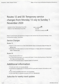
 Glenelg Shire Council Cultural Collection
Painting, Thomas Clark, Portland Bay, c. 1860
Port of Portland AuthorityView of Portland Bay with a bluff in foreground left. On top of bluff is a lighthouse and a white cottage. Lighthouse is white with a red roof. Cottage has a tall flagpole flying a red flag. Two figures stand in front of cottage. Below bluff are two further figures looking out to see. In background right is a town and harbour. Further figures can be seen on the beach. Framed in ornate gilded frame.Front: (no inscriptions) Plaque on frame read: "PRESENTED BY MRS. J.E. GRICE GRAND DAUGHTER OF STEPHEN GEORGE AND JANE HENTY." Back: (unknown)portland bay, thomas clark -
 Flagstaff Hill Maritime Museum and Village
Photograph - Historical, building, Late 19th to early 20th century
The black and white photograph depicts the Lady Bay Lighthouse Complex at Flagstaff Hill, Warrnambool. It was opened on this site in 1871. From left to right, the Chartroom (previously named the Store), Upper Lighthouse, Flagstaff, Lighthouse Keeper's Quarters. The bluestone buildings are facing North on Merri Street. The Harbour Pilot's Lodgings were on the east of the Complex. There are two unknown male figures standing in front of the light-coloured picket fence that encompasses the Complex. The photograph is mounted on card. WARRNAMBOOL'S LADY BAY LIGHTHOUSES In the 1800s ships sailing from England to Australia began to use Bass Strait as a faster route to Melbourne. Small navigation errors led to many tragic shipwrecks. From 1848 lighthouses were operating along Victoria’s southern coast as a guide for sailors. Coastal towns such as Warrnambool grew and the exchange of trade and passengers was of great benefit. However, the uncertain weather changes, relatively shallow waters and treacherous, hidden rocky reefs were not really suitable for a Harbour and in the 1840s and 1850s, there were many shipwrecks in the area, with some even stranded in its Lady Bay harbour. A jetty was built in 1850 and a flagstaff to guide seafarers was placed up high on what became known now as Flagstaff Hill. In November 1857 the Victorian Government recommended that Warrnambool Harbour had beacons and two lighthouses to guide vessels into and out of the Harbour safely. The white light of the Middle Island lighthouse was to be used for the first time on September 1, 1859. The red light of the Beach Lighthouse, a wooden obelisk structure, was first operated on March 25, 1860, but in 1868 this light was ‘discontinued’ due to it being too low. Melbourne’s Department of Public Works decided to relocate the Middle Island Lighthouse Complex - Lighthouse, Keeper’s Quarters, Privy, Store Room and even water tanks - to Flagstaff Hill. The lower obelisk was shortened, and a protruding gallery, railing, and external ladder were added, and the light from the Beach Lighthouse. A green guiding light was erected on the end of the jetty. The transfer of the Complex began in March 1871. Each shaped stone of the lighthouse was carefully numbered, removed then reassembled on Flagstaff Hill. In 1872 the well was sunk behind the Lighthouse Keeper’s Cottage. The Keepers and families had left Middle Island in April and moved to Flagstaff Hill in October 1871. Vessels entering Lady Bay align the Upper and Lower Lighthouse towers during the day and the lights at night. The Upper Lighthouse is a round tower, and the Lower Light is square. The Lighthouses were categorised as harbour lights rather than coastal lights, so they remain under the control of the Victorian Government’s Ports and Harbours section. The lights were originally powered by oil, then acetylene gas, later by electricity, and then converted to solar power in 1988. In 1993 the solar panel was replaced by a battery charger. A decision was made in 1936 to replace the lighthouses’ lights with unattended lights that no longer required Keepers and Assistants. At least 29 Keepers had attended to the lighthouse from its opening in 1859 to when the last official Lightkeepers left In April 1916. The Warrnambool Harbour Board rented out the Quarters from 1916 to 1936. The Board closed down but the rentals continued with other unknown landlords. In the 1970s the Flagstaff Hill Planning Board was set up under the chairmanship of John Lindsay. The Board was to make recommendations to the Warrnambool City Council regarding using the buildings and the rest of the Crown Land on the site. The Flagstaff Hill Maritime Village opened in 1975 and began renovating the Cottage in stages, during which time evidence of a 1920s fire was found in the eastern section of the cottage. Additions of a porch on the west and a washroom on the east were made in the 1980s. The western part of the building is now a Shipwreck Museum and the east has returned to a late 19th-century Lighthouse Keeper’s cottage and includes the screen made by Assistant Lighthouse Keeper Thomas Hope in the late 19th century. He served as Assistant Keeper in Warrnambool for two periods.The Warrnambool Lighthouse Complex is now listed on the Victorian Heritage Register, H1520, for being of historical, scientific (technological) and architectural significance to the State of Victoria. The Complex is significant as an example of early colonial development. The buildings are significant for their connection with the important navigational function of the Lighthouses, a function still being performed to this day. The buildings are also significant as an example of structures designed and works carried out by the Public Works Department in Victoria in the mid-to-late 19th century. The structures still stand strong. Photograph; Warrnambool Lighthouse Keeper's cottage, lighthouse, flagstaff and chartroom at Flagstaff Hill, and a light-coloured picket fence with gate. Two male figures are in front of the fence. Black and white print glued to a yellow card. The inscription is indecipherable. The right side of the cottage has a built-in, enclosed addition.Ink stamped in lower right hand corner, too faded to be legible.flagstaff hill, flagstaff hill maritime museum, flagstaff hill maritime village, warrnambool, maritime museum, shipwreck coast, lighthouse keeper's cottage, lighthouse residence, lighthouse, chart room, quarters, privy, middle island, beach lighthouse, obelisk, lighthouse complex, lady bay complex, warrnambool port, warrnambool harbour, lady bay, keepers, lighthouse keeper, upper lighthouse, lower lighthouse, assistant keeper, ports and harbours, cottage -
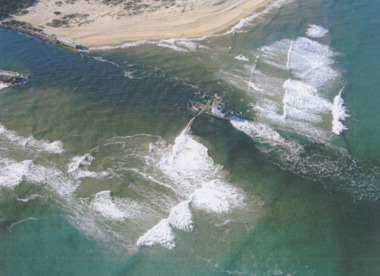 Lakes Entrance Historical Society
Photograph - Boat Harbour, Gippsland Ports, dredge April Hamer Lakes Entrance, 2006
Colour aerial photograph of the Entrance from Bass Strait to the Gippsland Lakes showing rock entrance groynes, surf on beach, dredge April Hamer working in the channel Lakes Entrance Victoria. Also another copy size 15 x 19.5 cmwaterways, topography, beaches, ocean