Showing 1060 items
matching healesville-sanctuary
-
 Melbourne Water
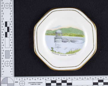
Dish, Maroondah Reservoir, Healesville Souvenir, 1930s-1940s
The Maroondah System was first and foremost developed as a functional component of Melbourne's Water Supply System. In addition to functionality, the Melbourne and Metropolitan Board of Works (MMBW) envisioned the Maroondah Reserve to be enjoyed aesthetically and recreationally by the public. This souvenir illustrates the realisation of the Maroondah System as a local recreational and tourist attraction in the early 20th century. The Maroondah Reserve gardens were landscaped with English-style ornamental stonework, exotic trees, flower beds and rose gardens. All features of the water supply system became widely celebrated as beauty spots that continue to be very popular to this day with tourists and locals alike. This souvenir is a product of that flourishing tourist trade. These water supply sites continue to enhance Melbourne’s charm and liveability and are now recognised as places of cultural and historic significance.Manufactured in England, this souvenir dish made from bone china with gold trim, features an illustration of the Maroondah Reservoir in the centre reading, “Maroondah Reservoir, Healesville”. On the back of the dish is the makers mark, Royal Stafford, one of the oldest pottery factories in Staffordshire, England. The Royal Stafford brand was established in 1845 and continues to provide high quality tableware in the present day. This souvenir item has been curated by Melbourne Water as it represents an important historical aspect of the organisation by demonstrating the popularity of its water asset sites as recreational places and tourist attractions, and although these sites are functional parts of the water supply system, they were also designed to be enjoyed by the public both aesthetically and recreationally. Souvenir dish made from bone china with gold trim, featuring an illustration of the Maroondah Reservoir in the centre reading, “Maroondah Reservoir, Healesville”.Makers mark, Royal Stafford.maroondah, healesville, dish, porcelain, melbourne metropolitan board of works, melbourne water, mmbw -
 Marysville & District Historical Society
Photograph (item) - Black and white photograph, Unknown
An early black and white photograph of the residents of Coranderrk Aboriginal Station near Healesville in Victoria.An early black and white photograph of the residents of Coranderrk Aboriginal Station near Healesville in Victoria.coranderrk, john green, kulin nation, healesville -
 Whitehorse Historical Society Inc.
Article, Whitehorse vision for Healesville, 2014
City of Whitehorse Vision for Healesville Freeway Reservation.City of Whitehorse Vision for Healesville Freeway Reservation to include open space, sustained natural environment and some residential development covering 19% of the land.City of Whitehorse Vision for Healesville Freeway Reservation.healesville freeway reservation, city of whitehorse -
 Greensborough Historical Society
Photograph - Digital image, Unidentified location, possibly Healesville, 1880c
Hut, unidentified location, possibly Healesville. Photograph found by Peter Blackbourn in a miner's cottage, in Healesville, in 1974. Photographs from the collection of Peter Blackbourn, a descendant of the Chapman Stock family. Annotations to photos by Peter Blackbourn.Digital copy of black and white photograph.peter blackbourn -
Healesville Sanctuary Heritage Centre
Newspaper - Cutting, Dennehy, A B, Sanctuary, 17 June 1949
Letter stating interest of local people in the Sanctuary.photocopynon-fictionLetter stating interest of local people in the Sanctuary. 1940s -
 Marysville & District Historical Society
Ephemera (Item) - Book page, Unknown
A page from a unknown book regarding Marysville and the surrounding district including Narbethong, Healesville and Warburton.A page from a unknown book regarding Marysville and the surrounding district including Narbethong, Healesville and Warburton.marysville, victoria, narbethong, healesville, warburton, toolangi, launching place, box hill, ringwood, lilydale, watts river, yea river, sylvia falls, don road, wood's point, baw baws, maroondah reservoir, graceburn weir, mt juliet, fernshaw -
 Whitehorse Historical Society Inc.
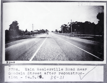
Photograph, Main Healesville Road 1938, 24/05/1938 12:00:00 AM
Black and white photograph of main Healesville Road (Whitehorse Road) near Goodwin Street, Blackburn after road construction on 24 May 1938. Other Number 3724healesville road, blackburn, goodwin street, blackburn., whitehorse road -
 Marysville & District Historical Society
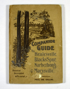
Book, The Atlas Press, Companion Guide to Healesville, Blacks' Spur, Narbethong & Marysville, 1904
A companion guide to Healesville, Blacks' Spur, Narbethong & Marysville. With photographs, information and a pull-out map.Paperback. Front cover has a drawing of a countryside outlook. The book contains 65 photographs and information relating to the locations listed on the front cover. There is a pull-out map located on the inside of the back cover.non-fictionA companion guide to Healesville, Blacks' Spur, Narbethong & Marysville. With photographs, information and a pull-out map.healesville, black spur, narbethong, marysville, victoria, history -
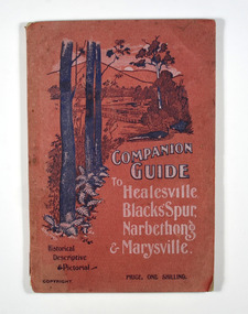 Marysville & District Historical Society
Book, The Atlas Press, Companion Guide to Healesville, Blacks' Spur, Narbethong & Marysville, 1904
A companion guide to Healesville, Blacks' Spur, Narbethong & Marysville. With photographs, information and a pull-out map.Paperback. Front cover has a drawing of a countryside outlook. The book contains 65 photographs and information relating to the locations listed on the front cover. There is a pull-out map located on the inside of the back cover. Back cover has details of the rail and coach services available to travel to the destinations mentioned in the book. non-fictionA companion guide to Healesville, Blacks' Spur, Narbethong & Marysville. With photographs, information and a pull-out map.healesville, black spur, narbethong, marysville, victoria, history -
Healesville Sanctuary Heritage Centre
Newspaper - Cutting, Gasking, W R, Sanctuary News, 21 November 1956
Distinguished visitors to visit the Sanctuary.Photocopy1950s -
Vision Australia
Text, RVIB Healesville Auxiliary, 1929 - 1996
The Healesville RVIB Auxiliary formed on September 24, 1929. This small collection contains correspondence to and from RVIB head office between ranging between 1990 -1996. Various loose papers and letters royal victorian institute for the blind -
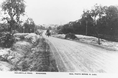 Ringwood and District Historical Society
Photograph, Maroondah Highway East, Ringwood- c.1920. "Healesville Road, Ringwood" postcard featuring westward view along Whitehorse Road towards Mount Dandenong Road
4 photographs (2 large black and white, 2 small sepia postcard)Postcard labelled Healesville Road, Ringwood. Typed under large copy: "Looking down a dry Maroondah Highway from outside (eventual) Civic Centre site towards Mt. Dandenong Rd corner." -
 Yarra Glen & District Historical Society
Sepia postcards, Yarra Glen from the Healesville railway line
Sepia postcard with a view of Yarra Glen taken from the east on the railway line adjacent to the Healesville Rd. The view extends from the railway station to Point Pleasant and includes Victoria Hall, the Grand Hotel and Mrs Roberts' house.On back of postcard at the top "POST CARD". On the left hand side "THIS SPACE MAY BE USED FOR PRINTED OR WRITTEN MATTER". On the right hand side "ONLY THE ADDRESS TO BE WRITTEN HERE". In a box in the right hand corner "A HALF-PENNY STAMP TO BE PLACED HERE". Along the left hand margin "Ajax series. Printed in England". COPY 2: Also has handwritten on back "March 5th 1929 Mount Wise, Yarra Glen. Our dear Lorna Lesley, Melbourne. Just a [few]lines to wish you a happy birthday, fancy tomorrow you will be nine years old. It only seems like nine months since you were a wee baby. When you are just as old again you will be a young lady, quite grown up. Thank Mum for her letter this morning. It is very good to take the ladies out. Lots of love to you from all of us; Love to Dad & Mum too, Your loving Aunt F..." COPY 3: Also has handwritten on the back "To Dear Aunt Charlotte, Martha. Lottie & all the boys with love & best wishes for a Happy & prosperous New Year from Cousin. (In another hand and ink) G Keets Yarra Glen.hotel, yarra glen, railway line, point pleasant, grand hotel, victoria hall, post and rail fence, mt wise, mount wise -
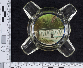
 Melbourne Water
Ashtray, Maroondah Dam, Healesville Souvenir, 1930s-1940s
The Maroondah System was first and foremost developed as a functional component of Melbourne's Water Supply System. In addition to functionality, the Melbourne and Metropolitan Board of Works (MMBW) envisioned the Maroondah Reserve to be enjoyed aesthetically and recreationally by the public. This souvenir illustrates the realisation of the Maroondah System as a local recreational and tourist attraction in the early 20th century. The Maroondah Reserve gardens were landscaped with English-style ornamental stonework, exotic trees, flower beds and rose gardens. All features of the water supply system became widely celebrated as beauty spots that continue to be very popular to this day with tourists and locals alike. This souvenir is a product of that flourishing tourist trade. These water supply sites continue to enhance Melbourne’s charm and liveability and are now recognised as places of cultural and historic significance.This souvenir item has been curated by Melbourne Water as it represents an important historical aspect of the organisation by demonstrating the popularity of its water asset sites as recreational places and tourist attractions, and although these sites are functional parts of the water supply system, they were also designed to be enjoyed by the public both aesthetically and recreationally. This Souvenir glass ashtray, used as a receptacle for ash from cigarettes, features a black and white photograph of The Maroondah Dam on the base, with text reading “Maroondah Dam, Healesville”. The ashtray is round in shape with three indents on the rim to place cigarettes. melbourne metropolitan board of works, mmbw, maroondah, dam, healesville, melbourne water, scenic view, souvenir, glass, ashtray -
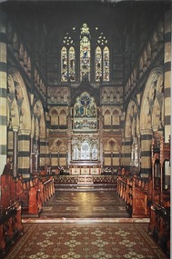
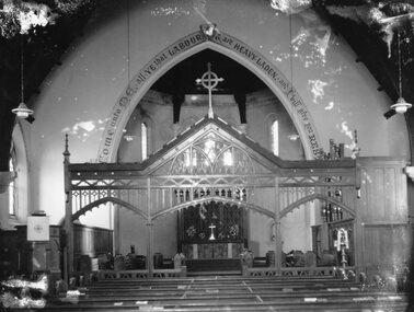 Stawell Historical Society Inc
Photograph, Holy Trinity Anglican Church's Sanctuary & Chancel Screen
Holy Trinity Anglican Church Sanctuary & Chancel Screenstawell religion -
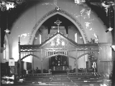 Stawell Historical Society Inc
Photograph, Holy Trinity Anglican Church's Sanctuary & Chancel Screen
Holy Trinity Anglican Church Sanctuary & Chancel Screenstawell religion -
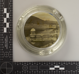
 Melbourne Water
Ashtray, Graceburn Weir, Healesville Souvenir, 1930s-1940s
The Maroondah System was first and foremost developed as a functional component of Melbourne's Water Supply System. In addition to functionality, the Melbourne and Metropolitan Board of Works (MMBW) envisioned the Maroondah Reserve to be enjoyed aesthetically and recreationally by the public. This souvenir illustrates the realisation of the Maroondah System as a local recreational and tourist attraction in the early 20th century. The Maroondah Reserve gardens were landscaped with English-style ornamental stonework, exotic trees, flower beds and rose gardens. All features of the water supply system became widely celebrated as beauty spots that continue to be very popular to this day with tourists and locals alike. This souvenir is a product of that flourishing tourist trade. These water supply sites continue to enhance Melbourne’s charm and liveability and are now recognised as places of cultural and historic significance.This souvenir item has been curated by Melbourne Water as it represents an important historical aspect of the organisation by demonstrating the popularity of its water asset sites as recreational places and tourist attractions, and although these sites are functional parts of the water supply system, they were also designed to be enjoyed by the public both aesthetically and recreationally.This Souvenir glass ashtray, used as a receptacle for ash from cigarettes, features a photograph of the Graceburn Weir on the base, with text reading “The Graceburn Weir, Healesville”. Rather small in size, this ashtray has a unique shape with four protruding glass points to place cigarettes. melbourne metropolitan board of works, mmbw, maroondah, dam, healesville, melbourne water, scenic view, souvenir, glass, ashtray, graceburnweir -
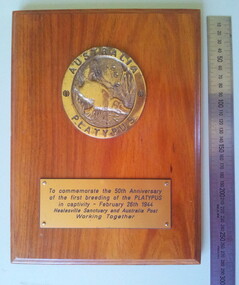 Healesville Sanctuary Heritage Centre
Plaque - Commemorative plaque: 50th anniversary of the first breeding of platypus, 1996
... Healesville-Sanctuary ...One of 2 identical wooden plaques created to commemorate the 50th Anniversary of the first breeding of a platypus in captivity. On the face of the plaque are 2 brass plates. The upper one is screwed to the wood and is slightly oval in shape and has a swimming platypus in the centre. The other plate, attached with 4 brass nails, describes the occasion and acknowledges the involvement of Australia Post. 1. AUSTRALIA / PLATYPUS 2 To commemorate the 50th Anniversay / of the first breeding of a PLATYPUS/ in captivity - February 26th 1944 / Healesville Sanctuary and Australia Post / Working Togetherplaque, platypus, breeding, first-time-breeding, healesville-sanctuary, anniversary -
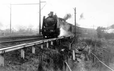 Surrey Hills Historical Society Collection
Photograph, Loco K176 at Surrey Hills on a vintage tour train to Healesville, 1 October 1966, 1 October 1966
We have an original B&W copy donated by Ian Barkla and a larger one copied by Ken Hall. The Barkla original has a sticker with his reference details on the back. The photo records a Vintage Train tour to Healesville on 1 October 1966. The Lilydale to Healesville line opened on 1 March 1889. The last steam train on the line ran in 1957 and the last passenger service was in 1980. The line reopened as a tourist railway in 2010. Although the photo was taken on a misty day, houses in Windsor Crescent can just be seen in the background. It is possibly Lorne Parade in the background with preparatory works for the 3rd rail line underway.A black and white photocopy of a steam train. One person is looking on from the left hand side of the photo. It's a misty day but houses in Windsor Crescent and the pedestrian overpass at Surrey Hills railway station can be seen.surrey hills railway station, windsor cresent, 1966, railfan tour, steam trains, vintage tour train -
Whitehorse Historical Society Inc.
Article, Festival to feature Sanctuary History, 2005
Article on 'Festival of Local History' held at Blackburn Lake Sanctuary with guest speakersArticle on 'Festival of Local History' held at Blackburn Lake Sanctuary with guest speakers Valda Arrowsmith from Whitehorse Historical Society; Lindsay McKirdy on the Adult Deaf Society; Wurundjeri elder Dot Peters and Blackburn artists Keith Dow. Photo of Elaine Boucher and Valda Arrowsmith at Heron Point, Blackburn LakeArticle on 'Festival of Local History' held at Blackburn Lake Sanctuary with guest speakersarrowsmith, valda, blackburn lake sanctuary, mckirdy, lindsay, peters, dot, dow, keith, boucher, elaine -
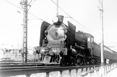 Surrey Hills Historical Society Collection
Photograph, Loco A2 932 at Surrey Hills on excursion train to Healesville
We have an original copy donated by Ian Barkla and a larger one copied by Ken Hall. The Ian Barkla original has a sticker with his reference details on the back. Taken on a Sunday excursion train to Healesville. Tentative date is 1963 / 1966.A black and white photocopy of a steam train. There are 2 houses located in Windsor Crescent in the background.surrey hills railway station, trains, steam trains, windsor crescent, ian r barkla, special rail excursions -
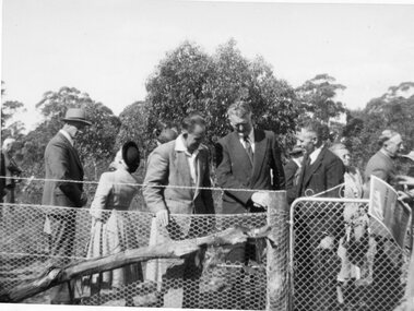 Stawell Historical Society Inc
Photograph, Stawell Field Naturalists at the opening of Three Jacks Wildflower Sanctuary 1954 -- 3 Photos
Stawell Field Naturalists – Opening of Three Jacks Wildflower Sanctuary Oct 1954. Three photographs.stawell -
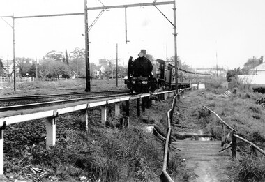 Surrey Hills Historical Society Collection
Photograph, Loco N 468 at Surrey Hills on Railfan Tour to Healesville for the Australia Railway Enthusiasts Group, 1 October 1966
We have an original copy donated by Iam Barkla and a larger one copied by Ken Hall. The Barkla original has a sticker with his reference details on the back. The occasion was a Railfan tour to Healesville for the Australian Railway Enthusiasts Group. Photo taken on 1 October 1966. A black and white photo of steam train. Some of the houses in WIndsor Crescent can be seen on the left hand side of the photograph; also some of the Union Road shops and the pedestrian overpass at the Surrey Hills station.surrey hills railway station, 1966, railfan tour, australia railway enthusiasts group, union road shops, windsor crescent -
 Whitehorse Historical Society Inc.
Book - History, Wandinong Sanctuary Advisory Committee, The Wandinong Story (2023), October 2023
The book describes the origins of Wandinong Sanctuary, Blackburn as a home for the Hookes family from 1913 and its transformation into a public park in 1973.Color Reprint of 110 pp, with a new front page and new color photographs of the vegetation. non-fictionThe book describes the origins of Wandinong Sanctuary, Blackburn as a home for the Hookes family from 1913 and its transformation into a public park in 1973.wandinong sanctuary, hooke janet, hooke arthur -
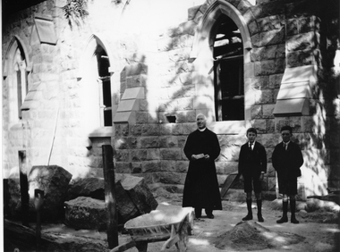 Stawell Historical Society Inc
Photograph, St. Patrick’s Church Sanctuary under construction with the priest and two boys watching
St. Patrick’s Church Sanctuary under construction with priest and two boys standing near workman's barrow and pile of sand.stawell religion -
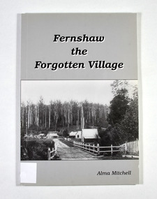 Marysville & District Historical Society
Book - Paperback book, Alma Mitchell, Fernshaw the Forgotten Village, 2001
The story of the village of Fernshaw between the dates of 1864 and 1890.Paperback. Front cover has the title and author's name. Also, a black and white photograph taken by John W. Lindt entitled 'First Glimpse of Fernshaw'.non-fictionThe story of the village of Fernshaw between the dates of 1864 and 1890.fernshaw, victoria, history, watts river, yarra track -
![Junction of the Rivers Yarra and Watt, Near Healesville / [by] Nicholas Caire, circa 1876](/media/collectors/550653872162f11fb04854aa/items/577740e5d0cdd10a5c0de011/item-media/57774153d0cdd10a5c0e0662/item-fit-380x285.jpg) Kew Historical Society Inc
Kew Historical Society IncPhotograph, Anglo-Australasian Photographic Company, Junction of the Rivers Yarra and Watt, Near Healesville, c. 1876
Nicholas Caire was born on Guernsey in the Channel Islands in 1837. He arrived in Adelaide with his parents in about 1860. In 1867, following photographic journeys in Gippsland, he opened a studio in Adelaide. From 1870 to 1876 he lived and worked in Talbot in Central Victoria. In 1876 he purchased T. F. Chuck's studios in the Royal Arcade Melbourne. In 1885, following the introduction of dry plate photography, he began a series of landscape series, which were commercially successful. As a photographer, he travelled extensively through Victoria, photographing places few of his contemporaries had previously seen. He died in 1918. Reference: Jack Cato, 'Caire, Nicholas John (1837–1918)', Australian Dictionary of Biography.An original, rare photograph from the series 'Views of Victoria: General Series' by the photographer, Nicholas Caire (1837-1918). The series of 60 photographs that comprise the series was issued c. 1876 and reinforced a neo-Romantic view of the Australian landscape to which a growing nationalist movement would respond. Nicholas Caire was active as a photographer in Australia from 1858 until his death in 1918. His vision of the Australian bush and pioneer life had a counterpart in the works of Henry Lawson and other nationalist poets, authors and painters.Albumen Silver Photograph, mounted on Board.printed in ink on support l.c.: JUNCTION OF THE RIVERS YARRA AND WATT, NEAR HEALESVILLE. / COPYRIGHT REGISTERED. printed in ink on support reverse c.: VIEWS OF VICTORIA. / (GENERAL SERIES.) / No. 3. / JUNCTION OF THE RIVERS YARRA AND WATT, NEAR HEALESVILLE / The junction is situated about 3 miles from Healesville, and 35 miles from the mouth of the Yarra. The souces / of the Watt are to be found at the head of the Black Spur, and, being fed by a number of creeks and springs, its / waters gain considerable force for several miles before joining those of the Yarra. The "Old Bridge," at the junction, / is the name given to this crossing-place, which has been partly swept away by late floods. The depth of the Yarra here / is from 15 to 20 feet; that of the Watt, about 10 feet. printed in ink on support reverse l.c.l.: J.W. FORBES, Agent, printed in ink on support reverse l.c.: ANGLO-AUSTRALASIAN PHOTOGRAPHIC COMPANY, MELBOURNE. printed in ink on support reverse l.c.r.: 10 Temple Court, Collins Street West.nicholas caire (1837-1918), yarra river, watt river, bridge, wooden bridge, healesville -
 Kew Historical Society Inc
Postcard, Paul Ahearne, St Paul's Cathedral, Sanctuary, 1950-1965
The Kew Historical Society's postcard collection includes views of Kew, Melbourne and Greater Melbourne as well as those including overseas scenes sent or received from Europe or the Middle East. They date from the 1890s to the 2000s. These postcards may or may not include the name of the publisher or printer. A number of the cards were published as parts of popular series. A way of dating early postcards is to identify whether the reverse was divided by a central line which became the norm after 1902 in the United Kingdom. However, other postcards produced after this date do not always conform to this print layout.Colour postcard of the interior of St Paul's Cathedral, Melbourne by Max Ahearne, Renwick Pride, Gravure Print.St Paul's Cathedral, Melbourne, Australia - Sanctuary / Foundation stone, 1880; Consecrated 1891; Spires computed 1931. Exterior length, 276 feet. Moorhouse spire, 317 feet in height. Architect, William Butterfield, 1814-1900. / Colour photo by Max Ahearne, Renwick Pride, Gravure Print.st paul's cathedral -- melbourne (vic.), postcards -- churches -- melbourne (vic.) -
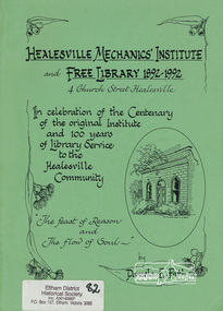 Eltham District Historical Society Inc
Book, Healesville Mechanics' Institute and Free Library 1892-1992, 4 Church Street, Healesville : in celebration of the centenary of the original institute building and 100 years of library service to the Healesville community : "the feast of reason and the flow of soul" / Pamela E. Firth, 1992
Paperback; xvi, 70 p. : ill. ; 30 cm.ISBN 0646113569mechanics' institute, healesville, libraries