Showing 182 items matching "historical geography"
-
 Port Melbourne Historical & Preservation Society
Document, The Formation of Sandridge - Port Melbourne, 1980s
Wendy has suggested that the document may have been written by June Kirby, the History LibrarianThe Formation of Sandridge - Port Melbourne Five pages with all printing in black capital letters. A Hstory of Port Melbourne from the 1830s to the time of writing, thought to be in 1980s. Emphasis is on th 1800s and the effect of the geographical features of the Port Phillip District on the developmentnatural environment, built environment, history, sandridge, june kirby -
 Koo Wee Rup Swamp Historical Society
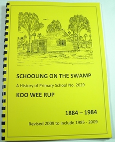
Book, Koo Wee Rup Primary School, Schooling On The Swamp, November 2009
History of Koo Wee Rup Primary School. Includes information about other schools (past and present) in Koo Wee Rup Swamp area : Bayles, Caldermeade, Cardinia, Catani, Cora Lynn, Dalmore East, Iona, Island Road, Koo Wee Rup North, Koo Wee Rup South, Heath Hill, Lang Lang, Protectors Plains, Modella, Tooradin, Tooradin North, Yannathan, Yannathan South. School Centenary History updated and expanded for 125 anniversary of Koo Wee Rup Primary School (1884-2009) Includes brief account of geography of Koo Wee Rup Swamp, and local indigenous people.A history of Primary School No. 2629, Koo Wee Rup : 1884 - 2009 (Revised for school 125th. anniversary - November 2009) compiled by Don Jewell. 62 pages, A4, plastic spring binding.koo wee rup primary school, centenary history -
 Bendigo Historical Society Inc.
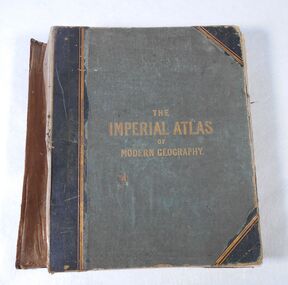
Book - Atlas, The Imperial Atlas of Modern Geography, 1860
Publisher Walter Graham Blackie (1816-1906) began as a letterpress operator, printer and publisher. He married Marion Brodie 16/4/1846. In 185, his successful business in Glasgow, employed 60 men and 40 boys.The Imperial Atlas of Modern Geography published in London by Blackie and Son, Warwick Square, E.C.; Glasgow and Edinburgh in 1860 MDCCCLX. The atlas includes an extensive series of maps embracing the most recent discoveries and the latest political divisions of territory in all parts of the world compiled and engraved from the most authentic sources. world maps, index -
 Bendigo Historical Society Inc.
Photograph - LYDIA COLLECTION COLLECTION; LIFE IN OTHER LANDS
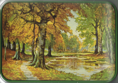
A green tin with a pictures of trees on the lid. The words 'Autumn Glory' are also written on the lid - 1. Series 1 - 12 'Life in other Lands.' A set of six photographs in each envelope. From pictures painted by E .S. Hardy. The All-British Picture Company Ltd., The Sunday School Union, 57/59 Ludgate Hill. London, E.C.4. 2. One envelope containing beautiful coloured reproductions of the paintings by E. Stuart Hardy. Titled 'Early Saints of History.' A.B. Shaw & Co., Ltd. 3, Creed Lane, Ludgate Hill, London, E.C.4. 3. Four black and white postcard size photographs of the process of making Guinness in a plain envelope.place, tin, lydia chancellor collection, collection, tin, photograph, photo, photos, photographs, guinness manufacturing, history, early saints of history, saints, st. columba, st. patrick, caedmon, st. augustine, st. benedict, st. francis, life in other lands, china, japan, africa, eskimos, inuits, south seas, india, geography, person, people, e. s. hardy, art, artwork, painting, place, societies -
 Bendigo Historical Society Inc.
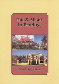
Book - OUT & ABOUT IN BENDIGO, 2007
Out & About in Bendigo. History of Bendigo and District. Plaques, monuments and head stones. Photographs. ISBN:978 1 875 342 69 3. Inscriptions: Ken Arnold December 2007.Ken & Jean Arnoldbendigo, history, bendigo, bendigo and district, plaques monuments headstones poppet heads fortuna geographical centre of victoria memorials -
Bendigo Historical Society Inc.
Map - VICTORIA, Circa 1926
Map: Map showing Counties, including Railway lines and Geographic features. Compiled and engraved at the Department of Lands and Survey Melbourne, Revised October 1926 ( number 184 in Map Cupboard 1)map, victoria, counties, counties of victoria, geographic features -
 Monbulk RSL Sub Branch
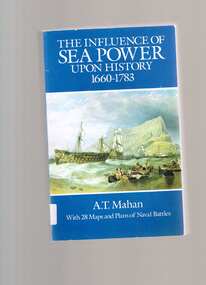
Book, Dover Publications, The influence of sea power upon history, 1660-1783, 1987
Though technological advances over the last century have revolutionized warfare, The Influence of Sea Power upon History, 1660-1783 remains a classic text on the history, strategy, and comprehension of commercial and military command of the high seas. The first president of the U.S. Naval War College, Alfred Thayer Mahan demonstrates through historical examples that the rise and fall of sea power and the wealth of nations have always been linked with commercial and military command of the sea. Mahan describes successful naval strategies employed in the past--from Greek and Roman times through the Napoleonic Wars--with an intense focus on England's rise as a sea power in the eighteenth century. This book provides not only an overview of naval tactics but also a lucid exposition of geographic, economic, and social factors governing the maintenance of sea power.Index, bib, ill, maps, p.557.non-fictionThough technological advances over the last century have revolutionized warfare, The Influence of Sea Power upon History, 1660-1783 remains a classic text on the history, strategy, and comprehension of commercial and military command of the high seas. The first president of the U.S. Naval War College, Alfred Thayer Mahan demonstrates through historical examples that the rise and fall of sea power and the wealth of nations have always been linked with commercial and military command of the sea. Mahan describes successful naval strategies employed in the past--from Greek and Roman times through the Napoleonic Wars--with an intense focus on England's rise as a sea power in the eighteenth century. This book provides not only an overview of naval tactics but also a lucid exposition of geographic, economic, and social factors governing the maintenance of sea power.naval history - modern, sea power -
 Monbulk RSL Sub Branch
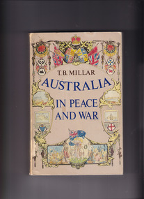
Book, Australian National University Press, Australia in peace and war, 1978
AUSTRALIA IN PEACE AND WAR is the first work to trace the development of Australia’s external relations from their colonial origins to the present. It shows how successive Australian governments have seen the world, what their attitudes have been, their actions and (much more often) their reactions. This important and controversial book details the successes and failures of Australian foreign policy over two centuries. It shows how geographical aspects of the world's largest island, anchored off the south-east corner of Asia, have increasingly impinged on perceptions and attitudes historically derived from Europe. It pleads for recognition that Australia can adapt the best of its European traditions in coming to terms with and helping to shape its Asia-Pacific environment.Index, bib, p.578.non-fictionAUSTRALIA IN PEACE AND WAR is the first work to trace the development of Australia’s external relations from their colonial origins to the present. It shows how successive Australian governments have seen the world, what their attitudes have been, their actions and (much more often) their reactions. This important and controversial book details the successes and failures of Australian foreign policy over two centuries. It shows how geographical aspects of the world's largest island, anchored off the south-east corner of Asia, have increasingly impinged on perceptions and attitudes historically derived from Europe. It pleads for recognition that Australia can adapt the best of its European traditions in coming to terms with and helping to shape its Asia-Pacific environment. australia - foreign relations, australia - history - military -
 Monbulk RSL Sub Branch
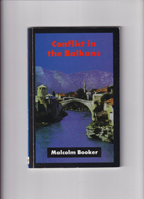
Book, Malcolm Booker, Conflict in the Balkans, 1994
Historical account of the Balkan area - includes Slovenia, Croatia, Serbia, Bulgaria, Bosnia, Herzegovina, Montenegro, Albania and Macadonia - over the last 2000 years. Considers its geographical position as a corridor from central Europe and inner Asia to the Mediterranean and the ordeals suffered by the peoples of the Balkans in the light of European competetion for access. Includes a list of important dates, a glossary and bibliography and a fold-out map of the area.Bib, maps, p.70.non-fictionHistorical account of the Balkan area - includes Slovenia, Croatia, Serbia, Bulgaria, Bosnia, Herzegovina, Montenegro, Albania and Macadonia - over the last 2000 years. Considers its geographical position as a corridor from central Europe and inner Asia to the Mediterranean and the ordeals suffered by the peoples of the Balkans in the light of European competetion for access. Includes a list of important dates, a glossary and bibliography and a fold-out map of the area. balkan peninsula - history, armed conflict - history and teaching -
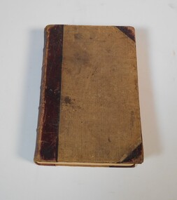
 Bendigo Historical Society Inc.
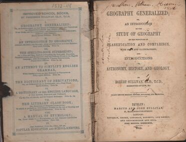
Book - HARRIS COLLECTION: GEOGRAPHY GENERALIZED
Book, 382 pages, brown board cover: ' Geography Generalized or an Introduction to the Study of Geography on the principles of classification and comparison with many illustrations through maps and illustrations' On front page in black pen ' Jonathan William Harris 1886' and ' Australia' written twice in same. Over page 'Jonathan W. Harris, his uncle. A gift from P.J. Murphy, 34 Little Oxford St., Collingwood. Jonathan W. Harris, August 26th, 1873' Published by Marcus and John Sullivan, 27 Marlborough Street, London. 1864Robert Sullivan, Barrister at Law.person, individual, jonathan harris, axedale -
Clunes Museum
Book, Jan D Clark, MONASH UNIVERSITY NUMBER 37 ABORIGINAL LANGUAGES AND CLANS
HISTORICAL ATLAS OF WESTERN AND CENTRAL VICTORIA, AUSTRALIA 1800-1900 ON PAGE ONE: TO THE CLUNSES MUSEUM WITH BEST WISHES "JAN CLARK" 5 OCTOBER 2003aboriginal languages - of western and central victoria, aboriginal clans -
Tatura Irrigation & Wartime Camps Museum
Poster, POW and Internment Camps Across Australia, 2019
Poster depicts scenes of the various internment camps around Australia, including camp layouts and geographic information. Made as part of the project "Temporal Cities" led by Professor Anoma Pieris.1 laminated sheet of paper depicting POW and internment camps across Australia. 1939-1947. Is contained in a large white cylinder. Poster is in a thin black metal frame with black mat and glass.Labelled on back with copy of information in historical information.professor anoma pieris, university of melbourne, camp architecture -
 Victorian Aboriginal Corporation for Languages
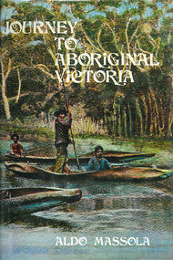
Book, Aldo Massola, Journey to Aboriginal Victoria, 1969
Looks at the Aboriginal community from the time of white contact, across many parts of Victoria. Chap.1; Melbourne - early missions, camp of Native Police, corroboree trees, canoe trees, grave &? headstone of Derrimut; quarries at Keilor, excavation sites at Green Gully &? Keilor; quarry at Mt. William, notes on inheritance of quarries Coranderrk settlement - Barraks grave, notes on his life; Chap.2; Geelong - Yawangi group of the Wothowurong tribe, camping grounds in area quarries; Notes on William Buckley, Gellibrand (a notable Aboriginal), graves in the Western Cemetery; Chap.3; Colac - war between Colac &? Geelong tribes; Mission at Birregurra, reason for failure of Buntingdale Mission; brass plate to Coc-coc-coine; reserve at Elliminyt, native ovens, camp sites, initiation site &? ritual; quarry sites, axegrinding factory, rock pecking &? engraving; dried hand &? 3 Aboriginal skulls found; Chap.4; The south-west coast - middens, camp sites notes on Framlingham Stn., fish traps at Tyrendarra; Chap.5; The far west - massacres of Aborigines near Casterton; camp sites, oven mounds; the first cricket team formed; Aboriginal cemetery; Chap.6; Hamilton - camps; Mount Rouse Station, axegrinding grooves at Nareeb Nareeb, shelters described, fish traps, massacre at Lake Condah; mission; canoes; Chap.7; Camperdown - legend about Lake Bullen Merri; obelisk erected in memory of Aborigines of district especially chief Wombeetch Puyuun; Jarcoort tribe; fish weirs, camps, intertribal fights between Booluc-burrers, Jarcoorts &? Ellengermote groups; bartering place at Mount Noorat; articles traded, legend of Flat-Top Hill; Chap.8; Ballarat - camp at Lake Wendouree; White Stone Lagoon; legends concerning Mt. Buninyong &? waterfalls at Lal-lal; camp sites; pygmy-type implements near Meredith, quarry at Glue Pot Rocks near Durdidwarrah; brass plate of King Billy; Chap.9; Ararat - Tjapwurong territory; camp sites, quarries, shield &? canoe trees; Bunyip belief at Lake Buninjon of Muk-jarawaint &? Pirtkopen-noot tribes, gives legend; stone implements; mill stones; fish weirs; stone arrangement near Lake Wongan; ground drawing of a bunyip, paintings in rock shelter near Mt. Langi Ghiran; Chap.10; Maryborough - camps, oven mounds, rock wells, stone arrangement at Carisbrook; camp sites at Mt. Franklin; Chap.11; Charlton - belief in Mindye (snake); canoe trees, ovens, camp sites, water holes, rock wells, stone implements; method of rainmaking; Chap.12; Horsham-Stawell, The Wimmera - Wotjobaluk land; camps, fish traps at Toolondo; Black Range cave paintings, Flat Rock shelters (detailed account of these paintings); Bunjils Cave; Chap.13; Horsham-Stawell, The Mallee - camp sites, implements; Ebenezer Mission, Willie Wimmera taken to England by Rev. Chase to become a missionary, died in England; Chap.14; The Murray River, Mildura Swan Hill - Battle of the Rufus; ceremonial ground, Lake Gol Gol, canoe &? shield trees; stone implements; camp sites, fire place arrangements; fish traps; oven mounds; Chap.15; The Murray River, Swan Hill-Echuca - legend about Lake Boga; camps, oven mounds, the Cohuna skull, Kow Swamp, method of burial; Chap.16; Shepparton ovens; brass plates of King Paddy of Kotupna &? King Tattambo of Mulka Stn., native well, camps; Chap.17; Wangaratta -camps, quarry, rock holes, the Faithful massacre; grinding rocks at Earlston; Chap.18; The High Plains - Ya-itma-thang; camps, Bogong moth feasts, native paths for trade &? intertribal fights, articles traded; painted shelters; Koetong Ck. Valley, near Mt. Pilot &? near Barwidgee Ck.; Chap.19; Dandenong - water holes, list of 8 holes in Beaumaris - Black Rock area; camps, middens, stone implements (microliths), legend of Angels Cave, stone axes, Native Police Force, Narre Narre Warren Station, legend about rocks on Bald Hill, kangaroo totemic site; Chap.20; Wonthaggi- Yarram - natives visit Phillip Is., murder of William Cook and Yankee by five Tasmanians (listed as Bon Small Boy, Jack Napoleon Timninaparewa, Fanny Waterpoordeyer, Matilda Nattopolenimma and Truganini) near Cape Patterson, men; camp sites, middens, legend of White Rock; Chap.21; Sale - Bairnsdale, The Lakes Country middens, camps; legend at Wulrunjeri; story of a white woman supposedly living with with the Tutangolung tribe, efforts made to prove story; canoe trees; Chap.22; Sale-Bairnsdale, The Inland Braiakolung tribe, camps, implements, canoe &? shield trees; Ramahyuck Mission, grinding rocks, fights with Omeo tribe; native tracks, death through enemy magic - procedure, belief in ghosts; Chap.23; Lakes Entrance and the Country to the east - Kroatungolung people, legend of Kalimna Valley; camps, stones of Nargun, bunyip, devils at Lake Tyers, excavation at Buchan, carbon dates; middens, ochre at Cape Conrad, stone fish-hook file at Thurra River; note on Bidwel tribe; Each chapter gives historical details, early contacts, relationships with settlers; Aboriginal place names and detailed description of sites and geographical features.b&w photographs, b&w illustrations, colour illustrationsgeelong, colac, hamilton, camperdown, ballarat, ararat, maryborough, charlton, horsham, stawell, murray river, shepparton, wangaratta, dandenong, wonthaggi, yarram, sale, bairnsdale, lakes entrance -
 Victorian Aboriginal Corporation for Languages
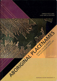
Book, Harold Koch, Aboriginal placenames : naming and re-naming the Australian landscape, 2009
"Aboriginal approaches to the naming of places across Australia differ radically from the official introduced Anglo-Australian system. However, many of these earlier names have been incorporated into contemporary nomenclature, with considerable reinterpretations of their function and form. Recently, state jurisdictions have encouraged the adoption of a greater number of Indigenous names, sometimes alongside the accepted Anglo-Australian terms, around Sydney Harbour, for example. In some cases, the use of an introduced name, such as Gove, has been contested by local Indigenous people." "The 19 studies brought together in this book present an overview of current issues involving Indigenous placenames across the whole of Australia, drawing on the disciplines of geography, linguistics, history, and anthropology. They include meticulous studies of historical records, and perspectives stemming from contemporary Indigenous communities. The book includes a wealth of documentary information on some 400 specific placenames, including those of Sydney Harbour, the Blue Mountains, Canberra, western Victoria, the Lake Eyre district, the Victoria River District, and southwestern Cape York Peninsula." -- Publisher description. Contents: Introduction: Old and new aspects of Indigenous place-naming /? Harold Koch and Luise Hercus NSW &? ACT: 1. Aboriginal placenames around Port Jackson and Botany Bay, New South Wales, Australia: sources and uncertainties /? Val Attenbrow 2. Reinstating Aboriginal placenames around Port Jackson and Botany Bay /? Jakelin Troy and Michael Walsh 3. The recognition of Aboriginal placenames in New South Wales /? Greg Windsor 4. New insights into Gundungurra place naming /? Jim Smith 5. The methodology of reconstructing Indigenous placenames: Australian Capital Territory and south-eastern New South Wales /? Harold Koch Victoria: 6. Toponymic books and the representation of Indigenous identities /? Laura Kostanski 7. Reviving old Indigenous names for new purposes /? Laura Kostanski and Ian D. Clark 8. Reconstruction of Aboriginal microtoponymy in western and central Victoria: case studies from Tower Hill, the Hopkins River, and Lake Boga /? Ian Clark South Australia &? Central Australia: 'Aboriginal names of places in southern South Australia': placenames in the Norman B.Tindale collection of papers /? Paul Monaghan 10. Why Mulligan is not just another Irish name: Lake Callabonna, South Australia /? J.C. McEntee 11. Murkarra, a landscape nearly forgotten: the Arabana country of the noxious insects, north and northwest of Lake Eyre /? Luise Hercus 12. Some area names in the far north-east of South Australia /? Luise Hercus 13. Placenames of central Australia: European records and recent experience /? Richard Kimber Northern Australia: 14. Naming Bardi places /? Claire Bowern 15. Dog-people: the meaning of a north Kimberley story /? Mark Clendon 16. 'Where the spear sticks up': the variety of locatives in placenames in the Victoria River District, Northern Territory /? Patrick McConvell 17. 'This place already has a name' /? Melanie Wilkinson, Dr R. Marika and Nancy M. Williams 18. Manankurra: what's in a name? placenames and emotional geographies /? John J. Bradley and Amanda Kearney 19. Kurtjar placenames /? Paul Black.Maps, b&w photographs, tables, word listsaustralian placenames, sociolinguistics, linguistics, anthropology, sydney harbour placenames, blue mountains placenames, canberra placenames, western victoria placenames, lake eyre placenames, victoria river district placenames, cape york peninsula placenames -
Clunes Museum
Book, IAN D. CLARK. 1990, ABORIGINAL LANGUAGES AND CLANS, 1990
Full bibliographic detail on Dhauwurd wurrung, Djab wurrung, Djadja wurrung, Djargurd wurrung; Gadubanud; Girai wurrung; Gulidjan Jardwadjarli; Wada wurrung, Wergaia; East Kulin, Woi wurrung, Daung wurrung, Bun wurrung, Ngurai-illam wurrung, Barababaraba, Wadiwadi; Wembawemba; history of contact and settlement; effects on tradition; disruption of lifestyle; clan/subsection information; research based solely on archival sources.A MONASH UNIVERSITY PUBLICATION IN GEOGRAPHYnon-fictionFull bibliographic detail on Dhauwurd wurrung, Djab wurrung, Djadja wurrung, Djargurd wurrung; Gadubanud; Girai wurrung; Gulidjan Jardwadjarli; Wada wurrung, Wergaia; East Kulin, Woi wurrung, Daung wurrung, Bun wurrung, Ngurai-illam wurrung, Barababaraba, Wadiwadi; Wembawemba; history of contact and settlement; effects on tradition; disruption of lifestyle; clan/subsection information; research based solely on archival sources.book, aboriginal languages and clans -
 Wonthaggi & District Historical Society
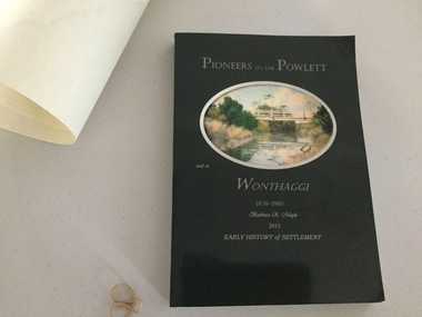
Book and Map, Barbara Moyle, Pioneers on tthe Powlett and at Wonthaggi 1878-1910, 2015
Book - families social histories, maps, photograps Map - block numbers town names physical / geographical featuresFarming and social history of pioneers of the Powlett River are prior to the establishment of the State Coal Mine at Wonthaggi. Significant land marks, buildings and photographs are included. Dark green cover with oval artists impression of Powlett river and bridge Associated map which covers the parishes plus key places of interestlPioneers on the Powlett and at Wonthaggi 1878-1910 Barbara R Moyle 2015 Early History of Settlement Map - Parish names, significant sitesfarming, pioneers of wonthaggi and district, wonthaggi families -
Stawell Historical Society Inc
Book - School Book, The Austral Geography for class VI
Dulcie Baily Born Stawell 1919 Married Murris Trickey 1941 School Book Grade 6Blue Fabric, Card, paperDulcie Bailey PRICE 1/- The AUSTRAL GEOGRAPHY FOR CLASS VI. By J.W. Gregory D,Sc., F.R.S. ?? Professor of of Geology in teh University of Melbourne Melbourne Christchurch, Wellington, Durbin, ?? & London Whitcombe & Thomas Limited All Rights Reserved. J.W. Gregory D.Sc F.R.S. education, primary school -
 Stawell Historical Society Inc
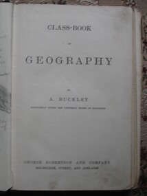
Book, A. Buckley, Class Book of Geography by A Buckley, 1888
Green Embossed Cover with cover framed by featuring stars in all corners surrounded by circles Title in centre. Clear tape on Spine.Hand written. To Ethel from Neil Feb 13th 1893. Ethel L (Struck though) Phillips State School 502 13 Feb 1893stawell education -
Melbourne Athenaeum Archives
internet printout, Royal Historical Society Victoria - Invitation to Third Triennial meeting to mark Columbus' Discovery of America, 1492 held at Melbourne Athenaeum, October 12 1892 Royal Geographical Society of Australasia, Victorian Branch: Album
-
Koorie Heritage Trust
Book, Bader, Frances, Naming St. Kilda, 2007
Mentions the indigenous inhabitants of the area.i - vi; 214 P.; ports,; facs.; refs.; bib.; Mentions the indigenous inhabitants of the area. names, geographical -- victoria -- st. kilda. | st. kilda (vic.) -- name -- history. -
Whitehorse Historical Society Inc.
Document, Mountains District Police, 1991
History of Mountains District Police which comprises 2 geographical positions.History of Mountains District Police which comprises 2 geographical positions. Also includes history of Blackburn and Nunawading Police Stations.History of Mountains District Police which comprises 2 geographical positions. police, mountains district police, blackburn police station, nunawading police station -
Whitehorse Historical Society Inc.
Map, Nunawading Planning Scheme, 7/06/1994 12:00:00 AM
Local Section maps 1 - 4 with index. Geographical information system land Information Branch. Scale 1:10,000 Shows zoning under planning scheme.Local Section maps 1 - 4 with index. Geographical information system land Information Branch. Scale 1:10,000 Shows zoning under planning scheme.Local Section maps 1 - 4 with index. Geographical information system land Information Branch. Scale 1:10,000 Shows zoning under planning scheme.blackburn, blackburn north, blackburn south, forest hill, heatherdale, maps, nunawading, vermont, vermont south, town planning, burwood east, laburnum -
 Whitehorse Historical Society Inc.
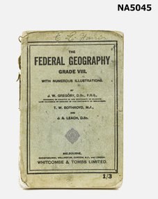
Book - School textbook, The Federal Geography Grade VIII
UnknownExample of school textbook (C1950's?) undated.Comprehensive Grade VIII school textbook for Geography.E. C. Harristextbook, victorian, grade viii -
 Rutherglen Historical Society
Map, 1908
This is a map produced as part of a book entitled.. It is also stamped on the back in blue ink with an oval ring and the words North of England Institute. Newcastle. Mining & Meterolgical Faculty. Purchased on 23rd July 2017 by the Society after research by member Simon Killeen. Mining map of one of the first mines in Rutherglen area ( Chiltern West)Cream paper, black printing, rectangle with a drawingGeographical Survey of Victoria, Memoir, No6. Plate XX Plan of Underground Workings CHILTERN VALLEY CONSOLS MINE, RUTHERGLEN, PARISH OF CHILTERN WESTgold, rutherglen, mining, chiltern, underground mine map, geological survey, reef drives -
 Numurkah & District Historical Society
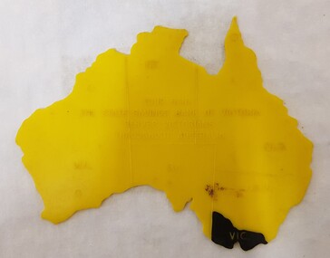
Equipment - Plastic stencil map/shape of Austalia
Yellow plastic stencil in the shape of Australia, states marked on the map, Victoria painted in blackState Savings Bank of Victoraeducation, school, geography, australia, stencil, drawing -
 Numurkah & District Historical Society
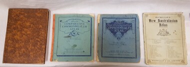
Book - School Atlases, Macmillan's New Australian Atlas / Phillip's New Comparitive Commonwealth Atlas (2) / The New Pictorial Atlas of the World
4 x World Atlas book. Cardboard covers & paper pagessee photoeducation, school, atlas, geography -
 Bendigo Historical Society Inc.
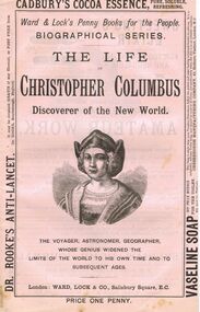
Book - LYDIA CHANCELLOR COLLECTION: THE LIFE OF CHRISTOPHER COLUMBUS
A book titled ' The Life of Christopher Columbus. Discoverer of the New World.' 'The Voyager, Astronomer, Geographer, whose genius widened the limits of the World to his own time and to subsequent ages.' Published London: Ward, Lock & Co., Salisbury Square, E.C. 369 - 383 pgs. This booklet is one of a series of 53 ' Ward & Lock's Penny Books for the People.' ' Biographical Series.' Price one penny. There are also advertisements of note.books, biography, christopher columbus, lydia chancellor, collection, history, explorers, famous people, astronomy, geography, exploration, christopher columbus, biographical series, biographies, ward & lock's penny books for the people, male, person individual, penny books, advertisements -
 Bendigo Historical Society Inc.
Book - Geographical dictionary
The Gazetteer presents an extensive a to z list of Victorian towns and villages, lakes, rivers and creeks, islands, bays, hills and mountains, runs and other localities and features. Entries include latitude and longitude, populations, proximity to other towns, local industries, coach and mail runs, hotels, churches and schools.Bailliere's Victorian Gazetteer and road guide containing the most recent and accurate information as to every place in the colony. Brown hardcover book, on the spine: Victorian Gazetteer with map 1865. The first and last pages are advertisements. The book has 442 pages listing every place in the colony. The map is not included. Compiled by Robert P. Whitworth. Published by Bailliere, Regent Street Unreadable name on first page and the name of F. Houston in blue pen on first page geographic dictionary, colony of victoria -
 Bendigo Historical Society Inc.
Slide - Bendigo College of Advanced Education - Landscaping, about 1986
Bendigo TAFE is a regional provider of vocational education, training and assessment services, located in northern and central Victoria, Australia. The institute has been in operation in various guises since 1854. The institute was known as the Loddon Campaspe Institute of TAFE from 1987 to 1990, Bendigo Regional Institute of TAFE (BRIT) from 1990 to 2009, before becoming Bendigo TAFE in 2009. Bendigo TAFE services a significant geographical area of approximately 25,000 square kilometres in central and northern Victoria, with a local population of 220,000. In May 2014, Bendigo TAFE announced that it would merge with the Melbourne-based Kangan Institute to form Bendigo Kangan Institute, however both institutes retain their existing branding.Bendigo College of Advanced Education (BCAE) early years - 24 slides of Landscaping at the new premises in Nolan Street Bendigo (Now the Bendigo Tertiary and Further Education (TAFE). history, bendigo, bendigo college of advanced education, bcae, landscaping, bendigo tafe -
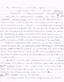 Bendigo Historical Society Inc.
Document - PETER ELLIS COLLECTION: NOTES FROM BENDIGO ADVERTISER
Notes, some taken from the Bendigo Advertiser 10/71895, 12/7/1895, and 23/12/1885. Items mentioned are: Snakes of the Whipstick, Science Society, Elliott's Reef Company, Sandhurst Museum, Snakes common to Bendigo, Snake Bite, The Whipstick Water Supply - Bendigo Advertiser 23/12/1885, Are Slides guides to Mining, Mr Wilson Froggatt's return from New Guinea, Death and a short obituary of Dr MacGillivray, Some of the work of watercolour and pencil artist, Mr R H Nancarrow, of Neilborough, and a description of Dr Mac's new residence on the lower corner of Rowan and Forest Streets.bendigo, history, early bendigo, peter ellis collection, bendigo advertiser 10/7/95 pg 3 & 12/7/95, snakes of the whipstick, school of mines, r brough smyth, science society, dr macgillivray, eaglehawk prospecting committee, elliott's reef company, sandhurst museum, prof halford, mr r bloomfield rees, professor mccoy, mr vahland, mr robshaw, the whipstick water supply, bendigo advertiser 23/12/1885, mr nancarrow, mr wilson froggatt, sir edmund strickland, geographical society, paul howard, isabella shields, sandhurst mining board, mr r h nancarrow - artist - watercolour & pencil, arnott's patent ventilators