Showing 348 items matching "homestead road"
-
 Greensborough Historical Society
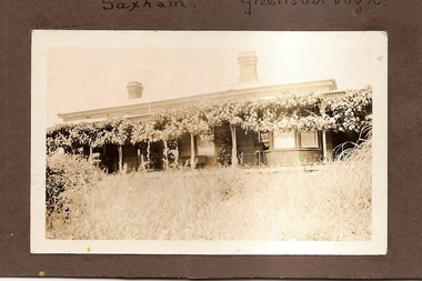
Photograph - Digital Image, Saxam, now Churinga, 1896c
"Saxam" was the home of the Kaye family (1886-1888) then William Santon, a former councillor and Mayor of Heidelberg. Saxam Homestead is a distinctive and substantial timber homestead built in the late 1880s as one of the notable rural properties in the St Helena area. In 2014 the house still stands but is in poor condition with most interior features removed. A significant Greensborough house.Digital copy of black and white photograph. saxam, churinga, william santon -
 Greensborough Historical Society
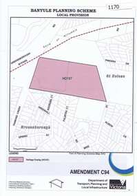
Map, Saxam Heritage Overlay, 2011_
"Saxam" was the home of the Kaye family (1886-1888) then William Santon, a former councillor and Mayor of Heidelberg. Saxam Homestead is a distinctive and substantial timber homestead built in the late 1880s as one of the notable rural properties in the St Helena area. In 2014 the house still stands but is in poor condition with most interior features removed. The site had a heritage overlay as shown. The overlay was reduced in 2014 to protect the house while allowing residential development on the site.Saxam is one of the only remaining farmhouses in the Greensborough area.Copy of map and planning scheme.saxam -
 Greensborough Historical Society
Article, Noel Withers, Willis Vale Homestead 1841-1962, 1841-1962
Willis Vale was built in 1841 by George Maygar and named after his wife's maiden name of Willis. This article outlines the lessees and owners of the property, Robert Whatmough (1863) and Charles Partington (1878).Outlines the history of this Greensborough property.3 pages, text and black and white imageswillis vale, robert whatmough, george maygar, charles partington -
 Greensborough Historical Society
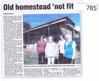
Newspaper clipping, Old homestead 'not fit', 2000c
The article is about the demise of the homestead formerly known as "Saxam"."Saxam" was the home of William Santon, a former councillor and Mayor of the Heidelberg City Council. He was also a foundation member of Greensborough Football club in 1922.A short article featuring a colour photograph. william santon, greensborough football club, greensborough hotel, churinga, st john of god, city of heidelberg, saxam -
 Greensborough Historical Society
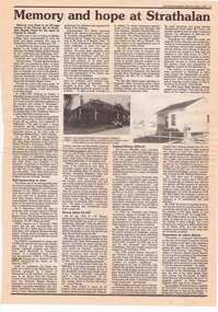
Newspaper clipping, Victorian Baptist Witness, Memory and hope at Strathalan, 1995_03
Review and extracts from "Memory and Hope", an 87 page history of Strathalan Baptist Home for the aged, by Damian X. Powell, from purchase in 1906/7 of the Strathalan homestead and 15 acres of land in Macleod by the Victorian Baptist Union to 1958 when further development of the site was halted.1 page, text and black and white images.strathalan baptist home for the aged, macleod -
 Greensborough Historical Society
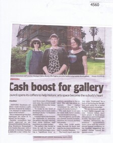
Newspaper Clipping, Cash boost for gallery, 05/04/2017
The art gallery at historic Bundoora Homestead could receive a cash injection of almost $1 million in an attempt to make it the heart of the suburb. News article 1 page, black text, colour image.bundoora homestead, art gallery, funding, darebin council -
 Greensborough Historical Society
Photograph - Digital Image, Willis Vale site, 2014_
Photograph of the site of the 'Willis Vale' homestead, home of the Partington family. The derelict Willis Vale house was destroyed in 1964 when a fire originating from North Plenty Gorge - Kurrak Road - was lit by two teenage boys and made its way several kilometres down to Partington's Flat Greensborough.Digital copy of colour photograph."This house is where Willis Vale homestead was on Partingtons Flat"partington family, willis vale -
 Greensborough Historical Society
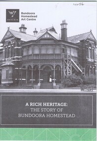
Pamphlet, City of Darebin, A Rich heritage: the story of Bundoora Homestead, 2016_
History of Bundoora Homestead, from its initial use by John Matthew Vincent Smith as a horse and cattle stud, and later as a convalescent farm and repatriation hospital until its ownership by Darebin City Council and restoration.10 p. pamphlet, col. & black & white photographs and plansbundoora homestead -
 Greensborough Historical Society
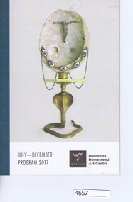
Pamphlet, City of Darebin, Bundoora Homestead Art Centre July-December 2017 Program, 2017_07
Program of activities and displays held at Bundoora Homestead Art Centre in 2017.10 p. pamphlet, col. illus.bundoora homestead -
 Greensborough Historical Society
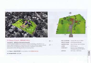
Newspaper Clipping, The Weekly Review, 'Woodlands': 11 Doon Court Briar Hill, 05/07/2017
Sale notice for "Woodlands", 1800s homestead on 8413 sqm at 11 Doon Court Briar Hill. Agent: Miles Real Estate. Home of Francis Wellington Were in the 1920'sRed and black print, colour photograph.doon court briar hill -
 Greensborough Historical Society
Article, Avril Salter, Yallambie Homestead, by Avril Salter, 1970_
This history of Yallambie Homestead was written by Avril Salter in 1970. It covers the property since its original land grant, to the homestead until and after its alteration in 1923. A history of one of the areas homesteads which is still in use today.Research article, 43 pages, text only. Photographs which accompanied the original text were lost.yallambie homestead, yallambie, avril salter -
 Glenelg Shire Council Cultural Collection
Photograph - Photograph - Maretimo, Portland, 1915
... Cliff Street Portland great-ocean-road Portland homestead ...Photograph of Maretimo homesteadportland, homestead, maretimo -
 Glenelg Shire Council Cultural Collection
Photograph - Photograph - Homestead, Side View, Esther Winifred Hill (Nee Smallpage), 1920
Photographs taken by Esther Winifred Hall (nee Smallpage) - great grand-daughter of Stephen George Henty. Taken in 1934 Centenary Celebrations in Portland.Black and white photograph of house with wide verandah, water tank (on left), behind light-coloured pole and wire fence with metal and wire gate. Donated by Ms. Mary Robinson, acting on behalf of Mrs. W.G. Hutchinson "Tellong", Blackwood River Drive, Balingup, W.A. 6253Front: (no inscriptions) Back: Homestead side view -
Glenelg Shire Council Cultural Collection
Flyer - Flyer - Real estate, c. 1989
Real estate flyer, with 8 coloured photos of properties: 'Cape South' - paddock with cattle; 'Cork Hill' homestead; 'Springcroft' homestead; view across blowholes; 'Tarragal South homestead; Lal Lal homestead; 'Tarragal Downs' shearing shed. Reverse has description of properties and vendor terms.Front: 'CAPE SOUTH', CORK HILL', 'SPRINGCROFT', 'BLOWHOLES', white print, bottom right corner of each photo. '1989' - handwritten, black pen, bottom left corner of Tarragal south photo. -
Glenelg Shire Council Cultural Collection
Photograph - Photographs - Tarragal, c. 1989
Four black and white images of properties photocopied on to white Ar paper. Top left, 'Tarragal South' homestead, top right, 'Lal Lal homestead; bottom left, 'Tarragal Downs' homestead; bottom right 'Tarragal Downs' shearing shed. Images are photocopied from object number 8414.Front: Tom left image '1989' black pen (before photocopying) Bottom left and right 'Tarragal Downs, white print, (before photocopying)tarragal -
Glenelg Shire Council Cultural Collection
Photograph - Photograph - homestead, n.d
A document with four photos on it ; a stone wall; homestead, trees and sand dunes, and side of a cottage with chimney. Dosument is a photocopy. -
 Glenelg Shire Council Cultural Collection
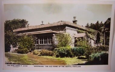
Postcard - Postcard - 'Burswood', The Old Home of the Hentys, Portland, Rose Stereograph Col Armadale, Victoria, 'Burswood', The Old Home of the Hentys, Portland, n.d
Displayed at History House.Coloured postcard of Burswood Homestead showing front and one side.Front: The Rose Series P10799 Copyright. 'Burswood', The Old Home of the Hentys, Portland. Back: The 'Rose' Series Deluxe. A real photograph. Produced in Australia. Published by the Rose Stereograph Col Armadale, Victoria. -
Glenelg Shire Council Cultural Collection
Flyer - DL Flyer - Warrock Homestead Casterton, n.d
DL flyer, black and white, single fold, advertising 'Warrock' homestead at CastertonFront: 'B. VIVIAN', handwritten blue biro. Red stamp 'RACV ACCOMMODATION BOOKING 123 Queen St MELBOURNE PHONE 600251' -
Glenelg Shire Council Cultural Collection
Photograph - Photograph - 'Netherby', Portland, n.d
Black and white photo of 'Netherby', North Portland. Bluestone house, full length verandah, metal verandah posts with wrought iron decoration. Several people on verandah, partly obscured by garden, two in garden; bird in cage on verandahBack: 'Netherby' North Portland Phyl Storer (Kerr)' - handwritten, red biro, top right cornernetherby, bluestone building, historic homestead -
Glenelg Shire Council Cultural Collection
Booklet - Catalogue - G. W. & M. R. Kittelty Auctioneers, Feb-80
Fifteen page catalogue, prepared by G.W. & M.R. Kittelty, auctioneers, for the auction of antiques, at 'Maretimo', Portland, 10th Feb. 1980. Heavy matte card cover, dull red and white, photo of 'Maretimo' across both covers. Pages white, red printauction, maretimo, historic house, historic homestead -
Glenelg Shire Council Cultural Collection
Flyer - Flier - 'Warrock' Homestead, Casterton, n.d
DL flyer, glossy paper, black and white, 'Warrock' Homestead, Casterton -
 Glenelg Shire Council Cultural Collection
Photograph - Photograph - Maretimo - Overlooking Dutton Way, n.d
On display at History House.Black and white photo showing view from Maretimo towards Dutton Way. Conifers in let foreground, with picket fence. Two Adults and a child behind fence looking towards Dutton Way.historic homestead, historic building, maretimo -
 Glenelg Shire Council Cultural Collection
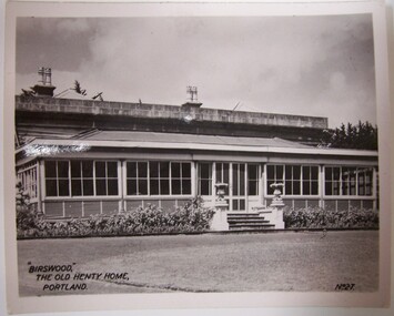
Photograph - Photograph - 'Burswood', The Old Henty Home, Portland, n.d
Displayed at History HouseBlack and white photograph of Burswood Homestead - front view.Front: 'Burswood', The Old Henty Home, Portland. No. 27 Back: Donated to History House by Mrs. B. Mackie, 1984.henty, historic homestead, burswood, portland home -
Glenelg Shire Council Cultural Collection
Slide - Slide - Glass Plate Negative, 1890-1910
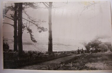
Glass plate negative. View from Caledonian Hill, looking east over Dutton Way. Homestead middle view. -
Glenelg Shire Council Cultural Collection
Photograph - Contact Print - Portland, Victoria, 1970s
Set of 3 pairs of stereoscopic contact prints from glass plate negatives. Top: View from hill overlooking homestead and outbuildings. Middle: paddocks, fence, sheep run. Bottom: View from south side Cliff Street - looking north along Bentinck Street railway cutting to station.portland scene, bentinck street, street scene, photography -
Glenelg Shire Council Cultural Collection
Photograph - Packet of 11 photographs (originally 12, 1 missing) of Portland and surrounds - 'Beauty Spots in Australia' - Portland Vic, c. 1930
... Cliff Street Portland great-ocean-road Front: 5838; 'Henty ...Packet of 11 photographs (originally 12, 1 missing) of Portland and surrounds. Identification numbers 5838 a-k a. Panorama of harbour b. Whalers Point c. Portland from Battery Point d. Piers and Battery Point e. The Harbour f. Looking to Whalers Point g. Blowholes, Cape Bridgewater h. Henty Beach j. 'Burswood' k. Bentinck StreetFront: 5838; 'Henty Homestead' - black biro -
Glenelg Shire Council Cultural Collection
Photograph - Photograph - Maretimo, Portland, n.d
Maretimo was built for John McLeod in 1854.Black and white photo of 'Maretimo'.Back: 'x -89' - pencilportland historic homes, historic homestead -
 Greensborough Historical Society
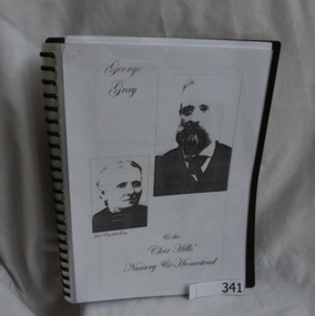
Folder, George Gray and the 'Cleir Hills' nursery and homestead, 1813o
Family history by Kay Walker, great grand-daughter of George and Jane Gray. The Gray family were the owners of the 'Cleir Hills' nursery in Cottlesbridge.George Gray's parents lived in Greensborough in the 1850s. His father Owen was a local storekeeper.Spiral bound folder with clear cover. Approx 40 photocopied pages of Gray family history.gray family, george gray, cleir hills, cottlesbridge -
 Greensborough Historical Society
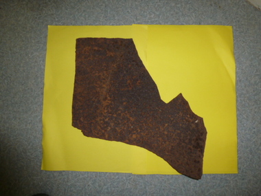
Bath and bed head (remnants), Partington family, remnants of bath and bed head, 1900c
This piece of an old bath dates back to the late 1800s to early 1900s. The bath would have been used by the Partington or Bosch families at the property at Point Lookout. This piece is from a bath that was used by our grandfather (born in 1872) when the family lived at Point Lookout before the Partington family bought Willis Vale in 1878. The bath remnant was retrieved after fire destroyed the house. Bed head (remnant): From the Willis Vale homestead. The Partingtons purchased Willis Vale in 1878. William James Partington (1872-1941) and his wife Annie May (1874-1965). They were the parents of Eva, Grace, Alan, Jess and Jack. All except Eva were born at Willis Vale. 9from Faye Fort)Remnants of two of the Partington family homes, both destroyed by fire.Cast-iron, rusted. Section of base of bath and one upright post from bed head.partington, bosch, willis vale, lookout point, baths, bed heads, furniture, greensborough -
 Halls Gap & Grampians Historical Society
Map - Coloured
Background on Bridle Path up Stony Creek Gorge Pre 1840 C. B. Hall, squatter on Mokepilly Run 1841-1842, first European to discover the Fyans Creek valley, the entrance of which became known as Hall's Gap. He later recorded that he followed a number of tracks which he assumed had been made by the Aboriginies and described one as "leading up a wild romantic glen and over on to the source of the Glenelg River". This could well have been the route taken up Stony Creek gorge by the first timber-cutters in this part of the Grampians to the saddle between the Wonderland and Mt. Difficult ranges known as Valley Gap 1850s/60s Timber cutters and shingle splitters were reported to be moving into the eastern side of the Grampians and by the mid 1860s there were a number of families connected to the supplying of timber to Pleasant Creek living in the "Hall's Gap ranges". John Wakeham, the first store owner in Pleasant Creek in 1854, established a timer-mill in upper Stony Creek Gorge in the late 1850s. Wakeham is credited for the clearing and levelling of the first bridle-path up the gorge. 1870s By the mid 1870s the track had been extended over Valley Gap to the Victoria Forest (the upper region of the Victoria Valley). McKeon's bullock team was known to have hauled red gum from the Valley to Stawell in the late 1870s and the 1880s. 1880s In 1887 an article in the Pleasant Creek news describes the Stony Creek Gorge track as "being a ledge alongside the mountain range, formed in the early days with the aid of earth and timber, along which the bullock teams used to travel to Horsham and plains of the Wimmera beyond." 1890s Gold was discovered in the catchment area of Stony Creek and by the end of the 1890s a new track was built from "near the junction of Fyan's and Stony Creeks, up the gorge to the diggings settlement. The mining Department had paid L300 for its construction and, when completed, the track was "three miles and 30 chains in length, the side cuttings at the narrowest part being 10 feet between" and "the watercourses which cross the track at various points" having been "filled up with rocks rolled down the sides of the hills, and consequently there can be no damage caused by bushfires which destroyed the former wooden bridges erected on the old track to Wakeham's saw-mill, the remains of which are still to be seen at the side of the diggings" The article goes on to further describe the track as one which "can with ease travel with a two horse conveyance either up or down" and that the workmen engaged in the construction of the track would be attending "a ball that night at McKeon's farm near the mouth of the gap to celebrate the successful completion of the undertaking". 1900s At what time the bridle path was extended beyond Valley Gap to the Wartook basin on the Mt. Difficult Range has not yet been determined. However, it is known that, by the turn of the century, people were travelling between Halls Gap and the caretakers' residence at Wartook Reservoir along what was now known as the "Bluff Road. Wartook's embankment had been constructed in 1887 and at that time there was already a track from Rosebrook Station homestead (near the present day Wartook Pottery) to the reservoir. Philip Rose owned both Rosebrook and Wartook Stations from the mid 1840s to the late 1850s and had regularly leased the Wartook basin to Cobb & Co. to rest horses there. 1920s Following the war of 1914-1918, tourism really took off in the Grampians, and Halls Gap rapidly grew. People would travel as far as they could on the many tracks then hike to the many lookouts being discovered by local tour guides. This led to the need for access across the range so that horse riders and the increasing number of vehicles could travel between Horsham and Halls Gap. To this end, the Bluff Road was improved and extended on 1929 and at its opening in March, 1930, by Lady Somers it was renamed the Mt. Victory Road.Map of Mt Victory Road and othersaccess routes, mt victory rd, bridle path, roads